By Mika Rantanen
Published August 10, 2026
As the month of August reaches its second week, a distinct pattern has emerged across the Finnish landscape: a summer that feels markedly restrained compared to the recent, blistering years of the past decade. For many Finns, this season has been characterized by a lingering, moderate coolness—a welcome reprieve for some, and a point of curiosity for climate observers.
New data from the latest meteorological reports confirms that the number of "hot days" (where temperatures exceed 25.1°C) across the country is currently at its lowest level in nine years. As we look toward the remainder of the summer, long-range forecasts suggest that the window for any significant heatwaves is closing rapidly. This cooling trend provides a critical opportunity to examine the variables—from regional atmospheric pressure to global oceanic phenomena—that define the Finnish summer.
The Anatomy of a "Normal" Summer
To the average observer, the perception of a "cool" summer is often relative. After several years of record-breaking heat and extended dry spells, the return to more temperate conditions can feel jarring. However, the data paints a more nuanced picture.
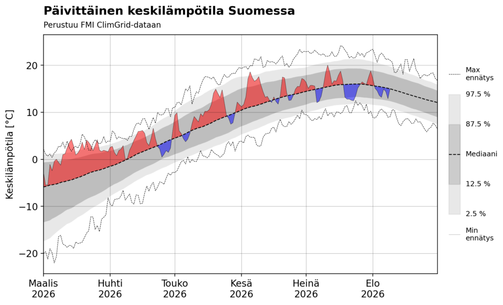
While the spring of 2026 was characterized by a persistent, unseasonable warmth, the transition into June marked a turning point. Since then, the weather has been defined by high volatility rather than sustained extremes. We have seen a lack of the long-duration, high-pressure systems that lock in either cold or warm air masses for weeks on end.
Because of this constant atmospheric churn, the average temperature for the summer of 2026 is, remarkably, very close to the long-term climatological average. The perception of "coolness" is largely a psychological contrast to the hyper-warm summers of the recent past, rather than a departure from historical norms.
However, there have been notable deviations. Mid-July saw a period of biting cold that felt distinctly autumnal. On July 23, the national average temperature plummeted to a mere 12.5°C, hovering near record-breaking lows for that specific date. Despite these dips, it is worth noting that no major national heat records have been shattered since March, suggesting a summer that, while erratic, has stayed within the bounds of historical standard deviations.
Counting the Heat: A Data-Driven Perspective
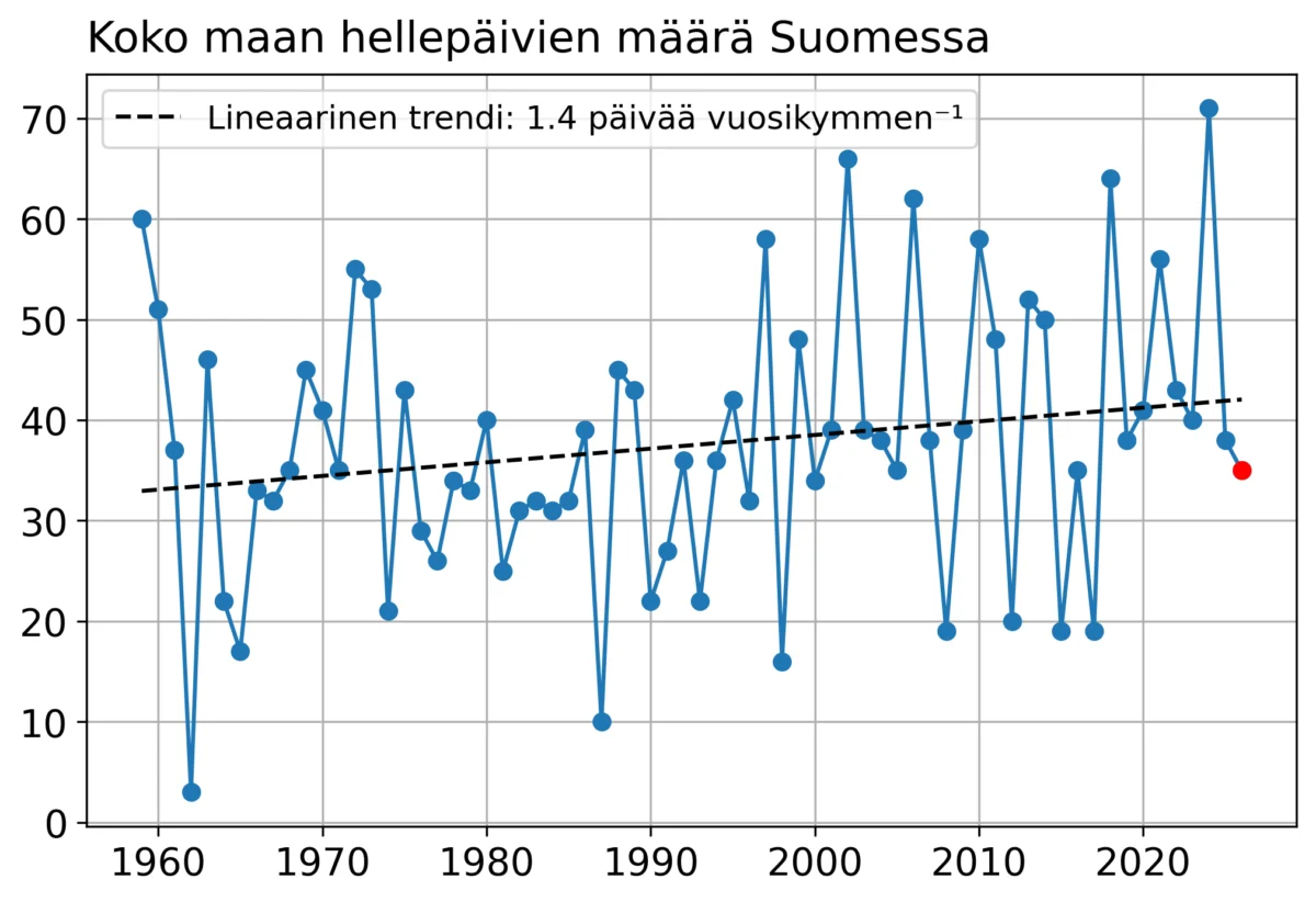
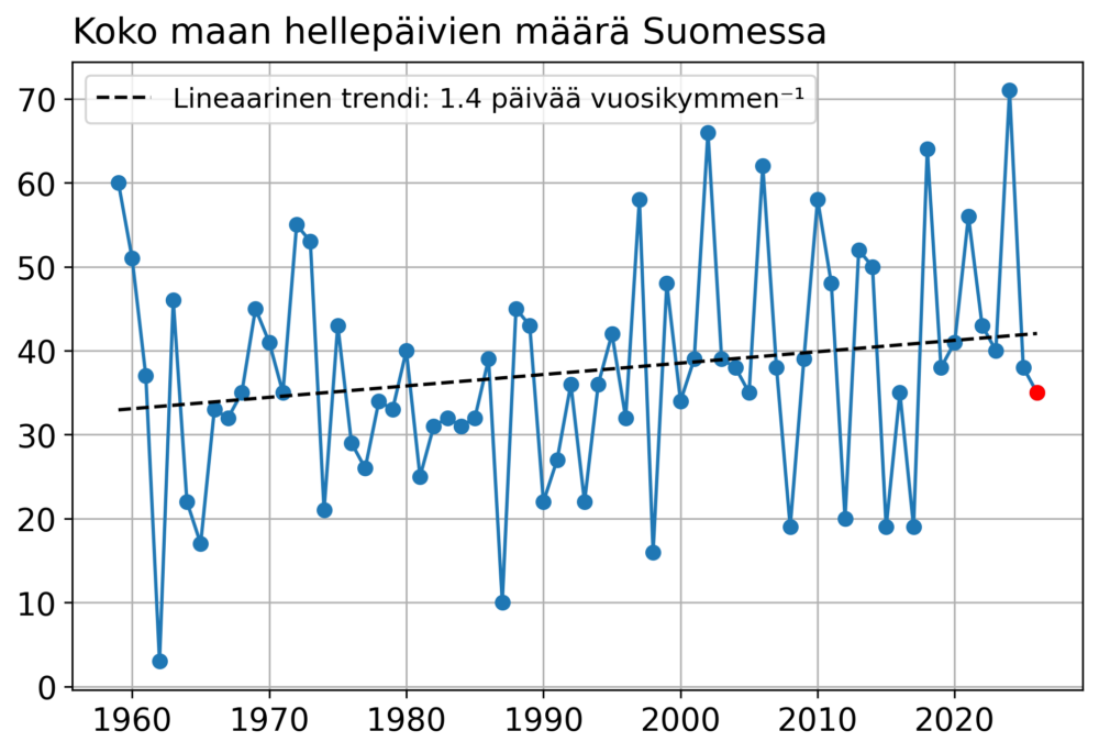
One of the most reliable indicators of a summer’s "intensity" is the tally of hot days. As of August 10, 2026, Finland has recorded 35 such days.
It is important to address a discrepancy in official reporting. While the Finnish Meteorological Institute (FMI) lists the count at 34, a deeper look at the raw data—specifically the measurement taken at Porvoo Harabacka on June 22—reveals a total of 35. The 25.1°C peak recorded in Porvoo occurred immediately after the 18:00 UTC cutoff time used for official reporting, causing it to be logged in the subsequent day’s records.
Meteorological reporting is governed by strict protocols. The FMI calculates daily maximums within the 18:00–18:00 UTC window, while heatwave statistics rely on the "daytime" maximum, measured between 06:00 and 18:00 UTC. This nuance in measurement protocol often creates a delta between raw observational data and official summarized reports.
Regardless of this minor statistical variance, the trajectory is clear: with 35 days, we are witnessing the lowest number of hot days since 2017. When compared against the 30-year median of 39 days, 2026 is slightly below the norm. However, climatologists caution against reading too much into a single year. When looking at the decadal trend, the frequency of hot days in Finland is clearly on the rise, and the relative absence of extreme heat this year is a statistical anomaly in a broader upward trajectory.
Global Drivers: Is El Niño the Architect of Our Weather?
Perhaps the most compelling question for meteorologists this year is why Finland and Fennoscandia have remained largely insulated from the intense heatwaves that have plagued Western and Central Europe. Throughout the summer, Western Europe and the British Isles have been gripped by a persistent "heat dome"—a high-pressure system in the upper atmosphere that traps hot air and repeats its cycle with monotonous frequency.
When a weather pattern remains this "locked," researchers look for macro-scale drivers. The primary candidate for 2026 is the exceptionally strong El Niño event that has been intensifying throughout the summer.
El Niño is a complex oceanic and atmospheric phenomenon that reshapes global weather patterns for months at a time. Historical data suggests a strong correlation between El Niño years and a specific temperature gradient in Europe: while Western and Central Europe experience significant, prolonged warming, the Nordic regions, including Finland, frequently find themselves on the periphery, subjected to cooler, more unstable air masses.
The current meteorological setup fits this classic El Niño profile. While no single summer can be reduced to one factor, the influence of the current oceanic event is significant. It acts as a primary atmospheric "governor," dictating where high-pressure ridges form and how they interact with the jet stream. We are currently seeing a clear divergence in the European climate experience, with the Mediterranean and Atlantic coasts paying the price for the stability of our own, more temperate northern summer. Future studies will undoubtedly focus on the link between the 2026 El Niño and the specific, localized heat-blocking patterns that spared Finland this year.
Implications for the Future
What does this mean for the future of the Finnish climate? While the summer of 2026 provides a reprieve, it is essential to view it through the lens of long-term climate modeling.
- The Normalization of Change: The fact that a "normal" summer now feels like an "exception" highlights how rapidly public perception of climate has shifted. We have become accustomed to the "new normal" of heat-stressed summers, making a standard year feel like a cold one.
- Predictability and Volatility: The high variability observed this year—rapid shifts between warm and cold pulses—is a hallmark of a changing climate. As the atmosphere warms, the stability of traditional weather systems becomes increasingly compromised.
- The Role of Global Connectivity: The 2026 season underscores how deeply connected the Finnish climate is to distant events. The temperature in our forests and cities is not just a local phenomenon but is inextricably linked to the heat content of the tropical Pacific and the pressure systems over the Atlantic.
As we move toward the end of August, the forecast remains consistent. There are no clear, sustained heatwaves on the horizon. We can expect sporadic pulses of warm air, but it is highly probable that the final count of hot days for the year will settle in the 35–40 range, firmly within the historical average.
For now, the Finnish landscape remains a testament to the complex, often unpredictable interplay of global and regional forces. While this summer may have lacked the intensity of its predecessors, it has offered a vital data point in the ongoing study of how our planet’s climate is shifting, reacting, and—in some regions—momentarily finding a balance.
As meteorologists continue to analyze the data from this summer, the primary takeaway remains clear: the climate is not a static background, but a dynamic, ever-changing system. And while we may enjoy the relief of a cooler, more temperate season, the underlying trends toward warming remain as relevant as ever.
Key Data Summary (As of August 10, 2026)
- Total Hot Days (25.1°C+): 35 (unofficial count including corrected data).
- 30-Year Median: 39 days.
- Lowest Temperature Event: July 23, national average 12.5°C.
- Primary Climate Driver: Significant El Niño influence, contributing to the "Heat Dome" in Western Europe and cooler, unstable air in Fennoscandia.
- Outlook: No significant heatwaves forecasted for the remainder of August.
Mika Rantanen is a research meteorologist tracking the evolving patterns of the Northern climate. This analysis is part of a broader study into the long-term impacts of global ocean temperatures on regional Nordic weather systems.