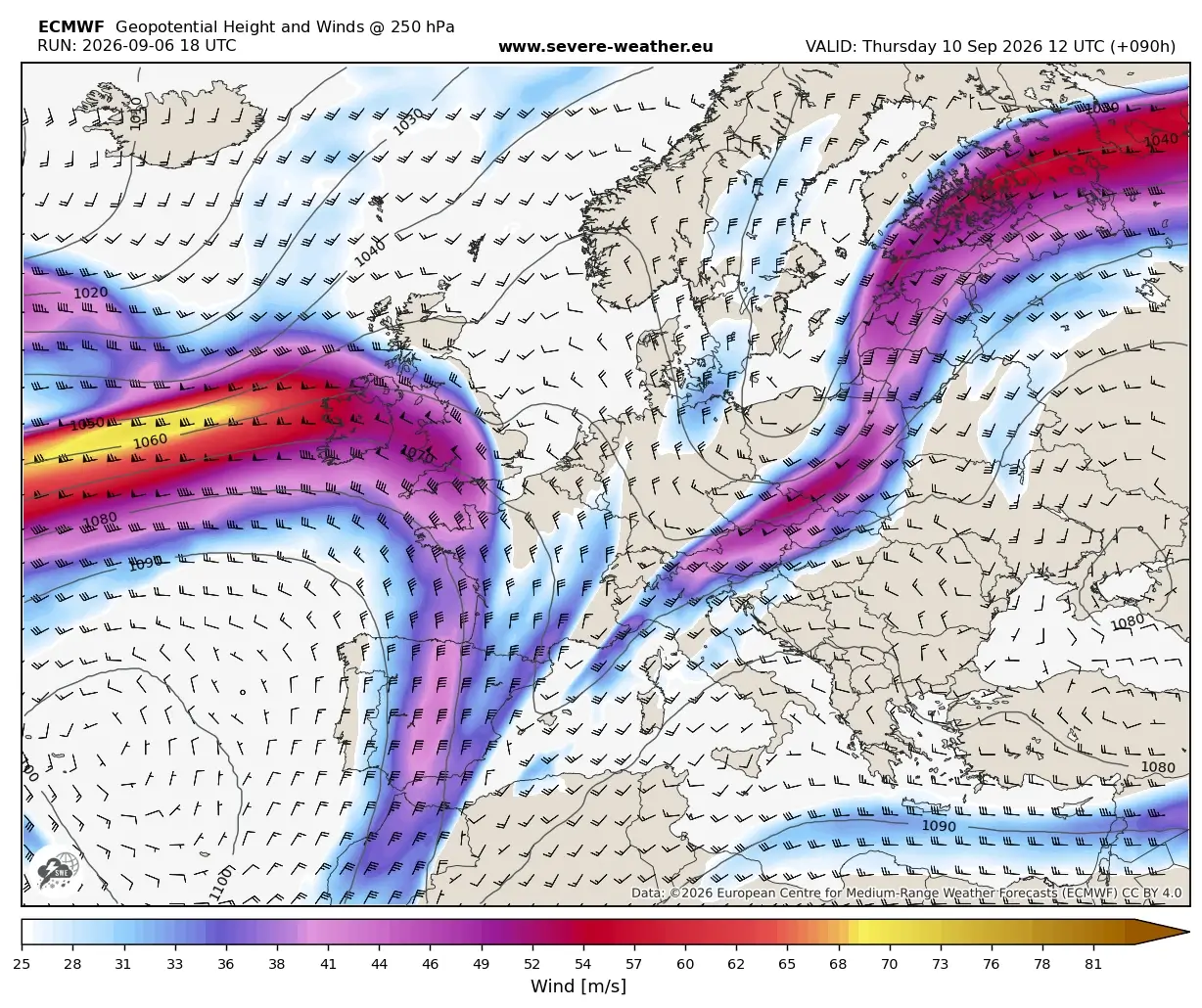
A dramatic atmospheric "summer-killer" pattern is currently unfolding across the European continent, marking a sudden and violent conclusion to the prolonged, record-breaking Heat Dome that has gripped the region throughout early September. A high-amplitude upper-level trough, surging from the North Atlantic, is currently driving a potent surface cold front deep into Western and Central Europe. This collision between an entrenched, extreme warm air mass and an incoming, frigid polar surge is creating a volatile meteorological environment, setting the stage for a widespread, multi-day severe weather outbreak stretching from the crags of the Alps to the Western Balkans.
The Synoptic Setup: Collapse of the Heat Dome
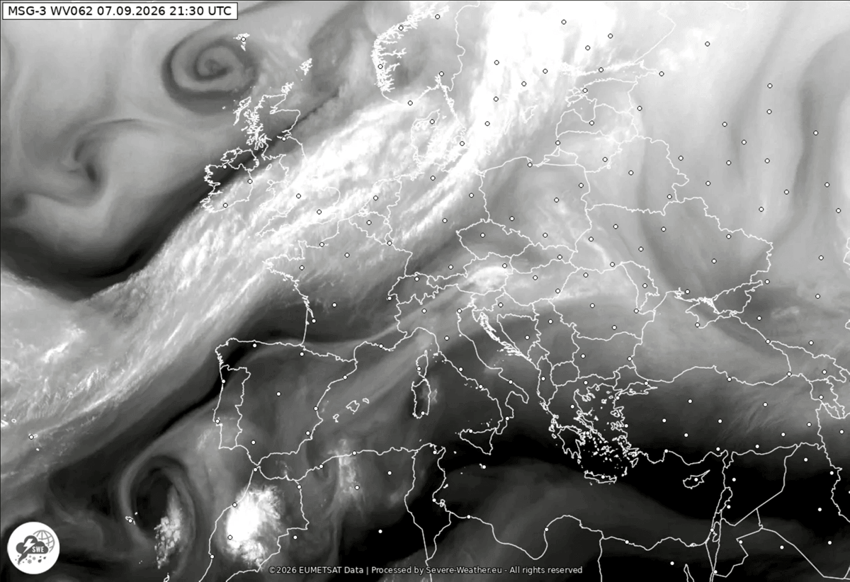
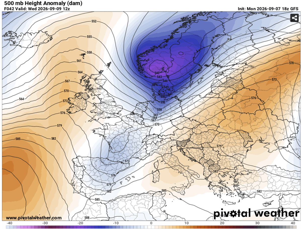
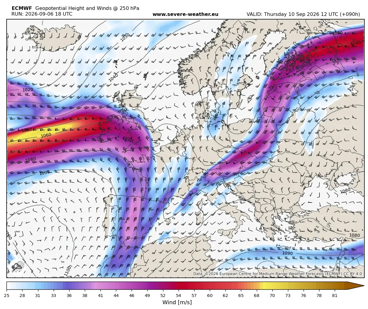
For weeks, a persistent upper-level ridge has trapped stagnant, record-warm air over Europe, creating a Heat Dome that shattered temperature records across multiple nations. However, the synoptic landscape is undergoing a rapid, high-magnitude shift. Meteorologists are observing the breakdown of this ridge as a powerful upper-level wave pushes eastward from the North Atlantic.

By Tuesday, this trough began infiltrating Western Europe, signaling a structural collapse of the blocking high that sustained the heatwave. As the trough advances, it is essentially "flushing" the heat out of the continent. While this transition promises relief from the oppressive temperatures, the mechanism of this shift is inherently dangerous. A secondary wave is expected to cut off into the Northern Mediterranean, spawning a surface low that will track across Italy and into the Western Balkans. This system acts as a conduit for severe weather, drawing in moisture-laden, unstable air from the Mediterranean—currently experiencing its own historic marine heatwave—and forcing it upward against the advancing cold front.
Chronology: A Two-Day Window of Instability
The transition is not a gradual cooling; it is a thermal shock. The meteorological events are unfolding in a distinct, high-stakes timeline:
Wednesday: The Frontal Assault
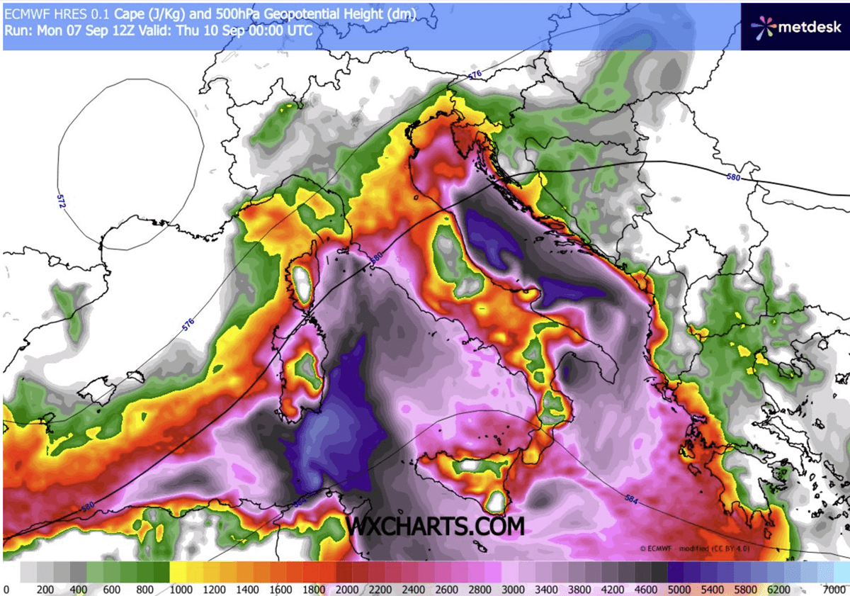
By Wednesday, the high-amplitude ridge will have fully disintegrated under intense upper-level forcing. As the front pushes east, it will encounter an atmosphere characterized by extreme instability, with CAPE (Convective Available Potential Energy) values forecasted to reach between 3,000 and 4,000 J/kg in certain corridors.
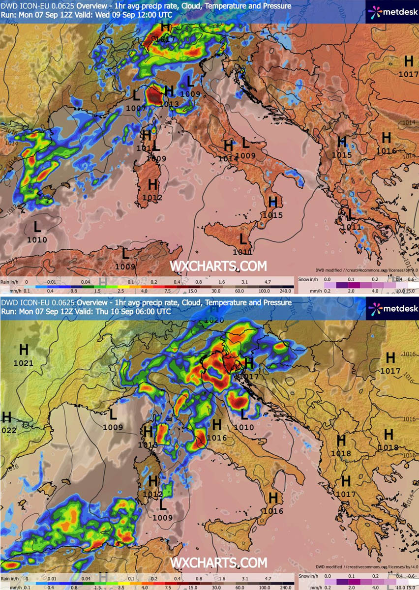
During the midday hours, the Balearic Islands will be the first to experience the brunt of the instability. As the day progresses into the evening, the focus of the severe weather will shift toward Northern Italy and the North Adriatic. Residents in these regions should prepare for multicell and supercell storm systems capable of producing large-to-giant hail, destructive wind gusts, and intense, localized tornadic activity.
Thursday: The Balkan Transition
As the surface low drifts toward the Western Balkans, the frontal system will slow down, further intensifying the rainfall potential. Thursday will see the atmospheric energy concentrated over Slovenia, Croatia, and the surrounding regions. The "training" of storm cells—where multiple intense storms pass over the same location in quick succession—will create a significant flash flood risk. By late Thursday, the polar-origin air mass will have fully overspread Central Europe, resulting in a dramatic, 24-hour thermal collapse.
Supporting Meteorological Data and Thermal Analysis
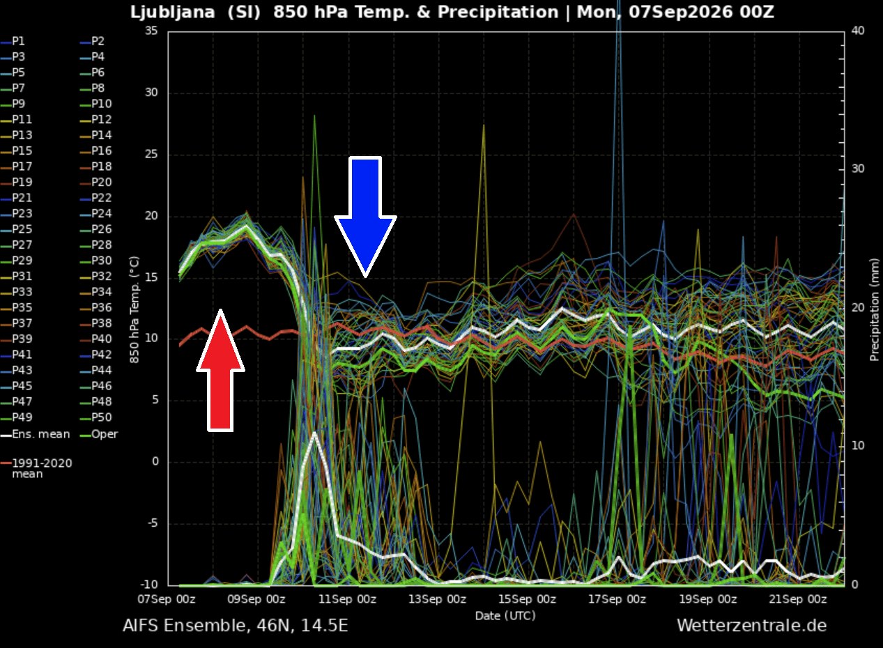
The sheer scale of this transition is captured in high-resolution meteogram data. In regions like Ljubljana, Slovenia, temperatures at the 850 mbar level are expected to drop by approximately 15°C in less than 24 hours.
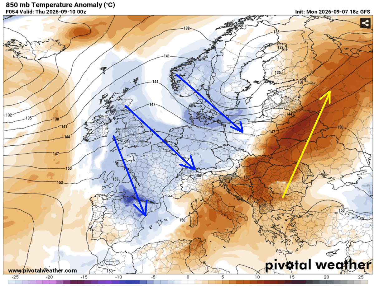
To put this in perspective, daytime highs that hovered between 35°C and 40°C early in the week will plummet to levels more characteristic of late autumn. This "summer-killer" pattern is defined by the rapid replacement of warm-sector air with a cold, polar-origin air mass. The thermal gradient along the frontal boundary is exceptionally tight, which is the primary driver for the severe convective activity.
Furthermore, the record-breaking marine heatwave in the Mediterranean has elevated sea surface temperatures to levels that provide an immense reservoir of moisture. This moisture, when intercepted by the cold front, acts as high-octane fuel for the developing storms, ensuring that the rainfall is not only widespread but potentially torrential. Hydrological models suggest that rainfall totals could reach 150–200 mm in select areas over a 48-hour period, posing a critical threat to infrastructure in the Liguria Bay and North Adriatic coastal zones.
Implications for the Region
The consequences of this transition extend far beyond the immediate threat of severe storms and flash flooding.
Infrastructure and Urban Vulnerability
The rapid transition from prolonged heat to torrential rain creates specific vulnerabilities for urban environments. Dry, baked soil often lacks the permeability to absorb sudden, high-intensity rainfall, drastically increasing the risk of urban flash flooding. Municipalities along the Adriatic coast are on high alert for the potential of blocked drainage systems and overwhelmed water management infrastructure.
Alpine Transformation
For the higher elevations of the Alps, this event represents a sudden transition into winter-like conditions. Meteorologists predict that the plummeting temperatures will bring the first significant snowfall of the season to high-mountain passes. This rapid cooling, coupled with the potential for heavy, wet snow, may lead to hazardous driving conditions on high-altitude transit routes and could impact late-season mountaineering activities.
Agricultural and Economic Impacts
The agricultural sector, already strained by the prolonged heatwave, faces further disruption. While the rain is objectively "much-needed" to alleviate the drought conditions caused by the Heat Dome, the intensity of the precipitation and the risk of giant hail threaten to damage crops that have survived the summer heat. The economic implications of this transition will be felt across the supply chain, particularly regarding transport delays caused by the severe weather.
Official Guidance and Public Safety
National weather services across Central Europe and the Balkans have begun issuing warnings, advising citizens to monitor local forecasts closely. The consensus among meteorologists is that this is not a typical late-summer cold front; the high CAPE values and the specific synoptic structure necessitate extreme caution.
- Avoid Flood Zones: Authorities are urging the public to avoid low-lying areas, riverbanks, and coastal zones prone to flash flooding during the passage of the front.
- Secure Property: Given the potential for giant hail and severe wind gusts, citizens are advised to secure outdoor furniture, vehicles, and temporary structures.
- Monitor Updates: Due to the volatile nature of the supercell storms, official forecasts may be updated with short-notice warnings. Residents are encouraged to rely on official meteorological channels rather than anecdotal social media reports.
A New Meteorological Reality
As Europe moves into the latter half of September, this event serves as a stark reminder of the increasing volatility of the continental climate. The shift from a historic Heat Dome to a major, multi-country severe weather outbreak highlights the complex, interconnected nature of Mediterranean moisture, North Atlantic wave patterns, and shifting Arctic air.
While the "summer-killer" pattern will successfully flush out the heat, it leaves in its wake a landscape redefined by sudden, high-impact weather. The coming weekend will bring a crisp, autumn-like atmosphere to Western and Central Europe, providing a period of stability, yet the memory of this rapid, violent transition will likely linger as a case study in extreme seasonal shifts. Meteorologists will continue to monitor the evolution of the deep upper trough as it moves east, with further updates expected as the frontal system completes its transit across the continent.