By Mika Rantanen
Published: August 20, 2026
While much of the public discourse regarding climate change focuses on heatwaves, the summer of 2026 in Finland has been defined by a different, more destructive force: extreme, localized precipitation. From flooded basements to the structural failure of bridges, the meteorological narrative of this year has been dominated by rainfall events that test the limits of our infrastructure and our understanding of "normal" weather.
As we analyze the data from this summer, a clear pattern emerges. While a 100-millimeter daily rainfall remains a once-in-a-century statistical rarity for any single specific location, the occurrence of such events somewhere within Finland’s borders is becoming increasingly common—bordering on annual.
The Anatomy of an Extreme Event: The August Deluge
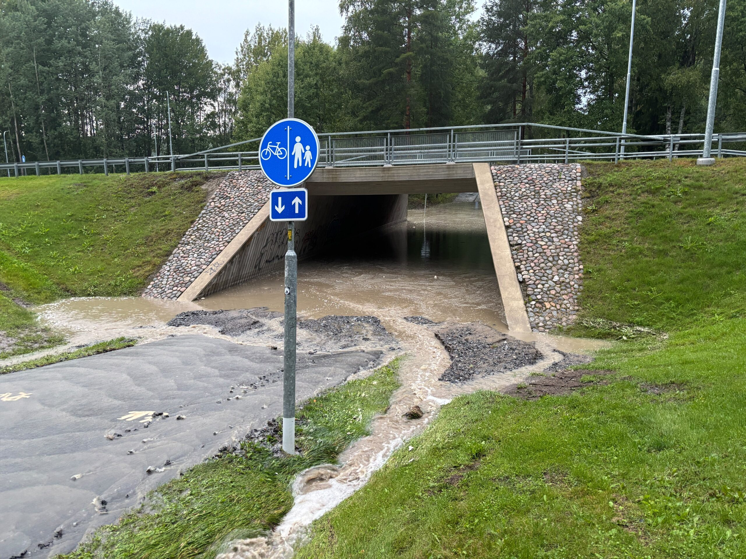
The summer of 2026 has been marked by a shift in meteorological volatility. Rather than persistent heat, the season has been punctuated by intense, high-impact downpours. One such event occurred last week in Seinäjoki, where the sheer volume of water overwhelmed drainage systems and led to significant urban flooding, a phenomenon also observed in Tampere.
To understand the scale of these events, one must look at the threshold set by the Finnish Meteorological Institute (FMI). The institute issues a yellow warning—the lowest tier—when hourly precipitation reaches 20 millimeters or daily totals hit 50 millimeters.
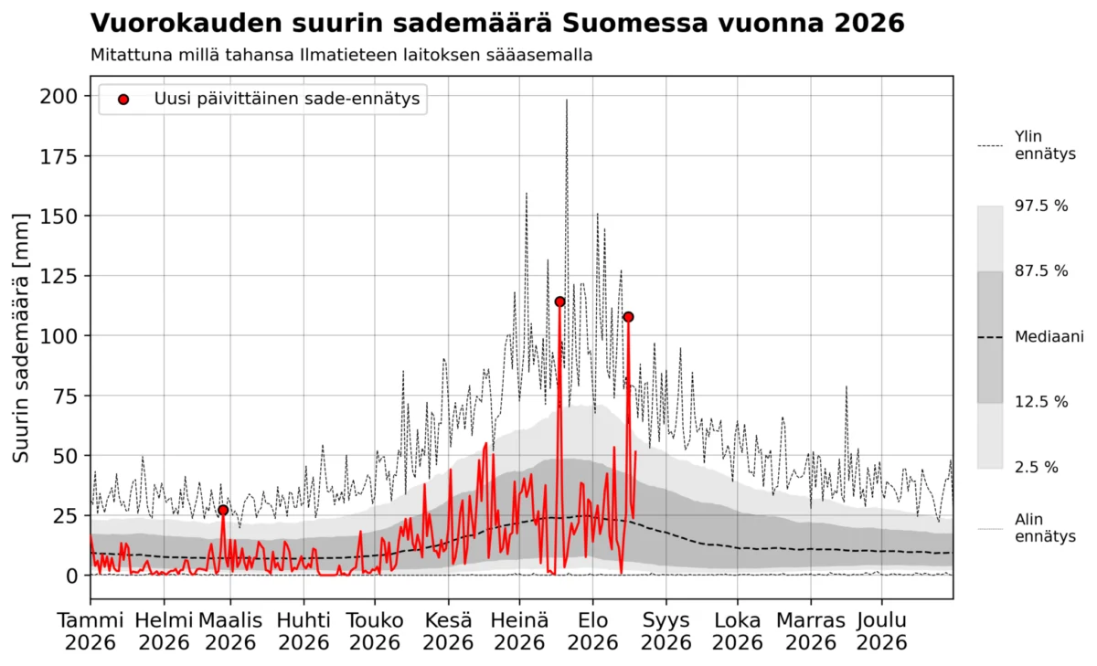
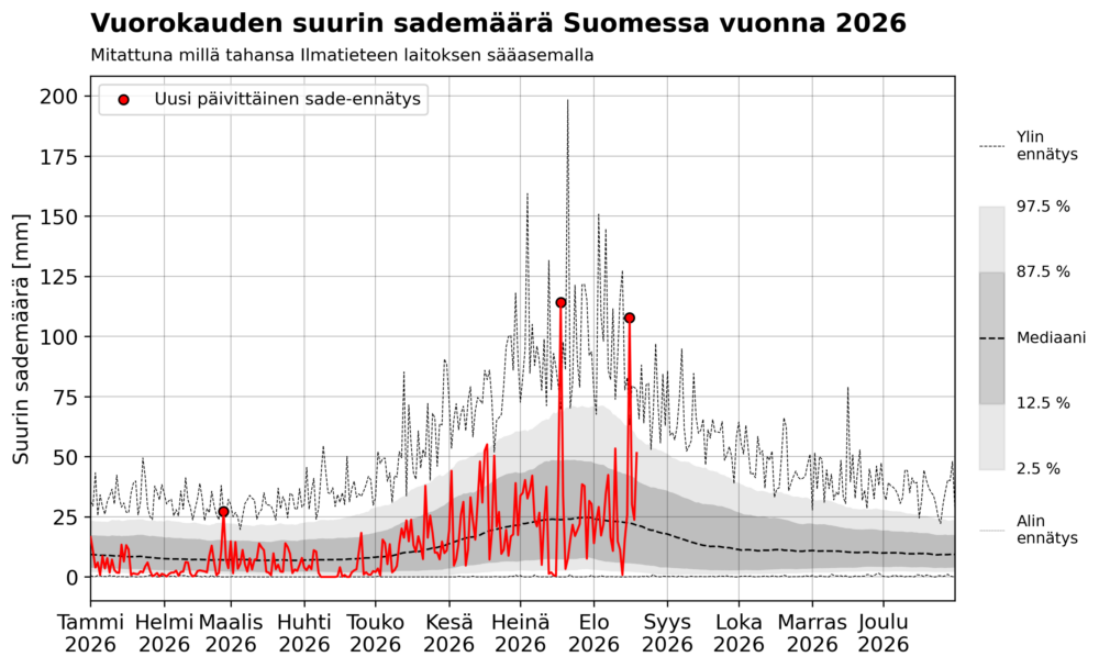
On Sunday, August 16, 2026, the Pelmaa station in Seinäjoki shattered these benchmarks. Within a single hour, the area recorded 68.6 millimeters of rain, with the 24-hour total reaching a staggering 107.7 millimeters. Had this occurred in a more densely populated area with less resilient infrastructure, the damage would have been catastrophic. By any standard, this event would have necessitated a "red" level warning—the highest severity. This was not an isolated incident; on July 18, 2026, the town of Multia also recorded a 24-hour total exceeding 100 millimeters.
Statistical Rarity vs. National Probability
The question arises: how truly exceptional are these 100-millimeter daily totals? To answer this, meteorologists look at the situation through two distinct lenses: the probability of a specific location experiencing such a deluge, and the probability of it occurring somewhere in Finland.
The Localized Perspective
According to the climate guides and frequency tables provided by the FMI, the return period for a 100-millimeter daily rain event is extremely long. When examining historical data, the average 100-year return level for most stations is well under 100 millimeters. For instance, at the Kauhava airport, the 100-year return level is 84 millimeters, while the 500-year level is 114 millimeters.
Because Seinäjoki shares a similar climatic profile to Kauhava, experts estimate that the mid-August downpour falls somewhere between a 100-year and a 500-year event. For the average person, witnessing such an event in their lifetime is statistically unlikely. However, it is vital to note that because these events are so rare, the precision of these return-period calculations is inherently uncertain.
The National Perspective
When we broaden the scope to include the entire country, the story changes. In recent years, the FMI has digitized a massive archive of weather observations, providing us with over a century of daily rainfall data. This data suggests that while a 100-millimeter event is a "once-in-a-century" event for a single point, it is far from rare when viewed across the entire Finnish landscape.
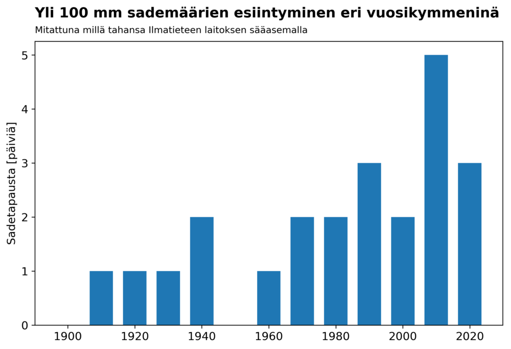
Historical records from 1910 to 2026 show 23 instances where at least 100 millimeters of rain fell in 24 hours at some location in Finland. Statistically, this suggests that such an event occurs somewhere in the country roughly every five years. Yet, the data from the last two decades suggests we are entering a new, more intense phase of meteorological history.
A Changing Climate, A Changing Trend
The summer of 2026 has been particularly notable because it produced two separate instances of 100-millimeter daily totals. Only four years in the recorded archive—2004, 2011, 2018, and 2026—have seen more than one such day in a single summer.
When we break down these 23 extreme events by decade, a concerning trend becomes visible. The current decade (2020–2026) has already seen three such cases. The previous decade (2010–2019) saw five. In just the last 17 years, there have been eight instances of 100-millimeter rainfall—nearly one every two years.
While researchers must be cautious—as the density of the FMI’s observation network has changed over time and historical digitization is an ongoing process—the upward trend is undeniable. These findings are in complete alignment with current climate change models, which predict a warmer atmosphere capable of holding more moisture, thus fueling more intense convective rainfall.
The Infrastructure Challenge: Preparing for the "New Normal"
The implications of these findings extend far beyond meteorology; they are a direct challenge to urban planning and civil engineering.
Current Warning Systems
The FMI’s current warning system is designed to provide alerts for the general public, but as the climate warms, the threshold for what constitutes a "damaging" event is shifting. A 20-millimeter-per-hour rain, while technically a "yellow" warning, can cause localized flooding in modern urban environments where impermeable surfaces (asphalt and concrete) prevent natural infiltration.
Engineering for Resilience
The research suggests that the frequency of the most intense precipitation events—those exceeding 20 millimeters per hour—is expected to roughly double by the end of the century under the RCP4.5 emission scenario. If global warming continues at a more aggressive pace, that multiplier could be significantly higher.
This creates an urgent need to rethink how we build. Infrastructure designed based on 20th-century statistics is increasingly failing under 21st-century conditions. Engineers must now account for a "fat-tailed" distribution of weather risks, where extreme events that were previously thought to be statistically impossible are now expected occurrences.
Historical Context and the Records of the Past
It is important to remember that extreme rainfall is not a new phenomenon in Finland. The all-time national record remains the 198.4 millimeters recorded in Lahnus, Espoo, on July 21, 1944. This event, occurring in the middle of a war-torn summer, serves as a reminder that nature has always been capable of extreme volatility.
However, the temporal distribution of these events is shifting. Historically, the vast majority of 100-millimeter events occurred between late June and mid-August. The fact that the 107.7-millimeter event in Seinäjoki took place on August 16, 2026, makes it the latest-occurring 100-millimeter daily rainfall in Finnish recorded history. This shift in seasonality suggests that the window of vulnerability is expanding, potentially extending into late summer and autumn months as the Baltic Sea stays warmer for longer, providing more energy and moisture to the atmosphere.
Conclusion: Adapting to a Wetter Future
The data provided by the FMI serves as both a scientific record and a societal warning. While we may not be able to predict exactly which town will be hit next, we can say with increasing confidence that the probability of extreme, damaging rainfall is rising.
The difference between a 100-year event at a local level and a "every other year" event at a national level is the crux of the adaptation challenge. For the citizen in a specific municipality, the risk remains low on an individual basis. But for the nation as a whole—for the state, insurance companies, and urban planners—the risk is constant and growing.
Moving forward, the focus must shift from merely tracking these records to building the resilience required to withstand them. As the atmosphere continues to warm, the "once-in-a-century" flood may soon become a biennial reality. We must update our flood defenses, improve urban drainage capacity, and integrate the latest climate research into the very foundation of our infrastructure. The rain is coming; the question is no longer if, but how well we will be prepared when it arrives.