By Mika Rantanen
The year 2026 has been marked by an anomaly that has caught the attention of meteorologists and casual weather observers alike: a striking lack of storm activity across Finland. As of the end of September, the country has recorded only five days of storm-force winds. In a landscape where the atmospheric temperament often dictates the rhythm of daily life, infrastructure, and maritime operations, this lull in activity serves as a compelling case study for both current climate variability and the complexities of long-term meteorological trends.
While the data suggests a remarkably calm start to the year, experts caution against viewing this as a sign of a permanent shift in climate behavior. Instead, it serves as a reminder of how large-scale atmospheric patterns—often referred to as "synoptic weather regimes"—can dictate the frequency of severe events in the short term, even when the broader long-term trajectory remains unchanged.
Main Facts: A Year of Atmospheric Stability
For the purposes of meteorological tracking, a "storm day" is defined by wind speeds reaching at least 21 meters per second (m/s) in Finnish marine areas. Between January and September 2026, these conditions were met on only five calendar days.
To contextualize this, one must look at the median frequency for the same nine-month period over the last two decades (2006–2025), which stands at 18 days. Since consistent data collection began in 2006, there has only been one instance where the first nine months of the year were quieter: 2006, which saw only four such days.
This dramatic deviation from the norm—a 72% decrease compared to the twenty-year median—is primarily attributed to an exceptionally persistent high-pressure system that dominated Northern Europe throughout the winter months. In meteorology, high pressure acts as a "blocking" mechanism, diverting the path of low-pressure systems (cyclones) that typically bring the winds and precipitation characteristic of the region’s autumn and winter seasons.
Chronology: The Winter of "Blocking" Highs
The scarcity of storms was most pronounced during the first two months of 2026. January and February were characterized by stagnant, cold, and exceptionally dry conditions. During this two-month window, which is historically a period of heightened activity, Finland’s marine areas experienced storm-force winds on only one single day. Statistically, the long-term average for January and February is eight storm days.
This "blocking" high-pressure regime acted as a barrier to the Atlantic storm tracks that usually feed into the Nordic region. By maintaining a high-pressure center over Northern Europe, the atmosphere prevented the development and encroachment of the intense, fast-moving cyclones that otherwise define the winter climate in Finland.
While the spring and summer months often exhibit lower storm frequency naturally, the absence of activity during the prime winter window set a low baseline that has persisted throughout the third quarter. However, the meteorological calendar is far from closed. The final quarter of the year, spanning October through December, is historically the most active period for Northern European storm development. Statistics indicate that approximately 50% of the year’s total storms occur within this final 25% of the calendar year.
Supporting Data: The Statistical Reality of Variability
A common misconception in public perception is that a quiet start to the year suggests a quiet end. Meteorological data, however, suggests the opposite: the correlation between the number of storm days in the first nine months of the year and the final three months is virtually non-existent.
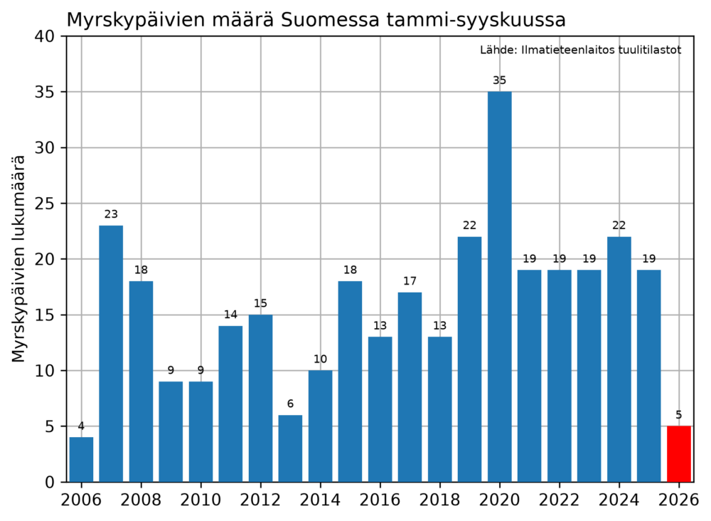
Analyzing the data from 2006 to 2026, the correlation coefficient (R) between the January–September and October–December periods is approximately -0.07. This negligible figure confirms that a "calm" year to date holds no predictive power for the intensity of the upcoming winter.
Historical precedents illustrate this volatility:
- The 2006/2013 Pattern: Both years began with minimal storm activity, yet both concluded with significantly higher-than-average storm counts in the final quarter (13 days and 18 days, respectively).
- The 2020 Contrast: In 2020, which remains the stormiest year in the current dataset with 35 recorded days, the trend was inverted. A highly active start was followed by a relatively tranquil end, with only nine storm days occurring in the final quarter.
The data underscores that the atmosphere is not a "budgeted" system; it does not "make up for" lost storms, nor does a quiet start guarantee a quiet finish. Each atmospheric configuration is a result of the specific, fluid dynamics of the current season.
Synoptic Analysis: Pressure Gradients and Atmospheric "Chicken and Egg"
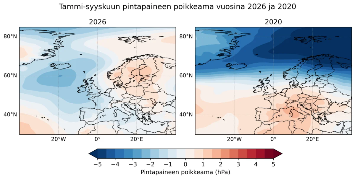
To understand why 2026 has been so quiet, we must compare it to a high-activity year, such as 2020. By utilizing the ERA5 reanalysis data—a comprehensive dataset providing a global climate and weather record—we can observe the pressure anomalies that drove these different outcomes.
In 2026, the atmospheric pressure over the Nordic countries was consistently higher than the historical average. This high-pressure environment effectively suppresses the vertical motion required for intense cyclones to deepen and intensify. Conversely, in 2020, the pressure was significantly lower than average over Finland and the areas to its north. This created a steep pressure gradient—a sharp change in air pressure over a given distance—which acts as a catalyst for high-velocity winds.
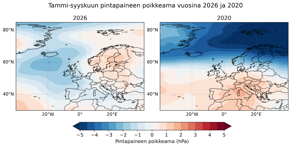
This gradient is the engine of the westerlies. When the pressure difference between the lower and higher latitudes is large, the jet stream accelerates, steering low-pressure systems directly into the Nordic region with increased energy.
However, scientists warn against a simplified "cause and effect" interpretation. While the large-scale pressure state influences the frequency of storms, the storms themselves possess the energy to modify the pressure field. This is the classic "chicken and egg" problem of atmospheric science: Does the pressure regime cause the storms, or do the storms, by transferring massive amounts of heat and momentum, force a change in the regional pressure field? Because of this feedback loop, researchers cannot definitively state that the lack of storms in 2026 was solely caused by the observed high-pressure anomalies; rather, they are parts of a single, complex, and interconnected system.
Long-term Trends: Is the Climate Changing?
When looking beyond the year-to-year fluctuations, a vital question emerges: Is the number of storms increasing due to climate change?
Using the ERA5 reanalysis data, which provides reliable satellite-era records dating back to 1979/1980, we can assess the long-term trend of Northern European storminess. By identifying low-pressure systems that produce gust speeds exceeding 25 m/s (which corresponds to approximately 21 m/s at the surface, taking into account the known minor negative bias in the model), we can create an objective historical map of activity.
The data reveals that there is no statistically significant upward or downward trend in the number of these storms over the last four decades. While the count fluctuates wildly from year to year—with the most active year in the dataset being 1983 and the least active being 2010—the long-term average remains remarkably stable.
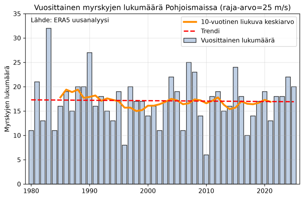
This finding is crucial for public policy and infrastructure planning. It suggests that while the nature of storms—such as their moisture content or the specific paths they take—may be influenced by a warming climate, the frequency of high-wind events in Northern Europe has not yet shown a clear, long-term shift.
Implications: Preparing for the Unknown
For the forestry, energy, and transport sectors, the quiet of 2026 provides a temporary reprieve from the economic costs associated with storm damage. However, it also serves as a reminder of the inherent unpredictability of the northern climate.
The lack of activity in the first three quarters of 2026 is an interesting footnote in the annals of meteorology, but it should not be mistaken for a permanent alteration of the environmental baseline. As researchers continue to refine their models and prepare more comprehensive studies on storm behavior in the changing Arctic and sub-Arctic climate, one fact remains clear: the atmosphere is a dynamic, chaotic system.
The current lack of storms is a consequence of a specific, transient configuration of high pressure. Whether the final months of 2026 will bring the standard autumnal fury or continue the current trend of anomalous quiet remains to be seen. In the meantime, the data serves as a compelling reminder that in the realm of weather, the only certainty is that the next pattern, however extreme or mild, is merely a cycle away.
As we look toward the future, more in-depth research is underway. The scientific community is currently finalizing broader analyses that will provide a more granular understanding of how regional atmospheric circulation is evolving. Until then, the records of 2026 stand as a testament to the fact that, even in a world of shifting climates, the variability of the weather remains our most constant companion.