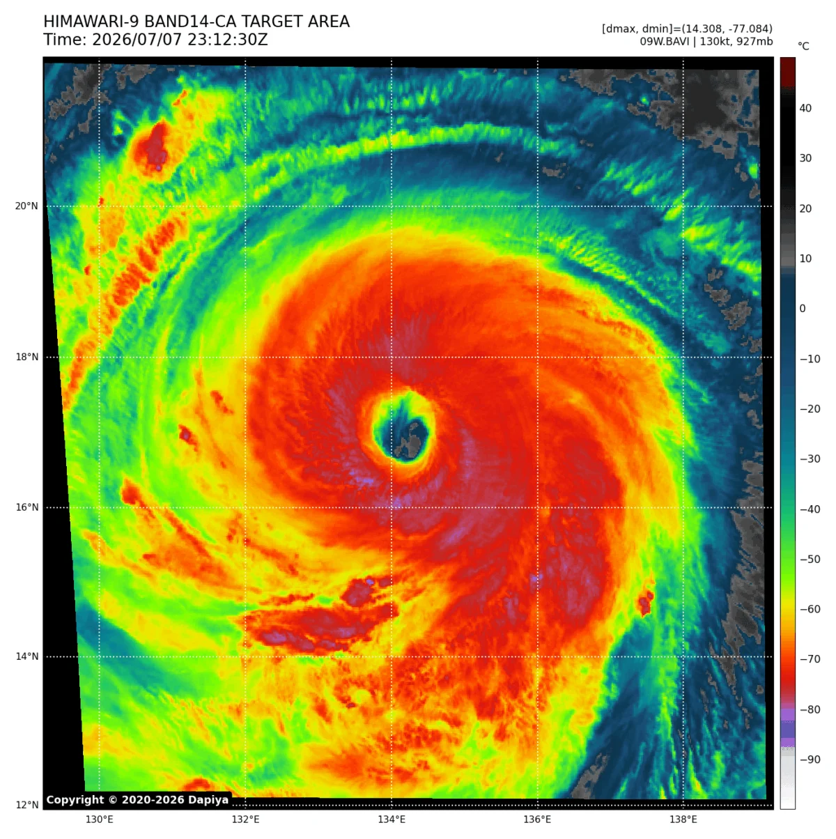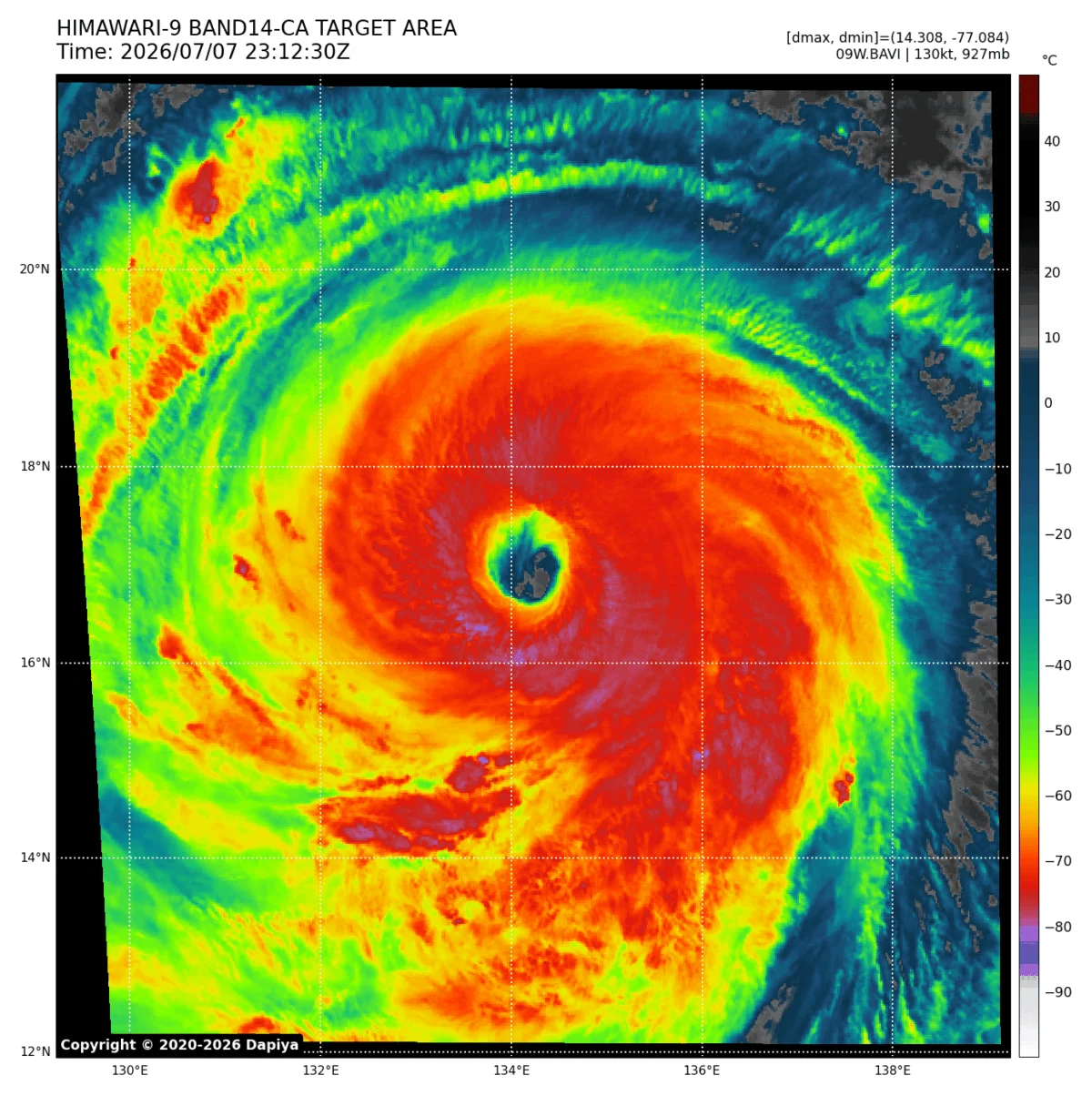
The Western Pacific has once again demonstrated the raw, unbridled power of nature as Super Typhoon Bavi transitions from a modest tropical disturbance into a colossal, Category 5-equivalent atmospheric monster. In an astonishing display of rapid intensification, the storm surged from 60-mph sustained winds to a violent 180-mph powerhouse in less than 48 hours. This meteorological phenomenon has placed the entire region on high alert, as Bavi solidifies its status as one of the most significant and destructive storms of the current season.
With a central pressure bottoming out at 901 mbar, the storm is not merely a threat due to its wind speed; its sheer size and expanding wind field present a multi-faceted danger to the Northern Mariana Islands, southern Japan, Taiwan, and the eastern coast of China.

The Anatomy of an Atmospheric Monster
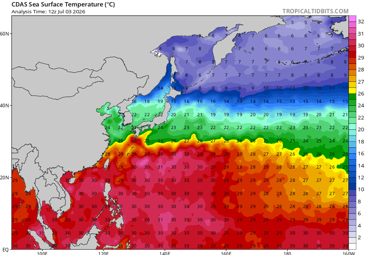
The rapid intensification of Super Typhoon Bavi is a textbook case of a tropical system capitalising on near-perfect atmospheric and oceanic conditions. Experts point to the exceptionally warm, deep oceanic waters—ranging from 29°C to 32°C—as the primary fuel source for the storm’s explosive growth.
When coupled with near-zero vertical wind shear, these high sea-surface temperatures (SSTs) created a "perfect storm" environment. This environment allowed for superior atmospheric outflow and upper-level ventilation, essentially acting as an exhaust system that permitted the storm to deepen and expand its circulation. After completing a classic eyewall replacement cycle—a process where a new, larger eye forms around the original, temporarily weakening the storm before it re-emerges with greater structural integrity—Bavi has returned as a significantly more dangerous, broader entity.
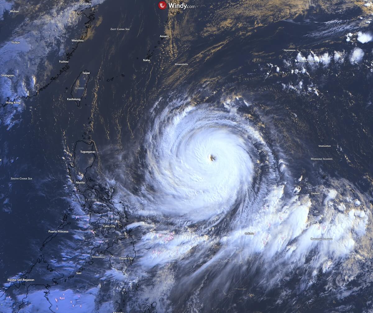
Chronology: A Path of Destruction
The destructive capabilities of Bavi were first witnessed by the Northern Mariana Islands. The storm’s northern eyewall made a direct, punishing pass over the island of Rota. Residents endured hours of catastrophic, hurricane-force winds and torrential rainfall, resulting in significant structural damage and widespread power outages.
Guam, a frequent target in the region known as "Typhoon Alley," also felt the sting of the storm. Weather stations on the island recorded wind gusts peaking at 85 mph, accompanied by staggering rainfall totals exceeding 20 inches. This influx of water has raised immediate concerns regarding landslides and flash flooding across the region’s rugged terrain.
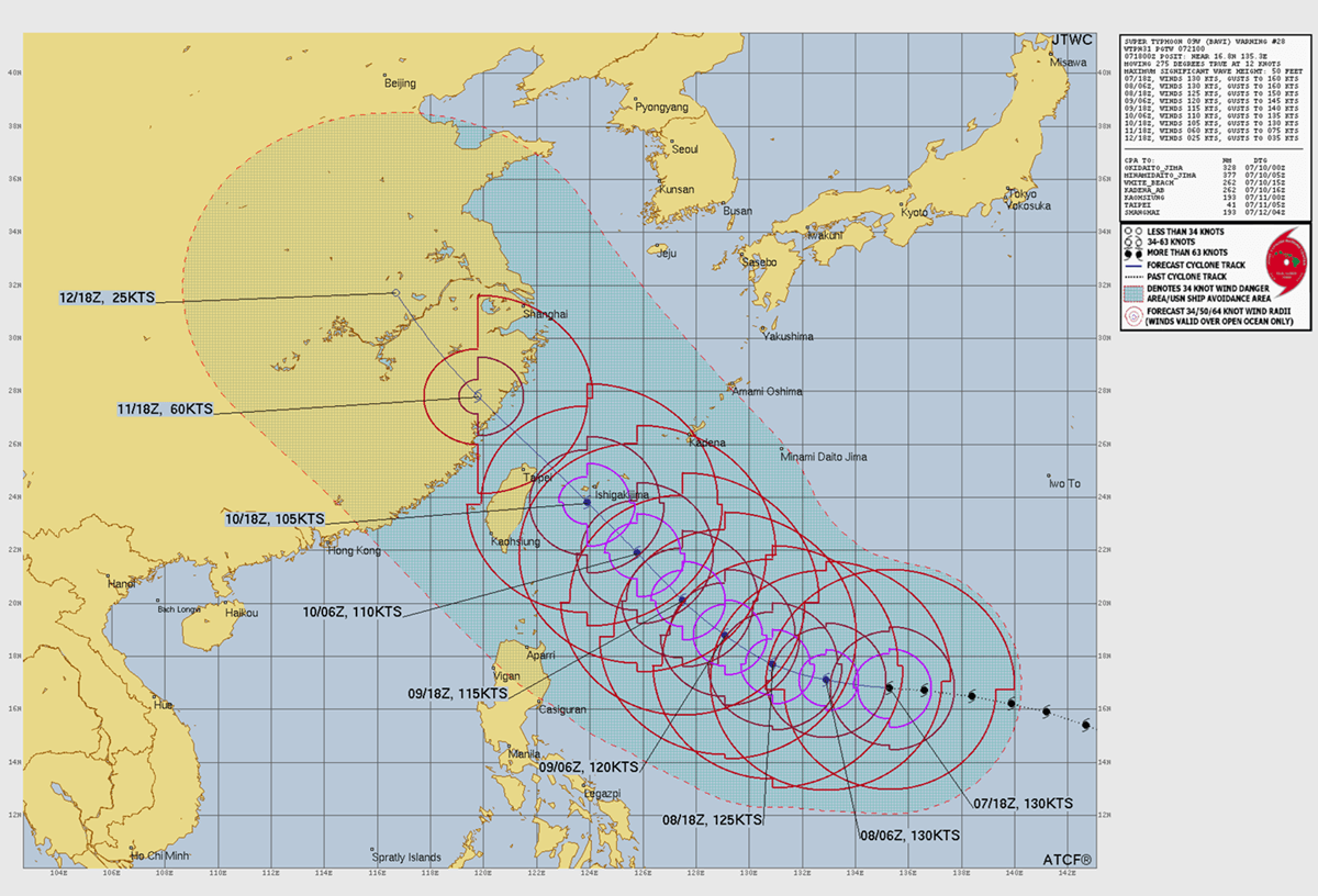
As of the latest tracking data, Bavi continues its relentless westward trajectory across the Philippine Sea. Meteorologists expect the storm to maintain its high-end intensity as it approaches the southern Japanese archipelago and northern Taiwan this coming Friday.
Supporting Data: The Science of Intensification
The intensity of Bavi is reflected in the latest Advanced Dvorak automatic satellite analysis, which provides a quantitative estimate of a tropical cyclone’s strength. With estimated peak winds of 135 knots and a Dvorak intensity rating of 6.8, the storm is operating at the upper echelon of tropical cyclone classification.
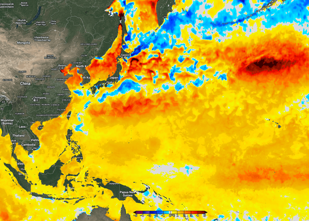
The Role of Anomalous Sea Temperatures
A deep dive into the oceanographic data reveals why Bavi has become so formidable. Sea surface temperatures across the western tropical Pacific are currently 2–3°C above the long-term average for early-to-mid July. In some areas near the coasts of China and Taiwan, these anomalies are even more pronounced, reaching 4°C above average.
This thermal energy increases the dew point and raises the potential for volatile, convective thunderstorm activity. When a tropical cyclone moves over such "charged" water, it consumes this energy, facilitating the rapid pressure drops observed in Bavi’s core.
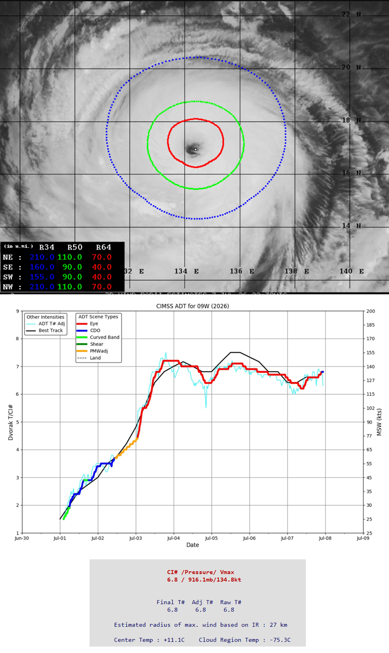
Symmetrical Expansion
Unlike many smaller, more concentrated typhoons, Bavi displays a high degree of symmetry. Tropical-storm-force winds extend up to 110 miles from the center, while the most intense, destructive winds are contained within a 60-70 mile radius of the eye. This wide wind field means that even if the eye does not make a direct landfall, the damage radius will be vast, affecting coastal infrastructure and maritime shipping lanes across a significant portion of the Philippine Sea.
Historical Context: Guam and the Legacy of "Typhoon Alley"
Guam’s geography has made it a sentinel for Pacific storms for generations. The island’s architecture tells the story of its resilience. Following the devastating Typhoon Karen in 1962, which leveled the majority of the island’s wooden structures, Guam underwent a massive transformation. Today, it is widely referred to as a "concrete island," with building codes strictly enforced to withstand the extreme pressures of the typhoons that frequently traverse this stretch of the Pacific.
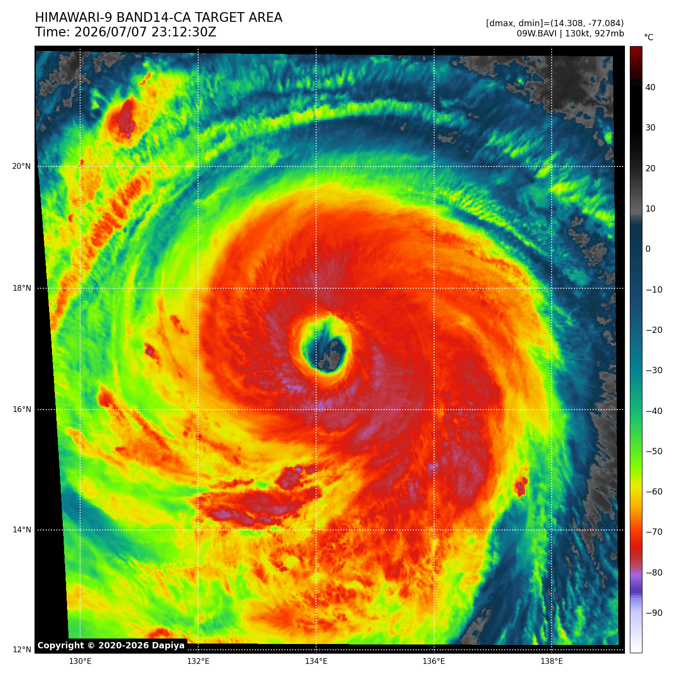
Bavi serves as a stark reminder of why these measures were necessary. When compared to historical giants like Typhoon Paka (1997) or Typhoon Pongsona (2002), Bavi stands out for its speed of intensification, a characteristic that modern climate models are increasingly flagging as a trend in a warming world.
Official Weather Advisory and Forecast
The current weather advisory remains critical: the storm is expected to maintain Category 4 to 5 status through Friday. While the most intense wind core may narrowly miss the densely populated urban centers of northern Taiwan, the secondary impacts are likely to be historic.
Rainfall and Flooding
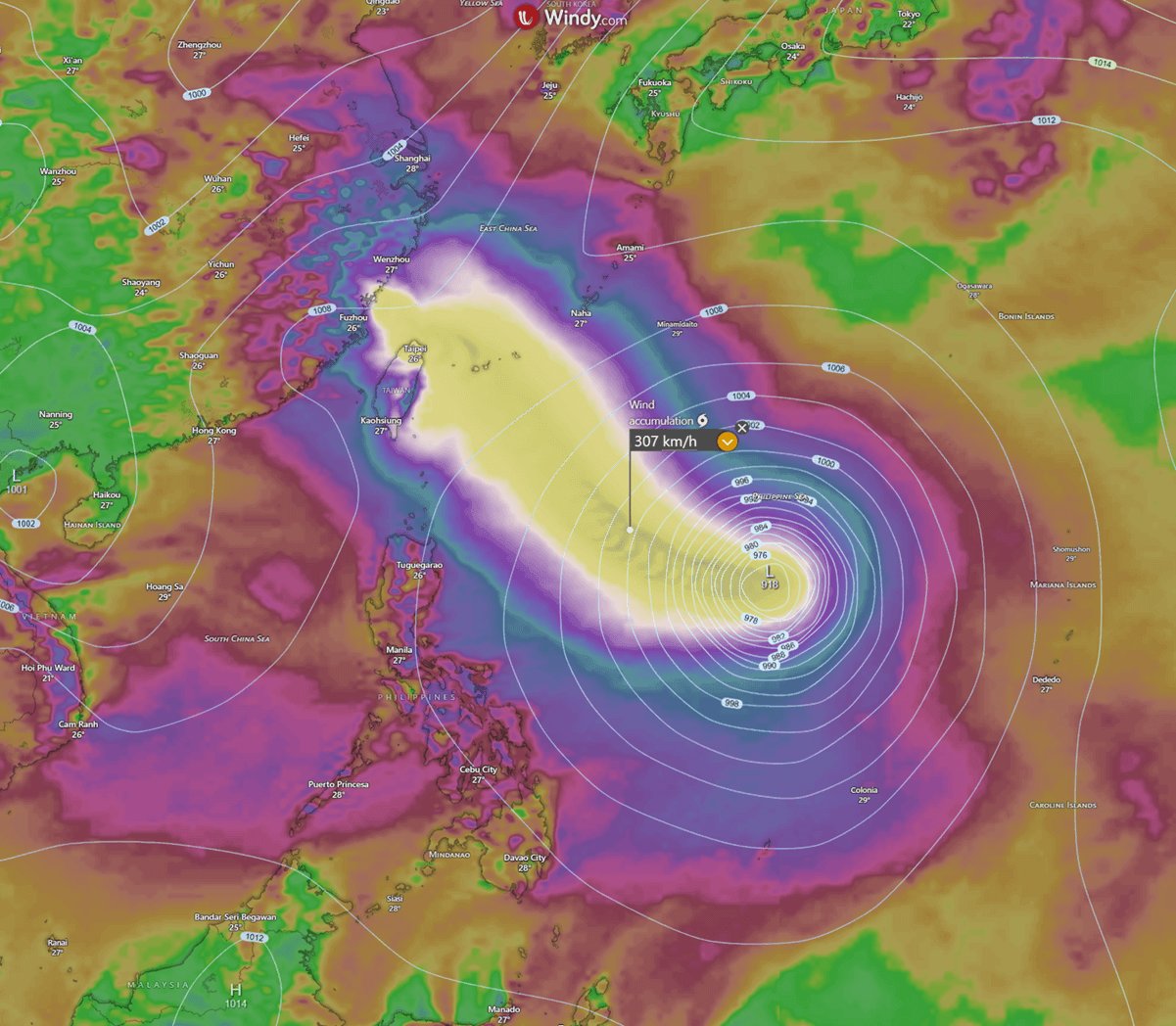
The most alarming forecast involves rainfall accumulation. Meteorologists are predicting that as Bavi interacts with the mountainous topography of Taiwan, it could dump between 600 mm and 1,000 mm (approximately 24 to 40 inches) of rain within a 48-hour period. In mountainous regions, this volume of water is almost certain to trigger life-threatening debris flows and catastrophic flash flooding.
Wind and Storm Surge
Coastal communities in southern Japan—specifically the islands of Ishigaki and Miyakojima—are braced for the arrival of the storm’s outer bands on Friday. These islands face a high risk of storm surges, where low atmospheric pressure "pulls" the ocean surface upward, creating a wall of water that, when pushed by 150+ mph winds, can inundate coastal defenses.
Implications for the Region
The implications of Super Typhoon Bavi are wide-reaching, affecting everything from local emergency preparedness to global supply chain logistics.
- Infrastructure Resilience: The ability of Taiwan’s electrical grid and maritime infrastructure to handle such an intense rainfall event will be tested. Given the scale of the storm, power outages are expected to be widespread.
- Economic Impact: With the storm tracking toward the Chinese mainland by Saturday, major manufacturing and shipping hubs will likely experience significant downtime. The interruption of port activities and the potential for flooding in low-lying industrial zones could have ripple effects on regional trade.
- Climate Adaptation: The rapid intensification of Bavi from a minor system to a Category 5 monster in less than 48 hours highlights the urgent need for improved, real-time satellite monitoring and predictive modeling. As ocean temperatures rise, these "explosive" storms are becoming more frequent, necessitating a re-evaluation of disaster risk reduction strategies in the Pacific Rim.
Conclusion
As Super Typhoon Bavi continues its path, the focus remains on the safety of the millions of people in its projected path. While the storm is expected to undergo a gradual weakening phase as it encounters cooler waters and higher wind shear near the Chinese coast on Saturday, it will remain an extremely dangerous system until it fully dissipates.
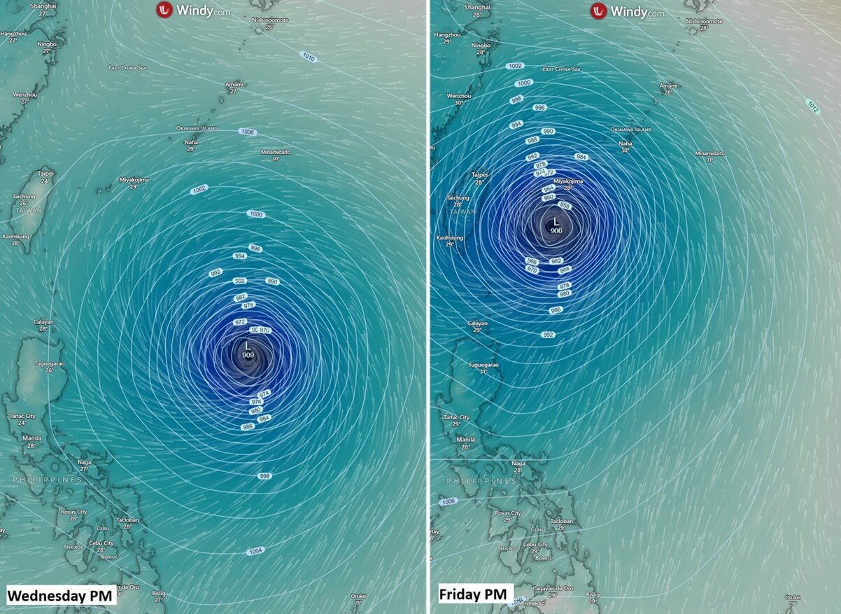
Authorities in Taiwan, Japan, and China have issued urgent warnings, urging residents to secure property, prepare emergency kits, and adhere to evacuation orders. The "monstrous" nature of Bavi—both in its size and its intensity—serves as a reminder that in the face of such natural force, preparedness remains the only effective defense. The global meteorological community will continue to monitor the system using satellite data from platforms like Windy and Tropical Tidbits, providing real-time updates as this historic storm nears its final phase.