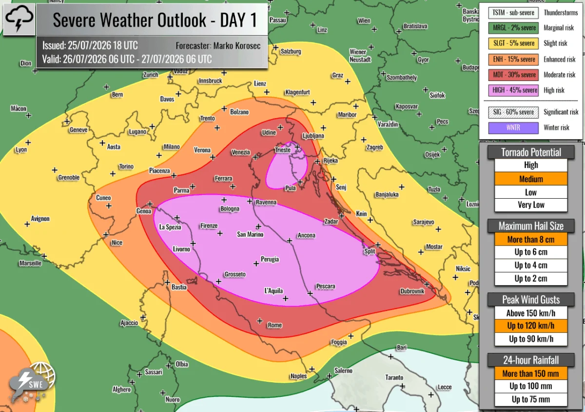
Valid Period: July 26, 2026, 06:00 UTC – July 27, 2026, 06:00 UTC
Issued by: Severe Weather Europe
Lead Forecaster: Marko Korosec
Executive Summary: A Continent Under Threat
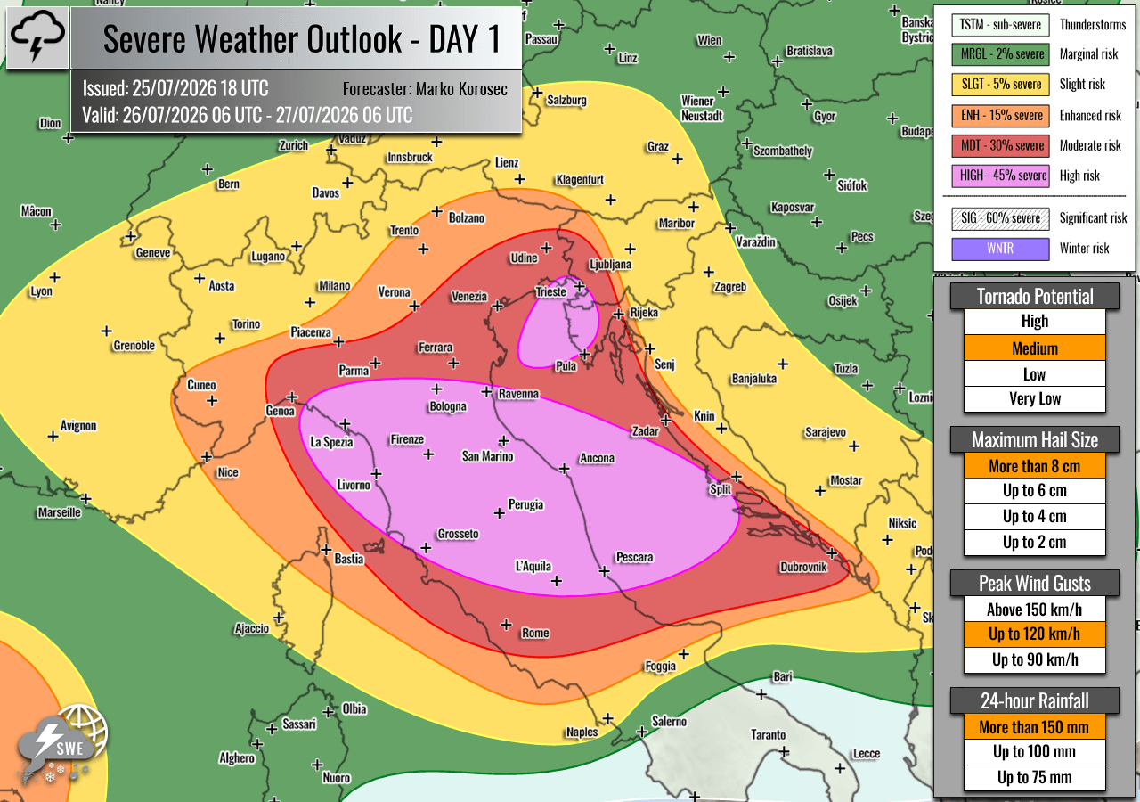
A dangerous and highly volatile meteorological setup is rapidly evolving across the European continent, centered primarily on the north-central Mediterranean and the Adriatic Sea. As of July 26, 2026, a significant severe weather outbreak is underway, characterized by a potent collision between extreme thermal instability and intense atmospheric shear. Forecasters have issued "HIGH" and "MDT" (Moderate) risk alerts for portions of Italy and the Adriatic region, signaling the potential for giant hail, destructive wind gusts, tornadoes, and catastrophic flash flooding.
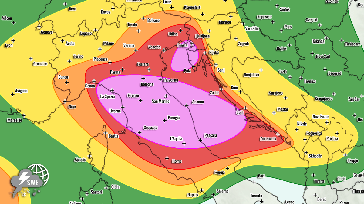
The synoptic situation involves a deep, stationary upper-level low positioned over Northern Europe, flanked by powerful blocking Highs over the North Atlantic and Russia. This configuration has effectively funneled a secondary wave of energy across the Alps, creating a prime environment for convective explosion as it enters the warm, moisture-laden air of the Mediterranean basin.
Synoptic Overview: The Mechanics of the Storm
The atmospheric machinery behind this event is complex and highly energetic. The primary driver is a deep, large-scale trough anchored over Northern Europe. This system is effectively "blocked," preventing the typical eastward progression of weather patterns and forcing energy to spill southward into the Mediterranean.
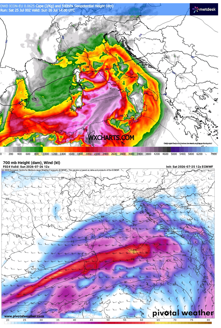
As this secondary wave traverses the Alps, it is encountering an environment characterized by extreme heat—a byproduct of an ongoing Mediterranean heatwave. Surface temperatures and dewpoints have surged, creating convective available potential energy (CAPE) values ranging from 2,000 to over 3,000 J/kg over the Tyrrhenian, Ligurian, and central Adriatic Seas. When this instability meets the strong mid-level jet stream associated with the passing wave, the result is "explosive" cyclogenesis and convective development.
At the surface, a secondary low-pressure system has formed in response to the upper-level forcing. This has triggered a frontal system that is currently sweeping from west to east, acting as a "trigger mechanism" that will force the unstable air masses to rise rapidly, forming the severe, long-lived storm clusters predicted for the coming 24 hours.
Chronology of the Outbreak: Sunday, July 26
The progression of this event is categorized by three distinct phases of intensification:
Early Morning to Midday:
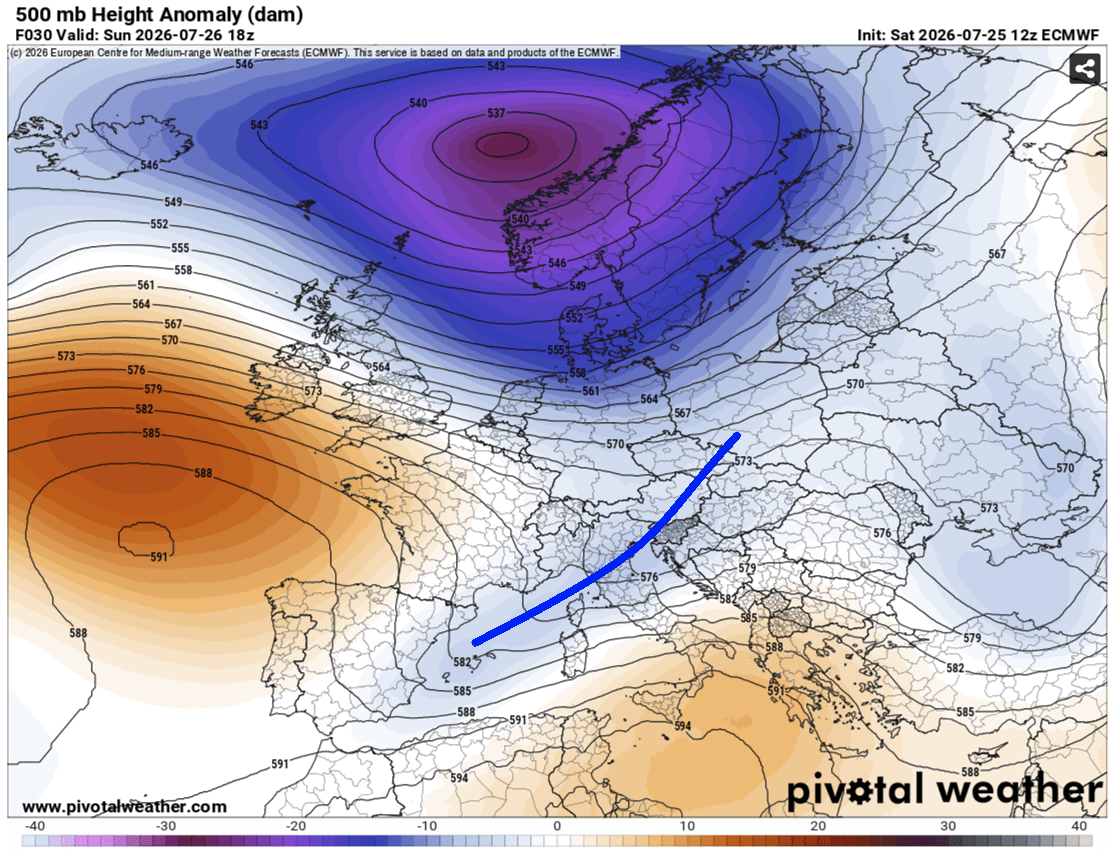
The outbreak commences in the Ligurian Bay. As the frontal system hits the rugged terrain of the Apennine Mountains, the air will be forced upward, initiating the development of intense supercell storms. These early cells are expected to be particularly dangerous, as they will be moving into an environment with high precipitable water (PWAT) values between 45–60 mm.
Afternoon Intensification:
As the day progresses, the focus shifts toward the Adriatic Sea. The "nose" of a low-level jet stream will move across the North Adriatic, creating stationary convergence zones. Here, meteorologists expect "training" thunderstorms—a phenomenon where successive storms pass over the same geographical location. This is the primary driver of the flash flood threat, as high-resolution models suggest rainfall accumulations could reach the 100–200 mm range within a 6–12 hour window.
Evening and Overnight:
The storm clusters are expected to coalesce into a larger, organized convective system. As they traverse the Adriatic toward the Western Balkans, the threat profile remains high, with the focus shifting toward damaging straight-line winds and potential nocturnal tornadoes. The system is expected to persist through the early hours of Monday, July 27, before weakening as it moves further inland.
Regional Breakdown: Areas at Maximum Risk
The Italian Peninsula and Central Adriatic
A "HIGH" risk classification has been designated for central and northern Italy, extending into the central Adriatic. This zone faces the full spectrum of severe weather: giant hail (exceeding 10 cm in diameter), wind-driven debris, and intense supercells capable of producing tornadoes. The proximity to the Apennines adds an extra layer of danger, as mountainous terrain can often intensify wind speeds and concentrate rainfall.
Istria, Croatia, and Southwestern Slovenia
A secondary "HIGH" risk area targets the northeast Adriatic, specifically the Istrian peninsula and parts of southwestern Slovenia. This region is currently at the peak of its summer tourism season. The threat here is dominated by the potential for stationary or slow-moving storms, which could lead to localized, life-threatening flash flooding in coastal towns and tourist infrastructure. Waterspouts are also a significant concern as storms move off the coast into the Adriatic.
Secondary Risk Zones: Austria, Switzerland, and the Western Mediterranean
Surrounding the high-intensity core, "MDT" (Moderate) and "ENH" (Enhanced) risks have been issued for:
- Western/Central Slovenia & West-Central Austria: Risks include large hail and wind gusts, though total storm coverage is expected to be lower than in the coastal regions.
- Northeast Spain & Balearic Islands: Isolated but potent severe storms are expected to form, carrying risks of large hail and damaging winds.
- Southwestern Russia: A separate, large-scale "ENH" risk has been identified. Here, the atmosphere is primed for discrete, supercellular activity with a notable tornado threat due to enhanced low-level shear.
Supporting Data: Why This Outbreak is Exceptional
The severity of this event is not merely based on speculation but on high-resolution atmospheric modeling provided by institutions including Meteoadriatic, Wxcharts, and PivotalWeather.
- Instability (CAPE): Values exceeding 3,000 J/kg represent a high-octane fuel source for thunderstorms.
- Wind Shear: The presence of a strong mid-level jet creates the "tilt" required for supercell longevity. This allows storms to maintain their structure, prevent them from "choking" on their own downdrafts, and sustain them for hours.
- Helicity: The low-level wind shear and storm-relative helicity levels are specifically favorable for mesocyclone rotation, which is the precursor to tornadogenesis.
The high PWAT (Precipitable Water) levels, which indicate the total moisture in the atmospheric column, are effectively at the top end of the scale for this region. This is why forecasters are warning of "torrential and excessive" rainfall rather than standard heavy rain.
Official Implications and Safety Guidance
The combination of a peak summer tourism season and a severe weather outbreak creates a high-stakes safety environment.
Implications for Travelers:
- Coastal Hazards: Tourists in Istria and coastal Italy should monitor local weather alerts continuously. Flash floods in coastal basins can happen with little warning, and waterspouts can move onshore rapidly.
- Infrastructure: Power outages are highly likely given the predicted "severe damaging winds." Transportation networks, particularly coastal roads and ferry services in the Adriatic, may face significant disruption.
Implications for Residents:
- Preparation: Residents in the "HIGH" risk zones should secure outdoor furniture and vehicles, as "giant" hail is capable of shattering windshields and causing significant structural damage to roofs.
- Flash Flood Awareness: Avoid low-lying areas, underground parking garages, or tunnels during the peak of the storms. If you are caught in a vehicle during torrential rain, do not attempt to drive through flooded roads.
A Note from the Forecaster:
The transition from a standard summer day to a violent severe weather event can happen in under an hour. Residents are urged to avoid complacency. While the "purple" highlighted areas represent the greatest danger, the surrounding "MDT" and "ENH" zones are still prone to significant, life-altering weather events. Please treat all incoming storm cells as potentially life-threatening until they have passed.
For the latest real-time updates and localized warnings, monitor your national meteorological service and the official channels of Severe Weather Europe.