By Mika Rantanen
Published: August 10, 2026
For many residents across Finland, the summer of 2026 has felt curiously understated. In a decade increasingly defined by record-breaking heatwaves and prolonged droughts, the current season has offered a starkly different experience: one of volatility, variability, and—perhaps most surprisingly—a return to historical averages. While the global climate continues its long-term warming trend, this summer has served as a gentle reminder of the natural oscillations inherent in Nordic weather patterns.
The State of the Season: Moving Beyond the "Heat Trap"
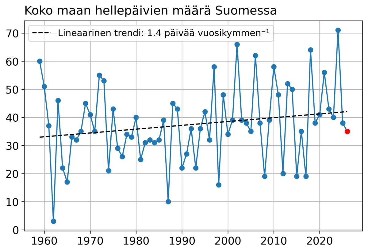
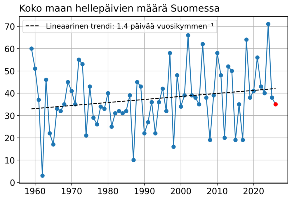
As of August 10, 2026, the cumulative count of "hellesäivä" (days where the maximum temperature hits at least 25.1°C) stands at 35. To the casual observer, this figure might seem substantial, but in the context of recent climate history, it represents the lowest tally in nine years.
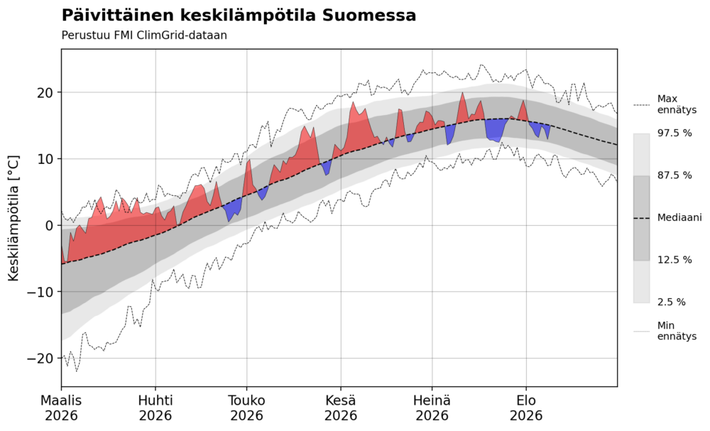
While the spring of 2026 began with temperatures that were persistently higher than the long-term average, the narrative shifted dramatically after the beginning of June. Since then, the weather has been characterized by rapid fluctuations. We have moved away from the prolonged, stagnant high-pressure systems that have plagued recent summers, instead experiencing a "normal" cycle of shifting air masses.
Despite the subjective feeling that this summer has been "cool," data tells a more nuanced story. The average temperature for the entire season is currently tracking very close to the long-term statistical mean. The perception of coolness is likely a byproduct of the lack of extreme, back-to-back heat spikes that have become "the new normal" in previous years.
A Chronology of Climatic Swings
The summer’s volatility was perhaps most evident in mid-July. On July 23, the national average temperature plummeted to a mere 12.5°C—a figure that flirted with historical cold records for that specific date. This sharp dip serves as a prime example of the meteorological "seesaw" that has defined the last two months.
While the winter and spring months saw temperatures occasionally breaking records, the post-March period has been remarkably well-behaved. The lack of sustained heat records is a significant deviation from the patterns seen in 2023, 2024, and 2025.
The Statistical Discrepancy
An interesting point of friction in this year’s data collection involves the official counts provided by the Finnish Meteorological Institute (FMI). While our internal calculations place the heatwave day count at 35, the official FMI statistics list 34. This discrepancy arises from the technical methodology used to record maximum temperatures.
At the Porvoo Harabacka station, a maximum of 25.1°C was recorded on June 22. However, because the measurement occurred immediately after the 18 UTC cutoff on June 21, it was logged into the subsequent day’s records. While official FMI statistics use the "daytime" maximum (06–18 UTC), our tracking uses the full 18–18 UTC cycle. This nuance underscores the importance of methodology in climate reporting—small shifts in measurement windows can lead to different interpretations of the summer’s intensity.
Supporting Data: The Nine-Year Low
To understand the rarity of this summer, one must look at the trajectory of the last three decades. The median number of heatwave days in Finland over the past 30 years is 39. With 35 days currently logged and only a few weeks of summer remaining, it is highly probable that the final count will settle between 35 and 40.
This would officially mark the least "hot" summer since 2017. While the long-term trend remains firmly upward—indicating that, on a multi-decadal scale, Finland is indeed warming—the year 2026 serves as a statistical outlier. It is a reminder that climate change does not move in a straight, uninterrupted line; rather, it manifests through a warming baseline upon which natural weather variability is superimposed.
The "Heat Dome" and the European Divide
While Finland has enjoyed a relatively temperate summer, the rest of Europe has not been so fortunate. A recurring theme this year has been the geographical division of heat. Western, Southern, and parts of Central Europe have been battered by persistent, intense heatwaves, while Finland and the Fennoscandian region have remained largely on the periphery of these systems.
The Role of Atmospheric Blocking
The primary driver behind this disparity is the positioning of high-pressure systems in the upper atmosphere. Meteorologists have observed a recurring "heat dome"—a high-pressure ridge—that has locked itself over Western Europe and the British Isles.
In this configuration, the jet stream is forced to bend, creating a "blocked" weather pattern. Because this pattern is stagnant, the heat is trapped in a loop, allowing the same regions to experience wave after wave of extreme temperatures. While the heat has occasionally nudged north toward Scandinavia, it has lacked the intensity and longevity to establish itself, usually dissipating before it could cause a prolonged heat event.
Implications: The El Niño Connection
Why has this specific atmospheric configuration been so persistent? One potential "driver" under investigation is the exceptionally strong El Niño event that intensified throughout the summer of 2026, reaching record-breaking levels.
El Niño is a global climate phenomenon that significantly alters atmospheric circulation. Historical records indicate that during El Niño summers, Europe often experiences a distinct east-west temperature gradient. Specifically, Western and Central Europe tend to warm significantly as the atmospheric circulation patterns shift, while Finland and Eastern Europe often find themselves in a region of more unstable, cooler, and wetter weather.
This year’s setup aligns closely with the expected impacts of such a strong El Niño. While it is impossible to attribute the entire summer’s climate to a single factor, the correlation is too significant to ignore. The persistent "blocking" pattern in Western Europe and the relative relief in the North are textbook characteristics of the teleconnections triggered by tropical Pacific temperature anomalies.
Looking Ahead: A Measured Outlook
As we move into the final weeks of August, the short-term forecasts do not indicate any major or sustained heatwaves for Finland. While there may be brief pulses of warm air resulting in a few additional heatwave days, the record-breaking, multi-week "scorcher" scenarios that have haunted previous summers are not currently on the horizon.
Ultimately, the summer of 2026 will likely be remembered not as a year of climate extremes, but as a year of "equilibrium." It provides a vital case study for climate scientists: a year where the long-term warming trend was temporarily masked by favorable atmospheric positioning and global ocean-atmosphere interactions.
As research into the 2026 El Niño impact continues, this summer will stand as a valuable data point. It reminds us that while the global climate is shifting, regional weather remains a complex tapestry of local geography, global circulation, and historical luck. For the residents of Finland, it has been a summer of respite—a rare, temperate interlude in an era of rapid environmental change.