As the final days of August 2026 approach, Europe finds itself gripped by its sixth major heatwave of the season. A formidable "heat dome"—a persistent, high-pressure blocking system—has anchored itself over the Central Mediterranean and Southern Europe, creating a meteorological furnace that is pushing temperatures to dangerous, record-challenging levels. Meteorologists warn that this event is not merely a transient spike in weather but a structural atmospheric anomaly that threatens human health, agricultural stability, and energy grid integrity across the continent.
The Atmospheric Engine: Anatomy of a Heat Dome
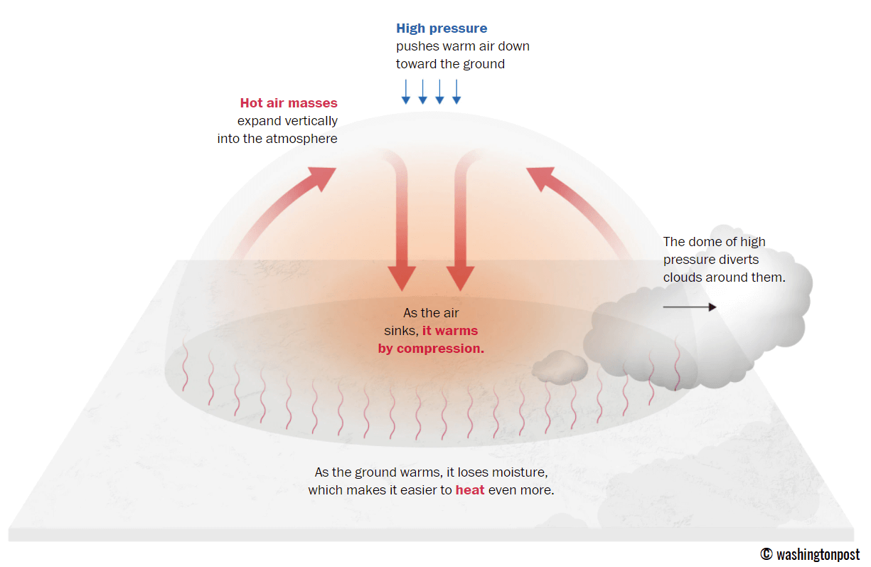
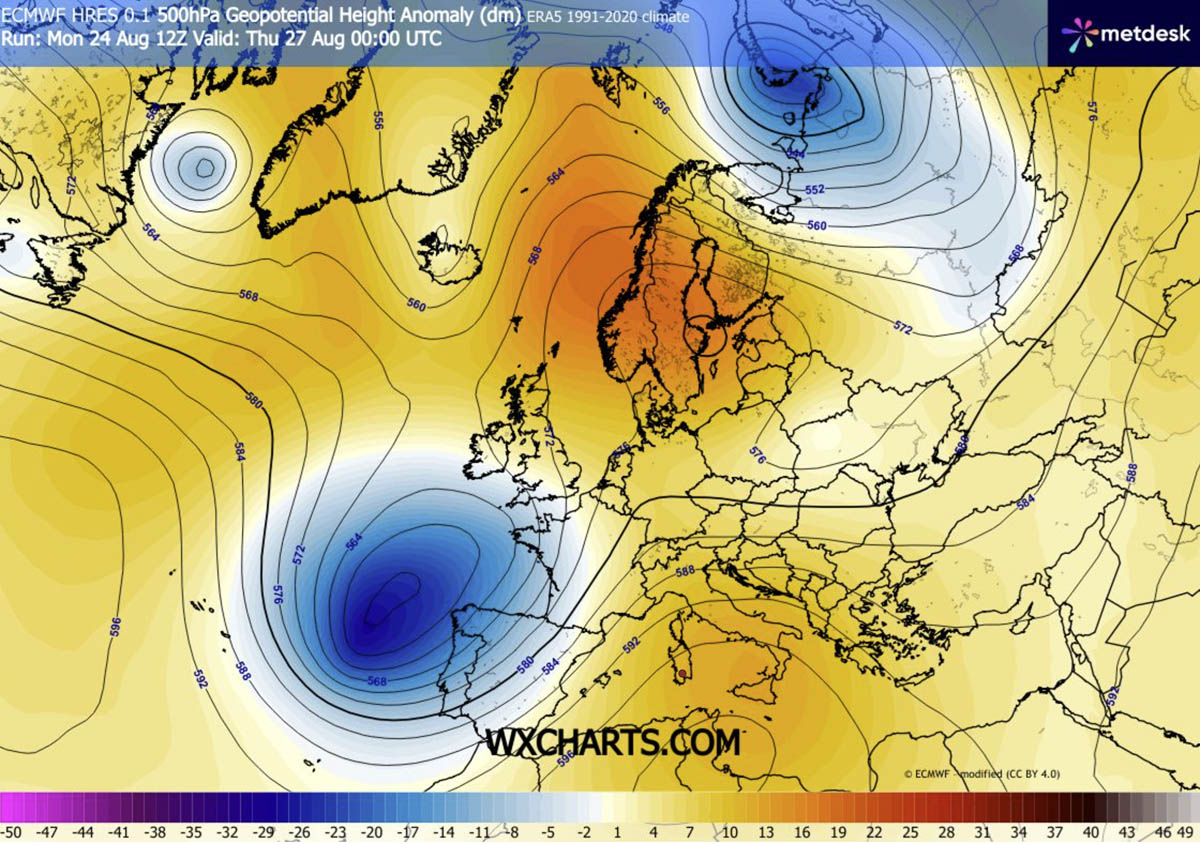
At the heart of this crisis is a stubborn high-pressure ridge. In meteorological terms, a heat dome functions as a atmospheric "lid" on a boiling pot. When a large area of high pressure parks itself over a region, it creates a feedback loop: air from the upper atmosphere sinks toward the ground, and as it descends, it compresses and warms adiabatically. This process traps existing heat at the surface, preventing the normal vertical mixing that would otherwise dissipate thermal energy.
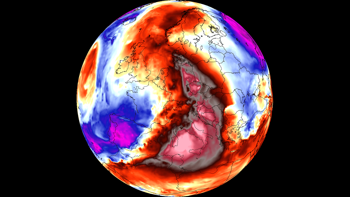
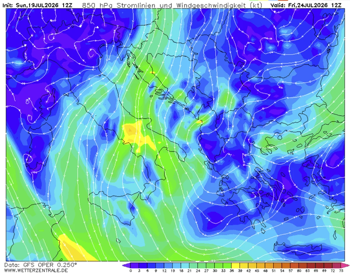
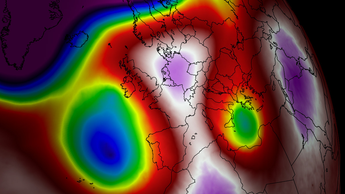
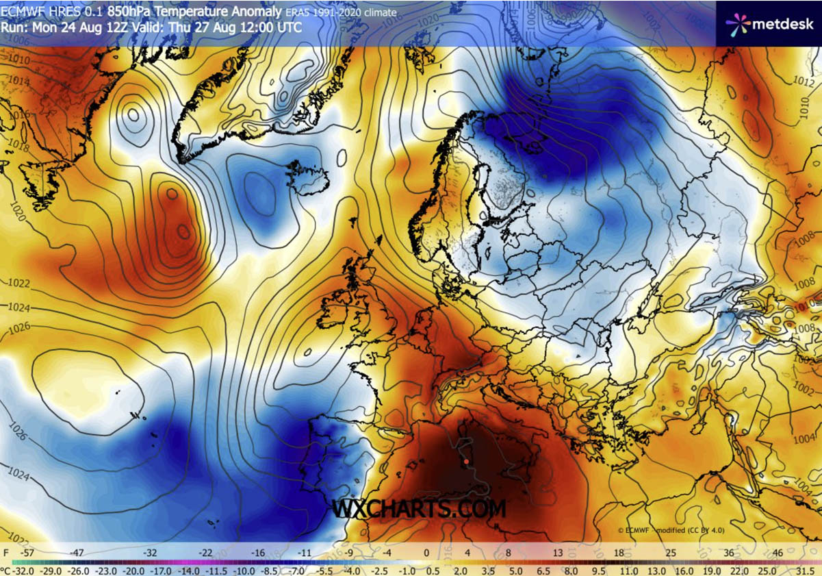
This specific event is being fueled by an influx of hot air from North Africa, which has been drawn northward by an unseasonably deep upper-level wave over the Bay of Biscay. The result is a prolonged thermal surge where temperatures are projected to climb between 38°C and 43°C (100°F–109°F) in low-lying river basins and agricultural plains. These conditions are exacerbated by dry continental winds that accelerate the depletion of soil moisture, creating a dangerous precursor to wildfire development.
Chronology of the Thermal Surge
The progression of this heatwave is characterized by its intensity and the geographic scale of its impact.
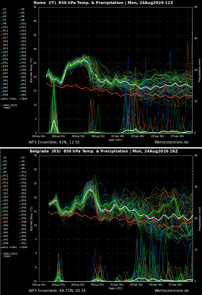
- Mid-Week Peak: Throughout the middle of this week, the primary heat core is concentrated over Italy and the Central Mediterranean. By Thursday, as the ridge expands, the thermal anomaly is expected to reach its zenith, with southern and central Balkan nations, including Serbia, Croatia, and Bosnia, experiencing peak temperatures.
- Expansion to Central Europe: On Thursday and Friday, the plume of hot air is forecast to breach the Alps, pushing temperatures in Germany and neighboring Central European states into the low-to-mid 30s°C.
- The Weekend Shift: As the heat dome elongates and moves eastward, the intensity will shift toward Poland and western Ukraine. Conversely, parts of Western Europe, including France and the Benelux region, may begin to see relief as cooler maritime air from the Atlantic filters in.
- The "Tropical Night" Crisis: Perhaps the most concerning aspect of this chronology is the lack of nocturnal cooling. Nighttime temperatures are expected to remain trapped between 22°C and 26°C. These "tropical nights" deprive the human body of the critical recovery window needed to dissipate heat, leading to cumulative physiological stress.
Supporting Data and Meteorological Projections
Data from current forecast models indicate that the intensity of this heatwave is significantly above the long-term climatic average. Across the affected regions, temperatures are currently running 12°C to 16°C above typical late-August norms.
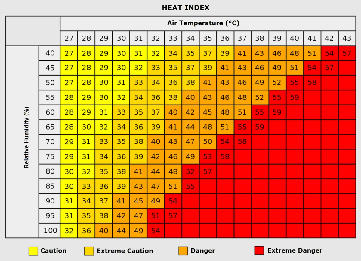
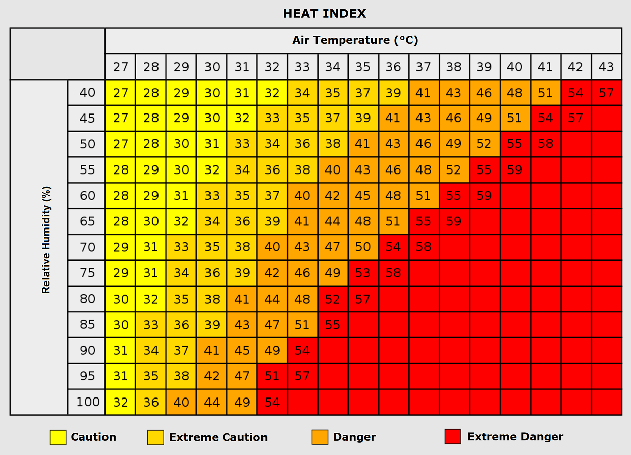
The use of the "Heat Index" is critical in assessing the true danger of this event. While thermometers may show 35°C, the combination of humidity—often exceeding 60–80% in valley regions—can result in "feels-like" temperatures nearing 50°C. These conditions push the human body to its thermoregulatory limits, significantly increasing the risk of heat exhaustion and heat stroke.
Furthermore, the synoptic setup is creating a secondary, yet equally volatile, hazard. The sharp pressure gradient between the massive high-pressure ridge over the Mediterranean and the deep low-pressure wave over Western Iberia is acting as a catalyst for severe weather. Specifically, across France and the Western Alps, the confluence of high convective available potential energy (CAPE)—estimated between 3,000 and 5,000 J/kg—and strong vertical wind shear suggests an impending outbreak of violent supercell thunderstorms. Residents in these areas should prepare for the potential of giant hail, damaging wind gusts, and localized flooding.
Implications for Public Health and Infrastructure
The implications of such a sustained heat event are multifaceted and profound.
Human Health Impacts
Public health authorities are on high alert. Vulnerable populations—the elderly, children, and those with pre-existing cardiovascular or respiratory conditions—are at the highest risk of mortality. The phenomenon of "tropical nights" means that internal body temperatures do not have a chance to return to baseline overnight, which has been clinically linked to an increase in heart attacks and strokes during prolonged heatwaves.
Furthermore, the socio-economic dimension cannot be ignored. Individuals residing in urban environments with high concentrations of heat-absorbing materials, such as concrete and asphalt, suffer disproportionately. These "urban heat islands" can remain several degrees hotter than surrounding rural areas, turning residences into death traps for those without access to modern climate control.
Energy Grid and Economic Stability
As temperatures soar, energy demand skyrockets. The reliance on air conditioning systems puts a massive strain on the European power grid, increasing the risk of localized brownouts. This is particularly problematic in a season where energy conservation is already a policy priority.
Agriculture is also facing a critical test. The combination of extreme heat and dry, gusty winds is desiccating crops, potentially leading to significant yield losses in corn, sunflowers, and vineyards across the Balkans and the Po Valley. These economic losses, combined with the costs of emergency response and healthcare, represent a multi-billion-euro impact on the European economy.
Official Responses and Safety Recommendations
While government agencies across the continent are coordinating localized warnings, the consensus among civil protection units is clear: the current situation requires extreme caution.
- Hydration and Exposure: Authorities recommend that all outdoor labor, including farming and construction, be restricted to the early morning or late evening hours. Hydration must be prioritized, even in the absence of thirst.
- Infrastructure Checks: Utility companies in Italy and the Balkans have been placed on standby to manage potential grid surges. Citizens are encouraged to moderate their usage of heavy appliances during the peak afternoon hours (13:00 to 18:00).
- Wildfire Vigilance: Given the dry conditions, forest and park services have escalated fire risk warnings. In areas like the Mediterranean coastline and the Balkan river valleys, any source of ignition—such as cigarettes or improperly extinguished campfires—could trigger rapid-fire spread.
- Weather Preparedness: For those in regions flagged for potential storm outbreaks, such as Eastern France, the advice is to monitor local radar closely. When a heat dome breaks, it often does so with violent instability, turning a heat emergency into a wind and hail emergency in a matter of minutes.
Looking Forward: A New Normal?
This sixth heatwave of 2026 serves as a sobering reminder of the changing climate dynamics in Europe. The frequency and intensity of these "blocking high" events suggest that the atmospheric circulation patterns over the continent are undergoing a significant shift. As we transition into early September, meteorologists note that the long-range outlook remains dynamic, with trends suggesting that warmth will linger well beyond the traditional end of summer.
As the continent endures this latest assault of heat, the focus remains on resilience. From the local municipal governments providing "cooling centers" to the international scientific community analyzing the interaction between the Atlantic maritime air and the Mediterranean heat dome, the lessons learned from this week will be vital for future adaptation. For now, the priority for millions remains the same: stay indoors, stay hydrated, and monitor the shifting skies as this latest heat dome begins its slow, eastward retreat.