As summer traditionally begins its retreat, Europe is currently facing an aggressive, late-season meteorological phenomenon that is shattering historical norms. A massive, high-pressure "heat dome" has established itself over the Mediterranean Basin, acting as a thermal trap that is expected to drive temperatures into the upper 30s and, in many localized areas, exceed the 40°C threshold. This intense heatwave, fueled by a deep-reaching plume of North African air, is poised to impact a vast swathe of the continent, including Spain, France, Italy, and the Balkan Peninsula, throughout the first half of September.
Main Facts: The Anatomy of a Late-Season Crisis
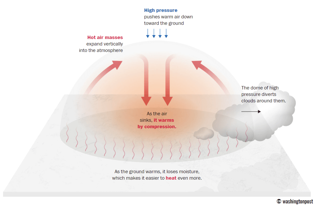
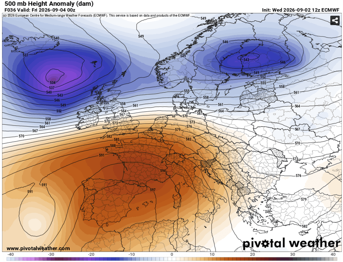
The current synoptic setup is dominated by a robust, blocking high-pressure system. Meteorologically, a "heat dome" functions much like a lid on a pressure cooker; the high-pressure ridge forces air to descend, which causes it to compress and heat up adiabatically as it approaches the surface. Because this system is remarkably stable, it is effectively stalling over the continent, preventing the movement of cooler, maritime air masses that would typically moderate temperatures as the calendar turns toward autumn.
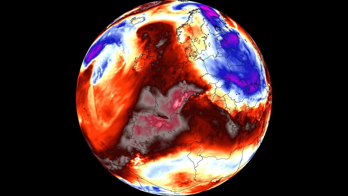
Key features of this event include:
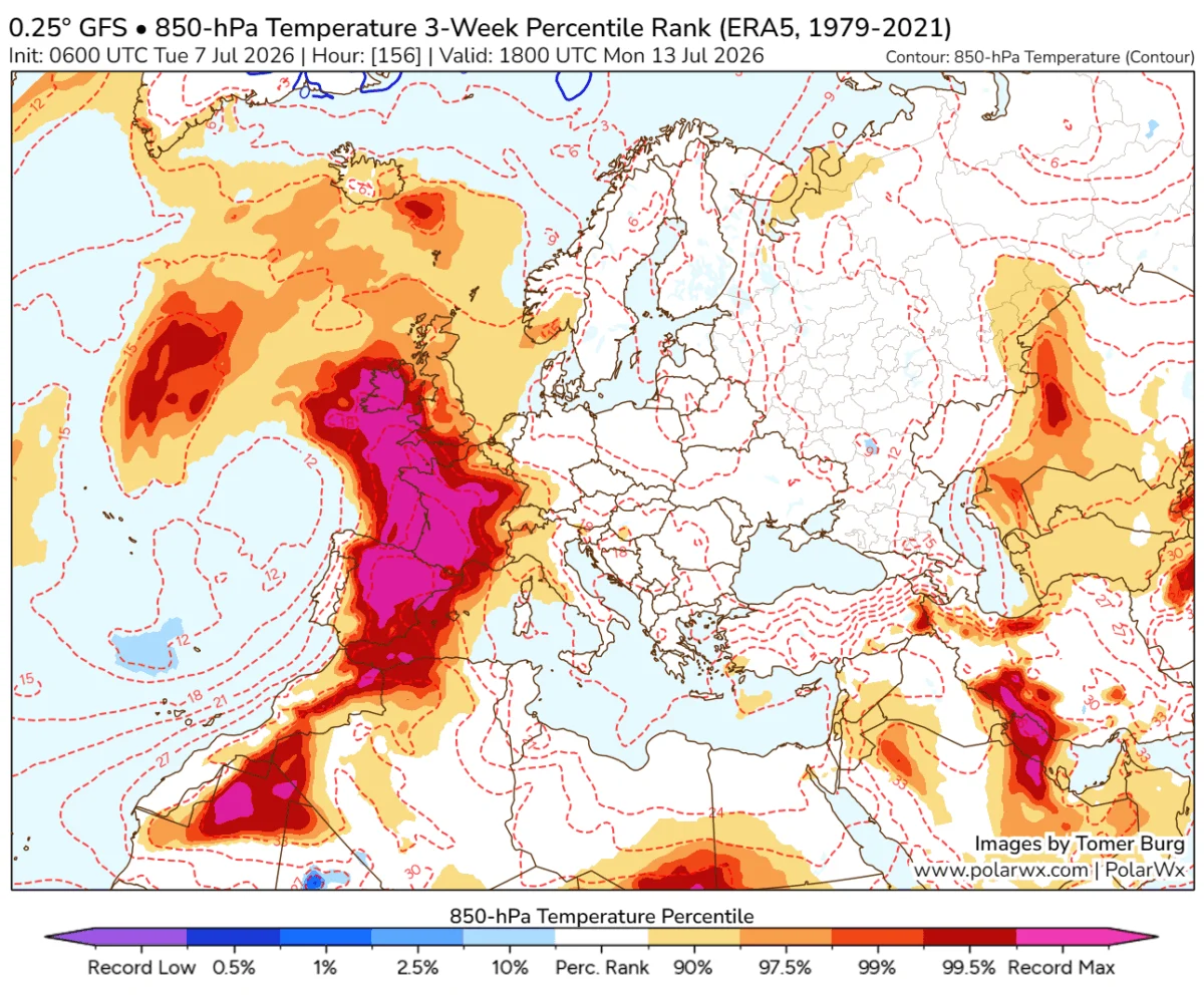
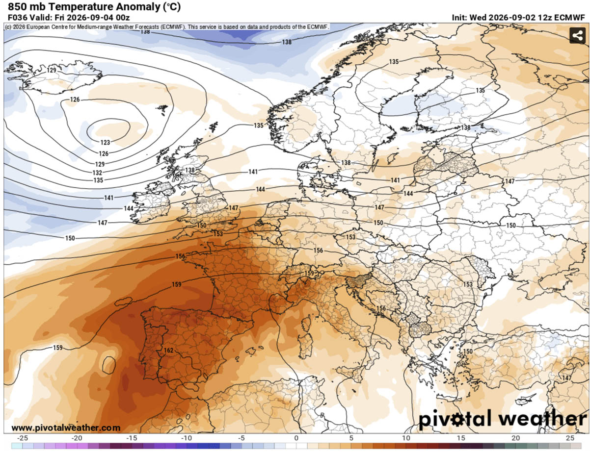
- Widespread Anomalies: Thermal anomalies at the 850 hPa level are significantly above seasonal averages, indicating a deep layer of warm air.
- Peak Intensities: Southern and central regions of the Iberian Peninsula, as well as parts of Italy, are bracing for temperatures between 38°C and 44°C.
- Nocturnal Persistence: Perhaps the most dangerous aspect of this heat dome is the lack of nighttime cooling. "Tropical nights," where temperatures refuse to dip below 22°C to 25°C, are expected to plague urban centers, denying residents the physiological recovery period necessary to withstand sustained high temperatures.
Chronology: A Multi-Day Expansion
The development of this heatwave follows a clear progression across the European map.
The Initial Surge (Thursday–Friday): The core of the heat dome is currently focused on the Iberian Peninsula and southwestern France. Residents in central and southern Spain and Portugal are experiencing the brunt of the initial spike, with temperatures climbing toward 44°C. The air mass is exceptionally dry, which, while reducing humidity, significantly elevates the risk of rapid-onset wildfires in parched vegetation.
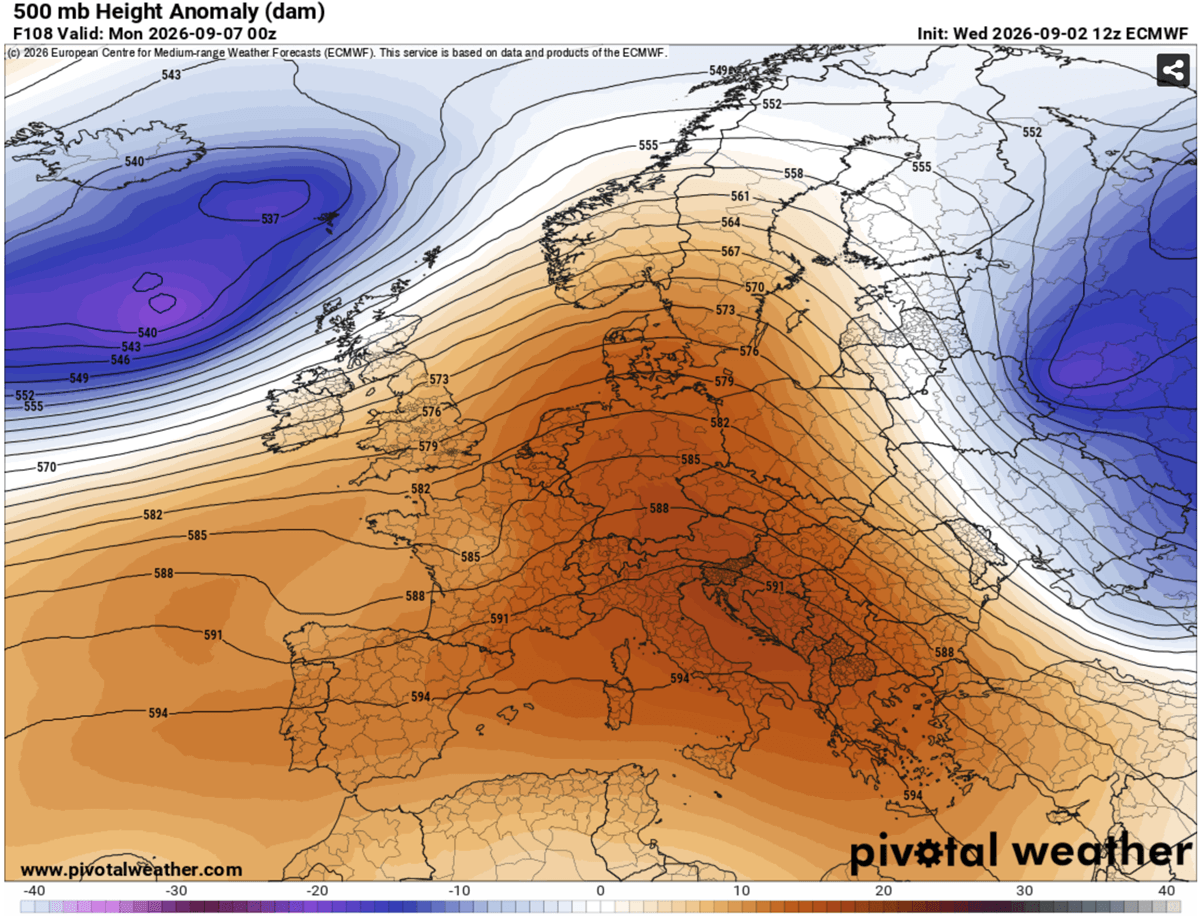
The Continental Spread (Saturday–Monday): As the weekend progresses, the ridge is forecast to expand northward and eastward. The focus of the extreme heat will shift toward the Po Valley in northern Italy, central France, and the Balkan states. By Sunday, the influence of the heat dome will be felt as far north as the southern United Kingdom, though the intensity there will be lower, with highs expected in the mid-to-upper 20s.
The Peak of the Event: Mid-next week marks the zenith of the heatwave for the Balkan Peninsula and central Italy. It is during this window that local records for early September could be challenged, as the high-pressure system reaches its maximum extent before the anticipated "pattern flip."
Supporting Data: Understanding the Thermal Anomalies
Meteorological models, including data from high-resolution global forecast systems, illustrate a clear disparity between expected seasonal averages and current projections. Surface temperatures are currently trending 10°C to 14°C above the long-term climatic norms for early September.
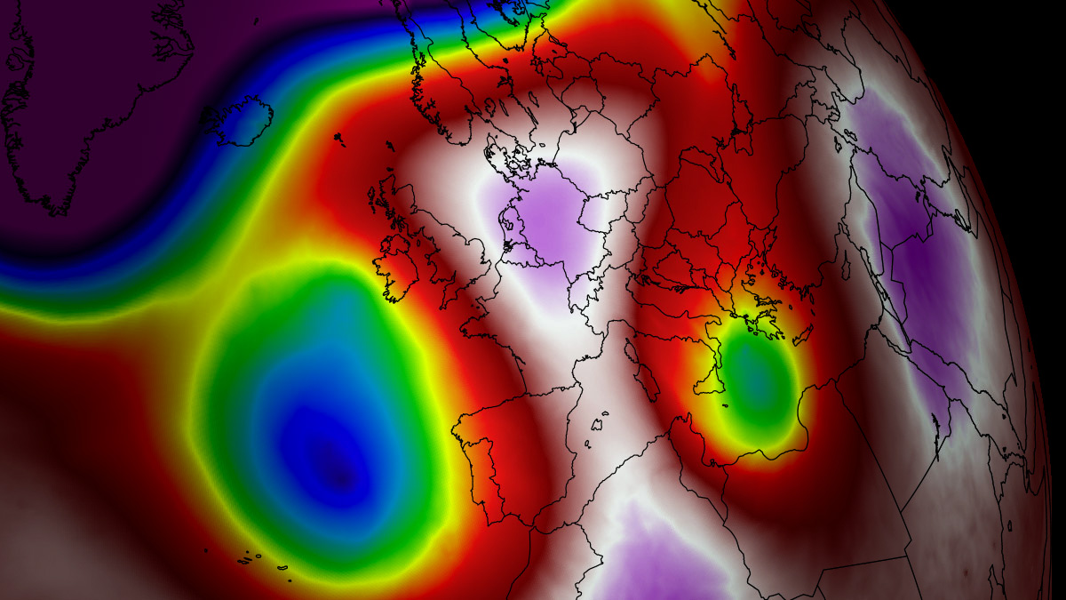
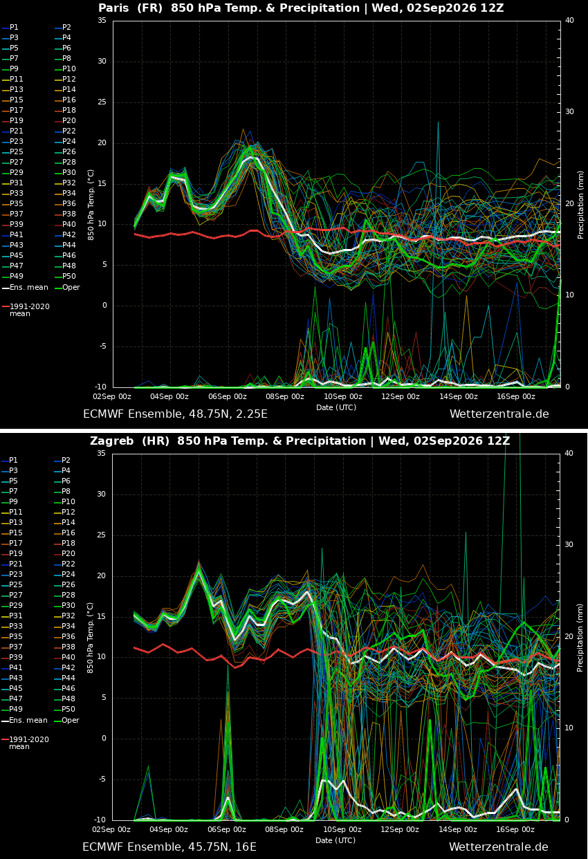
The heat dome is characterized by its stability. Schematic analysis of the omega-block pattern shows that the high-pressure core is being flanked by low-pressure systems in the North Atlantic, which, rather than disrupting the heat, are initially acting to reinforce the ridge by pulling further warm air from the south. The "meteogram" projections for major cities—such as Paris and Zagreb—indicate a sustained plateau of extreme heat, with no immediate sign of a break until the middle of the following week.
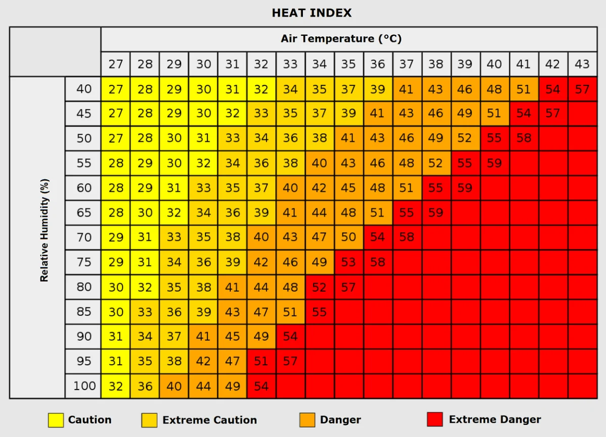
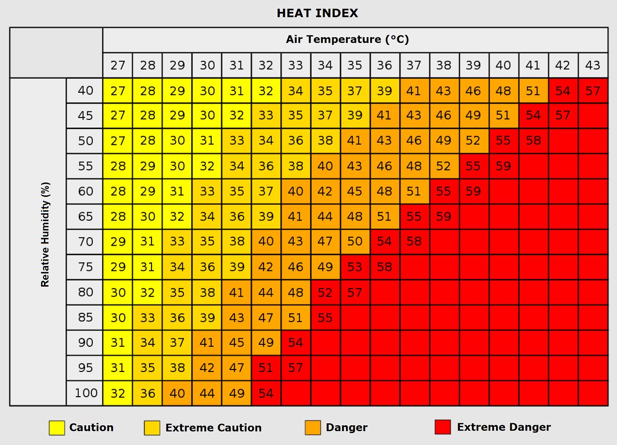
The reliance on the "Heat Index" becomes critical during this event. In regions where temperatures exceed 35°C, even moderate humidity levels can push the "perceived" temperature toward 50°C. This combination of heat and humidity effectively prevents human sweat from evaporating efficiently, drastically increasing the risk of heat-related illnesses for the general population.
Implications: Health, Infrastructure, and Environmental Risk
The socio-economic and public health implications of a September heatwave are profound. Unlike mid-summer heatwaves, for which infrastructure and society are often better prepared, a September event catches populations when fatigue from the summer months is already high.
Public Health Concerns
Medical professionals are particularly concerned about the impact on the elderly and those with chronic respiratory or cardiovascular conditions. The lack of nighttime cooling is a primary concern; when the human body is unable to lower its core temperature during sleep, the cumulative physiological strain can lead to heat exhaustion and, in extreme cases, fatal heat stroke.
Energy Grid Strain
As temperatures soar, demand for air conditioning and cooling systems is expected to hit peak levels. This places immense pressure on the European energy grid. The combination of high demand and the potential for decreased efficiency in power generation during extreme heat can lead to localized grid instability.
Wildfire Vulnerability
The prolonged duration of the heatwave is rapidly depleting soil moisture. Mountainous slopes and forested areas in Southern Europe, already suffering from an arid summer, are now at an elevated risk of spontaneous or easily ignited wildfires. The dry continental winds accompanying the heat dome act as a catalyst for fire spread, making fire prevention efforts critical.
Official Responses and Future Outlook
While regional governments have begun issuing heat-health warnings, the focus remains on personal mitigation: staying hydrated, avoiding outdoor exertion during peak sun hours (11:00 AM to 5:00 PM), and checking on vulnerable neighbors.
Looking ahead, meteorologists are closely monitoring the transition expected for the second half of next week. The models suggest a "pattern flip," where the ridge over the North Atlantic will collapse, allowing a deep, cold-air mass to surge into Western Europe. While this would finally bring an end to the heat, it also brings the potential for severe weather events, including heavy rain and thunderstorms, as the cold air interacts with the residual warmth.
The transition to a more dynamic pattern by mid-September is a welcome prospect, but in the immediate term, the continent remains locked in a record-challenging thermal event. As the heat dome holds, the focus remains on safety, grid management, and monitoring for the eventual shift that will return Europe to more seasonal, temperate conditions.
This ongoing event serves as a stark reminder of the increasing volatility of the European climate. As heat domes become more frequent and more intense, the necessity for robust, long-term climate adaptation strategies—ranging from urban heat island mitigation to grid resilience—becomes not just a policy suggestion, but a necessity for public safety. Stay tuned for further updates as the meteorological models refine the timeline for the cooling relief expected later next week.