Forecast Valid: July 26, 2026, 06:00 UTC – July 27, 2026, 06:00 UTC
Issued By: Severe Weather Europe
Lead Forecaster: Marko Korošec
Executive Summary: A Continent Under Pressure
Meteorologists have issued a grave warning for a significant, multi-hazard severe weather outbreak set to impact the north-central Mediterranean and the Adriatic Sea region this Sunday. Driven by a complex interaction between a stagnant upper-level low over Northern Europe and a surge of moisture from the Mediterranean basin, the forecast indicates a volatile atmospheric environment.
Residents and travelers across Italy, Slovenia, Croatia, and surrounding regions are advised to prepare for a dangerous cocktail of extreme weather. The forecast models highlight the potential for "giant" hail—exceeding 10 centimeters in diameter—destructive wind gusts, intense tornadic activity, and catastrophic flash flooding. This event, occurring at the height of the summer tourist season, poses a significant risk to both infrastructure and public safety.
Synoptic Overview: The Mechanics of the Storm
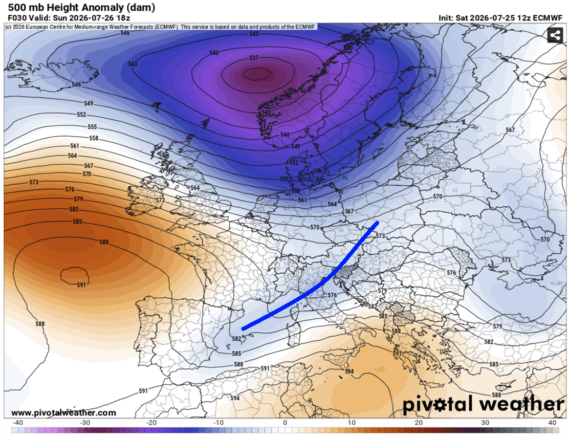
The current synoptic setup is characterized by a "blocked" pattern, a meteorological configuration that often leads to prolonged and intense weather events. A deep, persistent upper-level low is currently anchored over Northern Europe, effectively "locked" between two formidable high-pressure ridges—one situated over the North Atlantic and the other over Russia.
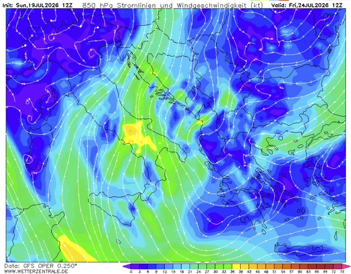
This structural rigidity in the atmosphere has forced a secondary shortwave trough to track eastward across Central Europe. As this wave interacts with the record-breaking heatwave currently gripping the Mediterranean, it triggers a rapid destabilization of the air mass. At the surface, a primary low-pressure system is positioned over Western Norway, while a secondary, intensifying low is forming in the Mediterranean. This secondary system is acting as the engine for the impending outbreak, drawing in extreme heat and humidity, and funneling it directly into the Apennine Mountains and the Adriatic corridor.
Chronological Evolution: From Ligurian Bay to the Balkans
The evolution of this weather event is expected to follow a rapid, high-impact timeline:
- Early Sunday Morning (06:00 – 10:00 UTC): The initial convective cells will spark in the Ligurian Bay. As these storms move toward the north-central Apennines, they will encounter extreme moisture convergence.
- Mid-Day Sunday (10:00 – 16:00 UTC): Storms will begin to organize into multicell clusters and potentially isolated, intense supercells. These structures are expected to exhibit "training" behavior, where multiple storms follow the same path, dumping massive quantities of rain in a concentrated area.
- Evening (16:00 – 22:00 UTC): The focus shifts toward the Adriatic Sea. The "nose" of a low-level jet will emerge, creating stationary convergence zones. This is the period of highest risk for the coastal regions of Istria (Croatia) and southwestern Slovenia, where flash flood potential is at its maximum.
- Overnight (22:00 – 06:00 UTC): The system is expected to track into the Western Balkans, maintaining its intensity before gradually weakening as the forcing mechanisms move eastward.
Data-Driven Risk Assessment
The intensity of this event is predicated on a convergence of high-energy atmospheric parameters. Forecasters have highlighted several key variables:
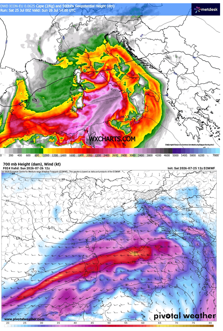
- Instability (CAPE): Mixed-layer Convective Available Potential Energy (MLCAPE) values are modeled to reach 2,000 to 3,000+ J/kg over the Tyrrhenian, Ligurian, and central Adriatic Seas. This represents extreme potential energy, providing the "fuel" for explosive vertical cloud development.
- Wind Shear: Intense mid-level jet streams are overspreading the region. This creates the necessary shear to organize storms into supercells, capable of sustaining their intensity for hours and producing tornadoes.
- Precipitable Water (PWAT): Values ranging from 45 to 60 mm are exceptionally high for the region. This confirms that the primary threat from the storms will be "torrential and excessive" rainfall, leading to high-confidence forecasts of flash flooding.
Regional Risk Breakdown
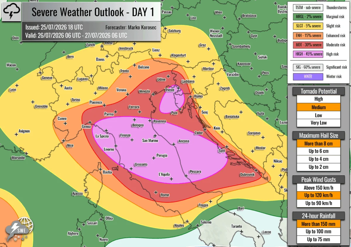
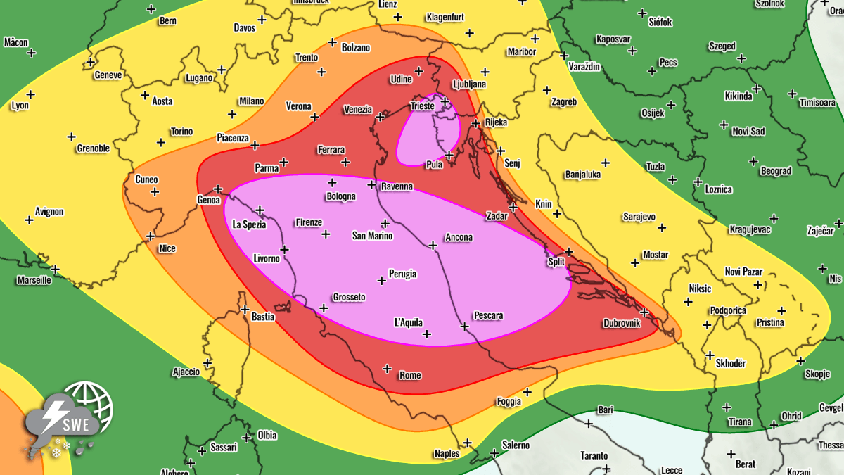
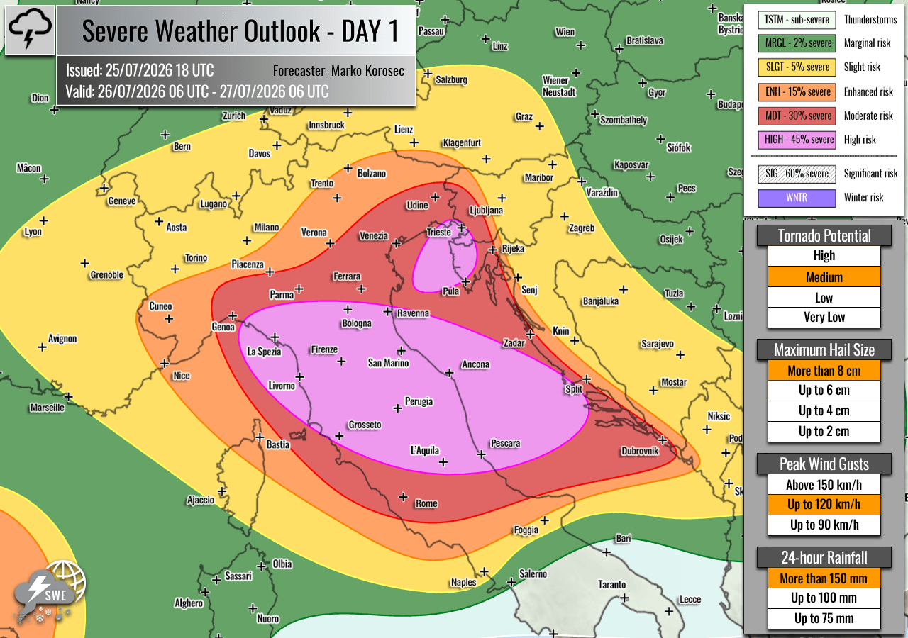
- High Risk (Purple Zones): Central/Northern Italy and the Central Adriatic. Residents should prepare for damaging wind gusts, giant hail (6–10+ cm), and tornadoes.
- High Risk (Coastal Istria & SW Slovenia): The primary concern here is the accumulation of rainfall. Models suggest 100–200 mm of rain within a 6–12 hour window, which would likely overwhelm local drainage systems and trigger dangerous flash floods.
- Enhanced/Slight Risk (Surrounding Areas): Southern Switzerland, Austria, and Western Croatia remain under a secondary threat tier. While storm coverage may be lower, the individual cells remain capable of producing localized severe weather.
Official Response and Preparedness
National meteorological services across the affected countries are currently updating civil protection warnings. The "High" risk designation, as issued by Severe Weather Europe, typically triggers a high-alert status for emergency services.
Key Implications for Public Safety:
- Tourism Impact: With the peak summer season in full swing, coastal areas in Italy and Croatia are densely populated. Local authorities are emphasizing the need for beachgoers and campers to monitor weather alerts via official channels.
- Aviation and Marine: The intense wind shear and convective activity will cause significant disruptions to regional air traffic and maritime navigation in the Adriatic.
- Infrastructure: Given the predicted hail size (10+ cm), significant damage to vehicles, rooftops, and solar installations is considered likely.
Broader European Context
While the Mediterranean is the primary focus, the "ripples" of this atmospheric disturbance extend further. An Enhanced (ENH) risk has been declared for the Western Mediterranean, specifically between Northeast Spain and the Balearic Islands, where severe wind and hail are expected.
Furthermore, a large Enhanced/Slight risk area covers Southwestern Russia. In this region, the combination of high shear and instability is expected to trigger discrete, highly organized supercells. These storms pose a distinct risk of tornadoes, as the low-level helicity in that region is particularly supportive of mesocyclone development. Simultaneously, a swath from the Netherlands through Northern Germany and into Poland remains under a Slight (SLGT) risk, with potential for gusty winds and marginal hail.
Conclusion: A Critical 24 Hours
The period between July 26th and 27th will be a test of resilience for the region. The combination of extreme summer heat and a powerful incoming cold front creates a "textbook" setup for a severe weather outbreak.
Citizens in the highlighted "High Risk" zones are urged to:
- Secure loose outdoor items that could become projectiles in high winds.
- Avoid low-lying areas or known flood plains.
- Monitor local radar and civil defense sirens closely throughout Sunday.
As the situation develops, real-time data from Meteoadriatic, Wxcharts, and PivotalWeather will remain vital in tracking the trajectory of these storms. The meteorological community remains on high alert, noting that with these levels of atmospheric energy, the margin for error is minimal.
Disclaimer: This report is based on meteorological data provided by Severe Weather Europe and reflects the forecast as of the time of publication. Weather is dynamic; please check local official forecasts for the most recent updates.