As the Northern Hemisphere transitions into the heart of the cold season, meteorologists have reached a rare consensus. Data from six major global seasonal climate models—including the ECMWF and UKMO—now points toward a definitive, high-impact winter for 2026/2027. The driving force behind this seasonal outlook is a formidable "Super El Niño" currently dominating the tropical Pacific, a phenomenon that is set to act as the primary architect of snowfall patterns from the American Southwest to the heart of Europe.
The central takeaway for the upcoming season is a distinct redistribution of moisture and cold. While the southern and central United States are bracing for an uptick in winter precipitation, the northern latitudes of North America and large swathes of Europe face a potential deficit. This is not merely a forecast of raw totals, but a shift in the atmospheric circulation that will likely dictate the travel, ski, and utility landscape for the next several months.
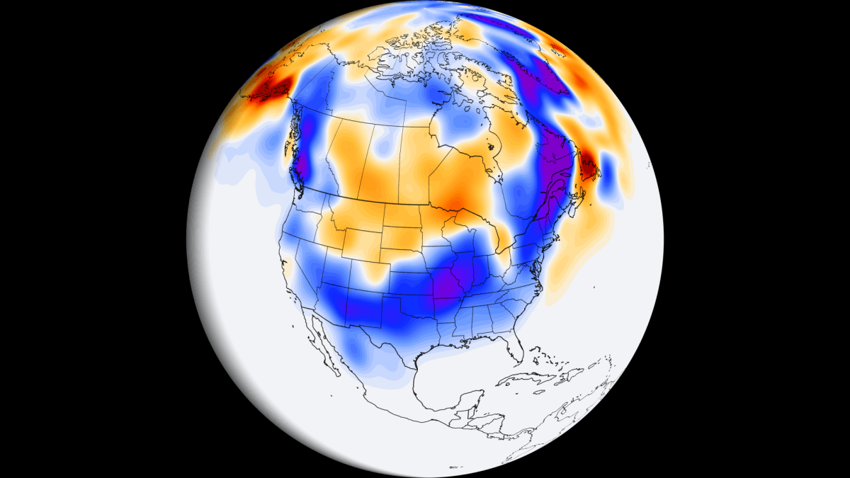
Main Facts: The "Super El Niño" Signature
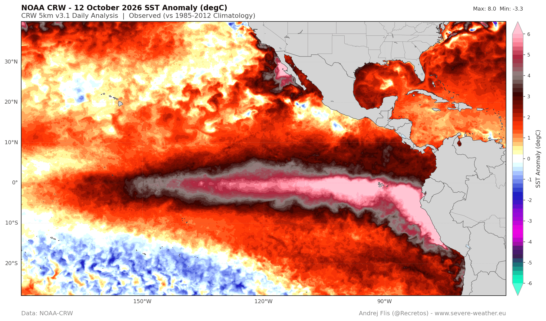
The current sea surface temperature anomalies in the tropical Pacific, as monitored by NOAA’s Coral Reef Watch (CRW) and other satellite platforms, have confirmed the presence of a Super El Niño. Ocean temperatures in the eastern Pacific have surged to more than 7°C (12.6°F) above the long-term average. In meteorology, an event of this magnitude is a "climate driver" that effectively overrides smaller-scale weather patterns, forcing the jet stream into a configuration that typically persists well into the spring of 2027.
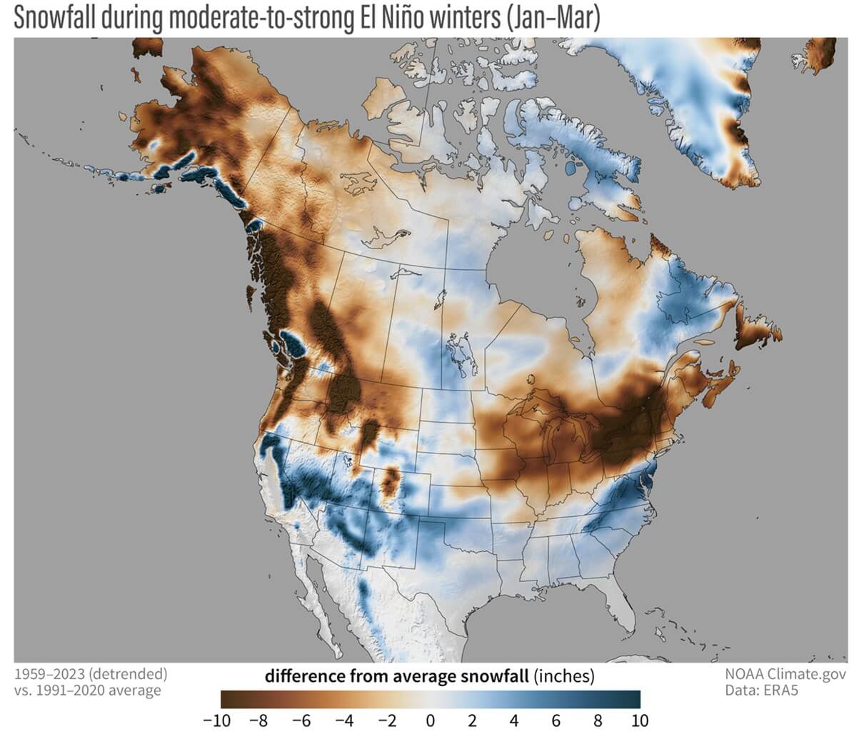
Under this influence, the Pacific jet stream is expected to extend and strengthen, pushing moisture-laden storms across the southern United States. For the central and southern U.S., this creates the perfect, albeit precarious, recipe for significant snowfall: a steady supply of moisture from the Pacific meeting intermittent cold-air intrusions. Conversely, this same jet stream configuration often acts as a barrier, preventing deep, frigid Arctic air from plunging into the northern United States and southern Canada, leading to a quieter, less snowy winter in those regions.
Chronology: A Slow Start to a Strong Finish
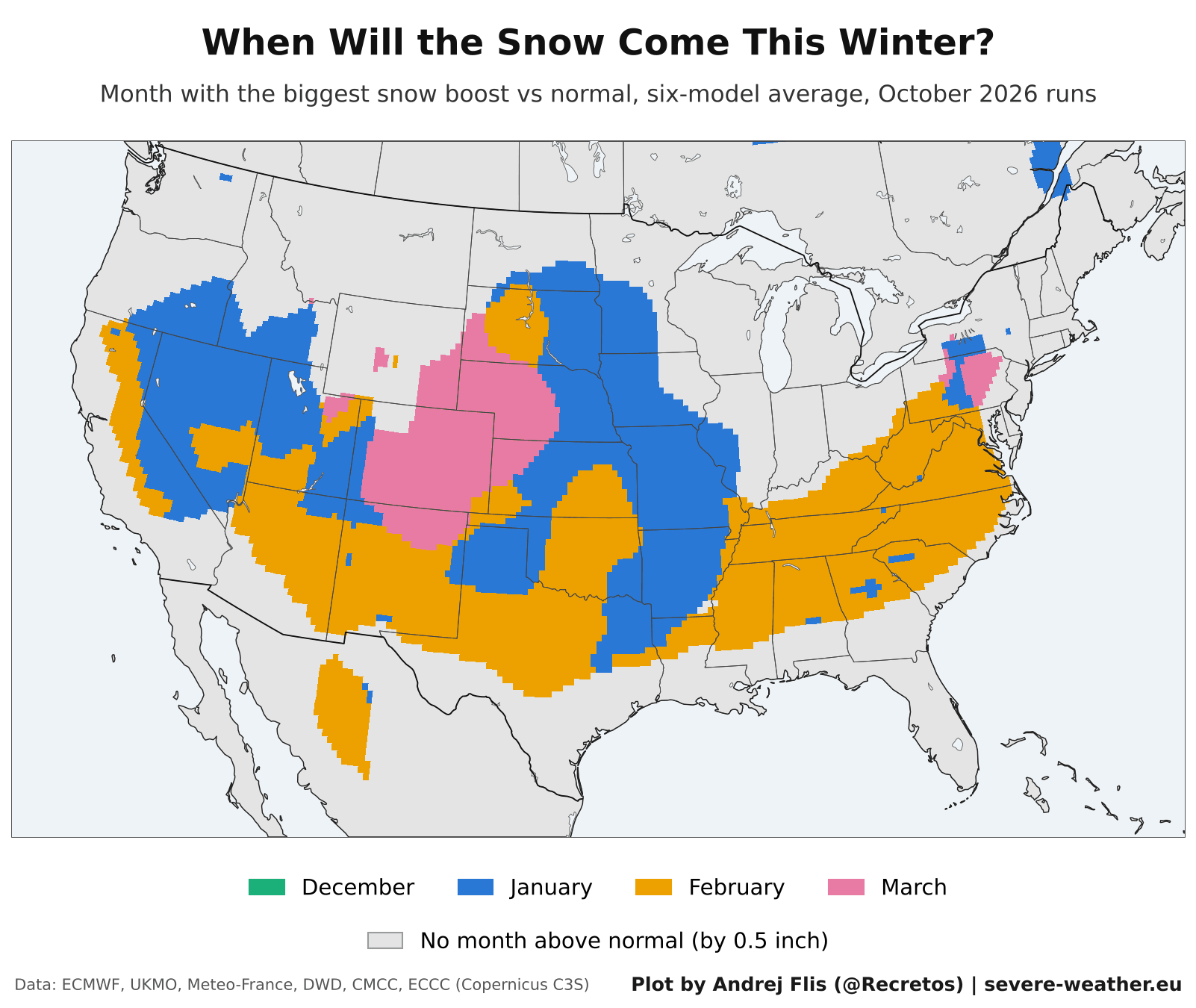
One of the most consistent findings across the six models is the expected timing of the snow season. December is currently modeled to be a "slow starter," with the influence of the El Niño pattern taking time to mature into its full-scale winter configuration.
The strongest snowfall signals—the periods where the models indicate the most significant departures from historical averages—are projected to arrive in the second half of winter. January and February are poised to be the most active months for the southern and central United States, with the potential for these patterns to extend into early spring. For regions like the Southern Rockies and the Southern Plains, this suggests that the most critical snow events may occur long after the holiday season has passed.
Supporting Data: Regional Breakdowns and Model Shifts
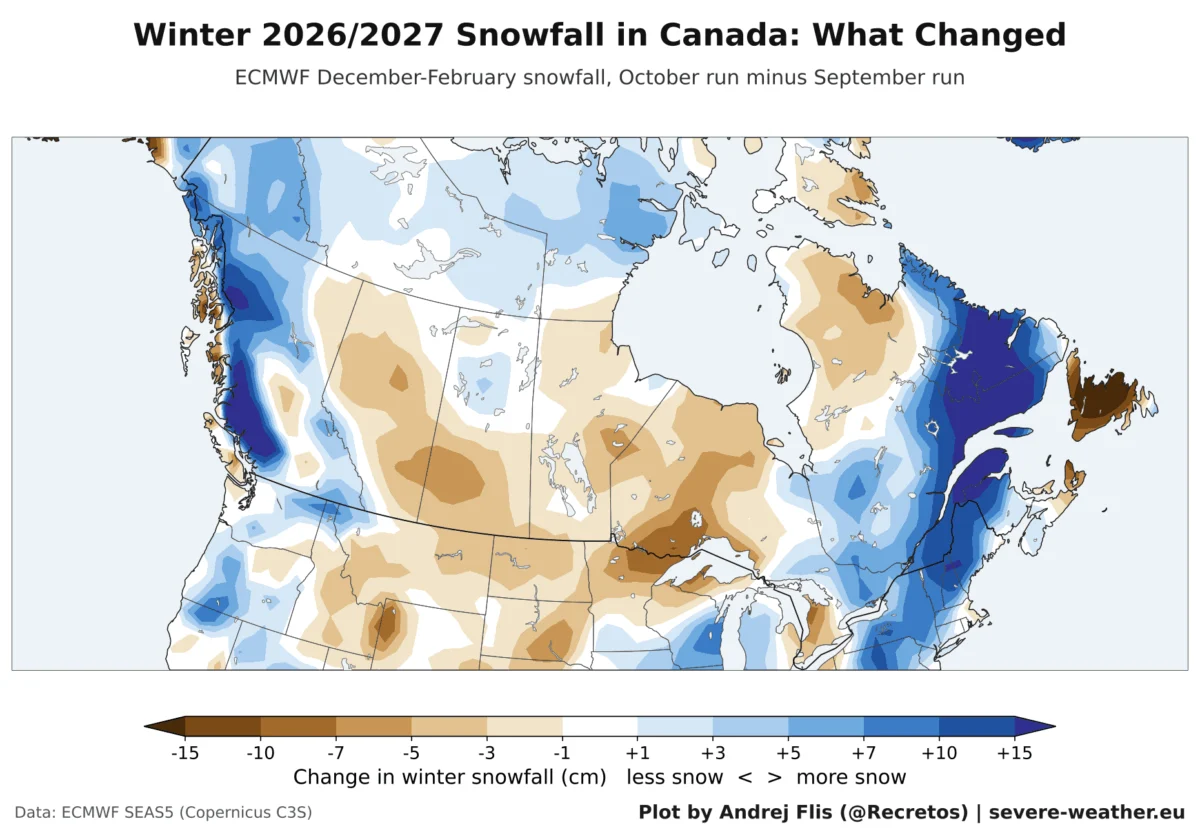
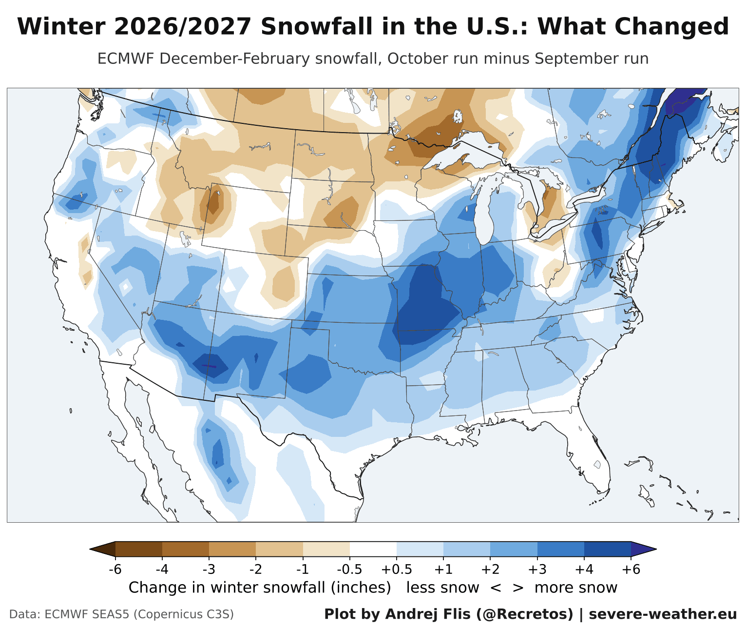
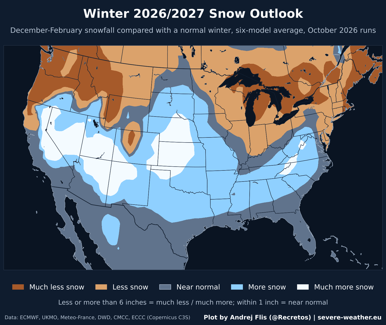
The October update to the ECMWF model provides a granular look at how expectations have evolved since September. In the United States, the trend toward increased snowfall in the south has solidified. The Ohio Valley, the Central Midwest, the Southern Plains, and the Southwest have all seen upward revisions in their snow outlooks compared to the previous month.
The U.S. Outlook
- The Southwest and Southern Rockies: These regions are the primary "winners" in this forecast. Areas from Nevada and Utah down through Arizona and New Mexico are tracking for above-normal snow.
- The Northeast: While the latest runs added roughly 2.9 inches of predicted snowfall to the Northeast—a notable shift from September—the region remains on a trajectory for below-normal totals overall.
- The Northern Plains and Rockies: These regions saw a reduction in projected snow in the latest data, reinforcing the forecast for a drier-than-average winter in the northern tier of the U.S.
The Canadian Perspective
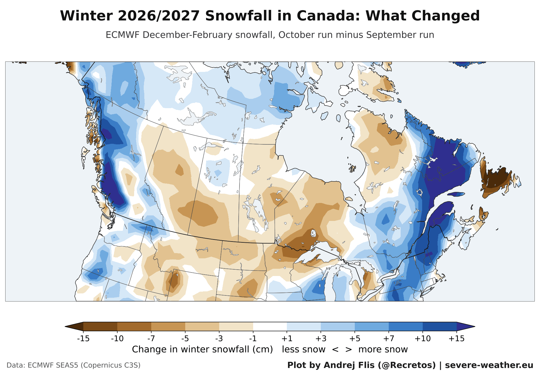
Canada faces a more challenging outlook. With the exception of localized gains in Quebec and Atlantic Canada, the majority of the nation is tracking below normal. The Prairie Provinces and Ontario are currently forecast to see less snow than typical for a winter season, a direct consequence of the persistent, warmer-than-average Pacific airflow that prevents traditional winter storm tracks from stabilizing over the northern plains.
The European Outlook
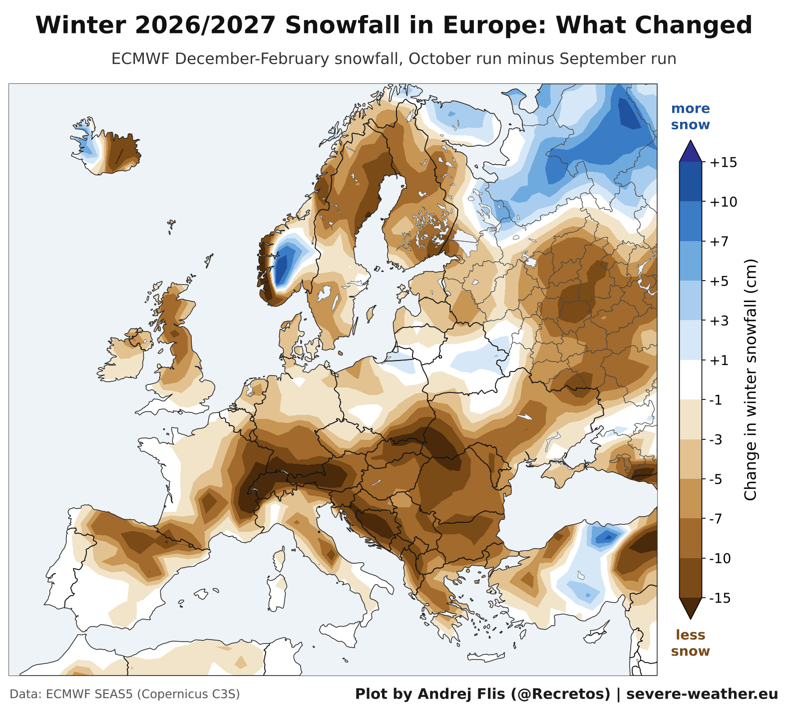
Europe is facing a broad-scale "weak" snow season. All seven major regions monitored by the seasonal models have seen their snowfall outlooks downgraded in the October update. From the UK and Ireland to the Balkans and the Alps, the models are in agreement: a lack of cold-air penetration from the north will likely result in below-normal snowfall across the continent. The only areas expected to see any reprieve are the far northeastern reaches of the continent, where colder air may occasionally bypass the dominant westerly flow.
Official Responses and Meteorological Context
While these seasonal outlooks are based on robust multi-model consensus, meteorologists are quick to add an important caveat: the "Polar Vortex." The stability of the stratospheric polar vortex remains the ultimate wildcard for winter 2026/2027.
Historical data shows that even in strong El Niño years, a sudden stratospheric warming event—which can cause the polar vortex to stretch or fracture—could result in a late-season "wildcard" event. A disruption of the vortex can force a sudden, dramatic release of Arctic air into regions that were previously forecast to have a mild, dry winter. While the current models do not factor in such a specific, high-impact event, researchers are tracking the vortex’s development with high priority.
Furthermore, it is important to note that these models function on a grid of approximately 100 km (60 miles). They are excellent for identifying broad, regional trends, but they cannot predict individual storm tracks or local topography-driven snow events. For a resident of a specific town, the trend matters significantly more than the raw, predicted inches of snow.
Implications for Skiing and Infrastructure
For the outdoor industry, this winter presents a tale of two extremes.
The Ski Industry Winners
The Southern U.S. ski resorts are gearing up for what could be an exceptional season. Mammoth Mountain in California leads the projections with over 30 inches of snow above the historical average. Similarly, Taos, New Mexico, and the San Juan Mountains in southern Colorado are looking at robust, powder-filled winters. These resorts are well-positioned to leverage the moisture-rich storm tracks coming off the Pacific.
The Challenges
Conversely, resorts in the Pacific Northwest and the Northern Rockies—such as Jackson Hole and Big Sky—are preparing for a challenging season with significant snowfall deficits. In Canada, the situation is even more uniform, with almost all major ski regions from British Columbia to Newfoundland trending below normal. In Europe, the Alps remain a point of high uncertainty; while models are leaning toward a below-normal season, the high-altitude nature of these ranges means that even a single significant storm event can drastically shift the seasonal total, leading to low confidence in the final outlook.
Infrastructure and Planning
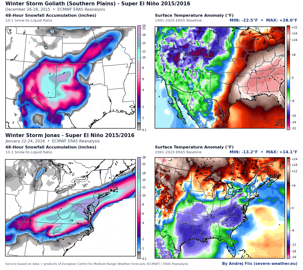
For municipalities and transit departments, the implications of this forecast are clear. Regions in the southern U.S. that are typically unprepared for high-volume snow should remain vigilant for the potential of "historic" events—similar to the 2015/2016 Super El Niño winter, which saw massive, infrastructure-crippling blizzards strike the Southern Plains. The increased likelihood of heavy, wet snow in the South, combined with a potential for late-season shifts, requires a high state of readiness for emergency management services.
Conclusion: Navigating the Winter Ahead
As we look toward the remainder of the 2026/2027 winter, the message from the scientific community is one of managed expectations. We are in the grip of a powerful climate driver that is fundamentally altering the distribution of winter precipitation across the Northern Hemisphere.
While the data provides a strong framework for understanding the coming months, winter weather is inherently chaotic. The Super El Niño sets the stage, but the daily, weekly, and monthly variations will be defined by the complex dance of the jet stream and the unpredictable behavior of the polar vortex. For those in the U.S. South and Southwest, the season looks bright and white; for those in the North and in Europe, the season may be defined more by its brevity and lack of accumulation.
As always, residents are encouraged to stay updated through regional forecasts as the season progresses, and to keep in mind that in a year dominated by a Super El Niño, the "normal" rules of winter weather rarely apply. Keep your gear ready, your local forecasts bookmarked, and be prepared for a winter that promises to be anything but ordinary.