As we look toward the winter season of 2026/2027, the global climate stage is being set by an atmospheric powerhouse. Meteorological data from across the globe confirms that a Super El Niño event is not merely developing—it is intensifying at a pace that suggests a historic, potentially record-breaking season. This massive shift in oceanic heat is already reshaping global circulation, promising a winter defined by a distinct "split-flow" pattern that will dictate temperature and snowfall anomalies from the bustling cities of North America to the diverse landscapes of Europe.

Main Facts: The Anatomy of a Super El Niño
At the heart of the 2026/2027 winter forecast is the tropical Pacific. El Niño, the warm phase of the El Niño-Southern Oscillation (ENSO), involves a shift in atmospheric pressure and ocean temperatures that triggers a domino effect across the Northern Hemisphere.
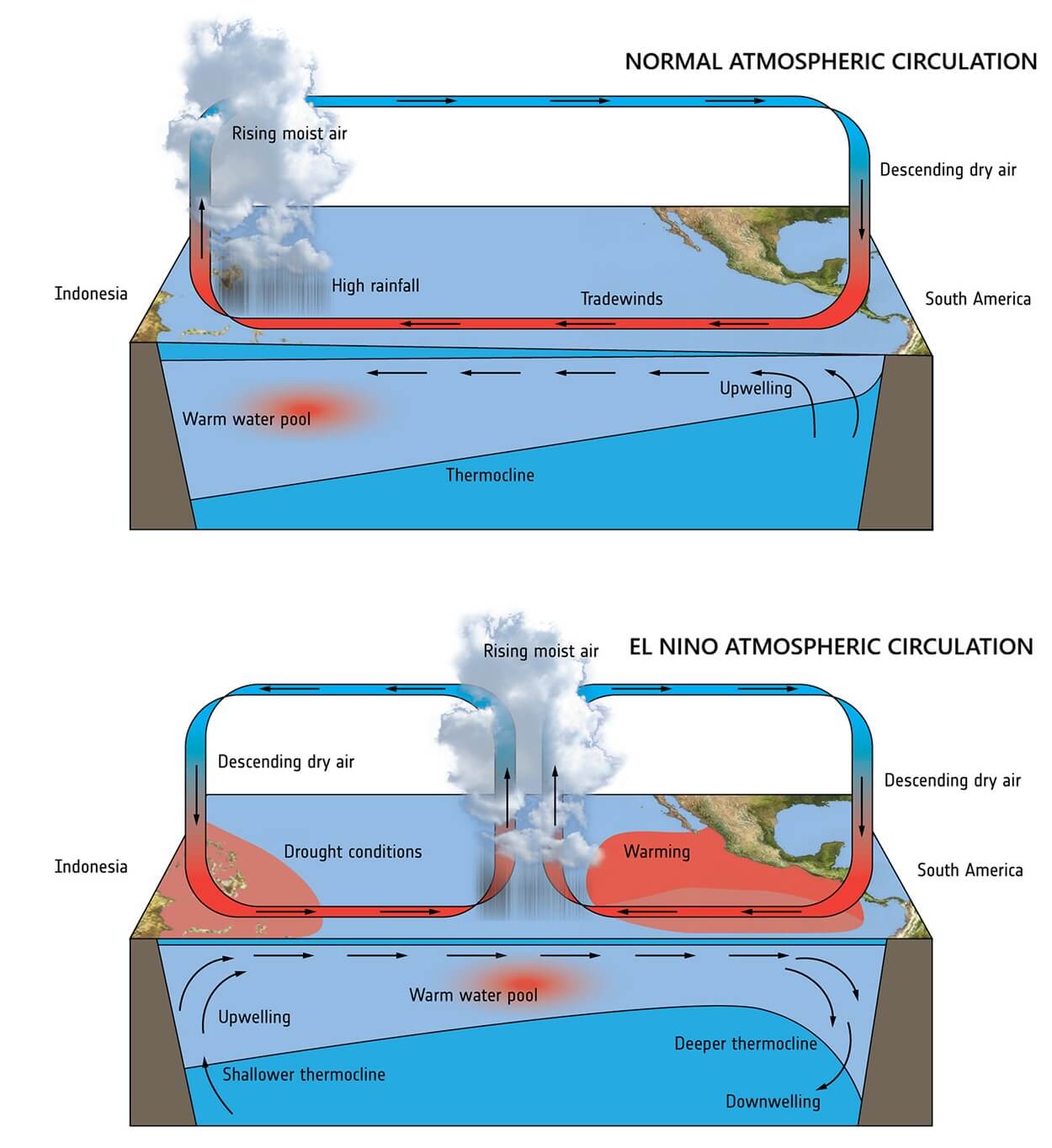
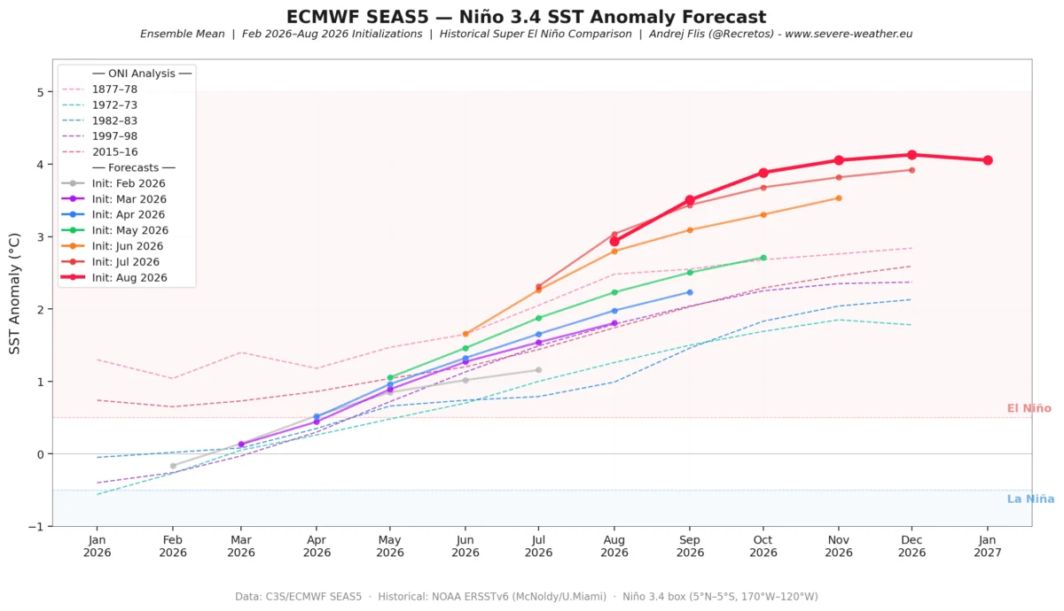
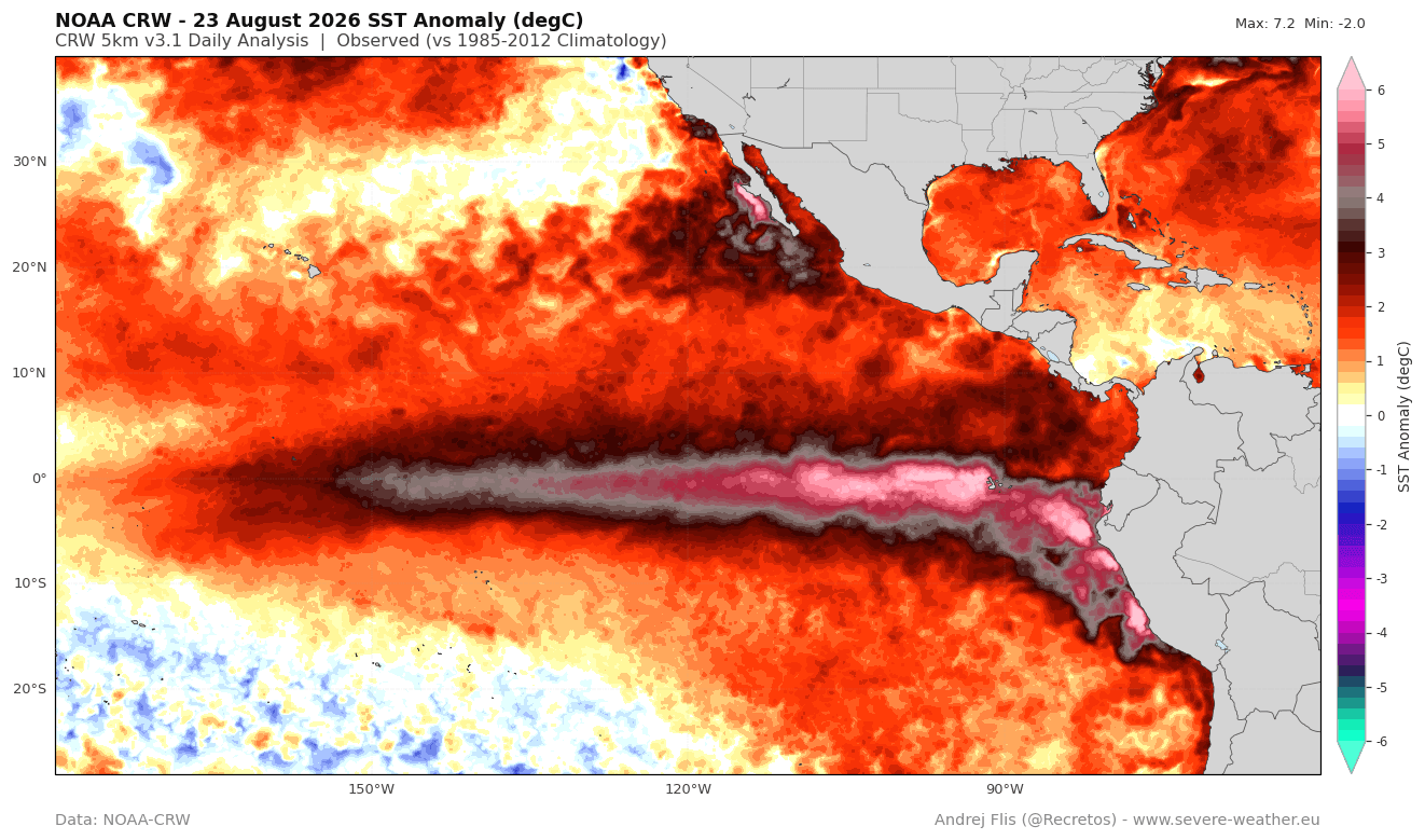
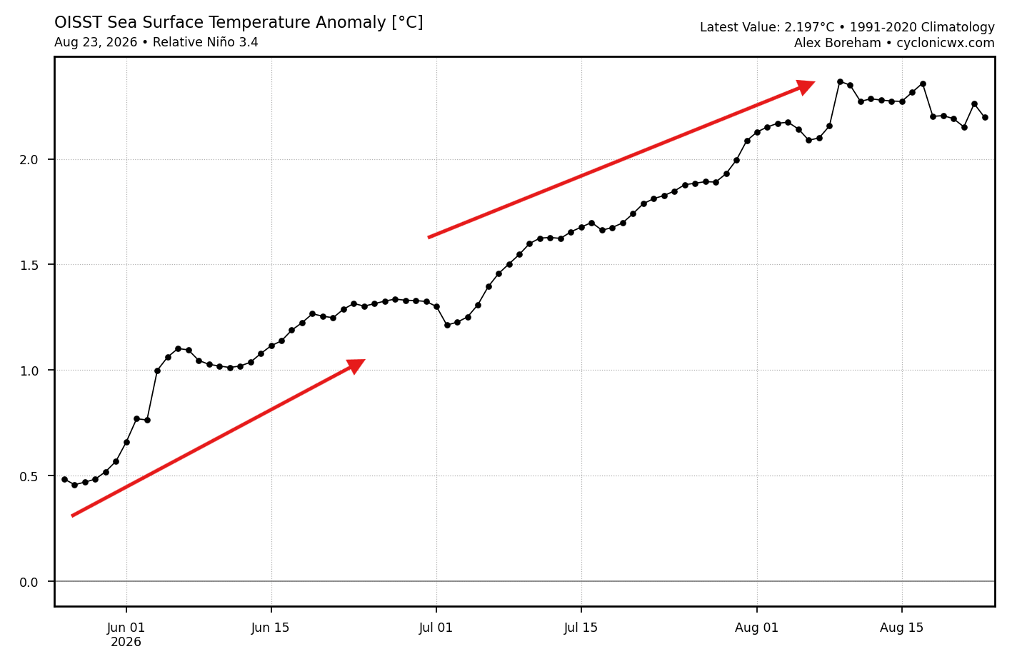
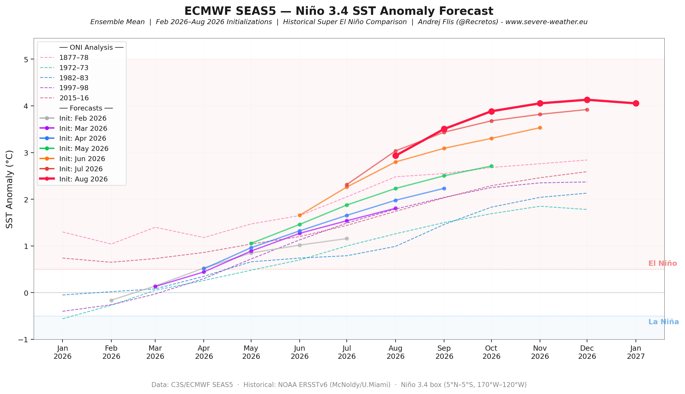
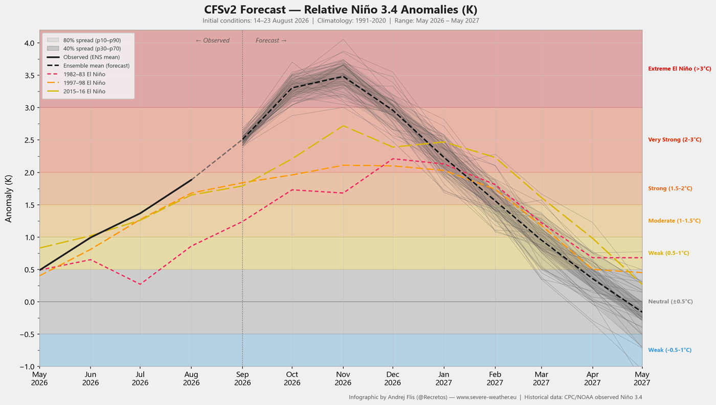
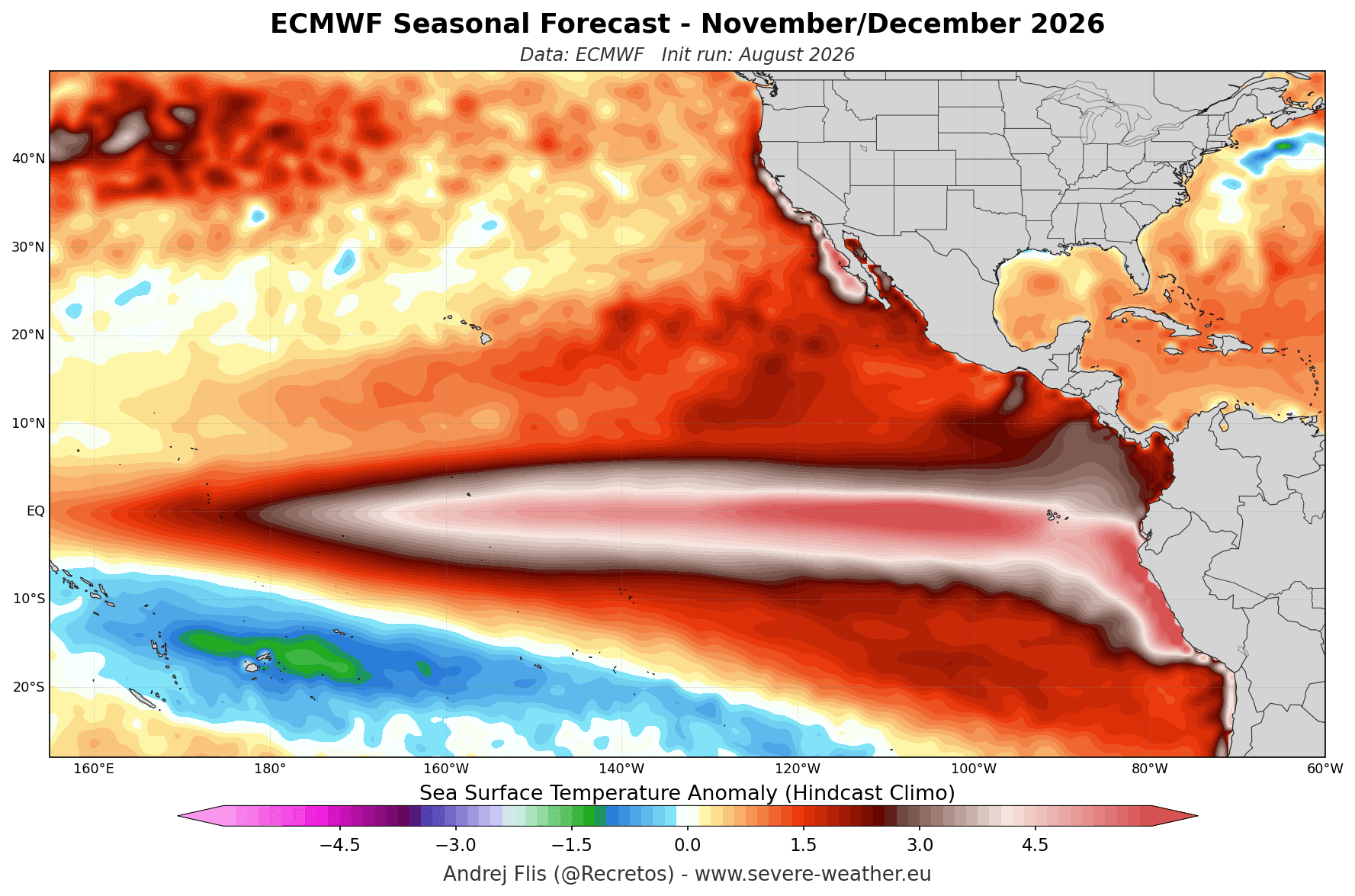
The current event is classified as a "Super" El Niño because seasonal sea surface temperature anomalies in the key monitoring regions have already breached the +2°C threshold, with localized spikes reaching upwards of 6°C above normal. This is supported by a massive subsurface "Kelvin Wave"—a deep, warm-core anomaly moving eastward beneath the surface of the Pacific. This Kelvin Wave acts as the engine of the event, providing a sustained, consistent supply of energy that will fuel the atmospheric response well into the winter months.
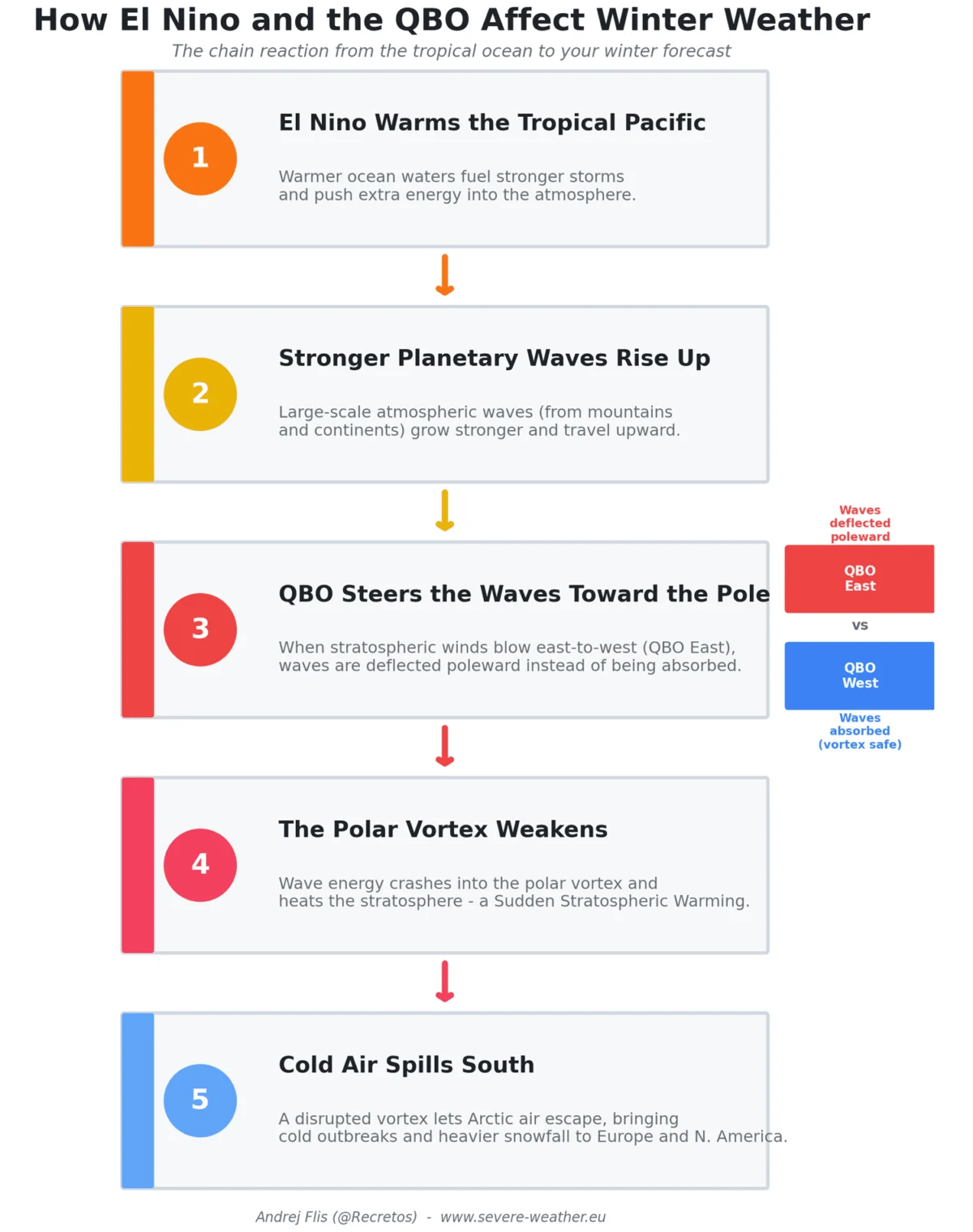
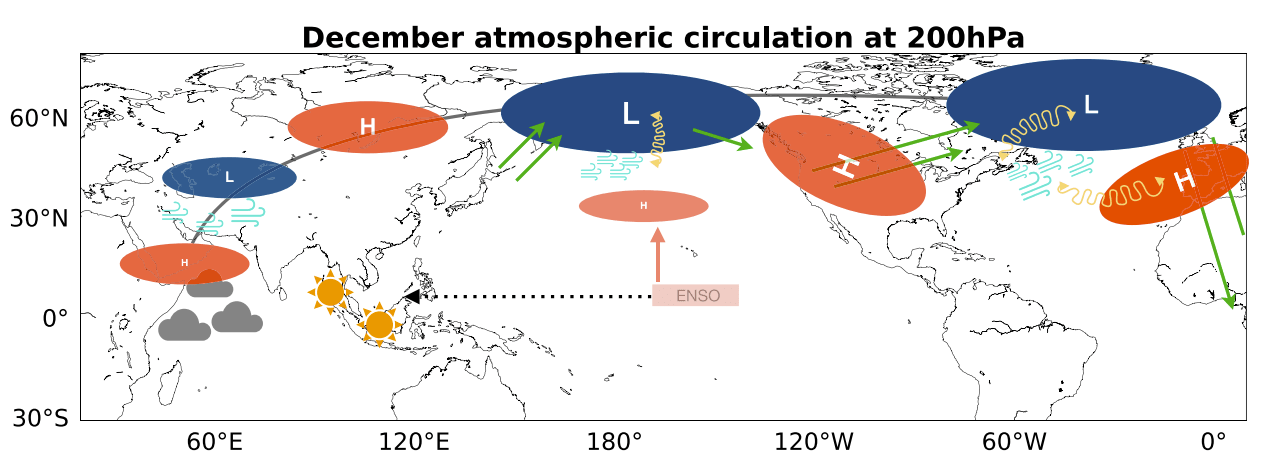
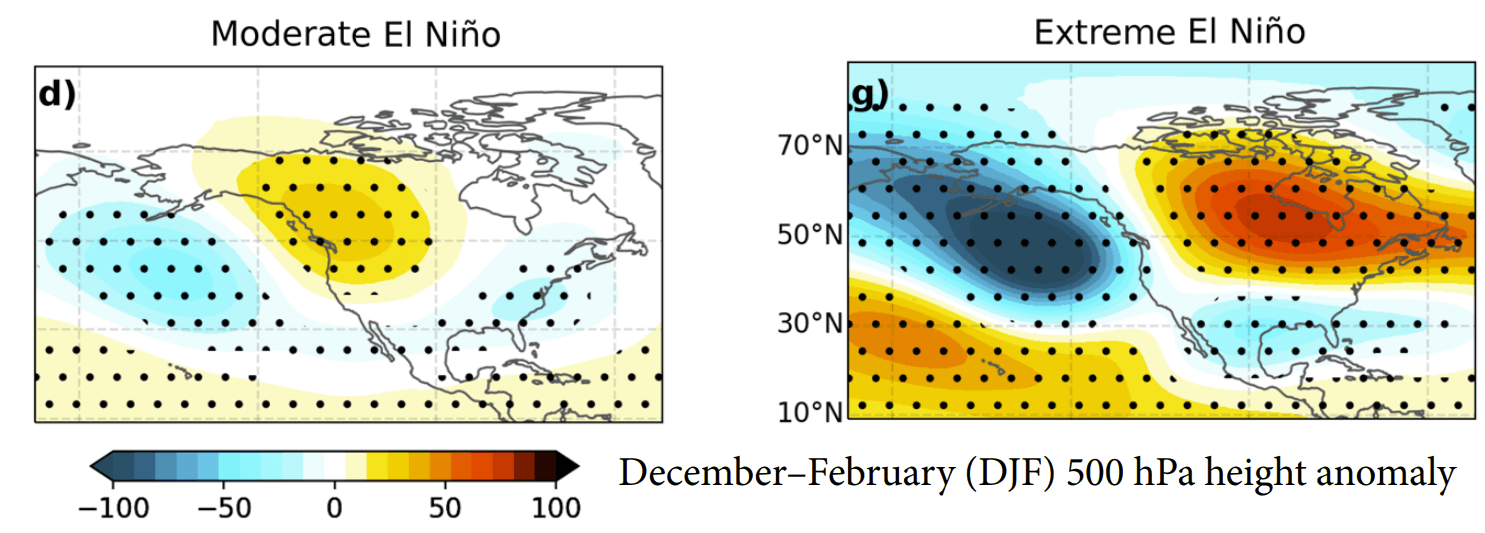
Unlike standard El Niño events, which may have moderate impacts, a Super El Niño creates a planetary-scale "wave train." This atmospheric highway shifts the jet stream, creating deep, persistent low-pressure zones over the North Pacific and forcing a corresponding high-pressure ridge over Canada and the northern United States.
Chronology of Development
The trajectory of this event has been clear since the summer of 2026. Ocean heat content has been steadily building, and as we move toward the peak of the winter season, the interaction between the ocean and the atmosphere has reached a critical threshold.
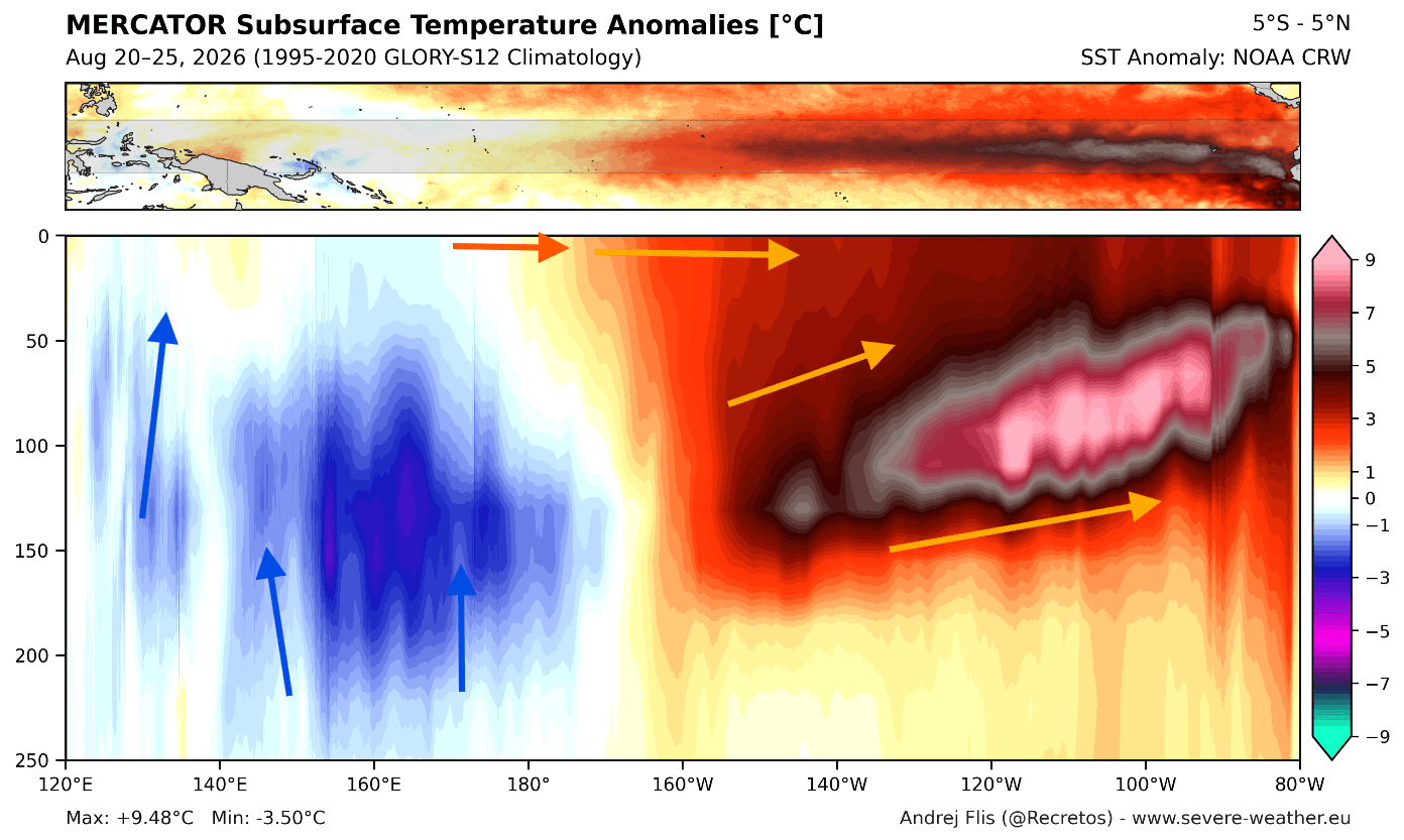
- Late Summer 2026: Subsurface anomalies peaked in intensity, confirming the formation of a powerful Kelvin Wave.
- Autumn 2026: Atmospheric circulation began to align with the oceanic anomalies. Forecast models, including the ECMWF (European Centre for Medium-Range Weather Forecasts), began consistently trending toward a record-strong peak.
- December 2026 – January 2027: The peak of the Super El Niño is projected to occur during these months. This period will see the atmospheric response reach its maximum intensity, with the "split-flow" pattern becoming most pronounced.
- February 2027: Forecasts indicate a further amplification of the pressure patterns, with the northern high-pressure ridge and southern storm track becoming locked in place, maintaining the established winter trends.
Supporting Data and Model Consensus
To ensure accuracy, meteorologists rely on a multi-model approach. Both the ECMWF and the NOAA NMME (North American Multi-Model Ensemble) are in rare, high-confidence agreement regarding the winter setup.
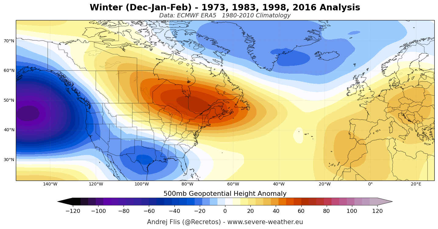
The ECMWF’s seasonal 500mb geopotential height forecasts reveal a deep, persistent low-pressure zone over the North Pacific. This is the "anchor" of the pattern, which effectively redirects the Pacific jet stream. Consequently, the jet stream is forced into a split: a weaker northern branch that permits milder air to settle over Canada and the northern U.S., and a dominant southern branch that acts as a highway for moisture-rich storms across the southern United States.
The NMME, which averages multiple independent model runs, confirms this temperature and precipitation split. The consensus points to a warm, dry winter for the northern tier of North America and a cooler, significantly wetter winter for the southern and eastern United States. For Europe, the models suggest a dominant westerly flow, which, while bringing abundant moisture, generally suppresses extreme cold across the continent.
The Polar Vortex: A Mid-Winter Variable
While the Super El Niño dictates the broad climate strokes, the stratospheric Polar Vortex remains the "wild card." The Polar Vortex acts as a spinning containment field for Arctic air. When it is strong, the cold remains locked at the poles; when it is disrupted, that cold air can spill southward.
Current projections from the UKMO (UK Met Office) and the ECMWF show a weakening signal for the stratospheric westerly winds between late December and January. This does not guarantee a Sudden Stratospheric Warming (SSW) event, but it indicates a state of instability. Should the vortex undergo a significant disruption, the resulting "Polar Express" effect could temporarily override the El Niño-driven warmth in the northern U.S. and Europe, leading to sudden, sharp cold-air outbreaks. However, historical data suggests that during Super El Niño winters, these disruptions often occur in the mid-to-late winter, potentially leading to a volatile end to the season.
Implications for North America
The winter of 2026/2027 will be a season of stark contrasts for North America.
United States and Canada
- The North: Expect a milder-than-average winter. Regions including the Northern Plains, the Great Lakes, and Southern Canada will likely experience fewer extreme cold snaps. Snowfall is projected to be below average in these areas, as the northern storm track remains subdued.
- The South and East: Residents in the Southern, Central, and Eastern U.S. should prepare for an active, wet, and often stormy season. The subtropical jet stream will drive a succession of low-pressure systems across these regions.
- Winter Sports: For skiers, the geographic divide is clear. The Sierra Nevada, the Southern Rockies, and the Four Corners region are expected to benefit from the southern storm track, likely seeing above-normal snowfall. Conversely, resorts in the Pacific Northwest and the Northern Rockies may face a challenging season with inconsistent snowpack due to the lack of cold air.
Implications for Europe
Europe’s winter will be heavily influenced by the North Atlantic circulation, which is being tuned by the far-reaching energy of the Pacific Super El Niño.
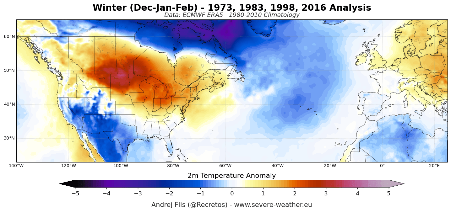
- Temperature: A dominant westerly flow from the Atlantic will likely keep much of the European continent warmer than average. This "maritime" influence acts as a buffer against deep, continental freezing temperatures.
- Precipitation: The moisture-laden air arriving from the Atlantic will likely result in higher-than-average precipitation across western, central, and southeastern Europe.
- Snowfall: For the average European town, the outlook is for a green winter with rain rather than snow. However, the high-elevation regions—particularly the Alps above 2,000 meters—may see significant snowfall as the moisture-rich air is forced upward, provided temperatures remain just low enough. The Pyrenees, Apennines, and Scottish Highlands may struggle with lower-elevation snow coverage.
Conclusion: A Season of Extremes
The winter of 2026/2027 is poised to be a landmark season in meteorological records. Driven by the sheer thermal mass of a Super El Niño, the global atmosphere is shifting into a configuration that prioritizes moisture transport in the south and warmth in the north. While the broad seasonal patterns are now well-defined by our most sophisticated forecast systems, the influence of the stratospheric Polar Vortex reminds us that winter always retains the capacity for surprise. As we move into the heart of the season, monitoring these atmospheric waves will be essential for navigating what promises to be one of the most significant weather events of the decade.