Issued by: Severe Weather Europe | Forecaster: Marko Korosec
Valid Period: September 9, 2026, 06 UTC – September 11, 2026, 06 UTC
A volatile and dangerous weather pattern is set to unfold across large swaths of Europe this week. Meteorologists are warning of a significant, two-day severe weather outbreak stretching from the Balearic Islands across the Mediterranean basin, reaching into Northern Italy, Slovenia, and Croatia. Driven by the collision of a deep upper-level trough and the remnants of an intense marine heatwave, this system is expected to deliver a potent mix of giant hail, damaging winds, tornadoes, and life-threatening flash floods.
1. Executive Summary: A Multi-Hazard Threat
The atmospheric setup for September 9th through 11th is characterized by extreme instability and powerful wind shear. A deep trough currently moving into Western Europe is interacting with a collapsing high-pressure ridge, creating a steep pressure and temperature gradient. This configuration has primed the Mediterranean environment, where record-breaking sea surface temperatures are fueling an unusually high moisture content in the lower atmosphere.
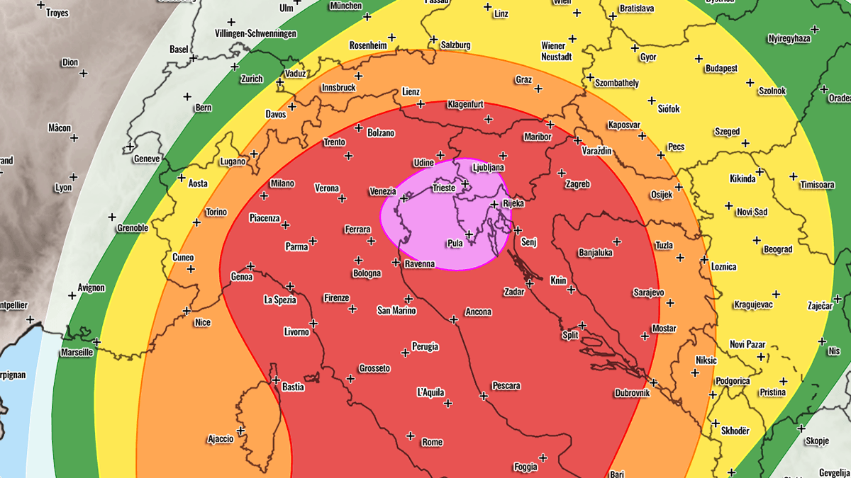
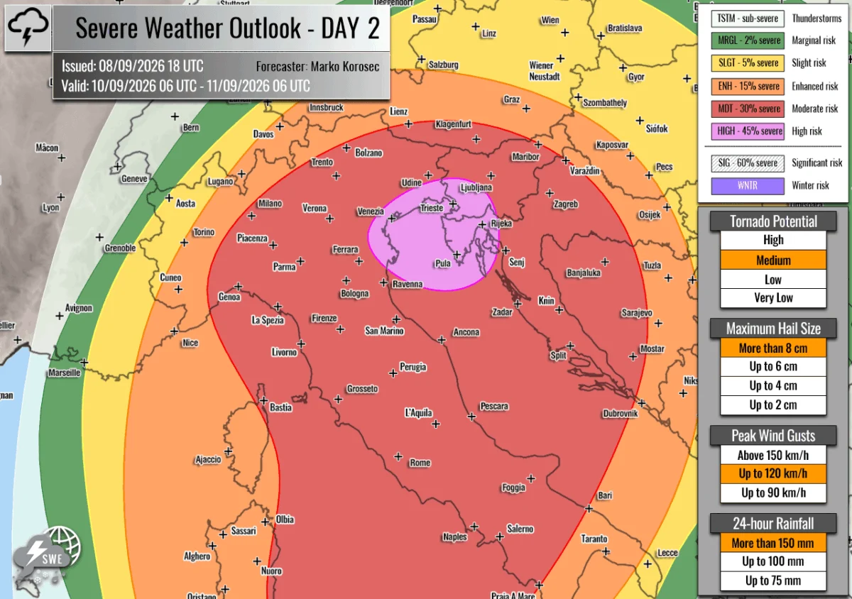
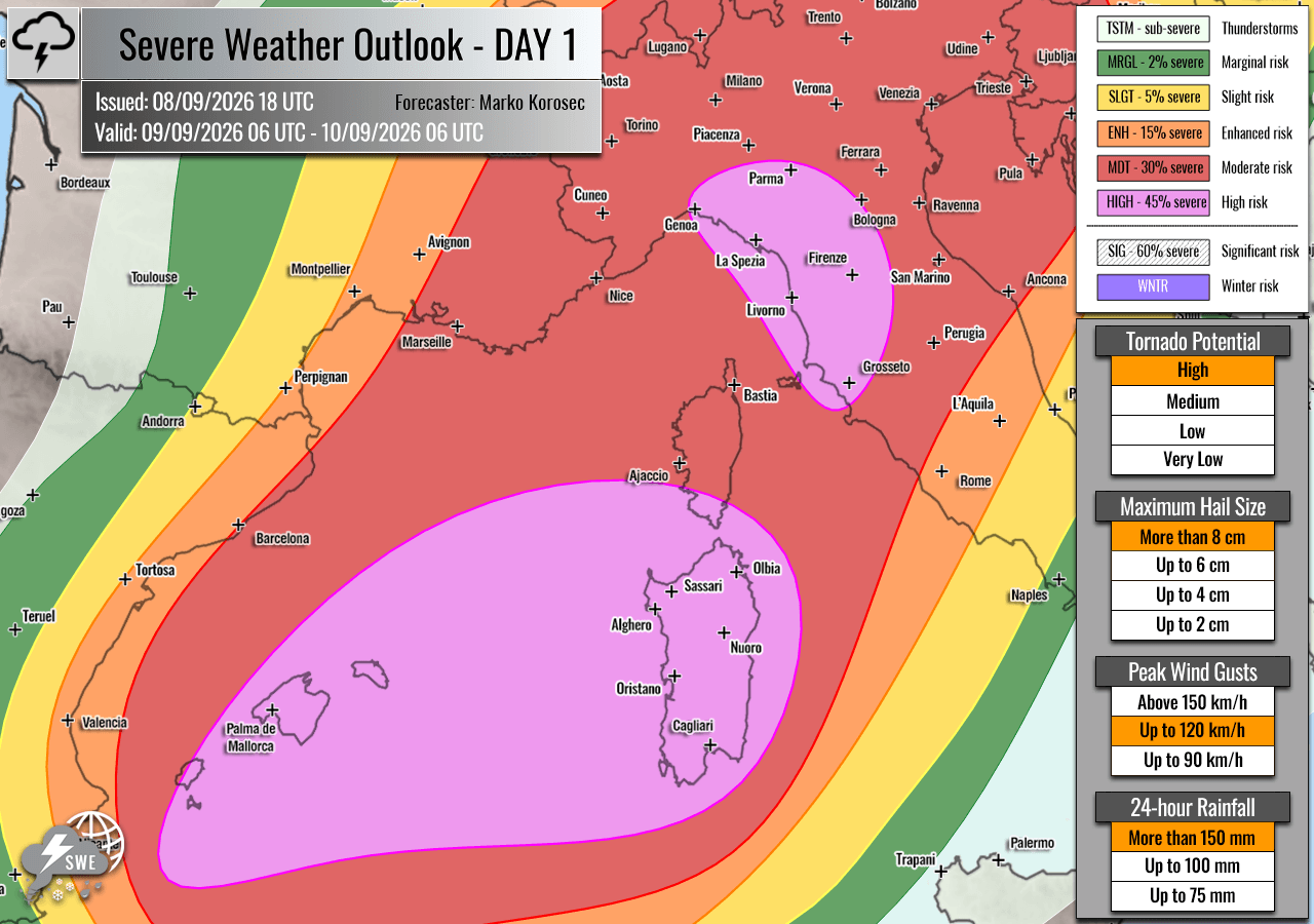
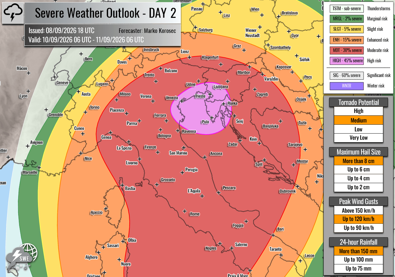
Forecasters have issued HIGH and MDT (Moderate) risk alerts across the Western and Northern Mediterranean. Residents in the Balearic Islands, Italy, Slovenia, and Croatia are advised to prepare for "explosive" convective development. The primary concerns include:
- Giant Hail: Stones ranging from 6 to 10 cm in diameter.
- Tornadoes: High potential for tornadic supercells, particularly in coastal regions.
- Flash Flooding: Rainfall totals exceeding 200–300 mm in localized areas, posing a severe threat to infrastructure and public safety.
- Destructive Winds: Severe convective gusts capable of causing widespread structural damage.
2. Chronology of the Event
Wednesday, September 9th: The Onset
The outbreak begins on Wednesday morning, with the Balearic Islands, southern Corsica, and Sardinia under the highest level of scrutiny. As the frontal system pushes east, the combination of mid-level jet stream winds and moisture-laden air will trigger rapid thunderstorm development.
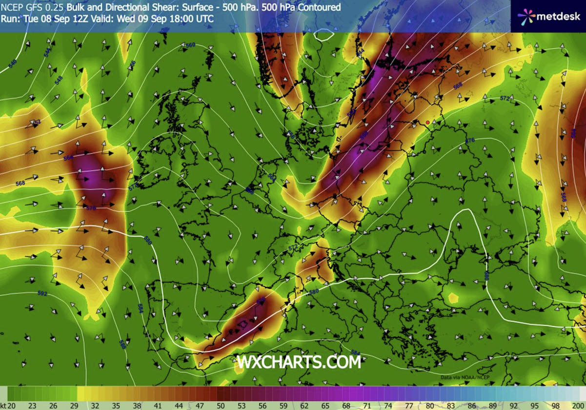
During the afternoon, the focus shifts to the Ligurian Bay and the northwestern Italian coast. The environment here is particularly concerning due to the "backing" of winds, which significantly increases low-level wind shear—a key ingredient for tornado formation. As the day progresses, these individual supercells are expected to merge into larger clusters, moving northeast across Northern Italy and eventually impacting Western Slovenia and Northwestern Croatia by nightfall.
Thursday, September 10th: Intensification and Peak
Thursday is shaping up to be the most critical window for the northern Adriatic and the Balkans. The persistent nature of the storms, combined with training cells (where storms repeatedly track over the same area), elevates the risk of extreme rainfall.
By mid-morning, the convective focus will be firmly locked on Northeastern Italy, the Northern Adriatic, and the Balkans. The primary mode of storms will evolve from discrete, intense supercells to large, organized convective systems. The threat of torrential rain is compounded by the region’s geography, as mountain ranges often exacerbate runoff, leading to rapid-onset flash flooding.
3. Supporting Meteorological Data and Analysis
Thermodynamic Instability
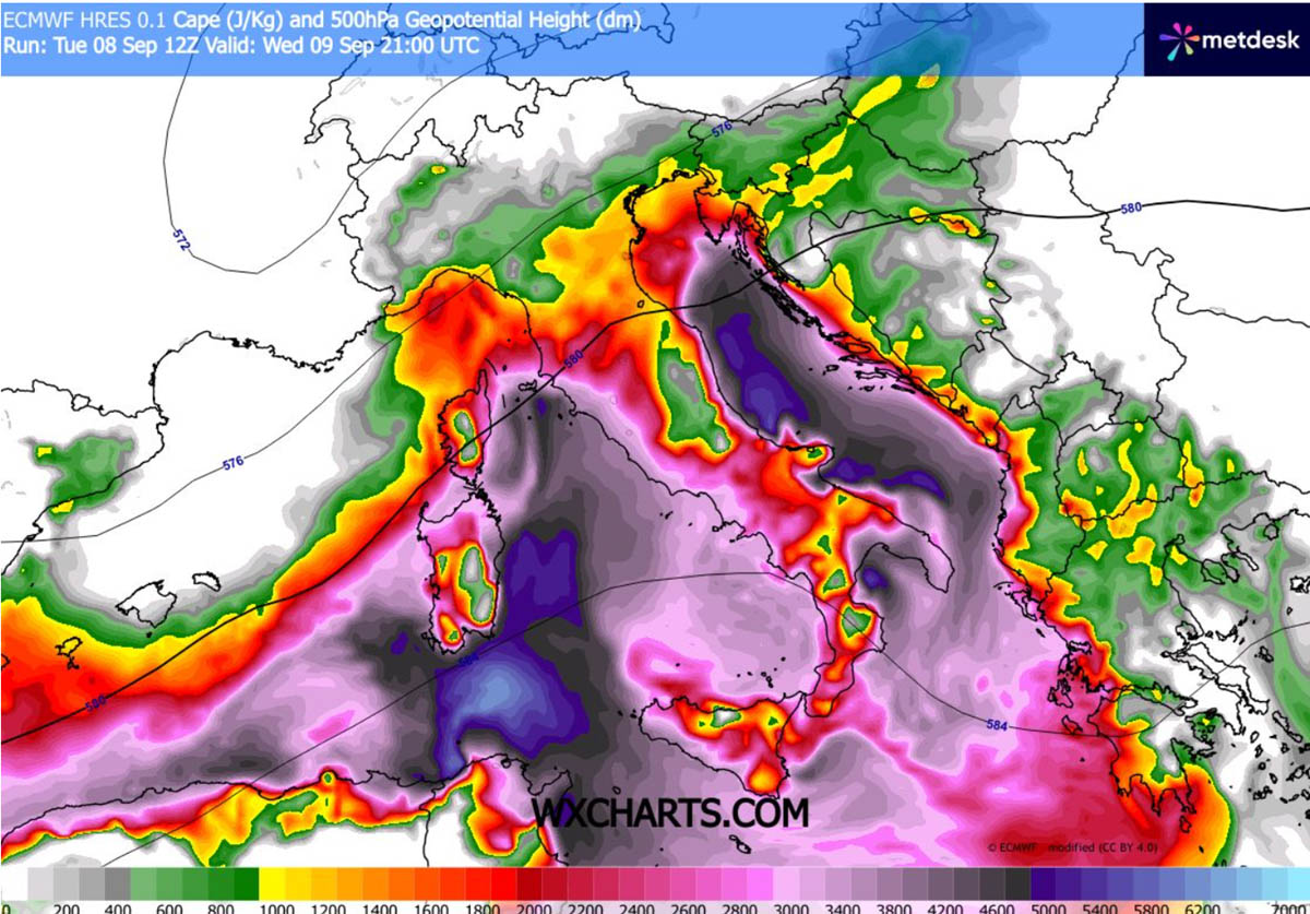
The "fuel" for this event is provided by the historic marine heatwave currently affecting the Mediterranean. High dewpoints—frequently reaching 25°C—are contributing to CAPE (Convective Available Potential Energy) values ranging from 3,000 to 4,000+ J/kg. In the world of meteorology, these are exceptionally high values, suggesting that the atmosphere is primed for vertical motion and explosive storm growth.
Wind Shear and Jet Dynamics
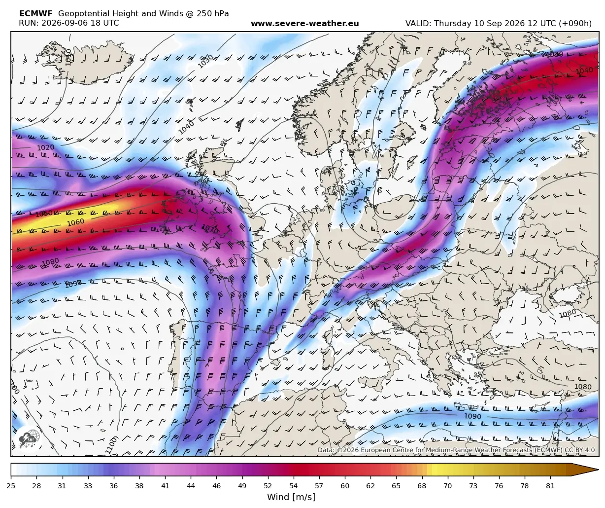
The synoptic overview reveals a strong southwesterly jet stream at the mid-levels. This provides the necessary "ventilation" for storms, allowing them to sustain their structure and intensity for longer periods. The "left exit region" of this jet, combined with a sharp cold front, provides the mechanical lifting mechanism required to initiate these severe cells. High-resolution weather models indicate that the interaction between the cold front and the humid, unstable Mediterranean air mass will be particularly violent along the western side of the Apennine Mountains.
Rainfall Projections
Hydrological models are predicting rainfall totals of 200–300 mm over a 36-hour period in the most affected sectors. For regions that have suffered through months of severe drought, this sudden deluge is a double-edged sword: while it may alleviate long-term water shortages, the ground’s inability to absorb such high volumes of water instantaneously significantly increases the risk of catastrophic landslides and urban flooding.
4. Official Responses and Public Safety
National meteorological services across the affected countries have begun issuing red and orange alerts. Emergency management agencies in Northern Italy and the Adriatic coastal regions are mobilizing resources to respond to potential power outages, structural collapses, and road closures.
Recommended Precautions for Residents:
- Stay Informed: Monitor local weather updates from national authorities.
- Secure Property: Ensure loose objects are secured against high winds.
- Avoid Flood Zones: Do not attempt to drive through flooded roadways; just a few inches of fast-moving water can displace vehicles.
- Shelter Protocols: In the event of a tornado warning, seek shelter in the lowest level of a sturdy building, away from windows.
5. Implications for the Region
Infrastructure and Agriculture
The agricultural sector, already strained by the preceding heatwave and drought, faces significant risk. Large hail is notoriously destructive to orchards, vineyards, and greenhouses. Furthermore, the combination of flash flooding and wind damage poses a long-term threat to critical transport infrastructure, including major highway networks and mountain passes in the Alps and the Apennines.
Climate Context
Meteorologists are noting that this event is a stark example of how warming sea surface temperatures can alter the intensity of autumn weather systems in Europe. The Mediterranean, often described as a "climate change hotspot," is seeing higher energy availability for storms than in historical averages. This event serves as a reminder of the increasing need for robust infrastructure capable of withstanding more frequent and more intense "extreme weather" episodes.
Future Outlook
As the system moves out of the region on Friday afternoon, a period of cooler, more stable air is expected to settle over the central Mediterranean. However, the legacy of this event—particularly in terms of water management and recovery efforts—will likely persist for weeks. Residents are urged to remain vigilant throughout the duration of the event, as the forecast indicates that the threat remains high until the final passage of the cold front on Friday.
Disclaimer: This report is based on meteorological data current as of the time of publication. Residents should rely on their local meteorological services for real-time warnings and evacuation orders.