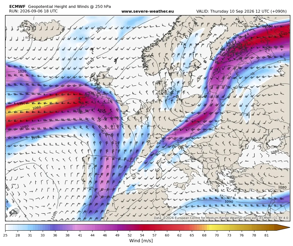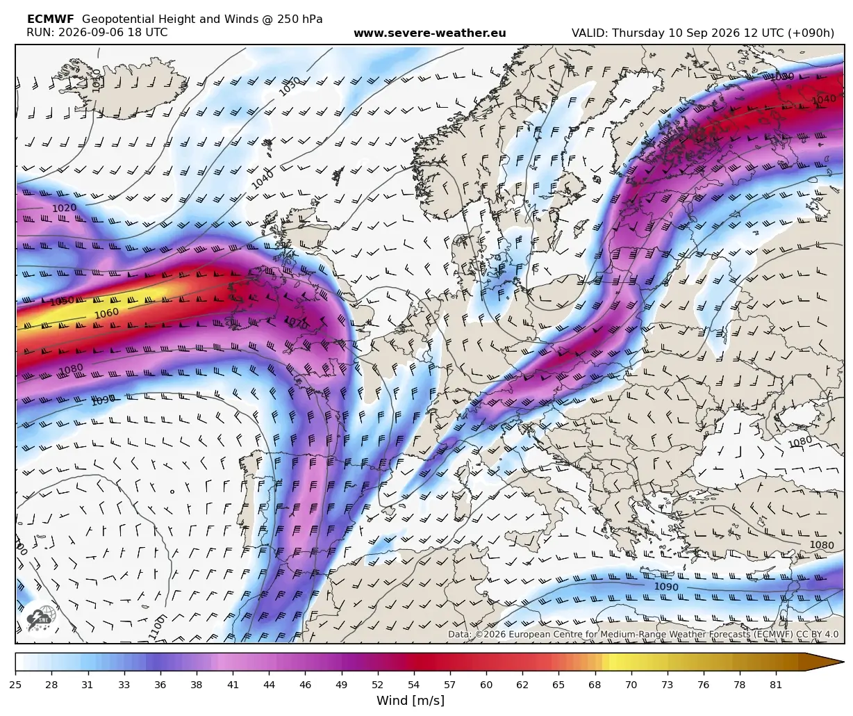
A seismic shift in the European meteorological landscape is currently underway. After a prolonged, record-breaking Heat Dome scorched the continent throughout early September 2026, a high-amplitude, "summer-killer" pattern is sweeping across the North Atlantic, signaling an abrupt and violent end to the unseasonable warmth.
Meteorologists are tracking a powerful upper-level trough—a massive, cold-core depression—that is currently crashing into the extreme, hyper-heated air mass that has been parked over the continent. This collision is not merely a cooling trend; it is the catalyst for a major, multi-day severe weather outbreak stretching from the crags of the Alps down to the Western Balkans. As the atmospheric transition unfolds, Europe is bracing for a dramatic thermal collapse, transitioning from summer-like extremes to a crisp, volatile autumn environment within a matter of hours.
The Synoptic Setup: The Collapse of the Heat Dome
The weather patterns observed over the first two weeks of September 2026 were characterized by a stable, persistent high-pressure ridge—a "Heat Dome"—that effectively locked in soaring temperatures and stifled atmospheric circulation. This stagnant air mass created a reservoir of heat that pushed daytime highs into the 35°C to 40°C range across much of Central Europe.

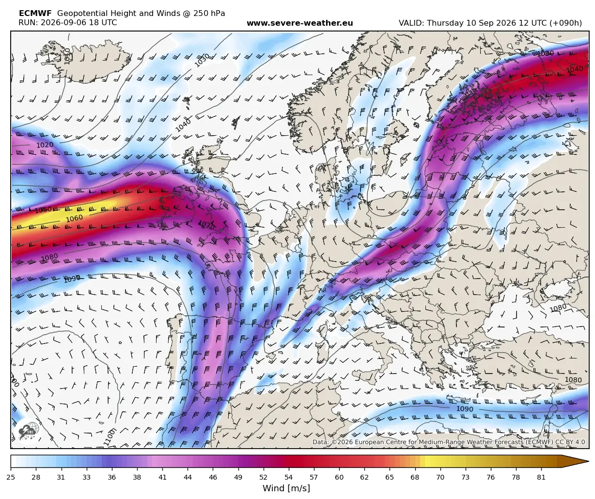
However, the synoptic situation changed as a deep, cold-core upper-level wave emerged from the North Atlantic on Tuesday. This wave, characterized by strong upper-level forcing, began dismantling the ridge. By mid-week, the system began to deepen, carving out a secondary trough that is effectively "cutting off" into the Northern Mediterranean.
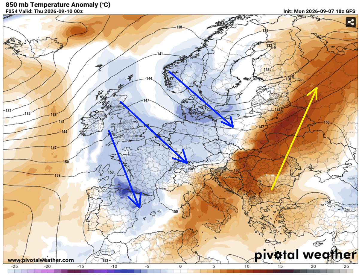
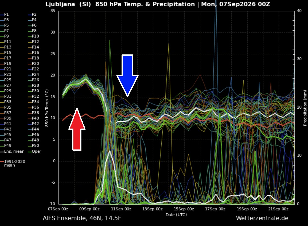
This configuration is textbook for extreme weather. As the cold air pushes east, it displaces the warm, buoyant air ahead of it. The hottest air mass, previously trapped under the heat dome, is being compressed and shoved toward Eastern Europe and western Russia. In its wake, a polar-origin air mass is surging into Central Europe, causing a "thermal collapse." Data suggests that temperatures at the 850 mbar level are expected to plummet by approximately 15°C within a 24-hour window, marking a definitive end to the summer season.
A Chronology of the Transition
The progression of this weather event follows a rapid, high-impact timeline that residents and authorities across Europe should monitor closely:
Tuesday: The Approach
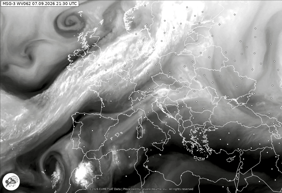
The frontal boundary was analyzed late Monday night as it made landfall in Western Europe, stretching from a deep low-pressure system over Scandinavia down toward the Azores. By Tuesday, the high-amplitude ridge began to buckle under the pressure of the advancing trough. The calm, sweltering conditions began to show signs of instability as humidity levels surged ahead of the front.
Wednesday: The Clash Begins
Wednesday marks the ignition point for the severe weather outbreak. As the cold front pushes into Eastern France, Switzerland, and the Balearic Islands, it encounters a "loaded gun" environment. Extremely high moisture content—fed by the ongoing Mediterranean marine heatwave—meets the advancing cold air. Throughout the day, the front is expected to sweep across Northern Italy and move into Austria and Slovenia, triggering violent thunderstorms.
Thursday: The Balkan Impact
By Thursday, the secondary low-pressure center will be fully established over the Northern Mediterranean, slowing the forward momentum of the front. This stationary behavior is concerning, as it allows for prolonged, high-intensity convective activity across the Western Balkans and the Adriatic coast. The instability will remain high, and the potential for severe weather will persist through the evening.
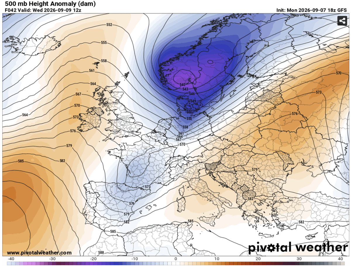
Friday into the Weekend: The Autumnal Turn
By Friday, the front will have pushed past the Balkans, allowing the polar-origin air mass to dominate. Residents will wake up to a significantly different atmosphere, characterized by lower humidity, gusty winds, and a crisp, autumn-like chill. High-altitude mountain passes in the Alps, which were bathed in sun only days prior, are expected to receive their first significant snowfall of the season.
Supporting Data: Instability and Atmospheric Energy
The severity of this outbreak is predicated on the interaction between extreme thermodynamic instability and dynamic forcing. Meteorologists look to "CAPE" (Convective Available Potential Energy) to measure the "fuel" available for storms.
In this event, CAPE values are projected to exceed 3,000–4,000 J/kg in the warm sector. This level of instability is exceptionally high for European latitudes in September. When combined with strong vertical wind shear—the change in wind speed and direction with height—the atmosphere becomes primed for the development of organized, severe storm structures.
The "Training Cell" Effect
One of the most critical concerns for the Northern Mediterranean, particularly the Ligurian and Adriatic coastlines, is the risk of "training" storms. This phenomenon occurs when individual thunderstorms form in a line and follow one another over the same geographical area, similar to cars on a track. Because the frontal system is moving slowly, these training cells could lead to extreme localized rainfall totals, with some models predicting 150–200 mm of rain within 48 hours. This volume of water falling on the drought-parched, heat-baked ground is a recipe for flash flooding and mudslides.
Implications for Public Safety and Infrastructure
The shift from extreme heat to violent storms presents a unique set of challenges for local governments and disaster management agencies.
- Flash Flooding: Urban areas in Northern Italy, Slovenia, and Croatia are at high risk. The rapid onset of heavy rain, combined with the "urban heat island" effect and potentially dry, hard-packed soil, will lead to immediate runoff.
- Structural Damage: The potential for "giant" hail—stones exceeding 5cm in diameter—poses a severe threat to vehicles, greenhouses, and roof structures. High-wind gusts from supercell storms could down power lines and topple trees, causing significant localized power outages.
- Transport Disruptions: The arrival of the first heavy snow in the Alps will likely impact high-altitude transit routes. Motorists in these regions are advised to be prepared for sudden winter-like driving conditions, even if they started their journey in warm weather.
- Agriculture: While the rainfall will provide some relief from the summer drought, the intensity of the accompanying storms could prove destructive to late-season harvests.
Official Responses and Meteorological Outlook
While national weather services across the affected countries are issuing varying levels of orange and red alerts, the consensus remains consistent: this is a major, life-threatening weather event.
Emergency management agencies in the Alps and the Western Balkans have advised the public to clear storm drains, secure loose outdoor objects, and avoid travel during the peak of the front’s passage. In Italy, the Civil Protection Department is closely monitoring the Ligurian coast, where the risk of localized landslides is highest.
As of now, climate models indicate that the pattern will remain "dynamic" well into mid-September. The collapse of the heat dome represents a fundamental shift in the regional climate regime, as the jet stream becomes more energized and active.
"We are essentially witnessing the ‘flushing out’ of a summer that refused to end," notes one lead meteorologist at a regional center. "The sheer speed of the cooling—a 20°C drop in under 24 hours—is a stark reminder of how rapidly atmospheric energy can redistribute itself."
The public is encouraged to stay tuned to local meteorological offices and official emergency channels as the front progresses. With the combination of severe winds, flash flood threats, and the potential for tornadoes, the next 48 to 72 hours will be a critical period for European weather safety.
Images and data for this report were provided by PivotalWeather and WXcharts.