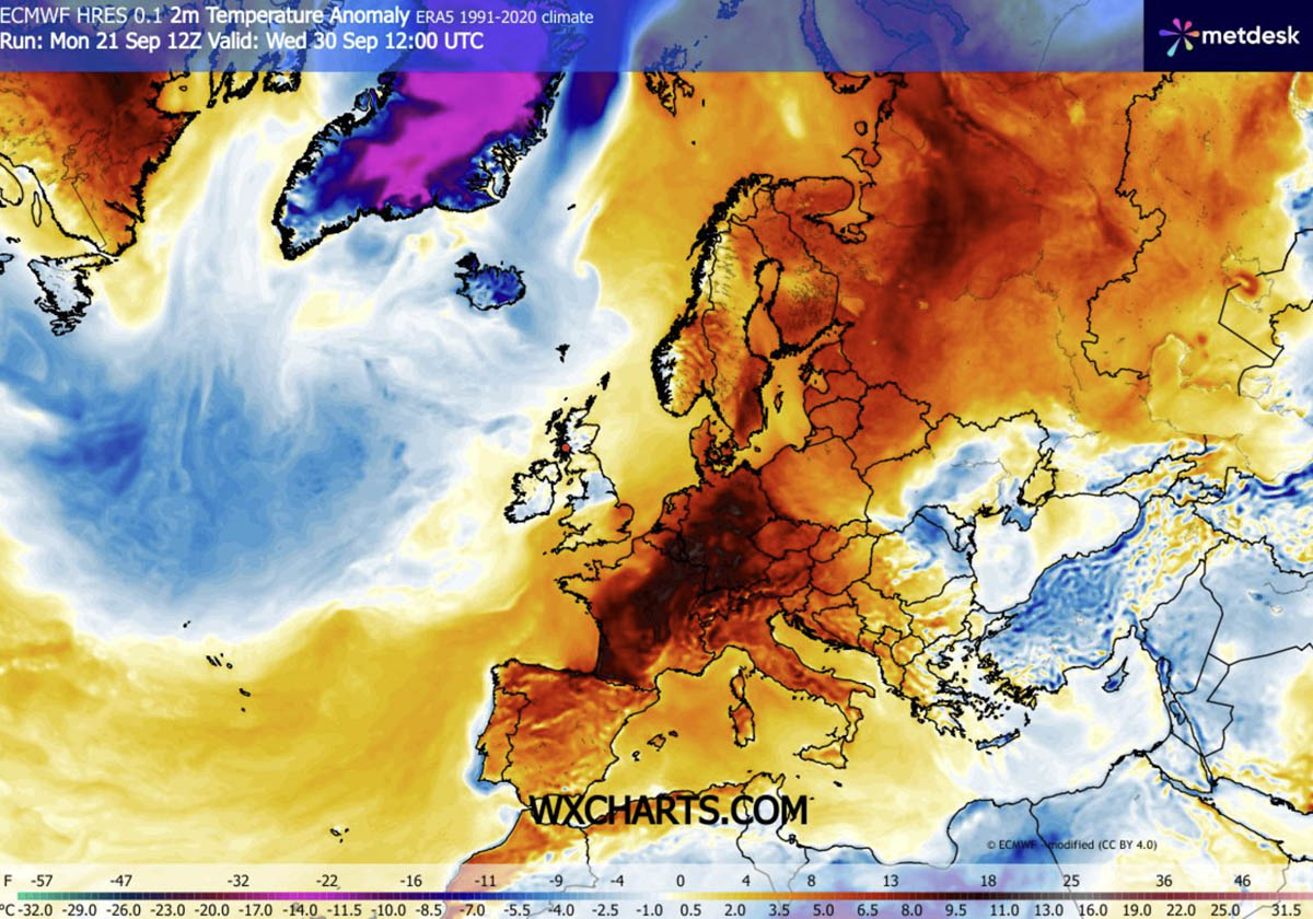
As September draws to a close, a significant and potentially record-breaking meteorological phenomenon is set to unfold across Europe. A massive "Heat Dome"—a high-pressure system characterized by its ability to trap heat like the lid on a boiling pot—is making a dramatic return to the continent. This atmospheric event is forecast to push temperatures well into the mid-to-high 30s (°C) in parts of Southwestern Europe, with unseasonably warm air extending its reach as far north as Scandinavia through the first week of October.
Main Facts: A Rare Late-Season Thermal Surge
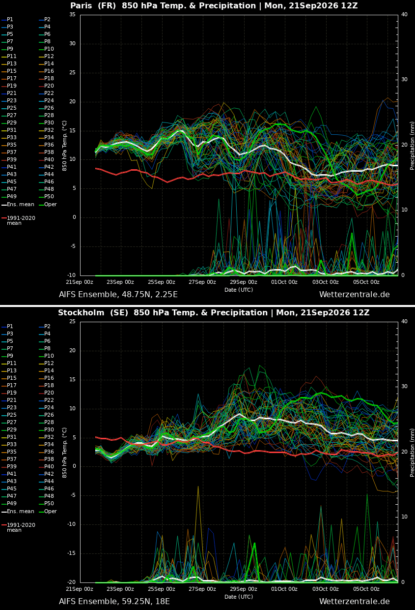
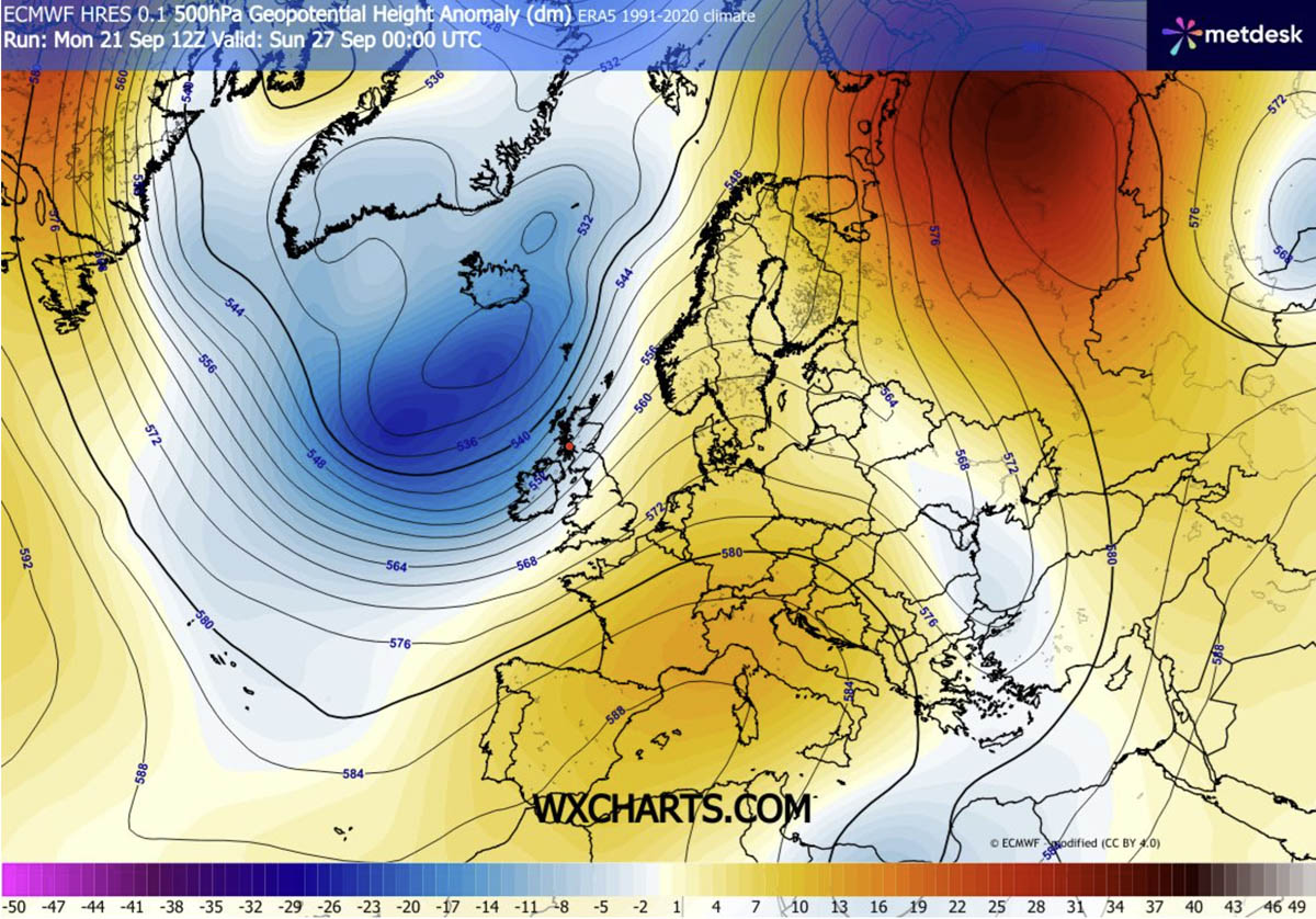
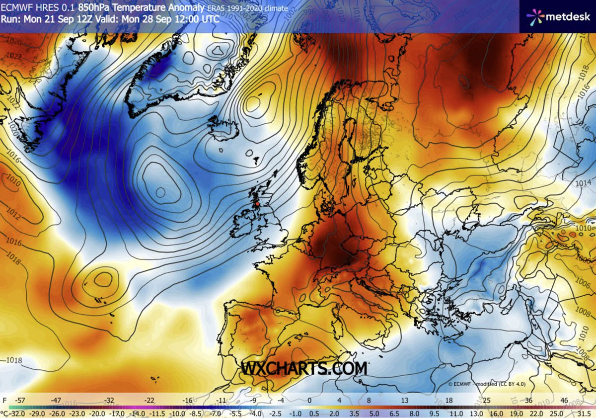
The current weather pattern is driven by a powerful upper-level ridge building north from the Mediterranean and North Africa. This ridge is effectively acting as a thermal pump, driving a plume of tropical air deep into the heart of continental Europe. Meteorological data indicates that 850 hPa temperature anomalies will climb between 8°C and 12°C above long-term seasonal averages.
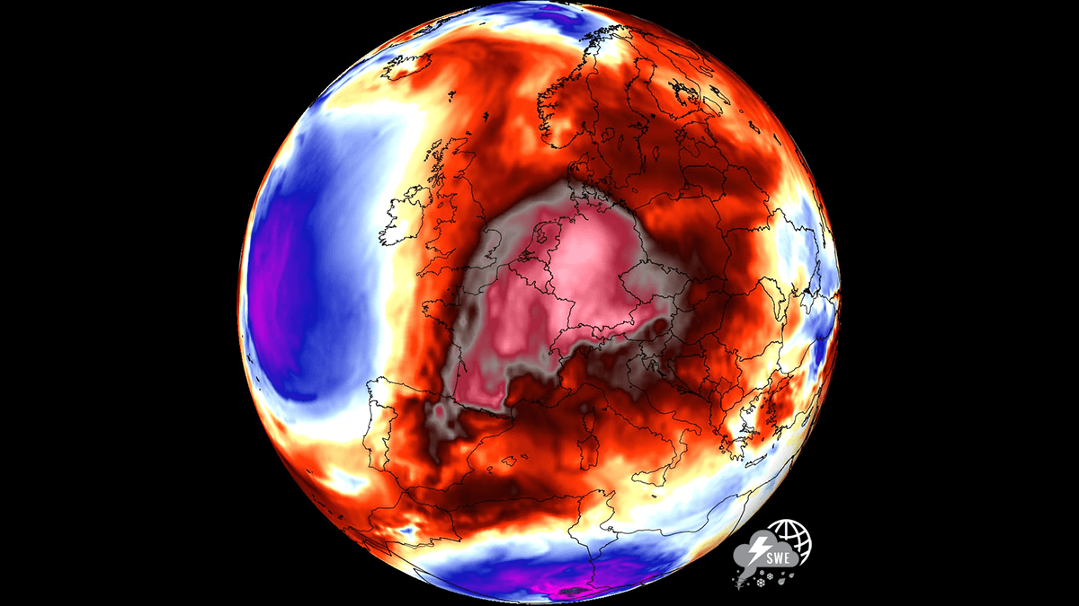
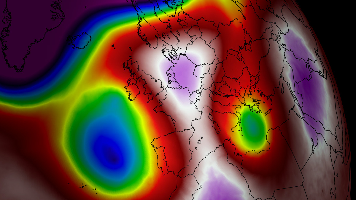
For many regions, this represents a significant deviation from the norm for late September and early October. While autumn typically signals the onset of cooling, the current synoptic setup suggests that urban centers from the Iberian Peninsula to Central Europe will experience summer-like conditions for the foreseeable future. The system is maintained by a classic atmospheric dipole: a deep, high-amplitude upper-level trough established over the North Atlantic, which serves to force the intense southerly jet stream to pump warm air northward.
Atmospheric Dynamics: The "Lid" Effect
To understand the severity of the coming week, one must look at the mechanics of the "Heat Dome." This phenomenon is not merely a warm front; it is a persistent, stationary high-pressure block that effectively "parks" itself over a large geographic area.
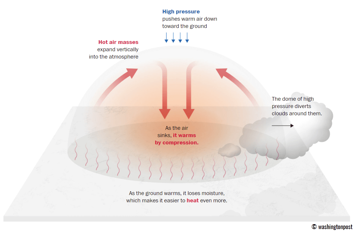
When this high-pressure system dominates, it creates a process known as atmospheric subsidence. Air at higher altitudes is forced downward toward the surface, causing it to compress and heat up rapidly. As this air descends, it suppresses cloud formation, ensuring maximum solar radiation reaches the surface. Because the system is slow-moving, it prevents cooler, maritime air from the Atlantic from encroaching upon the continent, essentially locking the heat in place. This "lid" effect is what leads to the sustained, dangerous temperature anomalies that can persist for days or even weeks.
Chronology of the Heatwave
The progression of this heatwave is categorized by a steady eastward and northward migration:
- Late September (Current): The heat dome is firmly established over the Iberian Peninsula. Spain and Portugal are bearing the brunt of the heat, with temperatures expected to climb toward the 40°C mark in some interior regions.
- The Weekend Transition: The ridge will begin to expand its influence across France and the Benelux region. By Saturday, Southern and Central France will see temperatures peaking in the mid-30s, while the UK will experience a brief but notable warm spell, with temperatures pushing into the mid-20s in the south-central regions.
- Early October: The anomaly shifts toward Germany, Poland, and eventually the Baltic region. By the first few days of October, the warmth will be felt as far north as Scandinavia, with Finland and Sweden experiencing temperature anomalies that are starkly higher than historical norms.
Supporting Data: Regional Breakdown
The intensity of this heatwave varies by region, but the broad scope of the phenomenon is clear across all forecast models (GFS and ECMWF).
Southwestern Europe: The Epicenter
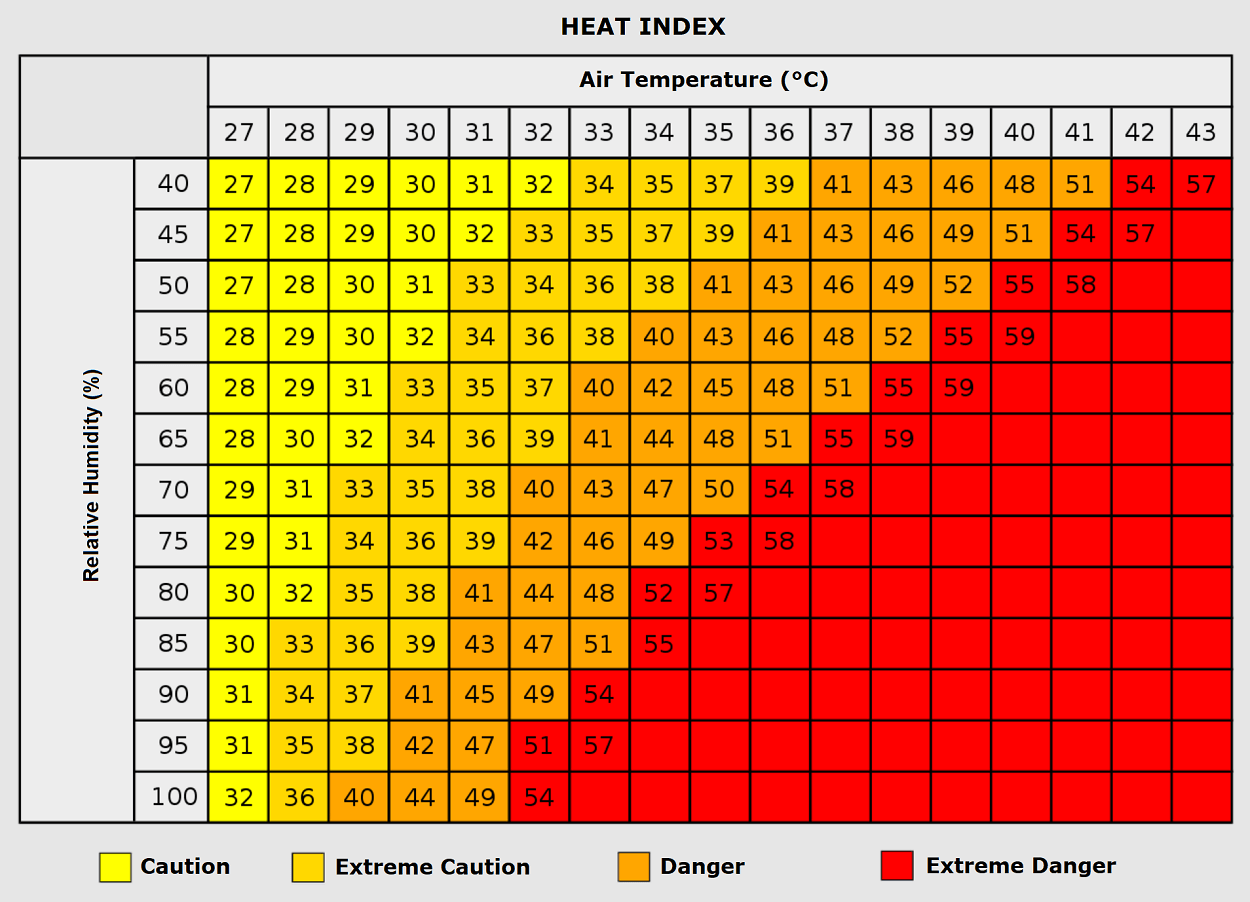
The Iberian Peninsula will face the most extreme conditions. With clear skies and the core of the heat dome overhead, Spain and Portugal will see temperatures between 34°C and 38°C through the weekend. These conditions are exceptionally dry, which, while reducing the heat index compared to humid heatwaves, presents a significant risk for wildfires and agricultural stress.
Western Europe: France and the Benelux
France is projected to experience a secondary peak of the heatwave. Central and Southern France will see temperatures climb into the mid-30s. Northern France and the Benelux countries will follow, with temperatures hovering in the low 30s as the weekend progresses.
Central Europe and the Balkans
As the ridge slides eastward, countries such as Germany, Italy, and the Balkan states will see a delayed but pronounced impact. In the Po Valley of Italy and across the northern Balkans, temperatures are expected to reach 28°C to 30°C, potentially challenging late-September records.
The Atlantic Contrast: The "Atmospheric River"
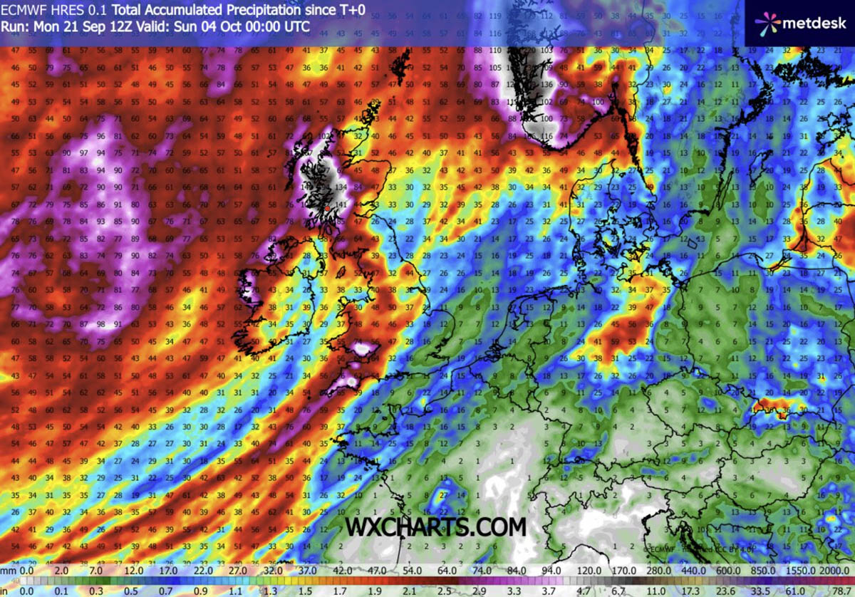
While the continent swelters, the Atlantic boundary remains volatile. The sharp pressure gradient between the heat dome and the deep trough over the Atlantic is facilitating an "atmospheric river" of moisture. This means that while Europe experiences heat, the western British Isles, Ireland, and southwestern Norway will face significant, persistent rainfall, with some regions expected to receive over 150mm of rain.
Implications: Health and Societal Stress
The risks posed by a heat dome are multifaceted. The most immediate concern is human health, particularly for the elderly, children, and those with pre-existing cardiovascular or respiratory conditions.
The Threat of "Tropical Nights"
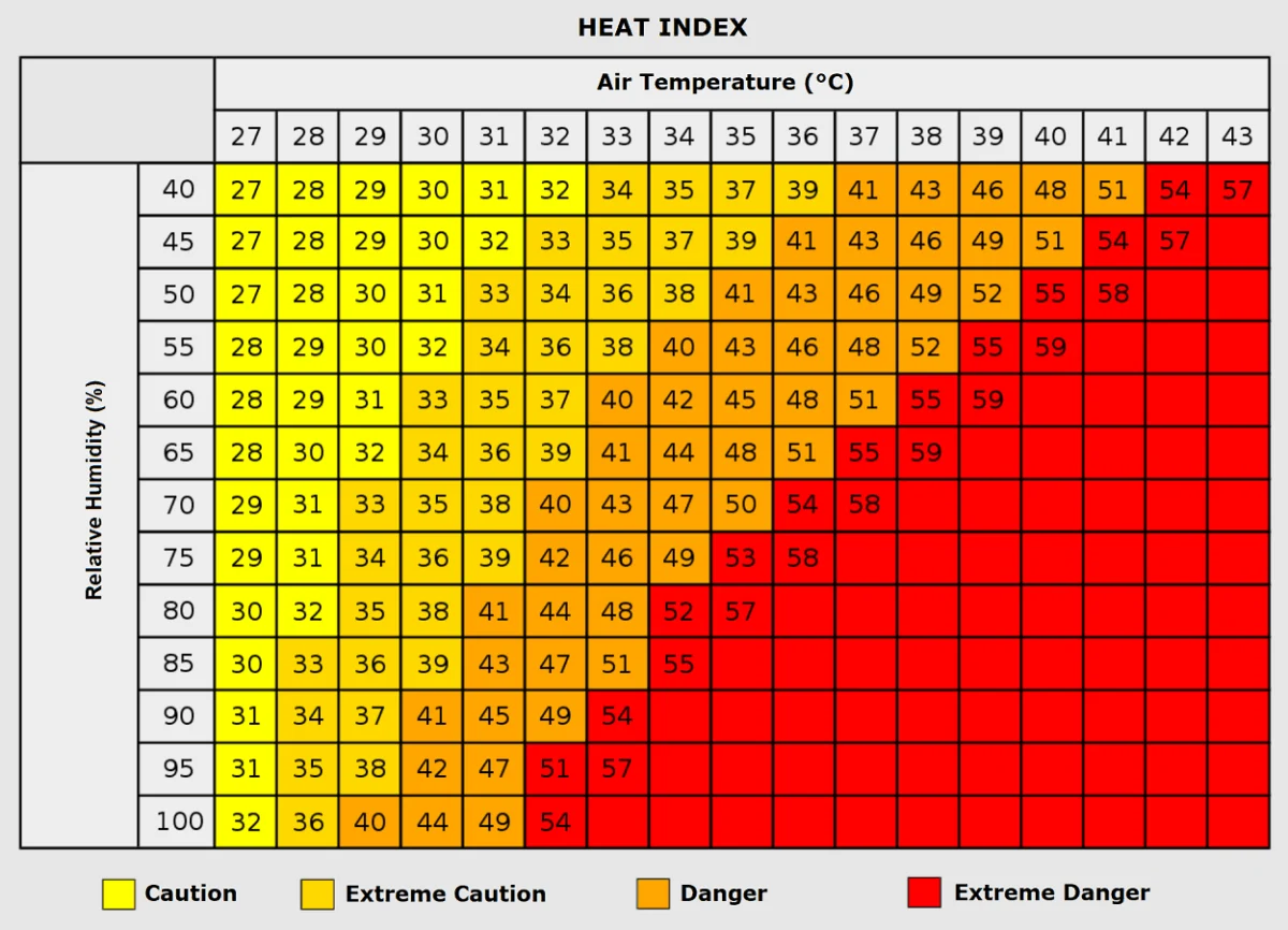
Perhaps the most dangerous aspect of this event is the lack of nocturnal cooling. Meteorologists are warning of "tropical nights," where temperatures refuse to drop below 24°C. This is a critical threshold; the human body requires a drop in temperature during the night to recover from the stress of the day. When the temperature remains high overnight, the cumulative physiological strain increases exponentially, raising the risk of heat exhaustion and heat stroke.
Infrastructure and Urban Heat Islands
Urban environments are particularly vulnerable due to the "heat island" effect. Concrete, asphalt, and other building materials absorb solar radiation throughout the day and radiate it back into the atmosphere at night, preventing the city from cooling down. Residents in lower-income housing, which often lacks adequate ventilation or cooling systems, are at the highest risk.
Agricultural and Economic Impacts
For the agricultural sector, this unseasonable heat comes at a critical juncture in the harvest season. While the dry air may assist in some harvesting activities, the lack of precipitation combined with high temperatures can lead to soil moisture depletion, affecting winter crop planting cycles.
Official Responses and Public Safety Recommendations
While no singular "official" pan-European response exists, national meteorological services across France, Spain, and Germany have begun issuing localized heat advisories. Authorities recommend:
- Hydration: Maintaining consistent fluid intake, regardless of physical activity levels.
- Strategic Cooling: Keeping homes closed during the hottest part of the day to trap cooler morning air, and ventilating only during the late night or early morning hours.
- Vulnerable Populations: Checking on elderly neighbors and those living alone, as they are the most susceptible to the rapid onset of heat-related illnesses.
- Workplace Safety: For those in construction and agriculture, implementing mandatory shade breaks and shifting labor hours to the cooler early-morning windows.
Conclusion: A Sign of a Changing Climate?
As we look toward the remainder of October, the long-range outlook suggests that the atmospheric blocking pattern will eventually become more dynamic, signaling an end to the extreme heat. However, the occurrence of such a robust heat dome so late in the calendar year is a topic of intense interest among climate scientists.
While individual weather events are influenced by natural variability, the frequency and intensity of these "heat domes" are becoming a hallmark of a changing climate. The persistence of these ridges, coupled with the increasing baseline temperatures across the European continent, creates a new reality where late-season heatwaves are no longer the anomaly, but a recurring challenge that society must learn to navigate.
For now, the focus remains on the week ahead. Residents across Europe are advised to monitor their local meteorological updates, as the situation remains fluid and the heat dome continues to evolve. Whether in the sweltering valleys of Spain or the unseasonably warm urban centers of Northern Europe, the message is clear: autumn has arrived, but summer refuses to leave.