An unforgiving atmospheric furnace is setting its sights on the Iberian Peninsula, with an excessive heatwave threatening to push temperatures into a staggering and potentially record-shattering 45°C to 47°C range this week. As a stubborn "heat dome" of high pressure anchors itself over Southwestern Europe, meteorologists are warning that Spain and Portugal are facing one of the most intense and dangerous early-summer thermal anomalies in recent history. This event is not merely a standard summer warm-up; it is a manifestation of an extreme surge of superheated air drawn directly from the Sahara Desert, testing the limits of human endurance, public health infrastructure, and regional ecosystem stability.
The Mechanics of the Heat Dome: A Lid on the Peninsula
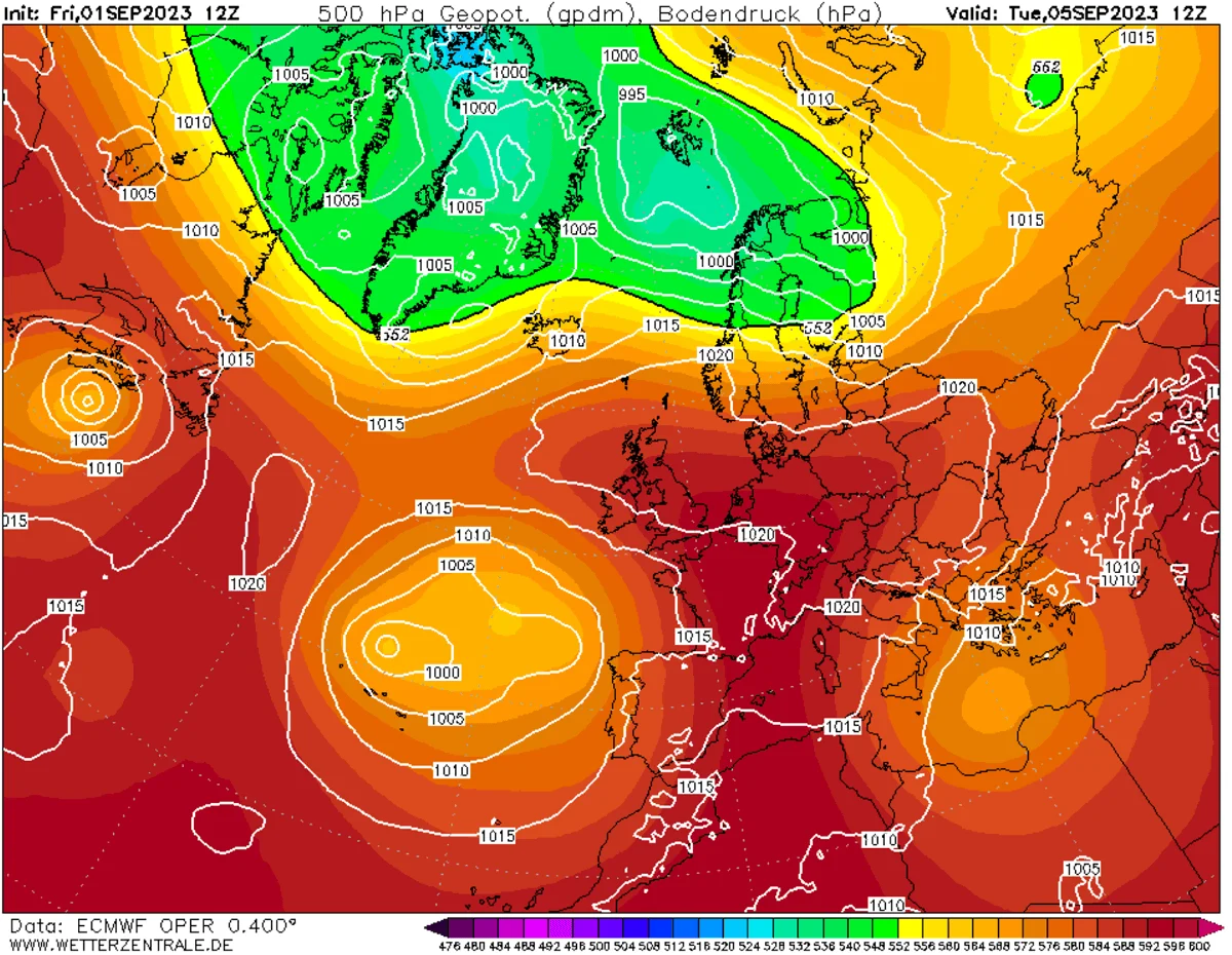
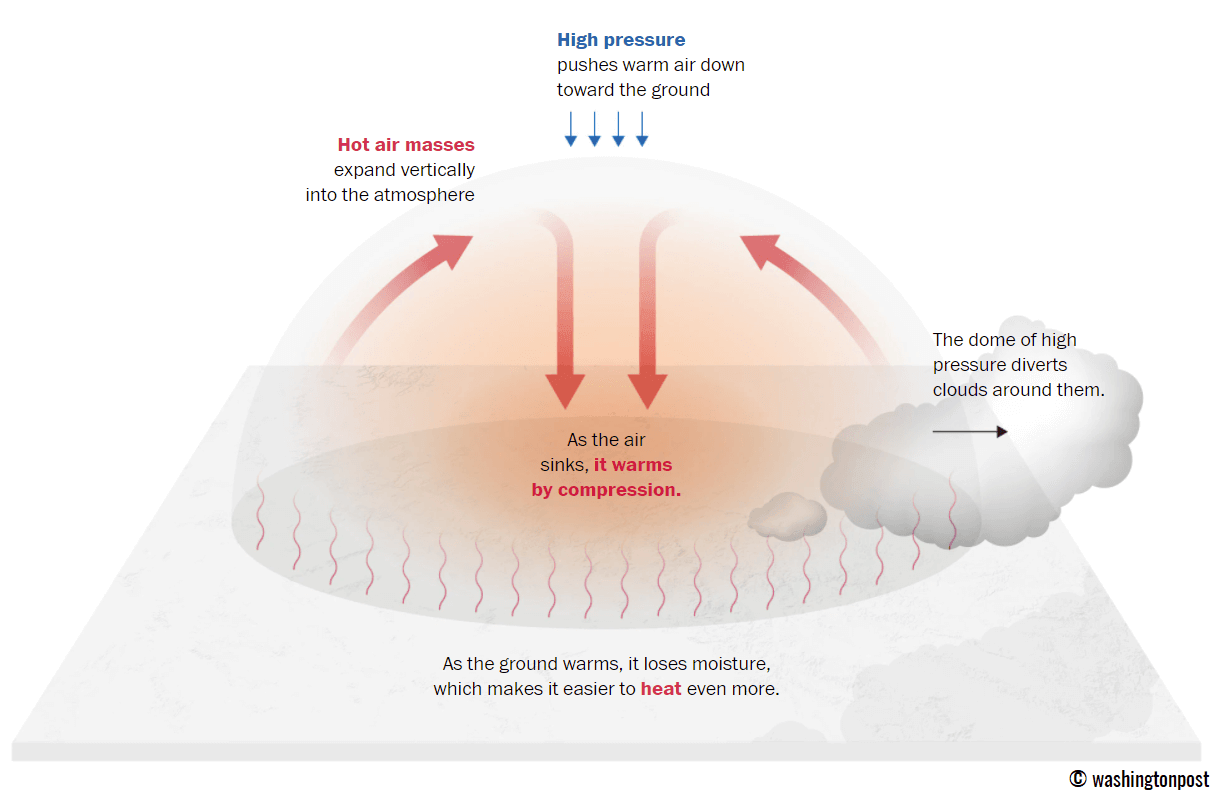
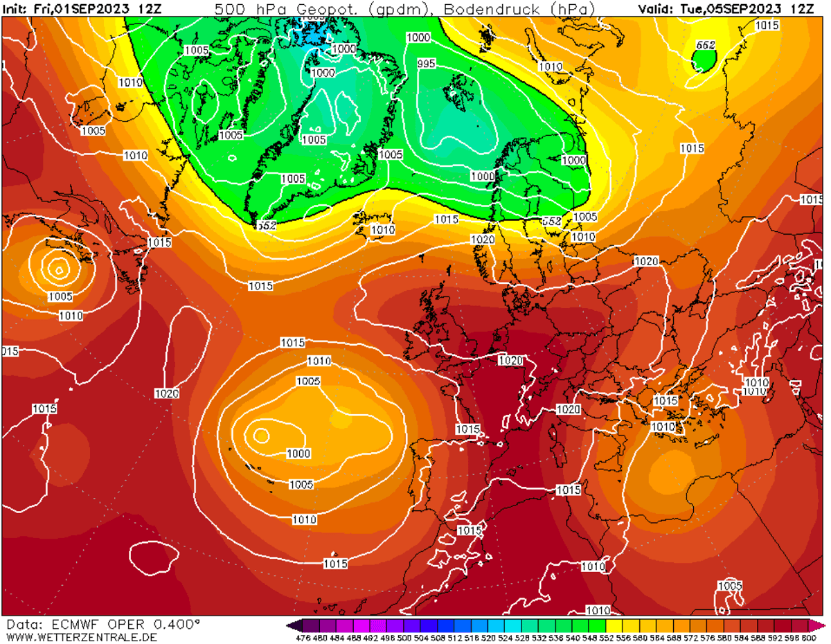
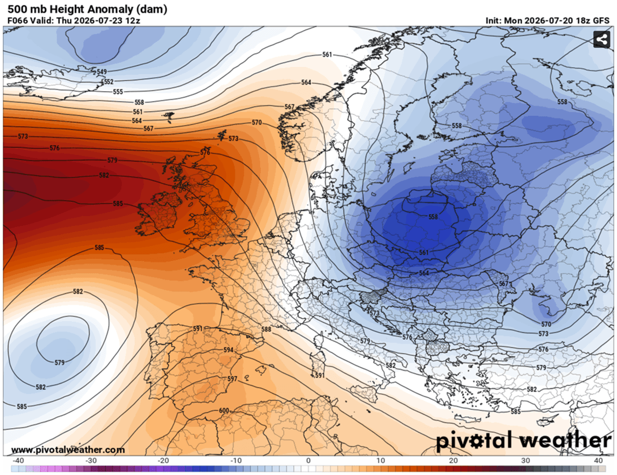
The primary driver of this extreme event is a robust atmospheric blocking pattern—a classic "heat dome"—anchored directly over Southwestern Europe. This meteorological phenomenon functions much like a lid on a pot: a broad, high-pressure ridge parks itself over a large portion of the continent, trapping warm air at all levels. As the air sinks toward the ground, it compresses and warms further, creating a cycle of stagnant, sweltering conditions that can persist for days or even weeks.

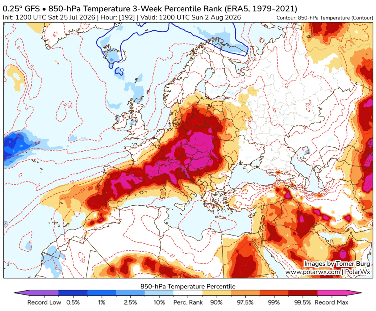
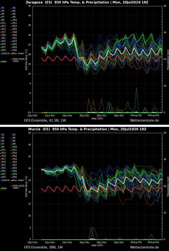
This specific dome is being reinforced by a cut-off low-pressure system to the west, creating a synoptic "conveyor belt" that pumps exceptionally hot, dry air masses straight from the heart of the Sahara across the Iberian Peninsula. Meteorologists note that temperatures at the 850 mbar level—a key metric for measuring air mass temperature—are expected to exceed 30°C, a value rarely seen in this region. This implies surface temperatures 10°C to 15°C above the late-July norm.
Localized Dynamics: Why the Heat Intensifies
While the synoptic pattern provides the heat, the Iberian Peninsula’s unique geography acts as a catalyst for extreme spikes. As winds sweep across the peninsula, they encounter interior plateaus and mountain ranges. When this air is forced to descend rapidly toward the eastern and southern plains, it undergoes adiabatic warming.
This process, known as the "foehn effect," strips the air of any remaining moisture and supercharges the temperature. This is why regions such as the Guadalquivir and Ebro valleys, as well as the provinces of Murcia and Castilla-La Mancha, are poised to record the most extreme thermal spikes. In these basins, the heat is not just ambient; it is pressurized and dry, creating an environment where temperatures can jump by several degrees in a matter of hours.
Chronology of the Thermal Surge
The progression of this heatwave is rapid, with peak intensity expected to manifest between Wednesday and Friday.
- Wednesday: Forecast models from GFS and ARPEGE indicate temperatures reaching 42°C to 44°C across central Spain and the southern lowlands. For the rest of the peninsula, including parts of Portugal, residents should anticipate peak afternoon temperatures between 34°C and 40°C.
- Thursday: The air mass will intensify significantly as the ridge axis parks itself more firmly over the region. Central Spain will likely climb into the low 40s, while the eastern and southern lowlands are projected to hit the 44°C to 46°C range. In the provinces of Murcia, Alicante, and Valencia, localized valleys may push toward the 47°C threshold.
- Friday: While some western regions may begin to see relief as Atlantic moisture begins to filter in, the southern and eastern lowlands, along with the Ebro Valley, will experience one final, brutal day of heat with peaks near 45°C. By the weekend, the heat dome is expected to shift, allowing for a gradual cooling, particularly in Portugal, where temperatures may drop into the high 20s or low 30s.
Historical Context and Record-Breaking Potential
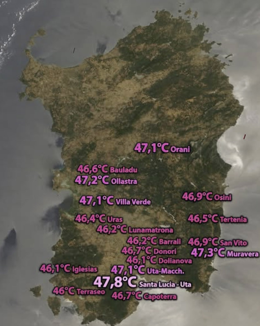
Spain is no stranger to heat, but this event threatens to rewrite the record books. The current official Spanish record stands at 47.6°C, recorded at La Rambla in the Córdoba countryside. Nearby, stations such as Montoro and Córdoba Airport have historically recorded temperatures of 47.4°C and 46.9°C, respectively.
To put this into a broader European context, the continental record is 48.8°C, observed in Syracuse, Sicily, on August 11, 2021. The proximity of the upcoming forecast to these values—only 1.2°C below the European record—highlights the severity of the situation. Murcia, in particular, is being monitored closely as a "record-threat zone," given that the Alcantarilla Air Base set a benchmark of 47.0°C in August 2021. Other regions, such as Castilla-La Mancha, which saw highs of 45.5°C in 2021, are also on the precipice of eclipsing their historical peaks.
Implications: Public Health and Economic Strain
The consequences of this prolonged thermal peak extend far beyond physical discomfort. The combination of intense daytime heat and a lack of overnight relief—with nighttime lows remaining in the mid-to-upper 20s—creates a persistent physiological strain.
Public Health Risks
The most vulnerable populations—the elderly, children, and those with pre-existing cardiovascular or respiratory conditions—are at the highest risk for heat-related illnesses, ranging from heat exhaustion to life-threatening heat stroke. Medical authorities are urging the public to avoid outdoor activity during the peak hours of 12:00 PM to 7:00 PM and to maintain rigorous hydration protocols.
Infrastructure and Industry
- Agriculture: Farmers are bracing for the potential of crop stress and irrigation system failure. The rapid evaporation rates caused by the dry, hot air can lead to severe moisture deficits in soil, threatening seasonal harvests.
- Energy: The demand for electricity will likely reach seasonal highs as residential and commercial cooling systems run at maximum capacity, putting pressure on the regional power grid.
- Fire Risk: Perhaps the most immediate and dangerous implication is the explosive wildfire risk. The combination of extreme heat, very low relative humidity, and dry, gusty winds creates the perfect conditions for the rapid ignition and spread of wildfires. Authorities across Spain and Portugal have issued high-alert warnings, as even a small spark in such conditions could lead to uncontrollable infernos.
Official Responses and Safety Measures
Governments and meteorological agencies, including AEMET (the State Meteorological Agency of Spain), are currently providing continuous updates to the public. Official guidance focuses on:
- Hydration and Shelter: Promoting the use of public cooling centers and urging citizens to keep their homes shaded during the day.
- Labor Regulations: Strengthening enforcement of safety laws for outdoor workers, including mandatory work stoppages during the hottest parts of the day for construction and agricultural laborers.
- Fire Prevention: Strict bans on the use of machinery or any activities that could produce sparks in rural areas, as well as heightened monitoring by forestry and firefighting services.
Conclusion: A Warming Future
This heatwave serves as a sobering reminder of the changing climate dynamics in Southwestern Europe. The frequency and intensity of these "heat dome" events, fueled by expanding high-pressure ridges and desert-born air masses, are increasingly testing the resilience of modern European infrastructure.
As we monitor the movement of this system toward the end of July, it is clear that the region is in a period of significant vulnerability. While the current forecast suggests the heat will begin to subside by the weekend, the meteorological community remains vigilant, watching for any sign that the dome might shift or stall further, potentially extending the misery for millions. Residents are encouraged to stay tuned to local weather bulletins and heed the advice of civil protection agencies as the peninsula enters this dangerous thermal peak.