Valid: August 27, 2026, 06 UTC – August 29, 2026, 06 UTC
A significant and potentially dangerous meteorological event is unfolding across the European continent. Forecaster Marko Korošec, representing Severe Weather Europe, has issued a comprehensive outlook warning of a multi-day severe weather outbreak scheduled to strike portions of Western and Central Europe from Thursday, August 27, through Friday night, August 28. Residents across a wide swath of the continent—from Eastern France to southwestern Poland—are being advised to prepare for a volatile combination of large to "giant" hail, damaging winds, intense flash flooding, and the potential for tornadic activity.
Main Facts: A Perfect Storm of Atmospheric Instability
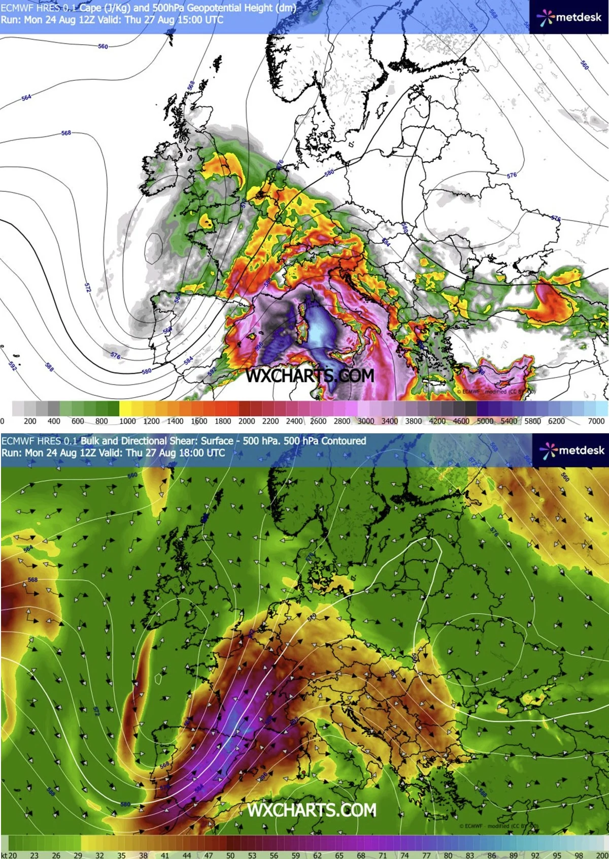
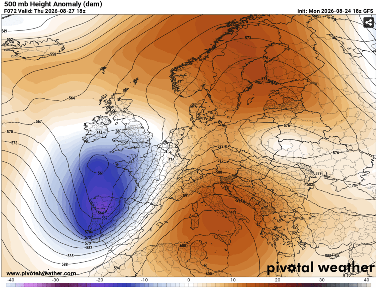
The current atmospheric setup is characterized by a stark contrast between two massive, long-lived weather systems. A deep, robust upper-level trough is currently encroaching upon Western Europe from the Atlantic. Simultaneously, a powerful, persistent blocking High pressure system remains anchored over the Mediterranean region.
This configuration creates a high-pressure gradient that acts as a catalyst for extreme weather. Between these two massive features, a potent southwesterly jet stream is channeling intense wind shear across the continent. When this mechanical forcing meets the extremely humid, warm air mass currently sitting beneath it—fueled by the ongoing, record-breaking Mediterranean heatwave—the result is an environment primed for explosive convective development.
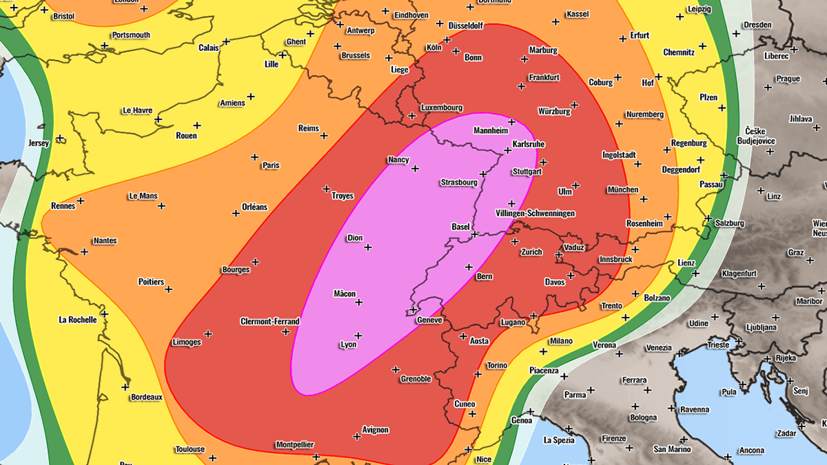
Meteorologists have elevated the threat level to HIGH for parts of Eastern France, Western Switzerland, and Southwestern Germany on Thursday. A MODERATE (MDT) risk has been designated for the second phase of the event on Friday, encompassing the Alpine region, the Czech Republic, and southwestern Poland.
Chronology of the Event
Thursday, August 27: The Initial Surge
The outbreak is expected to initiate Thursday afternoon. As the frontal system pushes inland from the west, the combination of mid-level jet dynamics and surface heating will trigger rapid storm development.
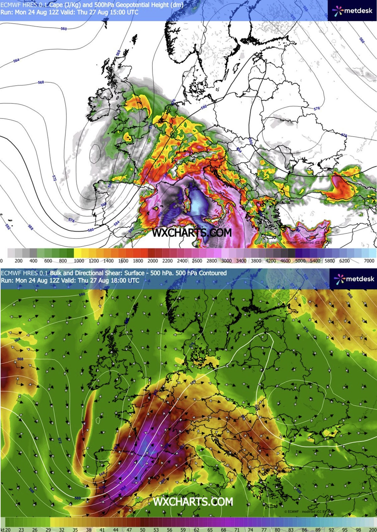
- Midday through Afternoon: Initial convective initiation is expected over the Massif Central in France. As the system tracks toward the Rhône Valley, the influx of moisture from the Mediterranean will lead to high dewpoints and instability indices (MLCAPE) ranging from 2000 to 4000+ J/kg.
- Evening: The storm mode is expected to shift into isolated but intense supercells. These cells carry the highest risk for tornadoes, particularly in the Rhône Valley, where low-level shear and storm-relative helicity will be at their peak.
- Overnight: As the storms track northeast into Southwestern and Central Germany, they are expected to evolve from individual supercells into large, organized clusters. These clusters will bring the secondary threat of wind-driven hail and sustained torrential rainfall.
Friday, August 28: Alpine to Central European Escalation
As the trough shifts eastward, the focus of the severe weather migrates across the Alps and into the heart of Central Europe.
- Early Afternoon: Isolated storms will trigger across the Alpine peaks. While initially scattered, the strong shear will quickly organize these storms into multicells and supercells.
- Late Afternoon to Evening: A critical phase of the event is expected as these storms coalesce into a large Mesoscale Convective System (MCS). Forecasters are particularly concerned about the potential for "bowing segments" within this system, which are notorious for producing swaths of destructive straight-line winds.
- Overnight into Saturday: The system will push into the Czech Republic and southwestern Poland. Models currently indicate the possibility of wind gusts exceeding 120 km/h, which could result in significant structural damage and widespread power outages across the region.
Supporting Meteorological Data
The severity of this event is underscored by the convergence of several high-impact parameters:
- Instability (CAPE): The presence of 2000–4000 J/kg of Convective Available Potential Energy (CAPE) is abnormally high for this region. This acts as the "fuel" for the storms, allowing them to reach immense vertical heights, which is essential for the production of giant hail (6–10 cm or larger).
- Wind Shear: The "left-exit" region of the jet stream is providing intense forcing. This ensures that storms remain tilted and organized, preventing them from collapsing under their own weight and allowing them to persist for hours.
- Low-Level Helicity: In the Rhône Valley and surrounding areas, the directional wind shear—where winds change speed and direction with height—is highly favorable for rotating updrafts, providing the necessary conditions for tornado formation.
- Model Consensus: High-resolution WRF (Weather Research and Forecasting) models have shown consistent agreement regarding the development of the MCS on Friday. While the exact trajectory remains subject to minor shifts, the intensity signals remain firmly in the "destructive" category.
Implications for Public Safety
The threat posed by this system is multifaceted, requiring different mitigation strategies for various regions.
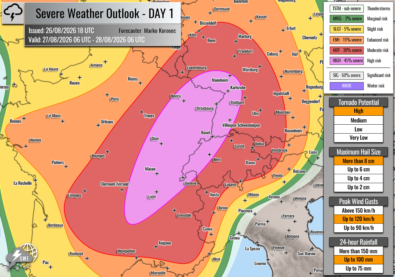
- Tornado Awareness: In the "HIGH" risk zones of France and Switzerland, residents should be prepared for rapid-onset weather changes. Given the speed of the supercells, the window between a warning and a strike may be very short.
- Flash Flooding: Because these storms are expected to drop extreme amounts of rain in a very short period, urban areas with poor drainage and mountainous regions prone to landslides are at elevated risk.
- Infrastructure Impact: The forecast for 120 km/h winds in Central Europe poses a threat to power grids, telecommunications, and aviation. Travelers across the Alps and into Poland should expect significant delays and potential closures of mountain passes and transit corridors.
- Agricultural Damage: With hail sizes predicted to reach 10 cm, the impact on agriculture, greenhouses, and vehicles in the path of the storms will likely be severe.
Official Responses and Recommendations
While national meteorological agencies in the affected countries (including Météo-France, MeteoSwiss, and DWD) are currently finalizing their specific red-alert warnings, the consensus is clear: this is a significant, life-threatening weather situation.
Expert Recommendations:
- Monitor Local Updates: Residents must follow their national meteorological services (e.g., MeteoSwiss, DWD, ČHMÚ) for the most granular, location-specific warnings.
- Secure Property: Loose items in gardens or on balconies should be brought inside. Vehicles should be moved into garages or under shelter to prevent damage from giant hail.
- Avoid Travel: High-profile vehicles, such as trucks and campers, are at high risk of being overturned by straight-line winds during the Friday MCS event. Travel should be avoided during the peak hours of the storms.
- Identify Shelter: Know the safest place in your home or place of work—typically an interior room on the lowest floor, away from windows.
As the situation develops, the scientific community continues to monitor the interaction between the lingering Mediterranean heat and the incoming Atlantic trough. The sheer scale of this system, covering nearly 1,500 kilometers from the French border to the Polish frontier, marks this as one of the most significant convective events of the 2026 summer season.
Data for this report was synthesized from the latest insights provided by Severe Weather Europe, Meteoadriatic, Wxcharts, and PivotalWeather. Further updates will be provided as the trough evolves.