By Mika Rantanen
The summer of 2026 has been defined not by the sweltering heat waves often associated with the season, but by a series of extreme, high-intensity rainfall events. From the destruction of critical infrastructure like bridges to the widespread flooding of urban drainage systems, Finland has faced a volatile meteorological landscape. As climate change continues to alter regional weather patterns, the question is no longer whether these "once-in-a-century" events are possible, but rather how frequently we should expect to encounter them.
While local climatological records suggest that a 100-millimeter daily rainfall is a rare occurrence—statistically expected once every hundred years or even less—the reality on the ground in 2026 suggests a shift. Across the entirety of Finland, such extreme precipitation events are now being recorded with alarming, near-annual frequency.
The Anatomy of an Extreme Event
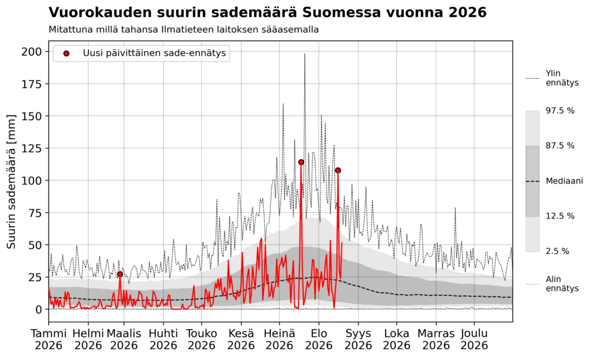
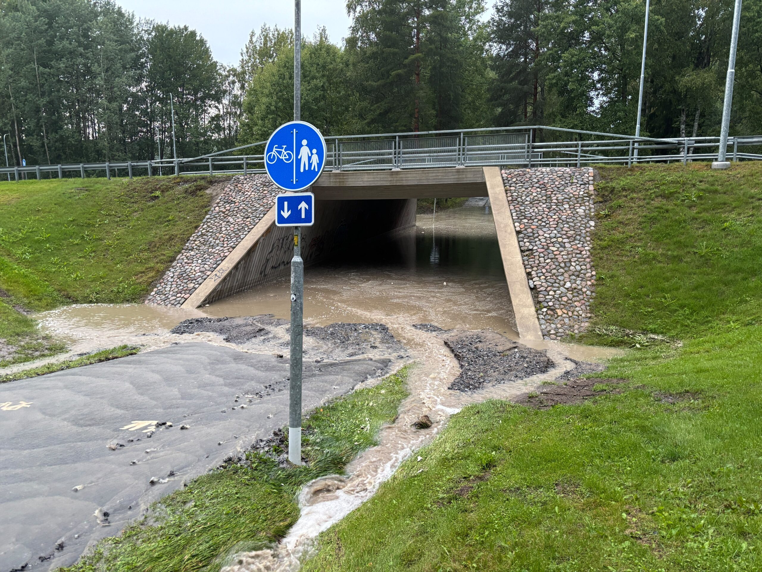
The severity of recent events is best illustrated by the data collected in August 2026. On Sunday, August 16, the town of Pelma, located in Seinäjoki, experienced a staggering 107.7 millimeters of rain within a 24-hour period. Even more critical was the intensity: in just one hour, 68.6 millimeters of rain fell.
To put these figures into perspective, the Finnish Meteorological Institute (FMI) classifies a hourly rainfall of 20 millimeters or a daily accumulation of 50 millimeters as the threshold for a yellow weather warning. The Seinäjoki event far surpassed these markers, reaching levels that would have warranted a red-level warning—the highest category of alert. This was not an isolated incident; on July 18, 2026, the town of Multia also recorded a daily accumulation of 114.2 millimeters.
Chronology of Recent Extremes
The trajectory of the 2026 summer has been marked by these high-impact rainfall events, which have caused significant damage to infrastructure across the country.
- February 2026: A notable winter rainfall event exceeded 25 millimeters, setting a record for that specific date.
- July 18, 2026: Multia recorded 114.2 millimeters of rain, marking a significant threshold breach.
- August 16, 2026: Seinäjoki-Pelma recorded 107.7 millimeters. This event is particularly noteworthy for being the latest occurrence of a 100-millimeter daily rainfall in the recorded history of Finnish meteorology.
These events highlight a transition in how we track precipitation. Historically, extreme daily rainfall in Finland has been confined to the period between late June and mid-August. The national record remains the 198.4 millimeters recorded in Lahnus, Espoo, on July 21, 1944. However, the timing of the recent Seinäjoki event confirms that the "window" for such extreme events remains firmly centered on the peak of summer, yet their intensity is pushing the boundaries of historical datasets.
Statistical Divergence: Local vs. National Perspectives
When analyzing the frequency of 100-millimeter rainfalls, meteorologists approach the problem from two distinct angles: the local probability at a specific location versus the probability of such an event occurring somewhere within the vast borders of Finland.
The Local Context
Using recurrence tables from the Ilmasto-opas (Climate Guide), we can analyze the likelihood of extreme precipitation at specific weather stations. For instance, at the Kauhava airport station, a 100-millimeter daily rainfall has a 100-year return level of approximately 84 millimeters, and a 500-year return level of 114 millimeters. Given that Seinäjoki is geographically close to Kauhava, we can estimate that the recent rainfall was a 100-to-500-year event for that specific location. For an individual, this means such an event is likely to be experienced only once in a lifetime, if ever.
The National Context
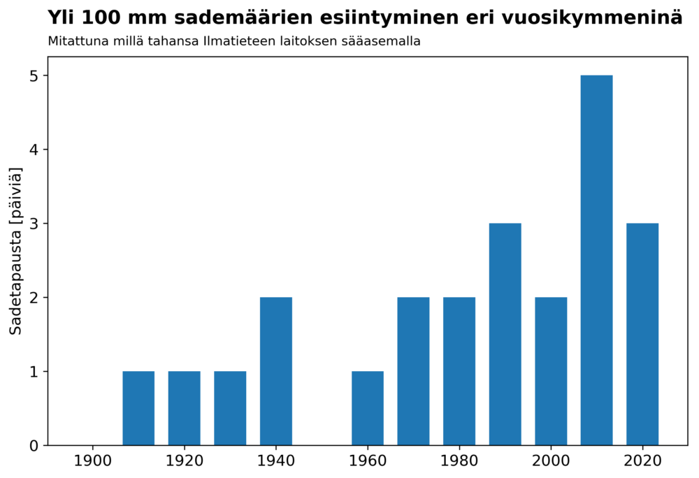
The picture changes drastically when we view Finland as a whole. Thanks to the digitalization of over a century of weather data by the Finnish Meteorological Institute, we have a clearer view of the national trend. From 1910 to 2026, there have been 23 recorded instances where at least 100 millimeters of rain fell in a single day at any given observation station in Finland.
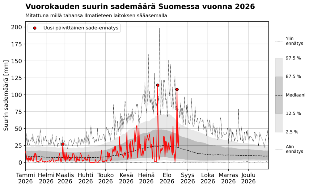
Statistically, this means that a 100-millimeter event occurs somewhere in Finland roughly every five years. However, the distribution of these events is not uniform. While there have been decades with fewer occurrences, the last 17 years have seen a marked increase, with 8 such events recorded—nearly once every two years.
Supporting Data and Historical Trends
The data clearly indicates a shift. When analyzing the frequency of these events by decade:
- 2010–2019: Five recorded events.
- 2020–2026 (partial): Three recorded events.
While researchers must be cautious—as the number of observation stations and the quality of digital records have evolved over the last century—the trend is difficult to ignore. The increase in these events is consistent with climate change models that predict a more volatile hydrological cycle.
It is crucial to differentiate between "rare for a specific point" and "frequent for a nation." While a resident of a specific town might only see a 100-millimeter deluge once in a century, the Finnish nation, as a cumulative geographic entity, is now encountering these extreme events with increasing regularity.
Official Responses and Meteorological Outlook
The Finnish Meteorological Institute has been vocal about the implications of these trends. Recent studies indicate that the frequency of the most intense precipitation events—defined as more than 20 millimeters per hour—is expected to roughly double by the end of the century under the RCP4.5 emission scenario. If global warming exceeds current projections, the frequency of these deluges could increase even more significantly.
The primary driver is simple physics: a warmer atmosphere holds more moisture. According to the Clausius-Clapeyron relation, the water-holding capacity of the atmosphere increases by approximately 7% for every degree of warming. As Finland experiences higher average temperatures, the potential for heavy, convective summer showers increases, leading to the rapid, damaging floods seen in cities like Tampere and Seinäjoki this year.
Broader Implications for Infrastructure and Society
The increasing frequency of these "extreme" events presents a massive challenge for civil engineering and urban planning. Our current infrastructure—sewage systems, bridges, and road drainage—was largely designed based on historical climate norms that are no longer accurate representations of the future.
- Urban Planning: Drainage systems in major Finnish cities are being pushed to their breaking points. The "hulevesi" (stormwater) flooding observed in Tampere and other urban centers illustrates that existing pipe capacities are often insufficient to handle 60+ millimeters of rain in an hour.
- Infrastructure Resilience: The destruction of bridges and washouts of roads indicate that structural integrity standards must be revisited. Building for a "100-year flood" may no longer be a sufficient safety margin if the statistical return period for such events is effectively shortening.
- Economic Impact: The cost of repairing flood-damaged infrastructure is escalating. Municipalities are now faced with the difficult choice of either investing heavily in climate-resilient infrastructure or accepting the recurrent financial burden of disaster recovery.
Conclusion
The data from the summer of 2026 serves as a wake-up call. While the 100-millimeter rainfall remains a rare, localized catastrophe, it is becoming a common, national phenomenon. The shift from a "once-in-a-century" event to a recurring challenge requires a fundamental reassessment of how we build, manage, and protect our environment.
As we move toward the latter half of this decade, the meteorological evidence is clear: the climate is not merely warming; it is becoming more intense. The events of this summer demonstrate that we must transition from reactive disaster management to proactive, climate-resilient development to withstand the increasingly wet future that lies ahead for the Nordic region.