Valid Period: September 9, 2026, 06:00 UTC – September 11, 2026, 06:00 UTC
Issued by: Severe Weather Europe
Lead Forecaster: Marko Korošec
Executive Summary: A Significant Atmospheric Crisis
A high-impact, two-day severe weather outbreak is currently developing across the western and northern Mediterranean basin. Meteorological data indicates a volatile collision between an encroaching deep-layer upper-level trough and the remnants of a persistent, record-breaking marine heatwave. This atmospheric synergy is expected to produce widespread, destructive thunderstorm activity, including the risk of giant hail (6–10 cm), violent convective wind gusts, multiple tornadic events, and life-threatening flash flooding.
The event, which begins in earnest on Wednesday morning, will track from the Balearic Islands across southern France and Northern Italy, before intensifying further as it shifts into Slovenia, Croatia, and the Central Adriatic region by Friday. Residents in these regions are advised to prepare for a multi-faceted weather disaster that combines extreme convective instability with a highly favorable environment for tornadogenesis.

Synoptic Overview: The Mechanics of the Storm
The current meteorological setup is defined by a deep-trough system penetrating Western Europe. As this system moves eastward, it is encountering a collapsing high-pressure ridge over Eastern Europe, creating a potent temperature and pressure gradient.
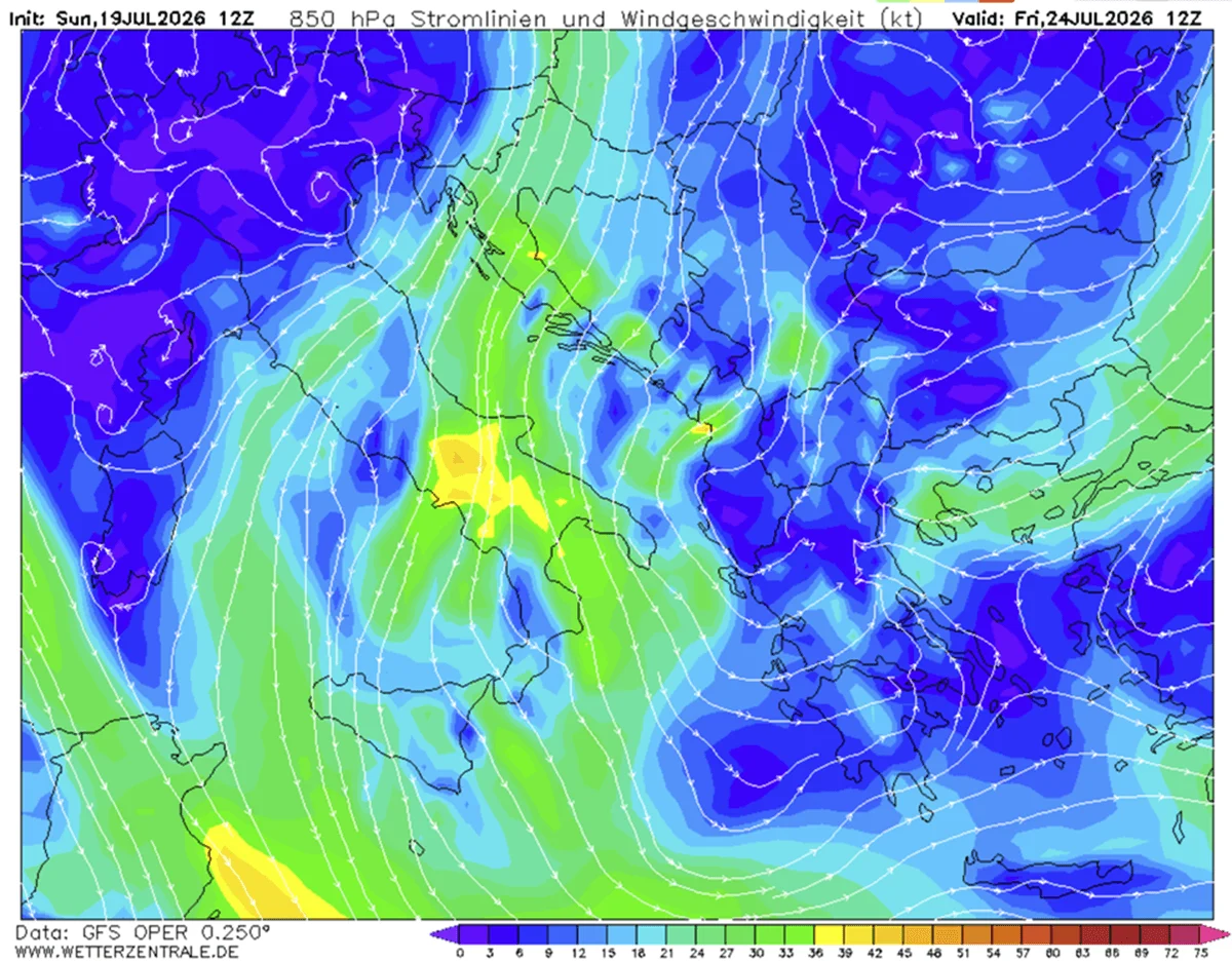
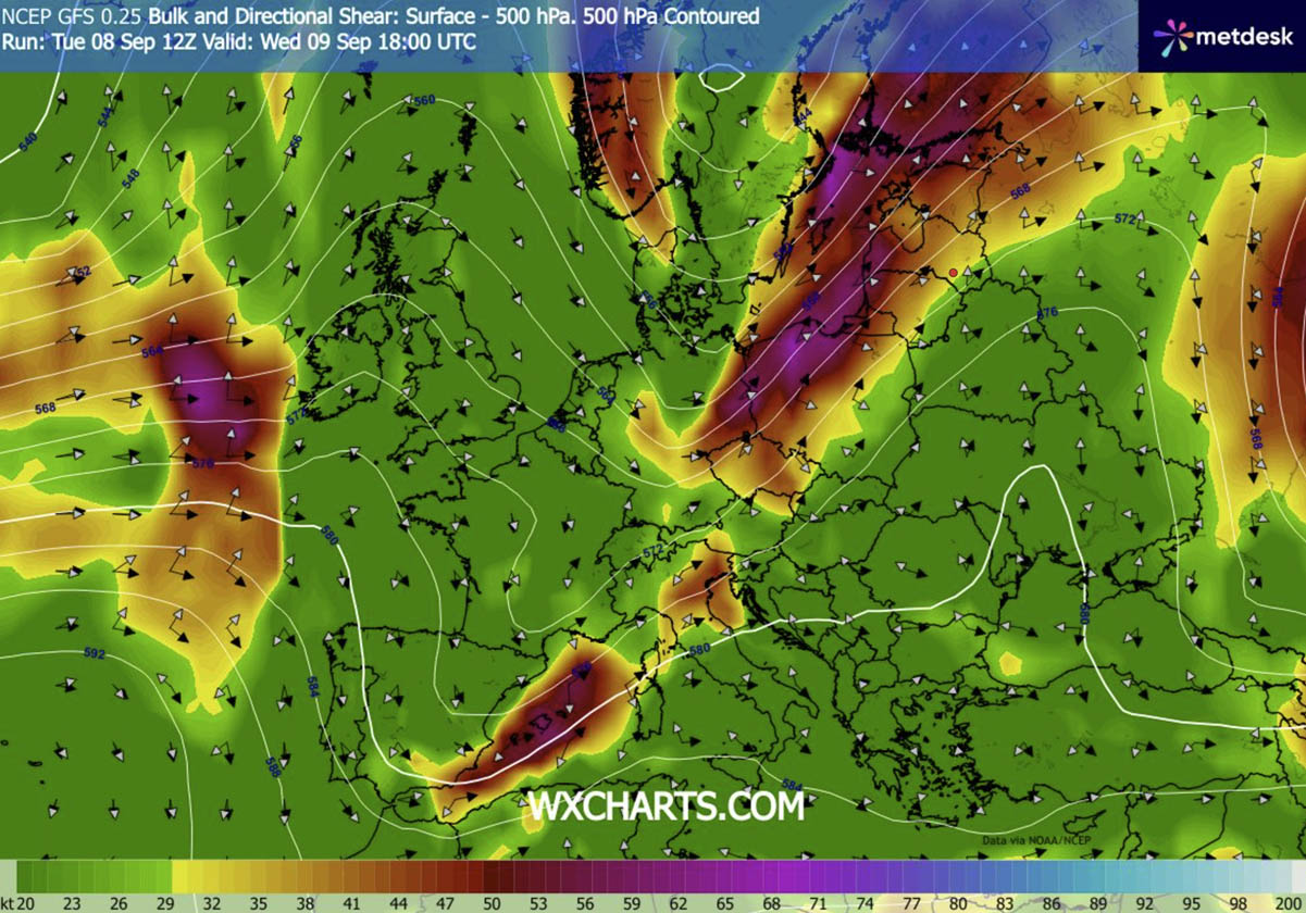
The primary engine for this severe weather is the Mediterranean itself. After a summer defined by historic marine heatwaves, sea surface temperatures are well above seasonal averages, injecting excessive moisture into the lower atmosphere. Dewpoints are projected to reach or exceed 25°C in many coastal zones. When this moisture is coupled with a powerful southwesterly jet stream—which is providing significant wind shear—the result is an environment primed for "explosive" convective development.
Forecasters are particularly concerned about the "left exit region" of the jet stream, which is expected to provide the necessary dynamic forcing to trigger rapid, sustained updrafts along an advancing cold front. This frontal boundary will serve as the primary focal point for storm initiation as it pushes from the Alps and France into the heart of the Italian peninsula.
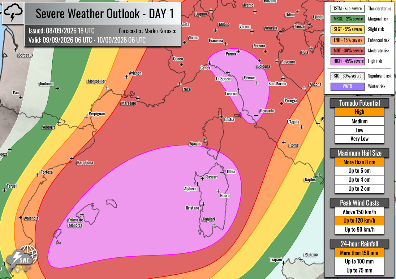
Chronology of the Outbreak
Wednesday, September 9: The Initial Surge
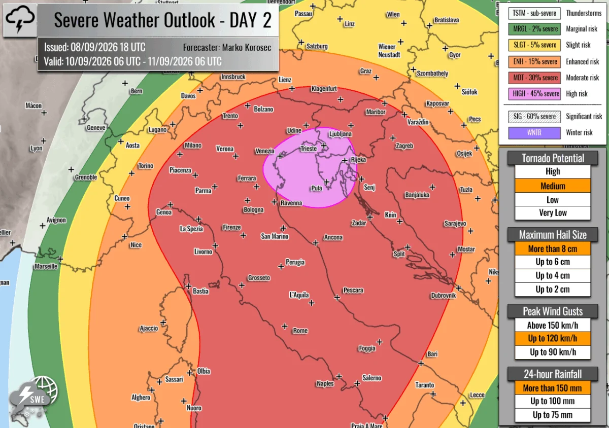
The event begins Wednesday morning, with the Balearic Islands, southern Corsica, Sardinia, and the Italian regions of Tuscany and Liguria placed under a HIGH risk category.
- Morning to Afternoon: As the cold front makes landfall, the combination of MLCAPE (Mixed-Layer Convective Available Potential Energy) values reaching 3,000 to 4,000+ J/kg will trigger intense supercellular development. These isolated, high-intensity storms are expected to produce giant hail, often exceeding 6 cm in diameter.
- Evening: Storms will likely merge into large convective clusters. The primary threat shifts toward destructive wind gusts and localized, intense tornado activity. The Ligurian and Tuscan coastlines are under particular scrutiny for tornadic potential due to the backing of low-level winds along the western Apennines.
- Overnight: The system will push into the Po Valley, where local surface lows may further fuel storm intensity. By late night, the activity will reach western Slovenia and northwestern Croatia, bringing the threat of torrential rainfall and damaging winds to these regions.
Thursday, September 10: The Peak of the Crisis
Thursday marks the intensification of the event as the system interacts with the warm waters of the Adriatic.
- The Northern Adriatic Focus: A HIGH risk has been extended to northeastern Italy, the northern Adriatic, and western Slovenia/northwestern Croatia. The environment here is characterized by sustained, deep-layer wind shear and extreme thermodynamic instability.
- The "Training" Storm Phenomenon: A primary concern for Thursday is the potential for "training" storms—a phenomenon where multiple storm cells pass over the same geographic location in quick succession. Because these storms are moving slowly and feature high precipitable water content, they are capable of dumping 200–300 mm of rain within a 36-hour window.
- Geographic Expansion: The central and southern Adriatic, as well as western Bosnia, are under a MDT (Moderate) risk. While storm coverage may be slightly less widespread than in the core HIGH-risk zone, the individual storms remain capable of producing significant destruction.
Supporting Meteorological Data
The severity of this forecast is underpinned by high-resolution numerical modeling, including data provided by PivotalWeather.
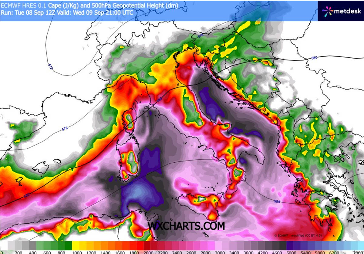
- Instability (CAPE): The extreme CAPE values (3,000–4,000 J/kg) represent a level of energy rarely seen in European autumn weather. This energy acts as fuel for the updrafts, allowing them to overcome atmospheric resistance and reach the tropopause with great velocity.
- Wind Shear: The presence of a strong mid-level jet stream ensures that the updrafts are not only energetic but also tilted. This tilting prevents the storm from raining itself out (a process known as precipitation loading) and allows for the rotation that leads to supercells and tornadoes.
- Low-Level Helicity: The specific configuration of surface winds (southerly/southeasterly) combined with the upper-level flow creates a high-helicity environment. This is the specific "spin" in the atmosphere required for tornadogenesis, particularly in the coastal zones of the Balearic Islands and the Ligurian Sea.
Official Responses and Public Safety
National meteorological services across Italy, Slovenia, and Croatia are expected to escalate their color-coded warning systems as the front approaches.
- Infrastructure Warnings: Authorities are highlighting the danger of "destructive flash floods." Given the prolonged drought conditions experienced in many of these regions, the soil may be hardened or hydrophobic, leading to rapid runoff rather than absorption.
- Agricultural Impact: The agricultural sectors in Northern Italy and the Balkans face a high probability of significant crop loss due to the predicted giant hail, which can decimate vineyards and orchards in minutes.
- Public Guidance: Emergency management agencies are urging residents to:
- Secure outdoor property and equipment.
- Monitor local government weather alerts continuously.
- Identify safe rooms in their homes, ideally away from windows and on the lowest level, in the event of a tornado warning.
- Avoid low-lying areas or drainage basins, which are highly susceptible to flash flooding.
Implications: A Warning for a Changing Climate
The intensity of this forecast serves as a grim reminder of the changing meteorological landscape in the Mediterranean. The combination of an unseasonably warm sea—a direct consequence of the marine heatwave—and a volatile atmospheric trough creates a "perfect storm" scenario.
Historically, such significant outbreaks were rare in early September. However, the consistent warming of the Mediterranean serves as a heat reservoir that can turn a standard autumn cold front into a life-threatening, multi-day severe weather event. This event is not merely a localized thunderstorm outbreak; it is a systematic test of the region’s infrastructure, which must now cope with higher precipitation totals and more violent convective modes than in previous decades.
As the system progresses through Friday, the aftermath will likely reveal significant damage to power grids, transport infrastructure, and residential housing. Recovery efforts will depend heavily on the accuracy of real-time monitoring and the swiftness of emergency response teams deployed across the impacted Adriatic corridor.
Residents are strongly encouraged to treat this event with extreme caution. The combination of giant hail, widespread tornadoes, and extreme flash flooding creates a threat profile that necessitates immediate readiness and proactive safety measures.