As the calendar turns to September, most of Europe typically prepares for the gentle transition into autumn. However, 2026 is delivering a starkly different meteorological reality. A powerful and expansive "Heat Dome" is currently establishing itself over the Mediterranean Basin, triggering an intense, late-season heatwave that threatens to shatter temperature records across the continent. With surface temperatures forecast to climb into the upper 30s and locally exceed the 40°C threshold, meteorologists are sounding the alarm on a period of prolonged thermal stress.
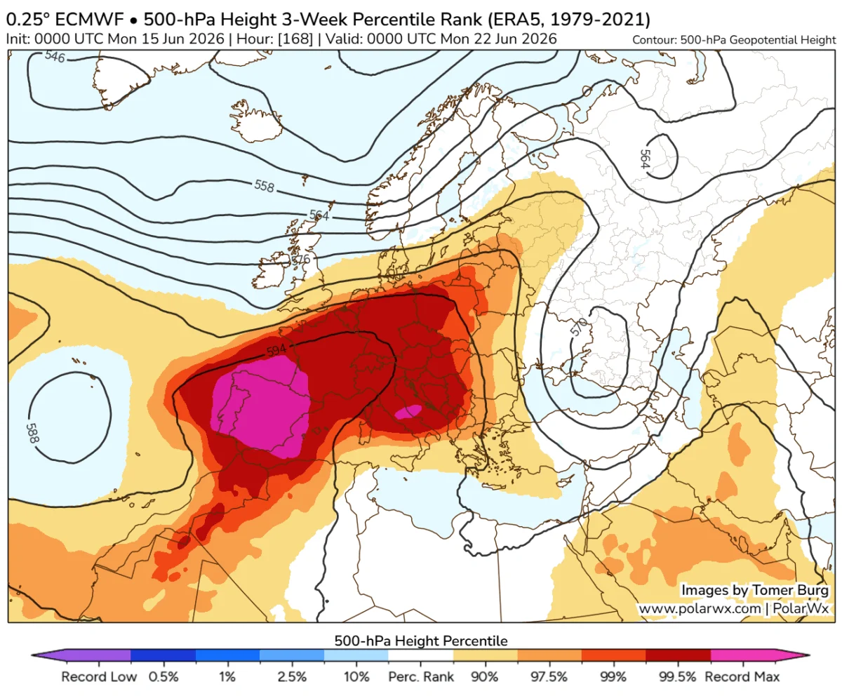
This extreme weather event is being driven by a massive, high-pressure ridge surging northward from North Africa. As this atmospheric blocking pattern locks into place, it acts as a lid on a pot, trapping stagnant, scorching air over Spain, France, Italy, and the Balkan Peninsula. The persistence of this system is expected to keep the region in a sweltering grip through the middle of next week.
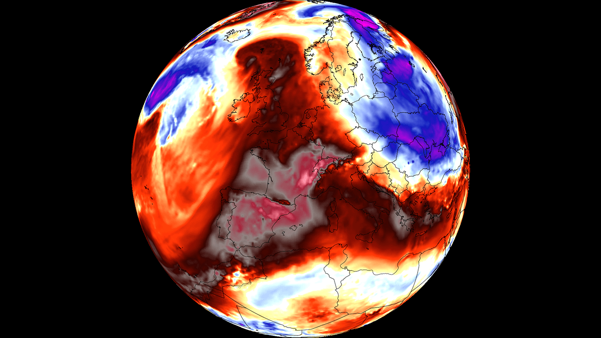
The Synoptic Setup: Anatomy of an Atmospheric "Lid"
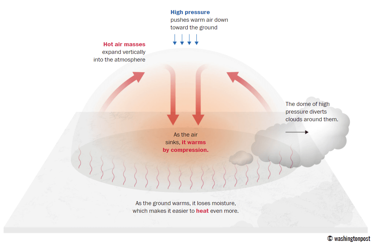
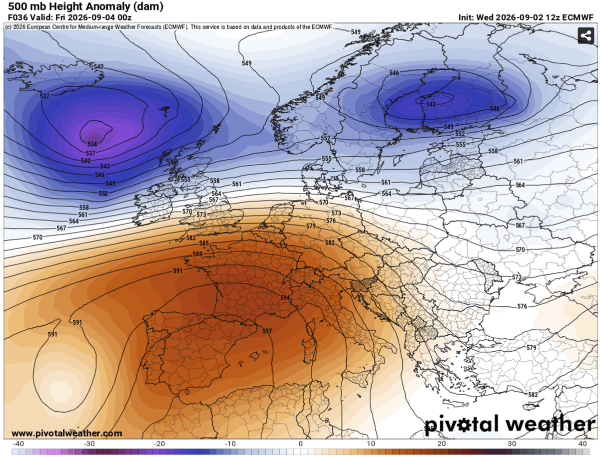
To understand the severity of the current situation, one must look at the synoptic-scale dynamics at play. A heat dome is not merely a "hot day"; it is a complex atmospheric structure. It occurs when a persistent, high-pressure system parks itself over a large geographic area, preventing the normal movement of weather fronts.
As this upper-level ridge settles over Europe, the air beneath it is subjected to a process called adiabatic compression. As the high pressure forces air to sink, the air mass is compressed and naturally warms, creating a feedback loop of rising surface temperatures. Because the system is stationary, it prevents cooler, maritime air from the Atlantic from penetrating the continent, effectively "baking" the landscape beneath it.
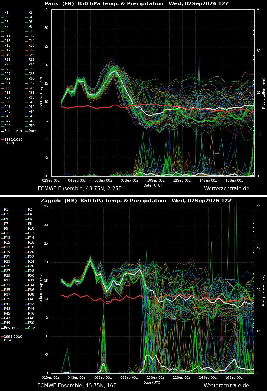
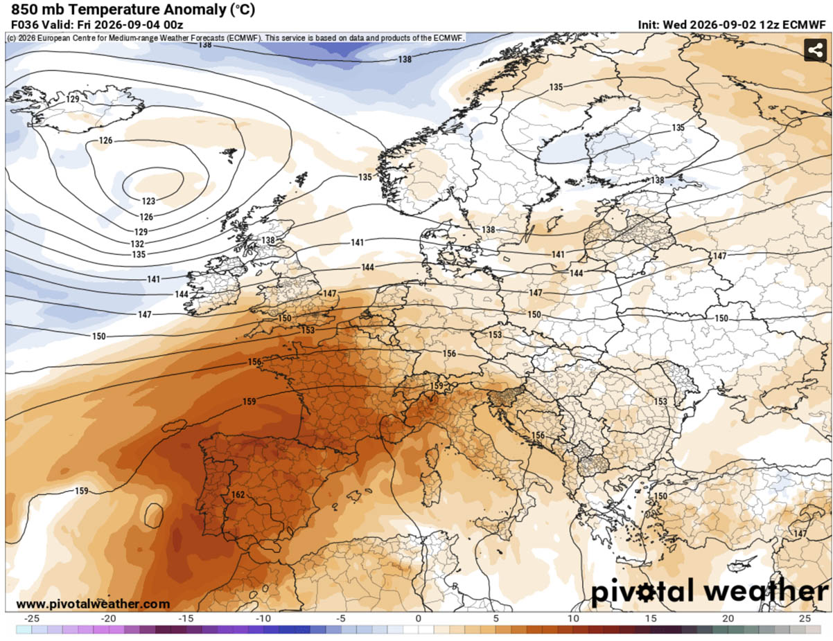
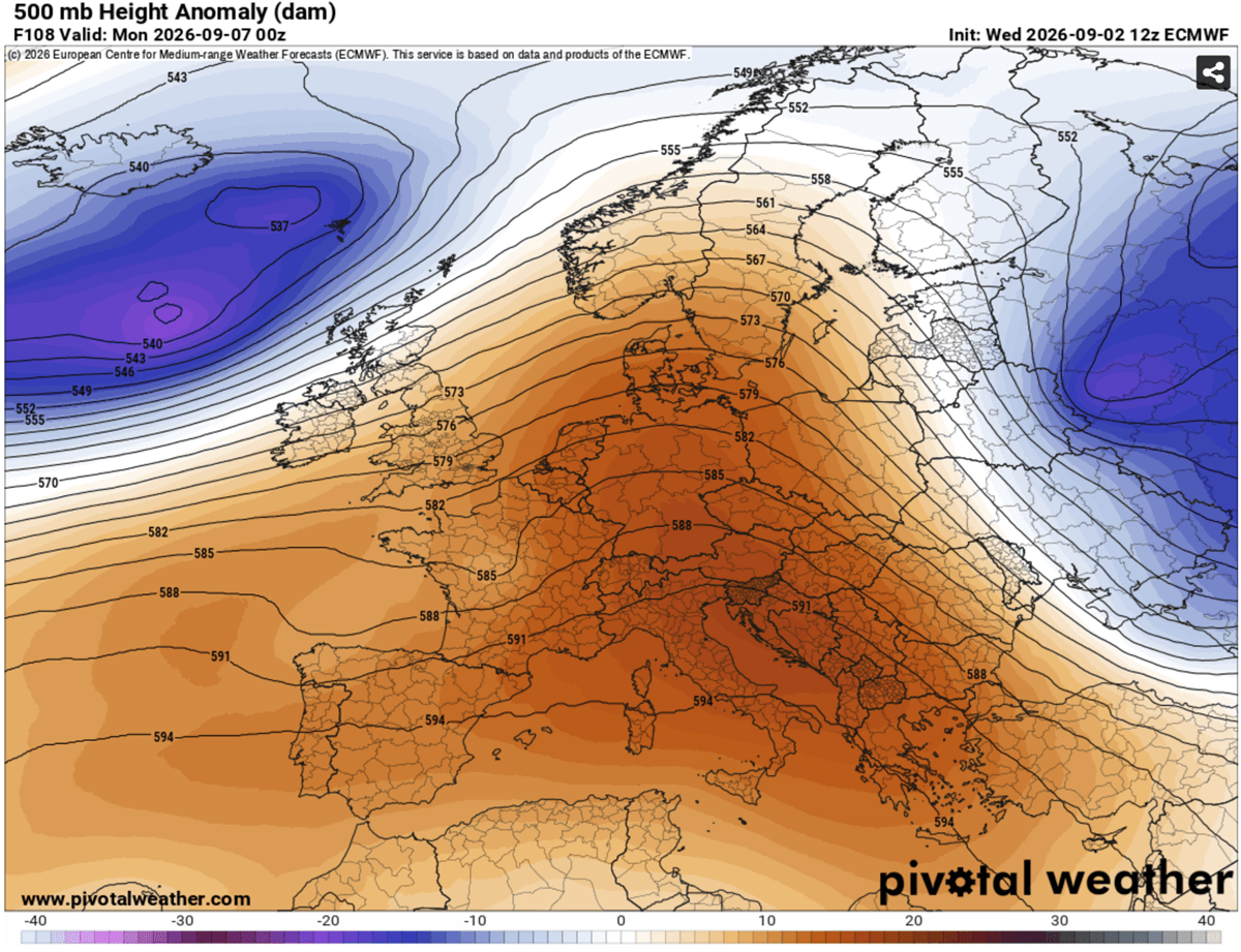
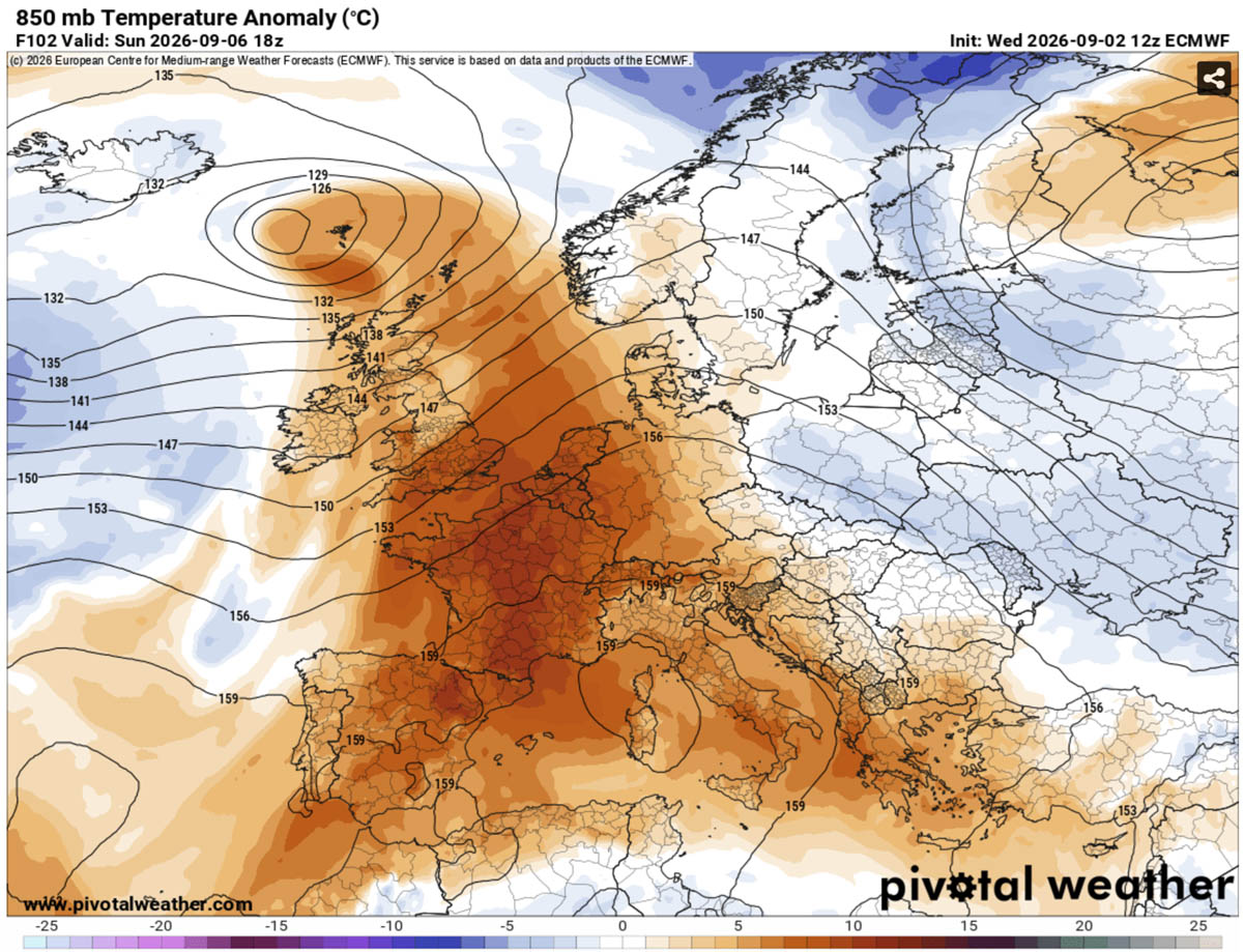
Current model animations show the core of this ridge intensifying over the Mediterranean, with 850 hPa temperature anomalies—a key metric for measuring air mass intensity—climbing significantly above seasonal norms. By the end of this weekend, the ridge is expected to expand further north and east, extending the reach of the heatwave into the heart of Central Europe.
Chronology of the Heatwave: A Multi-Phase Expansion
The progression of this heatwave is structured into three distinct phases as the ridge migrates:
Phase 1: The Iberian Surge (Thursday – Friday)
The initial brunt of the heat is focused on the Iberian Peninsula. Portugal and central-southern Spain are currently experiencing temperatures ranging from 38°C to 44°C. The air mass is exceptionally dry, which, while reducing humidity, significantly elevates the risk of rapid soil moisture depletion and wildfires.
Phase 2: The Continental Expansion (Saturday – Monday)
Over the weekend, the heat dome will shift its focus toward Western and Southern Europe. France, particularly the southern and central departments, will see temperatures climb back toward the 40°C mark. Simultaneously, the heat will pour into Italy and the central Balkans. In the Po Valley and Tuscany, residents are bracing for peak temperatures between 38°C and 41°C, potentially setting new September records.
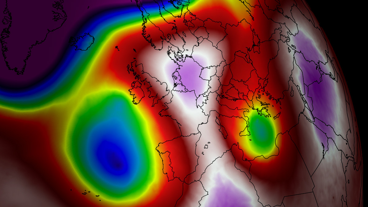
Phase 3: The Pattern Shift (Mid-Next Week)
Forecast models indicate that the reign of the heat dome will be challenged by the middle of next week. A deep, cold-air mass originating in the North Atlantic is expected to push against the ridge. This transition is projected to be significant, likely ending the stagnant heat with a period of cooler temperatures, increased cloud cover, and much-needed rainfall for drought-parched regions.
Regional Breakdown: Where the Heat Hits Hardest
The impact of this heatwave is not uniform; geography plays a critical role in the intensity of the thermal load.
- Southwestern Europe: This region remains the "ground zero" of the event. The sustained 40°C+ temperatures in Spain and Portugal are anomalous even for mid-summer, let alone early September. The heat here is characterized by low humidity, creating a high fire-danger environment.
- France: Southern and central France are currently under a high-alert status. The interior valleys are expected to trap heat effectively, with daytime highs staying in the mid-to-high 30s. Northern France and the Benelux region will experience a milder version of the heat, with temperatures peaking in the high 20s.
- Italy and the Balkans: These areas are facing a delayed peak. The heat is expected to be particularly oppressive in the Po Valley, where high humidity levels combined with high temperatures could drive the "feels-like" temperature toward 45°C.
- United Kingdom: While spared the worst of the extreme heat, the UK will still feel the influence of the ridge. South-central England and Wales will see temperatures reach the mid-to-upper 20s through Sunday—significantly warmer than the historical September average for the region.
The Silent Threat: Nocturnal Heat Stress and Health Implications
One of the most dangerous aspects of this heatwave is the lack of nocturnal relief. Meteorologists are monitoring for the development of "tropical nights," where overnight low temperatures remain at or above 24°C.
Human health relies on the body’s ability to cool down during the night. When nighttime temperatures remain excessively high, the human body cannot recover from the thermal stress accumulated during the day. This is particularly lethal for the elderly, those with cardiovascular conditions, and individuals living in urban "heat islands"—areas characterized by high concentrations of concrete and asphalt that absorb and re-radiate heat long after the sun has set.
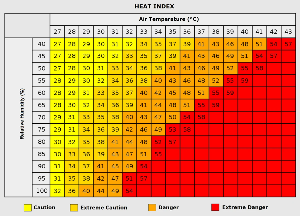
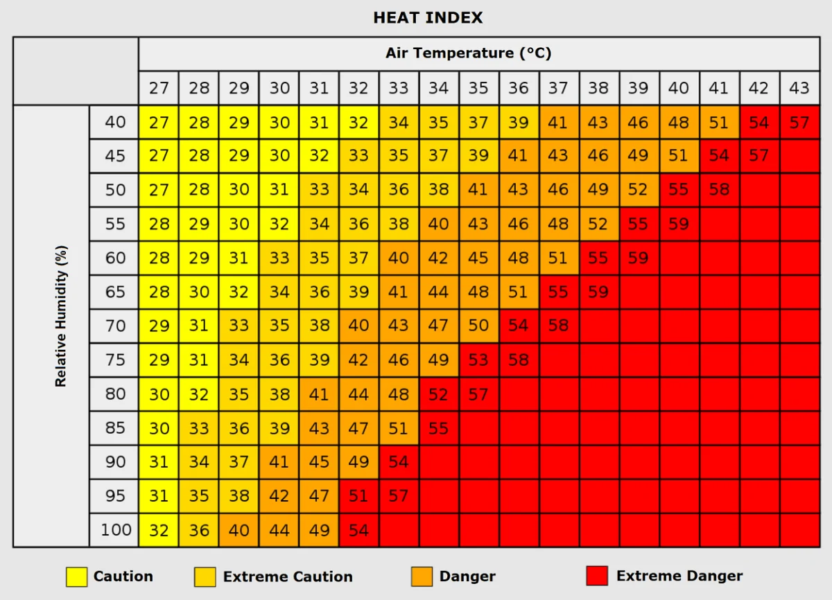
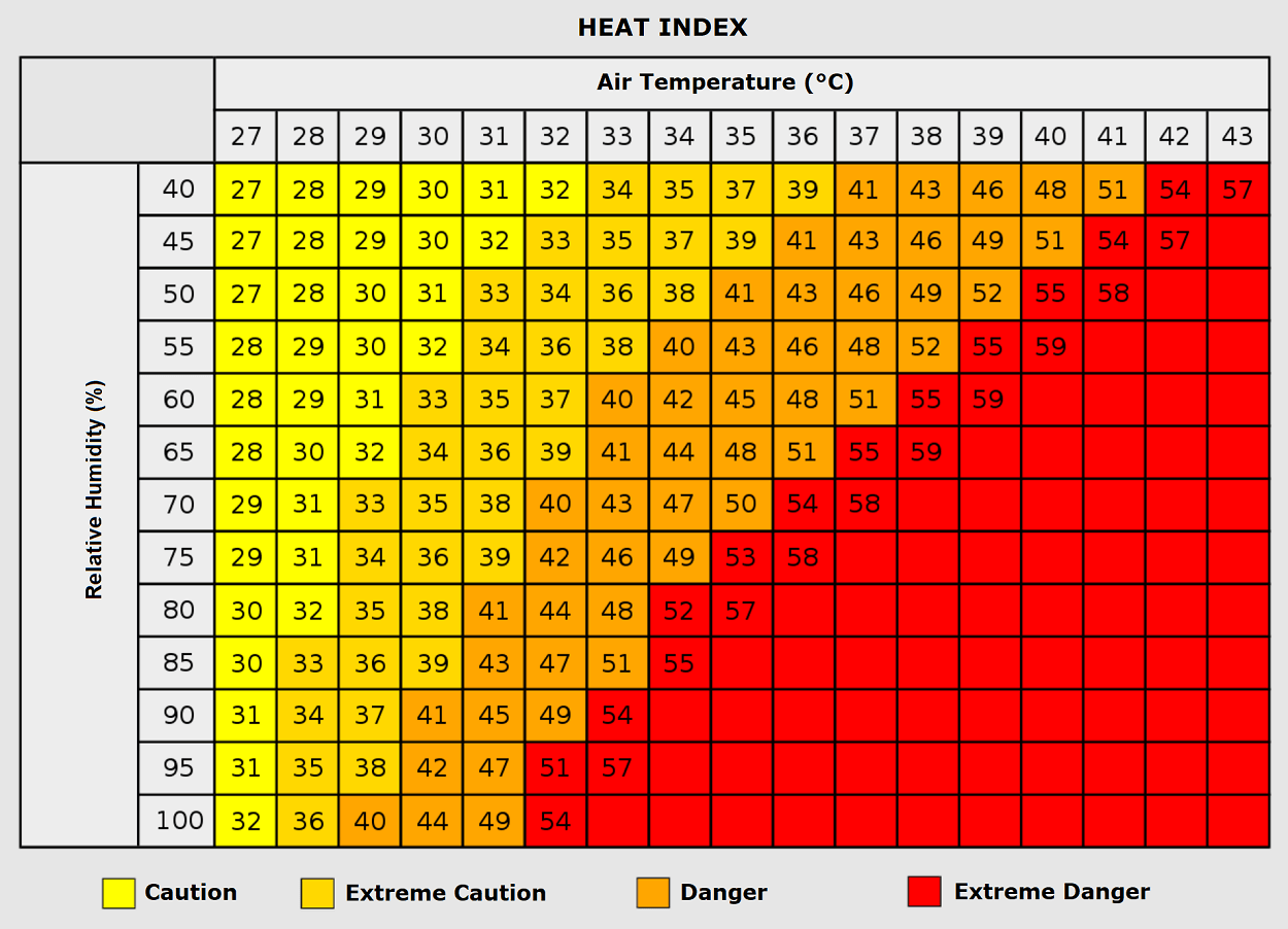
Public health officials have issued warnings regarding heat exhaustion and heat stroke. The "Heat Index" is a critical tool during this period, as it accounts for the synergy between air temperature and humidity. In regions like the Po Valley, where humidity may be higher, a temperature of 35°C can feel like 50°C to the human body, drastically increasing the risk of cardiovascular incidents and respiratory failure.
Economic and Infrastructure Implications
Beyond the immediate human health risks, the heatwave poses a challenge to infrastructure.
- Energy Grid Demand: With temperatures soaring, the demand for air conditioning and cooling systems is expected to peak. Grid operators in Italy, France, and Spain are operating under high-load conditions, monitoring for potential strain on power infrastructure.
- Agriculture: The agricultural sector is facing significant stress. The combination of early-September heat and prolonged drought conditions threatens late-season crops. Farmers in the Mediterranean region are reporting increased water usage for irrigation, further depleting already low water tables.
- Wildfire Risk: The combination of dry continental winds, high temperatures, and parched vegetation has elevated the wildfire danger index to extreme levels. Mountain slopes and forested regions in Southern Europe are currently under high alert for ignition risks.
Scientific Perspectives and Future Trends
The occurrence of such a powerful heat dome in early September serves as a focal point for discussions regarding atmospheric volatility. While high-pressure systems are a natural component of European weather, the intensity and duration of these "blocking" events have become a subject of intense scrutiny by climatologists.
The "omega block"—a specific atmospheric configuration that causes high-pressure systems to stall—has been a recurring feature of recent European summers. This configuration acts as a barrier, preventing the jet stream from flushing out stagnant air masses. As the climate shifts, the frequency and severity of these blocking events appear to be changing, leading to longer-lasting heatwaves that penetrate deeper into the shoulder seasons.
Looking Ahead: The Expected "Pattern Flip"
As the continent endures the current heat, the meteorological community is already looking toward the expected transition next week. The breakdown of the heat dome will likely be driven by an upper-level trough moving in from the North Atlantic.
This change is expected to be relatively abrupt, potentially bringing not just relief from the heat, but also the risk of localized severe weather. As the cooler, maritime air mass clashes with the residual heat trapped over the continent, the potential for thunderstorms—some potentially severe—increases.
For now, however, the focus remains on the short term. With several days of extreme heat still ahead, residents in affected areas are urged to stay hydrated, minimize outdoor activities during peak sunlight hours, and monitor local government guidance for cooling centers and heat-health advisories.
This late-summer heatwave is a poignant reminder of the power of atmospheric dynamics. As the ridge holds firm, Europe remains under the "lid," waiting for the inevitable shift in the winds that will finally bring the long-awaited autumn chill. Stay tuned to regional meteorological services for real-time updates as this event continues to unfold.