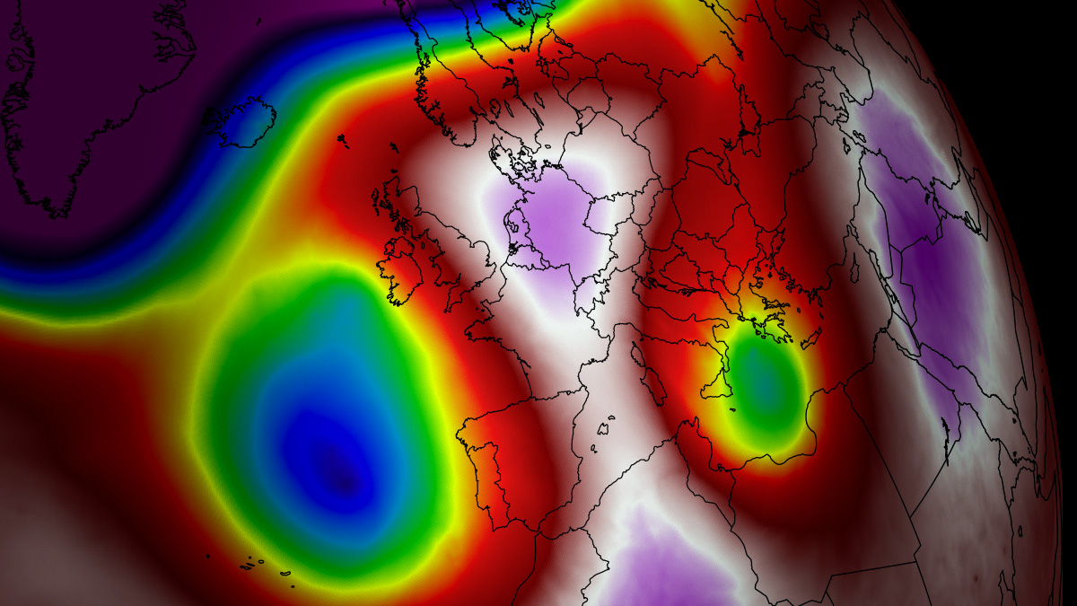
As the calendar turns to mid-August 2026, the European continent finds itself locked in the grip of its fifth major heatwave of the season. A high-amplitude, upper-level atmospheric ridge has parked itself over the heart of the continent, creating a formidable "Heat Dome" that is pushing mercury levels to dangerous, record-challenging heights. With thermal anomalies climbing into the 99th percentile, meteorologists are warning of an unprecedented meteorological event that threatens human health, energy infrastructure, and environmental stability across France, the United Kingdom, Italy, Central Europe, and the Balkan Peninsula.
The Atmospheric Engine: Anatomy of a Heat Dome
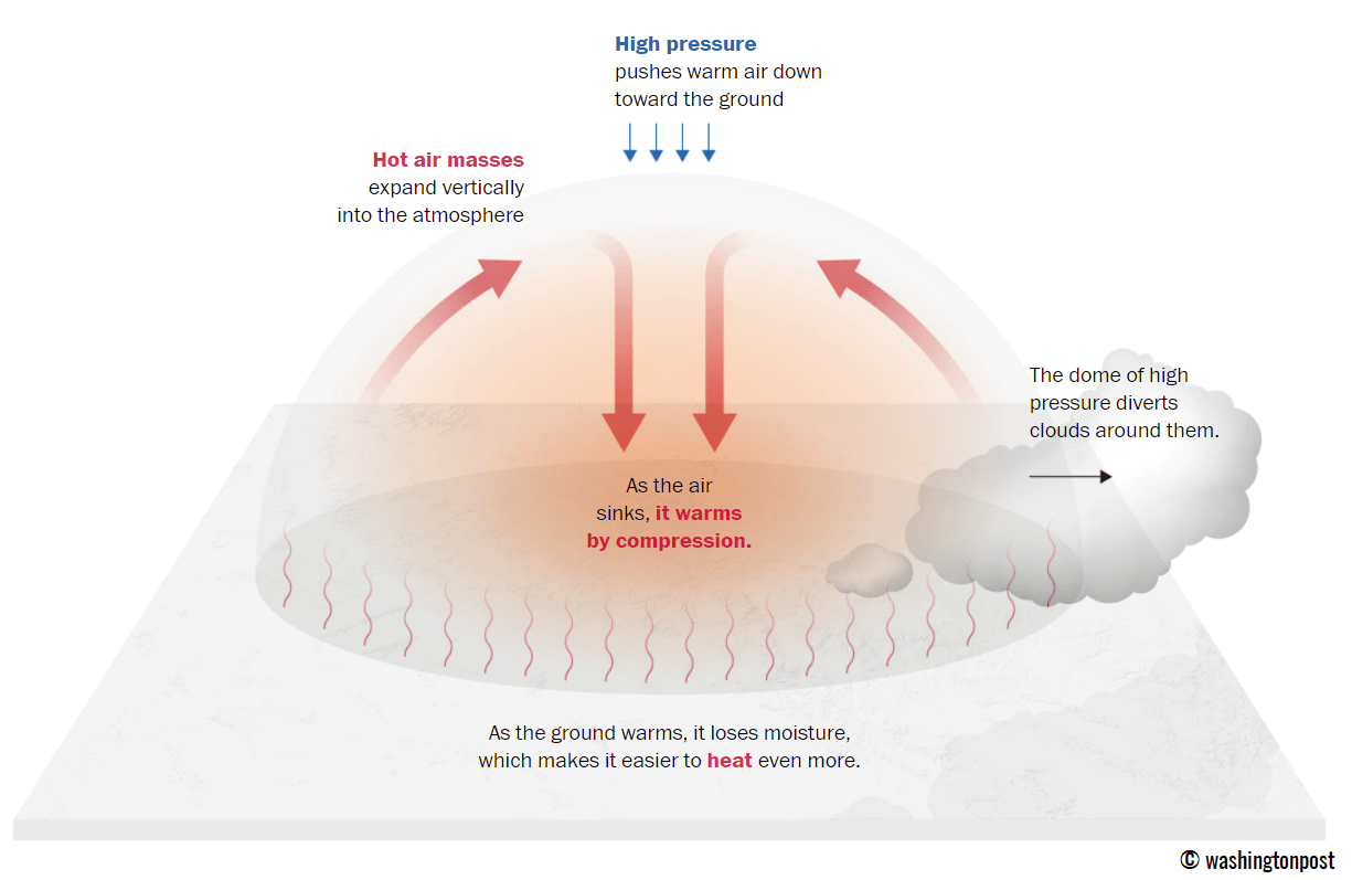
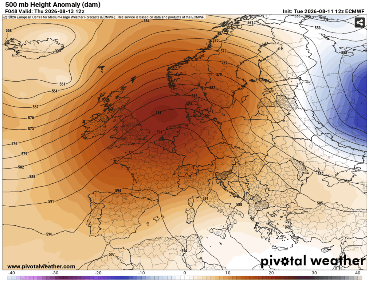
The phenomenon currently unfolding is not merely a warm spell; it is a textbook example of a persistent, high-pressure blocking pattern. At its core, this "Heat Dome" functions much like a lid on a boiling pot. A massive, stationary area of high pressure sits in the upper troposphere, acting as a barrier that prevents cooler, maritime air from circulating into the region.

As this high-pressure system dominates, it forces air to descend. As the air sinks, it undergoes adiabatic compression—a process where the pressure increases and, consequently, the temperature rises significantly. This trapped, descending air mass effectively "bakes" the surface below. Because the ridge is exceptionally stable, it has created a self-reinforcing loop: the ground dries out, vegetation withers, and the lack of moisture allows the sun to heat the earth even more efficiently, leading to surface temperatures that are projected to reach between 40°C and 43°C in low-lying basins and plains.
Chronology of the Thermal Surge
The current heat event is characterized by a dynamic, eastward-shifting core.
Early to Mid-Week (Wednesday–Friday):
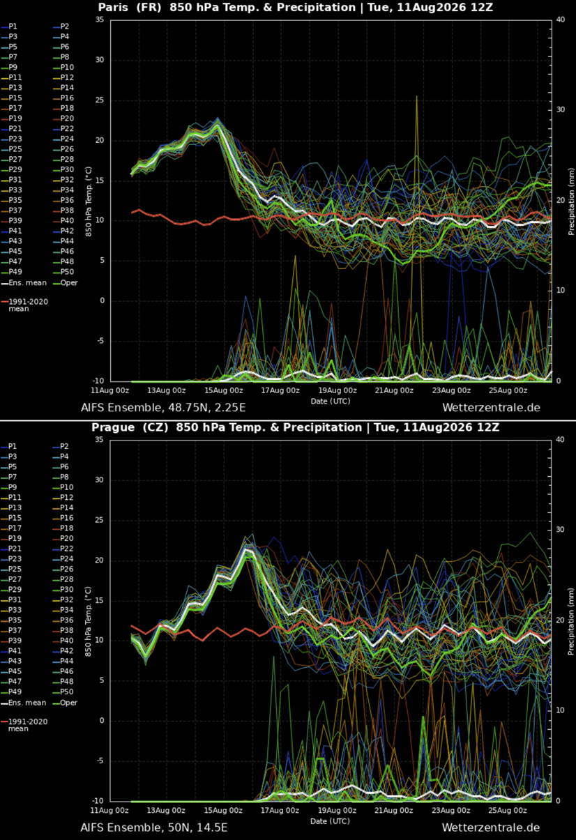
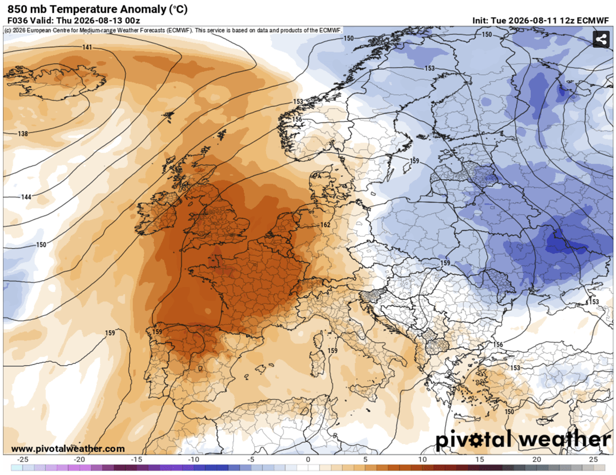
The initial phase of this fifth thermal wave has focused its intensity on Western Europe. By Wednesday, the heat dome began its consolidation, bringing sweltering conditions to the Iberian Peninsula, France, and Southern England. Thursday represents the peak of the heat for Western Europe, with the most extreme anomalies hovering over Northern France and the English Channel.
The Weekend Transition (Saturday–Sunday):
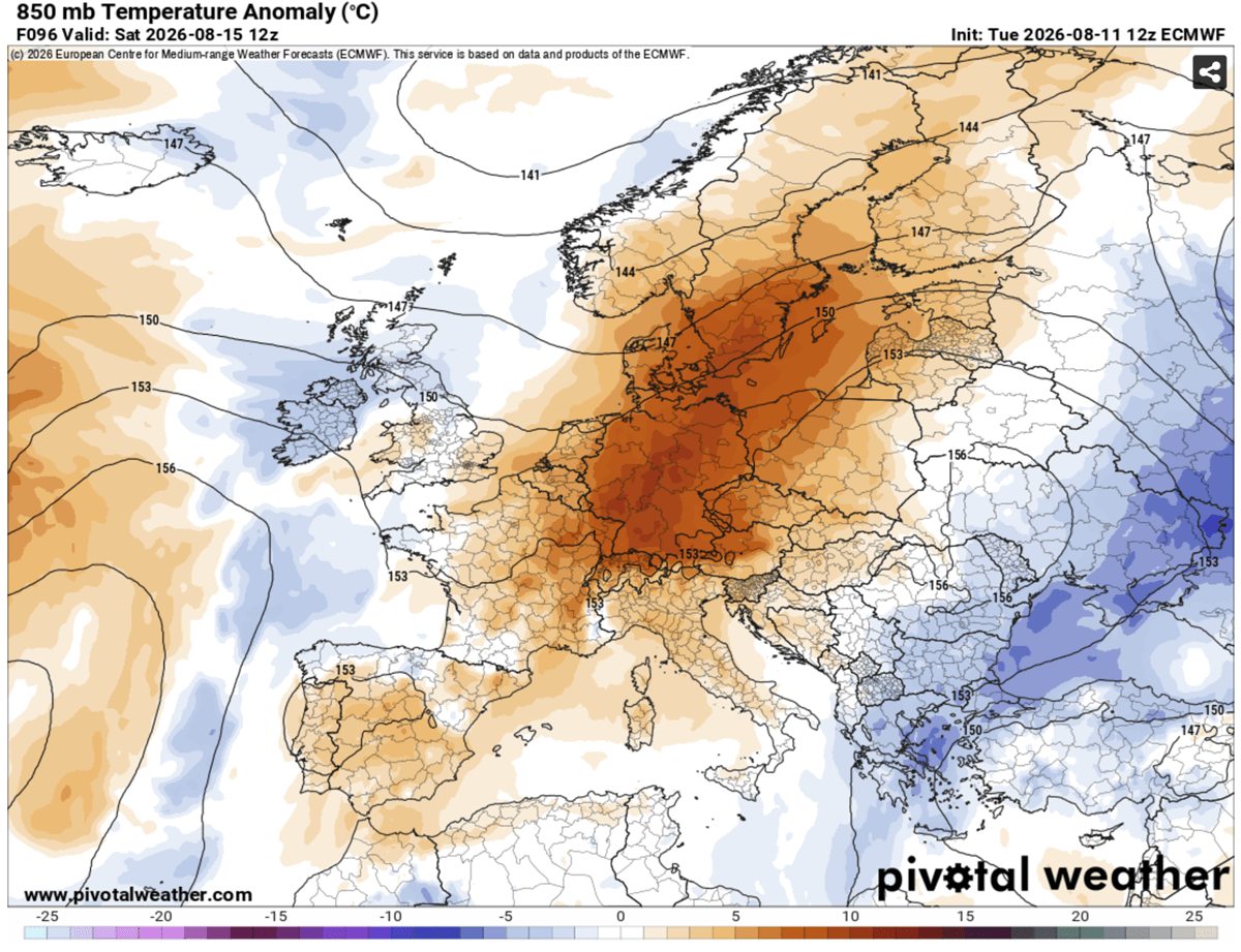
As the upper-level wave over the North Atlantic begins to push into Western Europe, the heat dome will be forced to evolve. Rather than dissipating immediately, it is expected to become more elongated, shifting its center of gravity toward Central Europe. By Saturday and Sunday, the focus of the extreme heat will migrate into Germany, the Czech Republic, Poland, the Alpine regions, Italy, and the Northern Balkans. While some relief is expected in the west as maritime air finally breaks through, these central and eastern regions will face a secondary, intense surge in temperatures.
Regional Breakdown of Temperature Extremes
The geographical reach of this event is expansive, with each region facing unique challenges:
- United Kingdom and Ireland: While typically accustomed to more temperate conditions, England is bracing for a short but fierce spike. Temperatures are expected to peak between 38°C and 39°C on Thursday. Even Ireland, usually buffered by the Atlantic, will see temperatures rising, with the southern and central regions nearing the 30°C mark.
- France and the Benelux: France remains at the epicenter of the heat. Forecast models consistently point toward temperatures reaching 42–43°C in the western and central provinces. By Friday, the heat will have reached its zenith in Belgium, Luxembourg, and the southern Netherlands, with highs expected to sit between 36°C and 40°C.
- The Iberian Peninsula: Portugal and Spain are seeing the most persistent heat. With valleys in southern Spain expected to hit 42–44°C, the region is facing critical fire weather conditions. Portugal’s inland regions will see sustained temperatures of 37–40°C, further stressing already depleted water reserves.
- Italy and the Balkans: As the weekend approaches, the Pannonian Plains and the Po Valley will become the new hotspots. With humidity remaining a factor, "feels-like" temperatures in these regions could climb well toward the 45°C threshold, creating significant physiological danger for the local population.
The Hidden Danger: Tropical Nights and Physiological Stress
Perhaps the most insidious aspect of this fifth heat dome is the lack of nocturnal recovery. In meteorological terms, this is referred to as "tropical nights," where the minimum temperature fails to drop below 22°C to 26°C.
For the human body, the overnight period is essential for recovery. When temperatures remain high during the night, the body is denied the opportunity to shed the heat accumulated during the day. This leads to cumulative physiological stress, particularly for the elderly, those with chronic respiratory or cardiovascular conditions, and urban residents living in "heat islands"—areas dominated by concrete and asphalt that absorb and re-radiate heat long after the sun has set.
Implications for Society and Infrastructure
The cascading effects of such an intense and prolonged heatwave are profound:
1. Energy Grid Strain
As millions of residents and businesses turn to air conditioning to survive, electricity demand is hitting record levels. This places immense strain on national power grids, increasing the risk of rolling blackouts or localized failures. The necessity of maintaining cooling for critical infrastructure, such as hospitals and data centers, further complicates the burden on energy providers.
2. Public Health Crisis
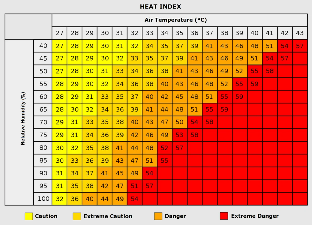
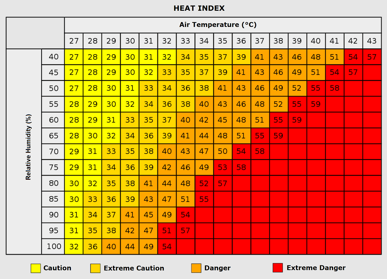
Health authorities are already reporting an uptick in heat-related illnesses, ranging from heat exhaustion to severe heat stroke. The combination of high ambient temperatures and high humidity—the "Heat Index"—is the most dangerous factor. When humidity levels are high, the body’s primary cooling mechanism, sweat evaporation, becomes ineffective. This leads to rapid core temperature spikes that can be fatal if not treated immediately.
3. Agricultural and Wildfire Risk
The combination of high heat and low soil moisture creates a tinderbox environment. Across Southwestern and Central Europe, the risk of forest fires is at an all-time high. Agricultural sectors are also under duress; crops such as maize and grapes, which are critical to the European economy, are suffering from heat stress, potentially leading to reduced yields and increased food prices later in the year.
Official Responses and Preparedness
Governments across the affected regions have initiated "Red" or "Orange" heat alerts. In France, the Plan Canicule (Heatwave Plan) has been activated, emphasizing the protection of vulnerable citizens through community outreach and the opening of "cool rooms" in municipal buildings.
In the UK, public health agencies have issued urgent guidance for outdoor workers, recommending the rescheduling of strenuous labor to the early morning or evening hours. Meanwhile, in Italy and the Balkans, authorities are closely monitoring water usage, as drought conditions exacerbated by the heat have led to mandatory restrictions in several districts.
Looking Ahead: A Pattern Flip?
While the current outlook remains grim through the weekend, meteorological models are beginning to show signs of a "pattern flip" for the following week. A major shift in the North Atlantic jet stream may finally break the blocking high-pressure system, allowing for a more dynamic and cooler westerly flow to reach the continent.
However, until that shift occurs, the message from meteorologists is clear: the current Heat Dome is a high-impact, life-threatening event. Residents are urged to minimize physical exertion, stay hydrated, and check on elderly neighbors. As Europe navigates this fifth major thermal event of 2026, the necessity of long-term climate adaptation strategies is becoming an unavoidable reality for policymakers and the public alike.
This report was synthesized using data from top-tier meteorological models, including high-resolution imagery provided by PivotalWeather and WXcharts. We will continue to monitor the evolution of this heat dome as it moves across the continent.