By Mika Rantanen
Published August 10, 2026
For many Finns, the summer of 2026 has felt curiously understated. While recent years have conditioned the public to anticipate aggressive, record-breaking heatwaves, this year has offered a different narrative—one defined by variability, refreshing interludes, and a return to long-term climatological averages. As we cross into the second week of August, meteorological data confirms that the fervor of the sun has been uncharacteristically muted, marking this season as the least "hot" in nearly a decade.
The State of the Season: A Return to the Norm
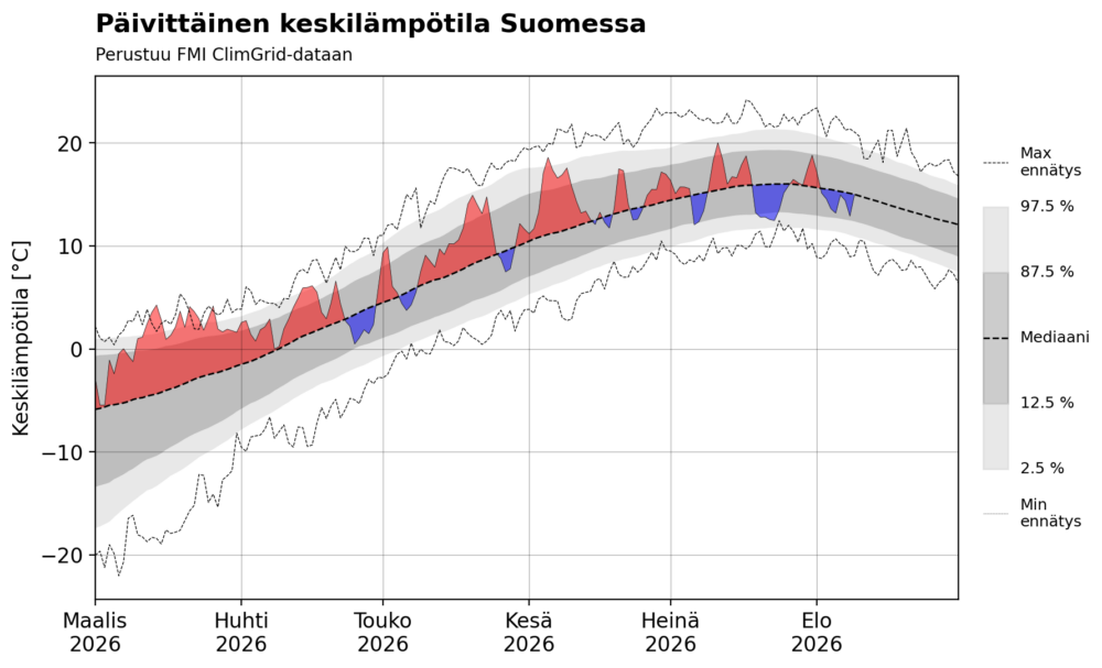
When looking back at the progression of the year, it is evident that the early enthusiasm of spring was deceptive. Following a season of sustained, above-average warmth, the weather patterns shifted abruptly after the beginning of June. Since then, the atmosphere over Finland has been characterized by a restless, rapid succession of air masses rather than the stagnant, high-pressure "blocking" patterns that typically usher in prolonged summer heat.
Contrary to the anecdotal perception that the summer has been "cold," data analysis reveals a more nuanced reality. The overall mean temperature for the summer to date is remarkably close to the long-term average. While the lack of extreme, weeks-long heatwaves has created a psychological sense of chill, the statistics show that the climate has merely been correcting itself toward its historical baseline.
The most notable departure from this "normal" occurred in mid-July. On July 23, the national average temperature plummeted to a mere 12.5 degrees Celsius, a figure that sat perilously close to historical cold records for that specific date. However, these excursions into the cold have been mirrored by the lack of extreme warmth; since March 2026, there have been no significant national temperature records shattered, suggesting a summer that has lacked both the highest peaks and the lowest valleys.
Chronology of the Heat: Defining the "Hot Day"
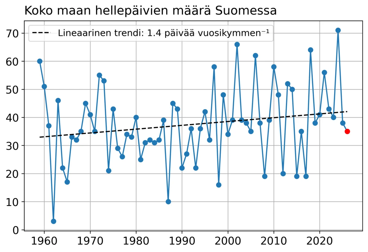
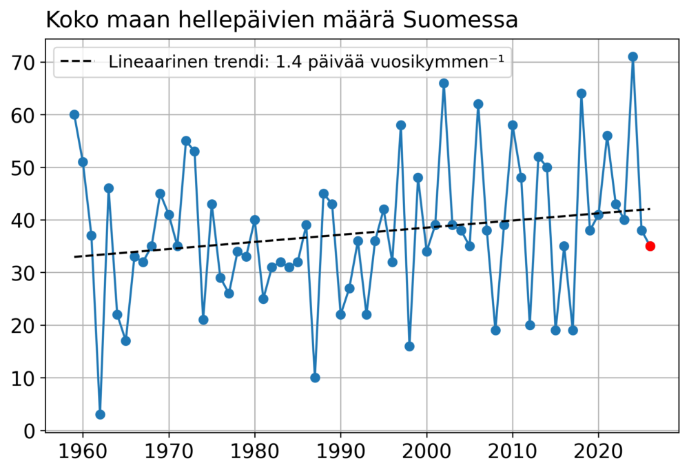
One of the most reliable metrics for assessing the intensity of a Nordic summer is the number of "hot days"—days where the maximum temperature reaches at least 25.1 degrees Celsius. As of August 10, 2026, the national count stands at 35.
A technical discrepancy exists between this figure and the official statistics provided by the Finnish Meteorological Institute (FMI), which lists 34 days. This difference arises from a measurement taken in Porvoo Harabacka on June 22. In meteorological record-keeping, the official "daily maximum" is calculated between 18:00 and 18:00 UTC. Because the heat peak at Harabacka was recorded shortly after the 18:00 cutoff on June 21, it was logged as part of the following day’s data. Furthermore, official heat-day statistics are based on the maximum temperature measured during the "daytime" window (06:00–18:00 UTC). This rigorous adherence to temporal protocols highlights the complexity of climate data management, where slight variations in timing can impact the historical record.
Regardless of the one-day discrepancy, the trajectory is clear: with only a few weeks remaining, 2026 is on track to record the lowest number of hot days since 2017. When compared to the 30-year median of 39 days, the current count is slightly below average. This is a significant statistical milestone, as it breaks a nine-year period characterized by increasingly frequent and intense heatwaves, underscoring a temporary pause in a long-term upward trend.
Supporting Data: The Impact of Atmospheric Circulation
To understand why Finland has been spared the extreme heat, one must look at the larger atmospheric picture. The primary drivers of surface temperature are the positioning of high and low-pressure systems and the resulting steering of air masses.
Throughout this summer, a persistent, "locked" atmospheric pattern has dominated the European continent. A high-pressure system—often referred to in meteorology as a "heat dome"—has repeatedly anchored itself over Western Europe and the British Isles. This phenomenon has created a feedback loop, forcing hot air to settle and intensify over the same regions, leading to repeated, punishing heatwaves for countries like France, Spain, and parts of Germany.
Finland and the Fennoscandian region, however, have largely remained on the periphery of these high-pressure blocks. While warm pulses have occasionally pushed north, they have been fleeting and significantly weakened by the time they reached our latitudes. The atmospheric "gatekeepers"—the jet stream and the positioning of planetary waves—have effectively acted as a shield, preventing the prolonged heat stagnation that has plagued the rest of the continent.
Global Drivers: The Shadow of El Niño
The persistence of this atmospheric configuration has led researchers to look beyond regional weather patterns and consider large-scale "drivers" that influence the climate on a monthly or seasonal scale. The most prominent suspect in the 2026 climate puzzle is a powerful, record-breaking El Niño event.
El Niño, characterized by the warming of ocean surface temperatures in the central and eastern Pacific, has profound effects on the global atmosphere, altering jet stream patterns and regional weather for months. Historical data suggests a strong correlation between El Niño years and specific temperature anomalies in Europe: Western and Central Europe tend to experience intensified heat, while Finland and Eastern Europe often find themselves in the path of cooler, more unstable, and more variable weather systems.
The 2026 summer alignment fits this historical template with remarkable precision. While it is impossible to attribute a single season’s weather to one solitary factor, the magnitude of this year’s El Niño suggests it has played a central, foundational role in the regional disparities seen across Europe. By shifting the "blocking" highs to the west, El Niño has essentially rewritten the rulebook for this year’s European summer. Future research will undoubtedly delve into the specific mechanics of how this year’s oceanic warming facilitated the unique atmospheric locking observed across the continent.
Implications for the Future of Finnish Summers
As we head toward the end of August, the outlook remains stable. Weekly forecasts suggest that while there may be minor pulses of warmth that register as individual hot days, there is no evidence of a major, sustained heatwave on the horizon. The final tally for the summer of 2026 will likely settle between 35 and 40 hot days, bringing us back into alignment with long-term historical averages.
This season serves as a critical case study in climate variability. It reminds us that even within a broader, long-term trend of warming, the climate is not a linear progression. Regional weather remains subject to the chaotic, complex interactions of atmospheric and oceanic systems.
For the citizens of Finland, this has been a summer of reprieve—a reminder of the "classic" Nordic summer that many feared was becoming a relic of the past. However, the data also serves as a warning: the same mechanisms that steered the heat away from us this year have the potential to deliver even more extreme conditions in the future. As we continue to monitor the long-term impact of global climate change, the 2026 season will stand as a testament to the fact that while our climate is changing, the unpredictable nature of the atmosphere ensures that each summer will continue to hold its own unique set of surprises.
The scientific community will spend the coming years deconstructing the 2026 weather data to better understand the interplay between the record-breaking El Niño and the persistent European heat domes. For now, we can appreciate the moderate temperatures that have allowed the forests to thrive, the reservoirs to remain replenished, and the Finnish summer to exist, for one more year, in a state of comfortable, temperate balance.