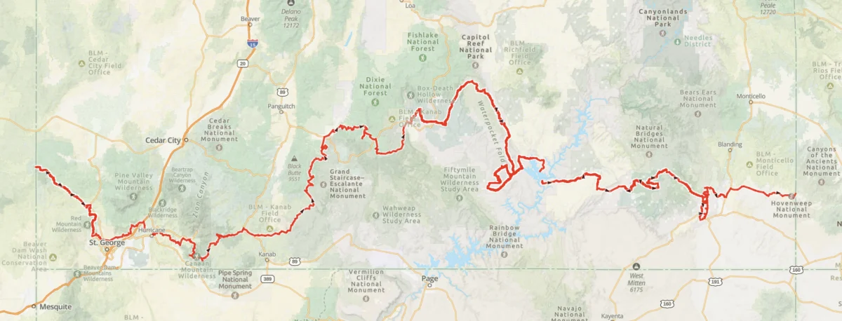
From late April to early June of this year, long-distance hikers Kate “Swept Away” Pickett and I undertook an ambitious, 800-mile (1,287 km) traverse across the rugged expanse of southern Utah. This journey, which spanned seven weeks, was not merely a test of physical endurance but an immersive expedition through some of the most geologically and archeologically significant terrain in the American West.

By linking canyons, plateaus, badlands, and mesas, our route represented a deep dive into the heart of the Colorado Plateau. While both Pickett and I have significant experience in this region—having previously completed the Hayduke Trail—this specific expedition was motivated by a desire to explore "blank spots" on our personal maps, including the remote corners of the Canaan Mountain Wilderness and the pristine, ancient landscapes within Bears Ears National Monument.

Main Facts: The Scope of the Expedition
The Southern Utah Traverse was designed to be more than a simple point-to-point hike; it was a deliberate investigation of the state’s complex topography. Starting at the Nevada border, southwest of Enterprise, and culminating at the Hovenweep National Monument on the Colorado border, the route demanded a high degree of navigational skill and logistical planning.

- Distance: Approximately 800 miles (1,287 km).
- Duration: Seven weeks (late April to early June).
- Geography: A mix of high-desert plateaus, deep slot canyons, expansive badlands, and sandstone mesas.
- Methodology: A combination of cross-country navigation, historical 4WD tracks, river wading, and established trail systems.
The decision-making process for the route was guided less by the fastest path and more by the pull of geological curiosity. Whether it was the soaring white domes of the Canaan Mountain Wilderness or the silent, wind-sculpted arches of the Escalante region, every mile was curated to maximize exposure to the unique, vibrant history of the landscape.

A Chronological Overview
The journey was divided into eight distinct stages, with each segment defined by necessary resupply points. This structure allowed for a tactical approach to water management and food rationing in one of the most arid environments on the planet.

Stage 1: The Western Gateways
We began in the high desert near the Nevada border. This early phase focused on the transition from the Great Basin into the distinct red rock country of southwestern Utah. A highlight of this stretch was the Canaan Mountain Wilderness, a place of profound solitude and verticality. Navigating the "White Domes" and witnessing the wind-carved "Eye of Heaven" (Water Canyon Arch) set the tone for the architectural grandeur we would experience for the remainder of the trip.

Stage 2: Canyons and High Plateaus
As we progressed toward the central corridor of the state, the terrain shifted from arid scrubland to the iconic slot canyons for which Utah is famous. Passing through Bryce Canyon, we experienced the dramatic contrast between the high-elevation forests and the eroded amphitheaters that define the park. The "Barracks" served as a grueling but rewarding water-based test of endurance, requiring significant wading through technical canyon sections.

Stage 3: The Heart of the Monument
Entering the Grand Staircase-Escalante National Monument, the pace slowed. The environment here is a complex, folded landscape of sandstone that requires constant route-finding. We spent time in Death Hollow, enjoying the sandy bench campsites that offer a rare, shaded respite in the desert heat. The journey through this sector was punctuated by the awe-inspiring sight of Jacob Hamblin Arch in Coyote Gulch.

Stage 4: The Eastern Frontier and Bears Ears
The final major push brought us into the Bears Ears National Monument. While both of us had previously traversed the northern sections of this area, the southern reaches—specifically Cedar Mesa, Grand Gulch, and the storied Comb Ridge—offered a transformative experience. Exploring the “Perfect Kiva” in Bullet Canyon and the Procession Panel at Comb Ridge provided a sobering, profound connection to the ancestral cultures that once thrived in these canyons.

Supporting Data: The Logistics of Survival
In the desert, information is as vital as oxygen. Planning for the Southern Utah Traverse required a sophisticated approach to data, particularly regarding the two most critical variables: water and supplies.

Water Resource Management
Water security was the primary planning constraint. We relied on a combination of USGS topographic data and the specialized hydrology resources provided by the Across Utah project.

Because we were traveling in the shoulder season, water sources were often ephemeral. Our strategy involved:

- Capacity Planning: Carrying a maximum of 9-10 liters when traversing the most remote, dry sections.
- Meteorological Leveraging: Utilizing localized storm events to recharge potholes and streams.
- Cautious Redundancy: In areas without verified recent reports, we operated on the assumption that a source would be dry, erring on the side of carrying excess weight to ensure safety.
Resupply Strategy
To maintain a 1,287 km traverse, we utilized a hybrid model:

- Mail Drops: Essential for remote locations like Escalante and Kanab, where we relied on friends and family to hold supplies.
- On-the-Go Purchasing: Used in towns with accessible grocery infrastructure.
- Cache Deployment: We strategically placed a cache at Burr Trail Road to bridge the significant distance between the town of Escalante and the Bullfrog Marina, ensuring we did not run out of fuel or calories in the desolate middle stages.
Official Requirements and Compliance
Navigating federal lands in Utah requires strict adherence to permit systems, which vary by jurisdiction. We managed a complex web of requirements:

- America the Beautiful Pass: The foundation of our access to the National Park system.
- Specific Permits: We secured backcountry overnight permits for Bryce Canyon, Grand Staircase-Escalante, Capitol Reef, and the specific protected regions within Bears Ears.
- Interagency Cooperation: The Escalante Interagency Visitor Center was instrumental in providing up-to-date, on-the-ground information for the Grand Staircase and Capitol Reef portions of our trek.
Implications: The Future of Remote Trekking
The success of the Southern Utah Traverse highlights the enduring appeal of the American backcountry, but it also underscores the growing responsibility placed upon hikers. As these routes become better documented, the balance between sharing knowledge and protecting fragile ecosystems becomes increasingly delicate.

Cultural and Environmental Sensitivity
The presence of archaeological sites like those found in Bears Ears and the Grand Gulch necessitates a "leave no trace" ethos that goes beyond basic trash removal. We approached these areas with extreme caution, ensuring that our travel paths did not impact cryptobiotic soils or disturb delicate, ancient structures. The "Perfect Kiva" and the petroglyphs at the Procession Panel are not just sights; they are cultural heritage sites that require quiet, respectful visitation.

The Value of "Slow Travel"
The decision to prioritize curiosity over expediency meant that we frequently detoured to explore side canyons or hidden alcoves. This "slow travel" approach allowed for a deeper understanding of the landscape’s rhythm. It serves as a reminder that the most rewarding aspects of long-distance hiking are rarely found on the fastest route, but in the moments of discovery that occur when a hiker decides to stop, observe, and engage with the environment.

A Call for Preparedness
The Southern Utah Traverse is not a beginner’s route. The physical demands of the terrain, combined with the extreme heat, the requirement for technical navigation, and the isolation, make it a challenge that demands significant experience. As interest in these types of remote, off-trail treks grows, it is imperative that future explorers prioritize self-sufficiency and deep preparation over social media aesthetics.

In conclusion, the journey across southern Utah was a testament to the power of the wilderness to challenge, humble, and inspire. By walking through the red rock labyrinth, we didn’t just see the landscape—we became part of its long, storied history. The maps and resources we have compiled from this trip will serve as a guide for others, but the true value lies in the silent, sun-drenched lessons learned in the depths of the canyons, where the only sound is the wind, and the only guide is the path you carve for yourself.