Issued by Severe Weather Europe | September 9, 2026
Forecaster: Marko Korosec
A volatile and dangerous meteorological pattern is unfolding across the European continent, prompting meteorologists to issue urgent warnings for a multi-day severe weather outbreak. Spanning from the Balearic Islands to the Balkan Peninsula, this high-impact event is expected to bring a cocktail of life-threatening phenomena, including giant hail, destructive winds, tornadoes, and catastrophic flash flooding.
The meteorological instability, fueled by a historic marine heatwave across the Mediterranean, has created an environment primed for explosive convective development. Authorities are urging residents and travelers in affected regions to remain vigilant as the storm system moves across the continent through Friday afternoon.
The Meteorological Drivers: A Perfect Storm
The current severe weather outlook is dictated by the arrival of a deep, potent upper-level trough pushing into Western Europe. As this system moves eastward, it is interacting with a decaying high-pressure ridge that previously dominated Eastern Europe.
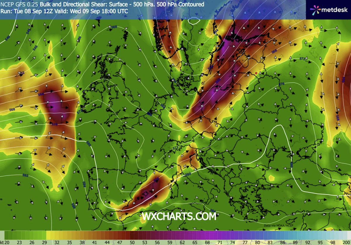
The collision of these large-scale atmospheric features has resulted in a powerful southwesterly jet stream. This jet is acting as a catalyst, providing intense wind shear—the change in wind speed and direction with height—which is critical for the development of rotating supercell thunderstorms.
Underneath this dynamic environment lies a moisture-laden air mass. Because the Mediterranean Sea has experienced a prolonged and historic marine heatwave this season, the lower atmosphere is saturated with extreme levels of humidity. Dewpoints are currently hovering near or exceeding 25°C, providing the necessary "fuel" for the thunderstorms. When this moisture meets the mechanical lifting provided by the incoming cold front, the result is an atmosphere with extreme Convective Available Potential Energy (CAPE), estimated between 3,000 and 4,000+ J/kg.
Chronology of the Outbreak
Wednesday, September 9: The Initial Surge
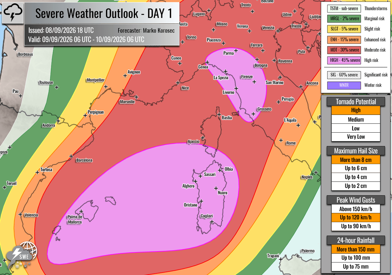
The outbreak commences in earnest on Wednesday morning. The primary focus for the most intense activity is the Balearic Islands, southern Corsica, Sardinia, and the Italian regions of Tuscany and Liguria.
- Morning to Afternoon: Explosive storm initiation is expected over the Balearic Islands and the Ligurian Bay. The combination of extreme CAPE and intense low-level shear creates an environment conducive to isolated, yet highly destructive supercells.
- Evening Progression: As the system shifts east-northeast, these individual cells are expected to merge into larger convective clusters. The primary threats during this phase include very large to giant hail—potentially reaching 6–10 cm in diameter—and damaging winds. The coastal regions of Liguria and Tuscany are under particular scrutiny for tornadic activity, as southerly winds interacting with the local topography increase the risk of rotation within storms.
- Overnight: The storm clusters will continue their trek across northern Italy, eventually encroaching upon western Slovenia and northwestern Croatia. Residents in these areas should prepare for sudden, violent shifts in weather conditions during the late evening hours.
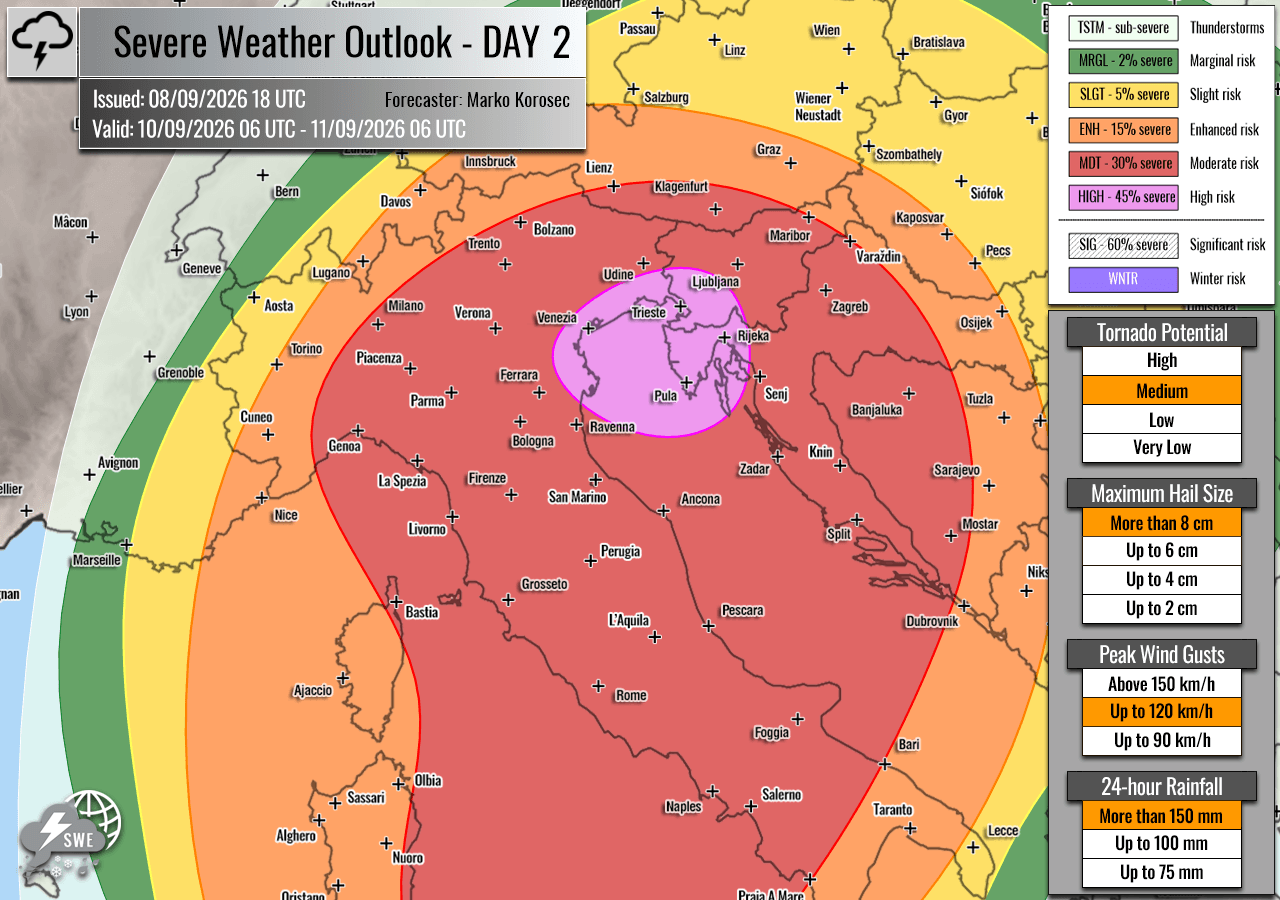
Thursday, September 10: The Adriatic Peak
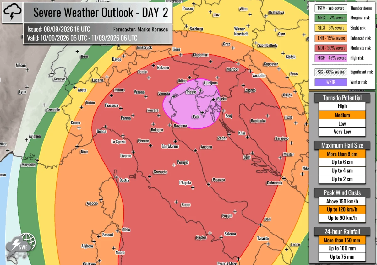
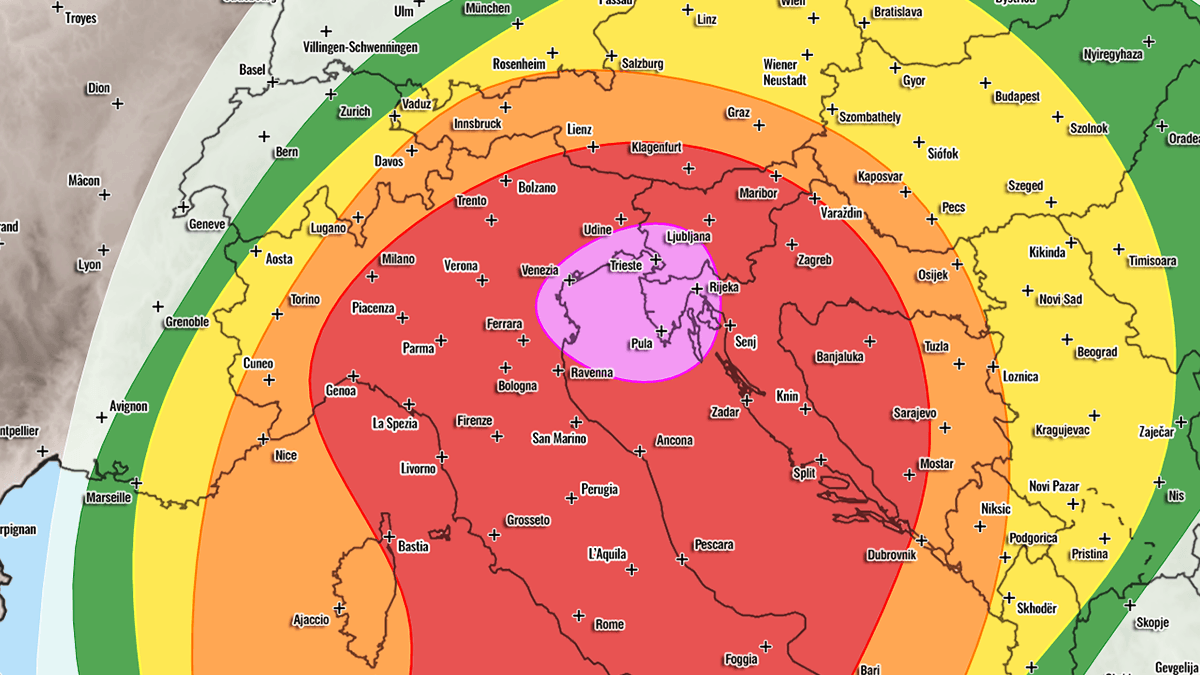
As the cold front pushes deeper into the Balkan Peninsula and the Adriatic basin, the focus of the "HIGH" risk shifts eastward.
- Daytime Activity: The northern Adriatic Sea, northeastern Italy, western Slovenia, and northwestern Croatia are designated as the highest-risk zones for Thursday. The environment remains primed with persistent moisture transport from the Adriatic Sea, which serves to maintain extreme instability.
- Storm Mode: While early Thursday may see discrete supercells, the afternoon is expected to transition into a period of massive, slow-moving multicell storms. These systems are notorious for "training"—where multiple storms pass over the same geographical location in succession—leading to staggering rainfall totals.
- Flash Flood Potential: Given the region’s recent struggle with severe drought, the ground is hard and potentially hydrophobic, increasing the risk of rapid runoff. With some areas predicted to receive 200–300 mm of rain within a 36-hour window, destructive flash flooding is a near-certainty in vulnerable areas.
Supporting Data: Understanding the Threat Metrics
Meteorological modeling, supported by data from platforms such as PivotalWeather, consistently indicates an anomalous environment. The following variables highlight why this event is classified as "significant":
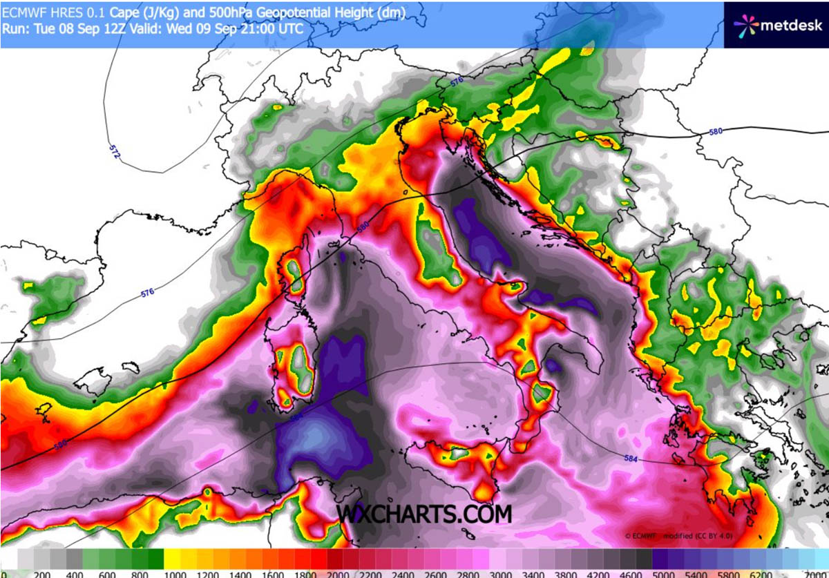
- Extreme Instability (CAPE): Readings of 3000–4000+ J/kg are rarely seen in this latitude at this time of year. This represents a massive reservoir of energy waiting to be released as kinetic energy in the form of updrafts.
- Wind Shear Profiles: The intensity of the mid-level jet stream ensures that storms will not remain static. The shear allows storms to become "organized," meaning they can sustain themselves for hours rather than dissipating quickly, as is common with "pop-up" summer storms.
- Low-Level Helicity: The presence of strong southeast low-level flow in the Mediterranean creates high storm-relative helicity. This is the "secret sauce" for tornado formation, as it creates a spinning motion in the atmosphere that updrafts can tilt into vertical rotation.
Implications and Public Safety
The implications of this weather event are severe. The combination of giant hail and high winds poses a significant threat to infrastructure, agriculture, and public safety.
Infrastructure and Urban Areas
In urban centers along the Italian and Croatian coasts, flash flooding poses a threat to subterranean infrastructure, including metro systems, parking garages, and low-lying residential areas. Heavy rainfall on parched, drought-stricken soil is likely to trigger mudslides, particularly in the mountainous regions of the Alps and the Apennines.
Agriculture
The agricultural sector in northern Italy and the Adriatic regions is highly vulnerable. Giant hail is capable of destroying entire harvests in minutes, shattering greenhouses, and stripping orchards. Farmers are advised to secure equipment and, where possible, protect livestock from the immediate path of the storms.
Maritime Safety
The Mediterranean and Adriatic Seas will face hazardous conditions. Mariners should expect rapidly changing sea states, including high-frequency wave action and potential waterspouts. Small craft should remain in port, and larger vessels should monitor real-time meteorological updates, as the "High" risk designation implies a high probability of significant convective wind gusts capable of capsizing smaller watercraft.
Official Responses and Preparedness
While official government weather agencies are currently monitoring the situation, the "High" risk classification issued by Severe Weather Europe serves as a crucial signal for disaster management agencies.
Recommendations for the Public:
- Stay Informed: Monitor local meteorological services (such as Servizio Meteorologico in Italy or DHMZ in Croatia) for site-specific watches and warnings.
- Shelter Protocols: If a severe thunderstorm warning is issued, move to an interior room on the lowest floor of a sturdy building. Avoid windows.
- Avoid Flood Zones: Never attempt to drive or walk through flooded roadways. Just 30 cm of moving water can sweep a vehicle away.
- Secure Property: Move outdoor furniture, vehicles, and loose objects inside to prevent them from becoming projectiles in high-wind events.
- Tornado Readiness: If you hear a roar similar to a freight train or notice a funnel cloud, take immediate cover. Do not wait for a siren if you observe the danger directly.
As the system matures, the interaction between the cold front and the mountainous terrain of the Alps and Dinaric Alps will likely enhance rainfall intensity. The next 48 to 72 hours will be critical for the regions of Italy, Slovenia, and Croatia. This is not merely a standard weather event; it is a significant meteorological outbreak that requires the full attention of both local authorities and the general public.
Final Note: This forecast is based on current models as of September 9th. Atmospheric conditions can shift rapidly; therefore, all residents are strongly encouraged to check for updated advisories every few hours throughout the duration of the event.