Executive Summary: A Sharp Seasonal Shift
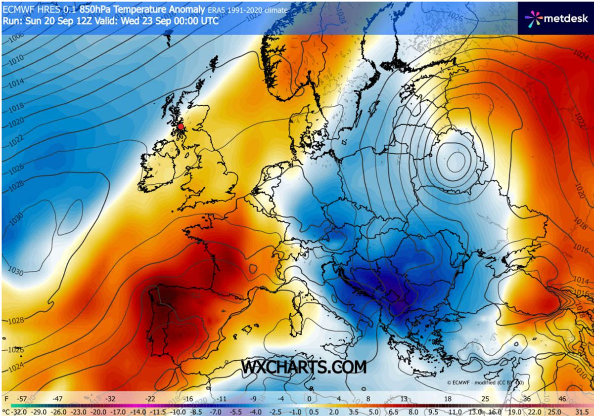
In a stark reversal of late-summer warmth, a massive upper-level blocking ridge over the North Atlantic and Scandinavia is currently orchestrating a profound meteorological shift across the European continent. This synoptic configuration has opened a direct atmospheric "corridor," channeling dense, polar-origin air deep into the heart of Eastern Europe.
The resulting thermal collapse is set to drop daytime high temperatures by 10 to 15°C below seasonal averages, marking a definitive end to the unseasonable warmth that has defined the early part of September 2026. As the polar front descends, meteorological agencies are tracking a significant transition that will bring the first taste of winter to the region, including potential snowfall at high altitudes and widespread morning frosts in agricultural basins.
The Synoptic Setup: Anatomy of a Polar Blast
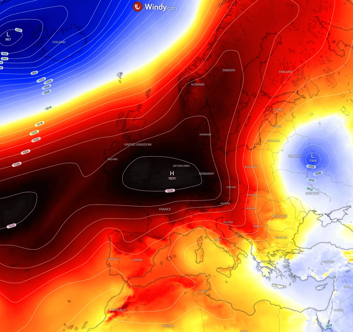
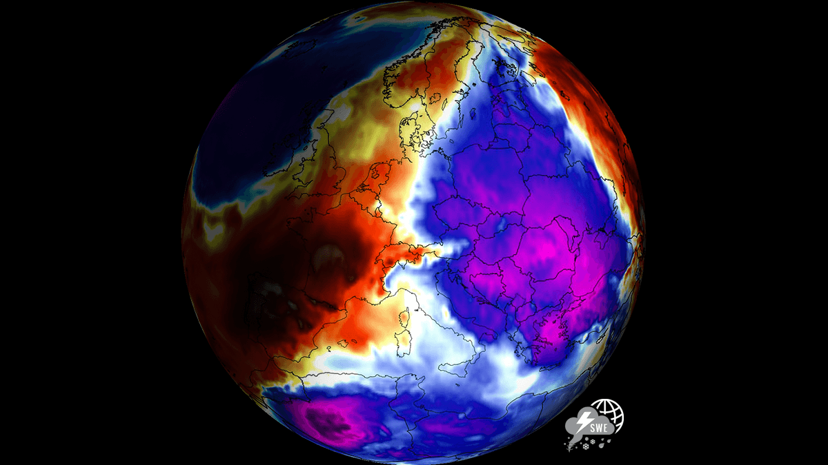
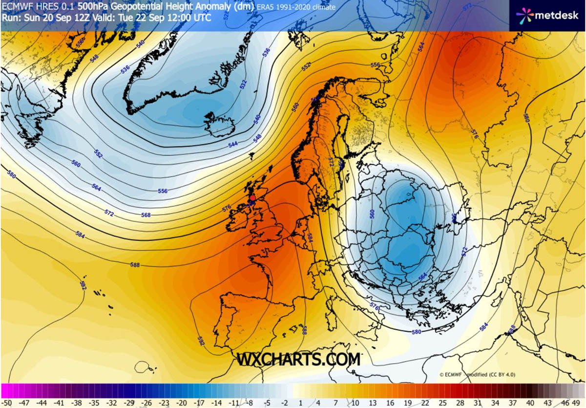
The mechanism driving this cold snap is a textbook example of meridional flow. At the center of the event is a robust, high-pressure blocking ridge positioned over the North Atlantic, which has effectively stalled the usual westerly flow of air. As this ridge extends toward Northern Europe and merges with a developing Scandinavian High, it forces the jet stream to buckle.
The Atmospheric Corridor
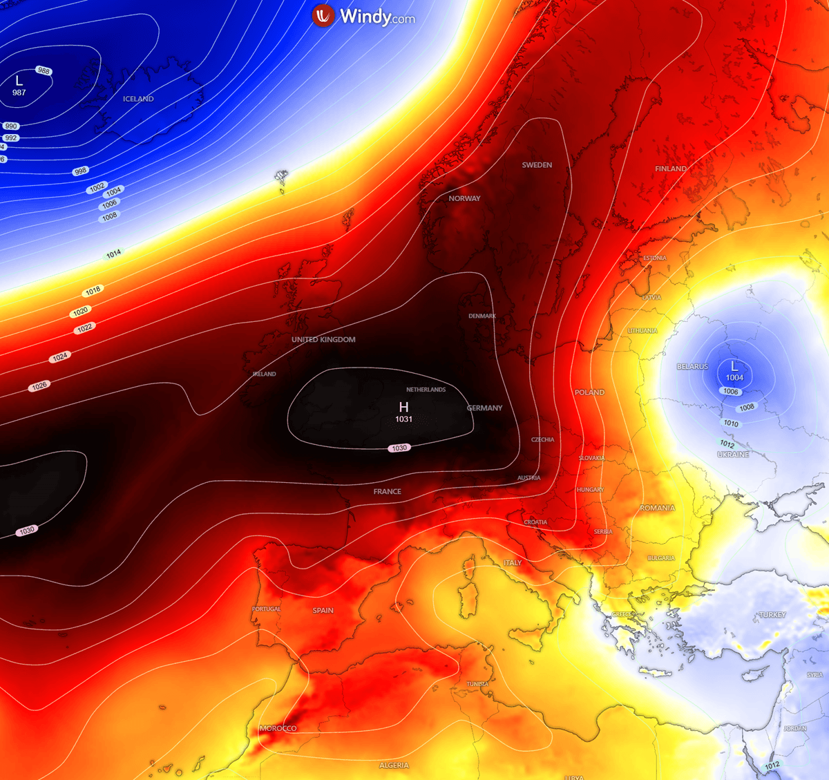
This configuration creates a stark "dipole" pattern across the continent. While Western Europe remains sheltered under the influence of the high-pressure ridge—maintaining relatively mild, above-average temperatures—Eastern Europe has been left vulnerable. A powerful upper-level trough is currently swinging into the eastern half of the continent, acting as a vacuum that pulls frigid, Arctic-origin air masses southward.
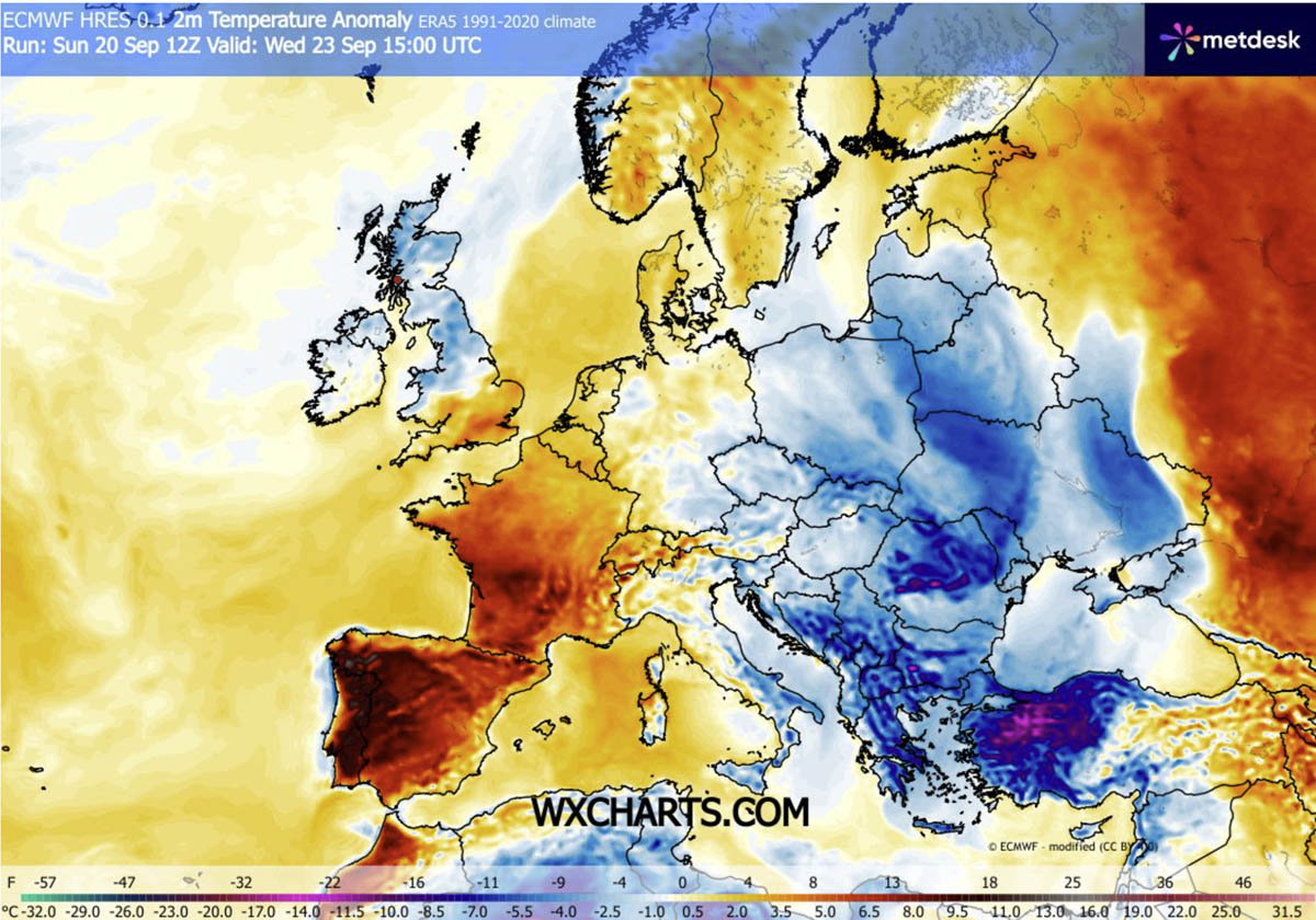
Meteorological data confirms that this cold wave is not a localized event but a sweeping regional phenomenon. By midweek, the influence of this polar blast is projected to penetrate as far south as the Balkan Peninsula, reaching into Greece, the Aegean Sea, and eventually the western regions of Turkey.
Chronology of the Cold Front
The transition from summer-like conditions to autumnal chill is occurring with rapid, almost jarring speed.
Tuesday: The Initial Onset
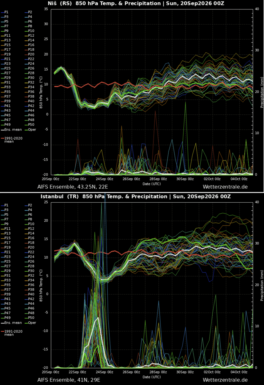
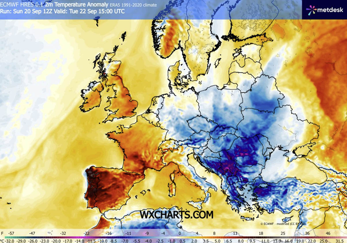
The first signs of the intrusion appeared early Tuesday morning. As the leading edge of the polar front swept across the Balkans, temperature anomalies became immediately apparent. Regions across Serbia, Bosnia, Romania, and Bulgaria experienced a vertical drop in mercury, with midday temperatures falling significantly below the long-term climatic norms for late September.
Mid-Week Peak: The Heart of the Chill
Wednesday marks the zenith of this cold event. As the core of the upper-level trough settles over the south-central Balkans and pivots toward Western Turkey, the thermal disparity will reach its peak. Meteorological charts indicate that parts of Western Turkey and the Aegean region could see temperatures 12 to 16°C colder than typical late-September values.
For many residents in these areas, the transition will be visceral. Following days of persistent warmth, the sudden shift to single-digit lows and brisk, chilly winds will necessitate an immediate adaptation to early-autumn living conditions.
Supporting Data and Meteorological Observations
The severity of this event is best understood through 850 hPa temperature anomaly maps, which strip away the influence of local terrain to reveal the true temperature of the air mass.
Anomalies and Meteograms
Data from the Niš, Serbia, and Istanbul, Turkey, meteograms provide a granular look at the event. These charts show a "cliff-edge" drop in temperature beginning Tuesday. The 850 hPa maps confirm that the air mass flooding into these regions is significantly colder than the historical baseline for this specific week in September.
The contrast is striking: while Western Europe enjoys an extended period of warmth due to the blocking ridge, Eastern Europe is effectively experiencing a "thermal winter" mid-September. The pressure gradients created by the interaction between the western high and the eastern low are also generating high-velocity wind flows, which will exacerbate the perceived cold through wind-chill effects.
Implications: Frosts, Agriculture, and Tourism
Agricultural Risks and First Frosts
One of the most concerning aspects of this rapid cooling is the threat of "first frost." As the cold air mass stabilizes and skies clear behind the passing front, the lack of cloud cover will allow for rapid radiational cooling at the surface.
Agricultural basins, particularly in the Baltic states, the central Balkans, and the low-lying valleys of Romania and Bulgaria, are at high risk. Farmers are being cautioned that early-season frost can be particularly damaging to late-harvest crops that are not yet acclimated to freezing temperatures. Meteorological experts suggest that nighttime lows could reach the low single digits, creating conditions where ground-level freezing becomes highly probable.
High-Altitude Snowfall
For the higher elevations of the Carpathian Mountains and the Northern Balkans, this event represents the first significant winter-like weather of the year. Falling freezing levels will likely trigger the first notable snowfalls of the autumn season. While these accumulations are expected to be temporary, they serve as a stark reminder of the looming winter season.
Disruption to Tourism
The timing of this cold intrusion is particularly disruptive for the Mediterranean and Aegean tourism sectors. In Greece and Western Turkey, the tourist season is typically in full swing during late September. The sudden drop in daytime highs—likely resulting in temperatures in the upper 10s to low 20s (Celsius)—will force a rapid shift in expectations for travelers who arrived expecting the lingering warmth of a Mediterranean summer.
Official Responses and Long-Term Outlook
While local weather services have issued standard advisories regarding the drop in temperatures and potential frost, the broader scientific community is viewing this event as a vital case study in atmospheric blocking patterns.
The Path Toward Recovery
The current model projections suggest that this cold intrusion will be relatively short-lived. By the end of the week, the influence of the polar low will begin to wane. As the upper-level ridge currently anchored over Western Europe begins to expand eastward, a gradual recovery in temperatures is expected.
However, the "dipole" structure of the European climate is expected to persist until the very end of September. This means that while the most extreme anomalies will dissipate, the region may remain in a state of flux, with temperatures hovering near or slightly below average before a more settled pattern emerges as October approaches.
Looking Ahead: A Winter of Volatility?
Meteorologists are already drawing parallels between this current blocking pattern and larger, more systemic shifts in the Northern Hemisphere. Recent reports regarding the emergence of a new Polar Vortex suggest that the winter of 2026/2027 may be characterized by high volatility.
The atmospheric instability seen this week is, for many analysts, a precursor to what may be a winter defined by frequent stratospheric warming events and subsequent disruptions to the polar jet stream. As this week’s cold front retreats, the focus of the meteorological community will remain on whether these blocking patterns become a more permanent feature of the autumn and winter months, potentially leading to a season of unpredictable and rapid climate swings.
Conclusion
The late-September cold blast serves as a potent reminder of the atmospheric power contained within blocking ridges. By forcing a fundamental shift in the movement of polar air, the current synoptic setup has effectively rewritten the weather map for Eastern Europe.
As the region moves through the remainder of this week, the primary focus for residents and industries alike will be the management of the immediate thermal shock. From the first frost of the season to the unexpected dusting of snow on mountain peaks, the environment is shifting rapidly. While warmth is set to return as the blocking ridge shifts, the memory of this sharp, sudden intrusion will likely persist as a reminder of the volatile nature of the 2026 autumn season.
Data and imagery for this report were provided by WetterZentrale and WXcharts. Stay tuned for further updates as the meteorological situation develops through the end of the week.