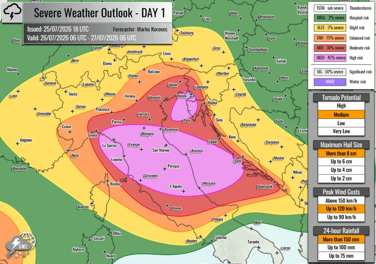
Issued: July 25, 2026
Valid: July 26, 2026, 06 UTC – July 27, 2026, 06 UTC
Forecaster: Marko Korošec, Severe Weather Europe
Executive Summary: A Volatile Sunday Ahead
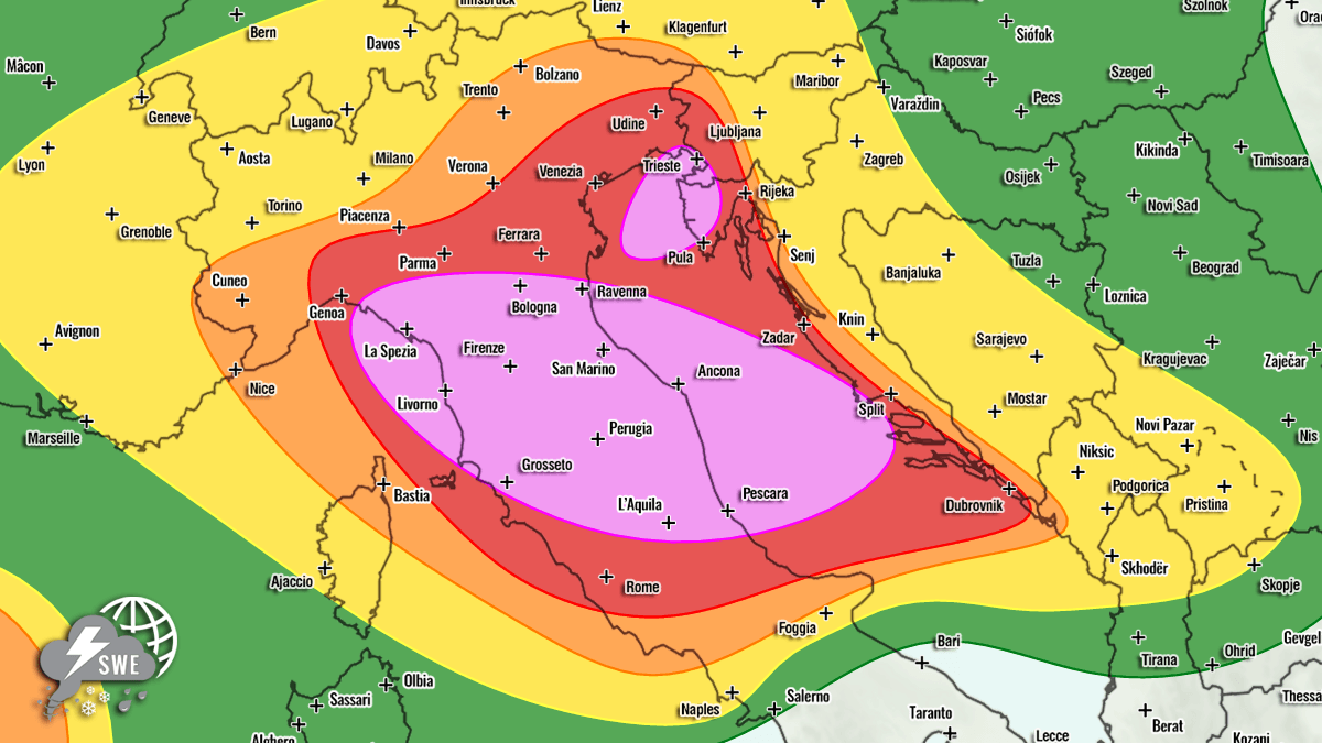
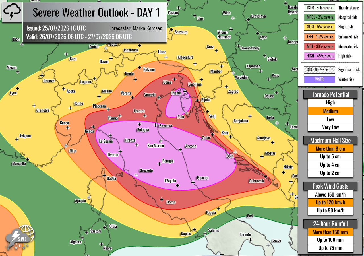
A major meteorological event is set to unfold across the north-central Mediterranean and the Adriatic Sea on Sunday, July 26, 2026. Meteorologists have issued "HIGH" and "MDT" (Moderate) risk designations for large swaths of Italy and the Adriatic coastline, warning of a potent, multi-hazard storm outbreak.
The atmospheric setup is characterized by a high-octane collision between extreme heatwave-induced instability and a dynamic upper-level trough moving in from northern Europe. This combination is expected to produce severe, potentially record-breaking thunderstorms capable of spawning "giant" hail exceeding 10 centimeters in diameter, damaging wind gusts, flash flooding, and tornadoes. Residents, tourists, and local authorities in the affected regions are urged to monitor weather developments closely as the situation transitions from a period of intense heat to one of extreme convective activity.
Synoptic Overview: The Mechanics of the Storm
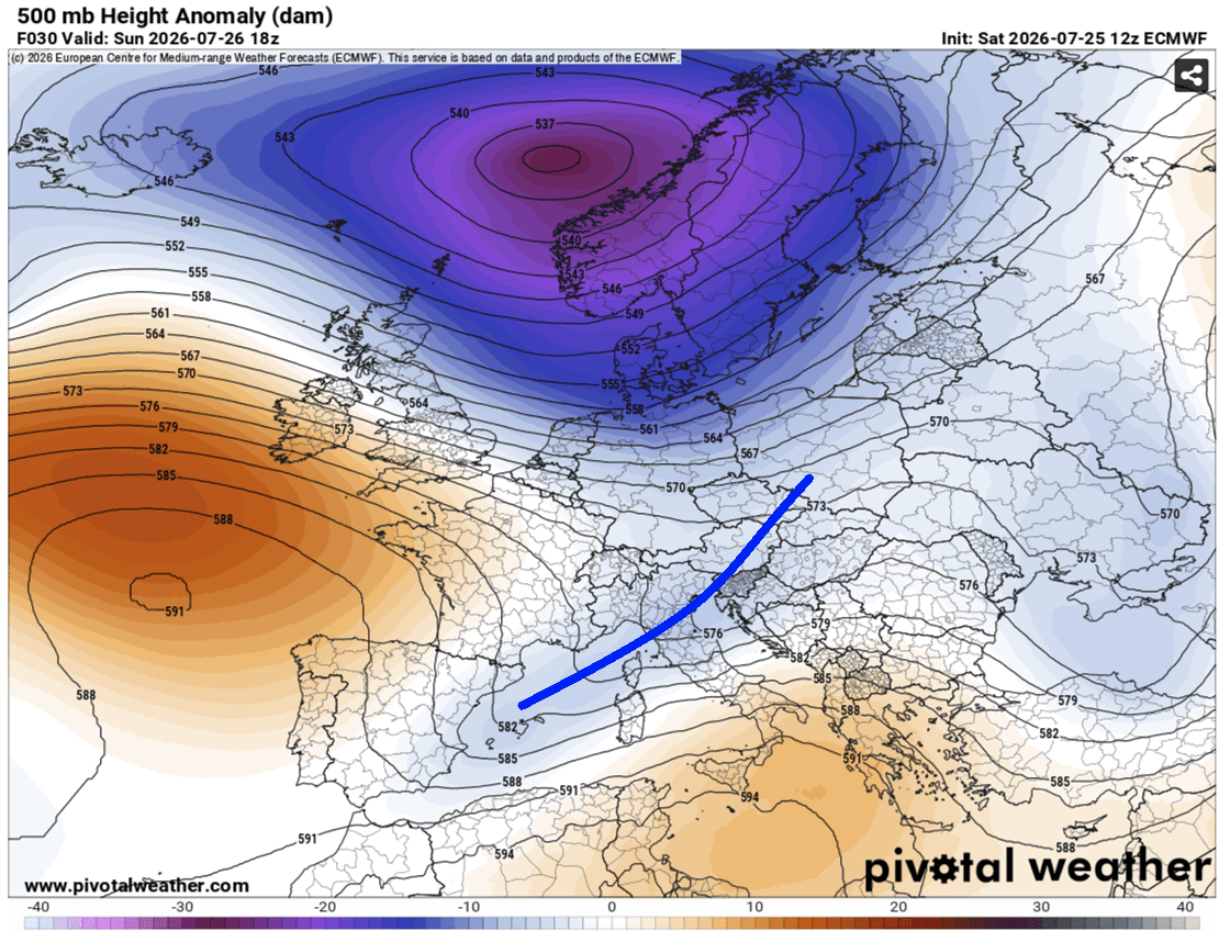
The current weather pattern is dominated by a deep, near-stationary upper-level low-pressure system anchored over northern Europe. This low is effectively "locked" between two formidable high-pressure ridges—one residing over the North Atlantic and another over the Russian Federation.
This blocking pattern has forced a secondary, aggressive wave to track across central Europe. As this wave reaches the Mediterranean, it is interacting with an exceptionally warm, moisture-laden surface layer—a direct consequence of the recent, sustained heatwave that has gripped the region. At the surface, a secondary low-pressure center is developing in the northern Mediterranean. This system is driving a sharp, fast-moving cold front that will sweep from west to east, crossing the Alps and the Apennines before slamming into the Adriatic Sea and the western Balkans.
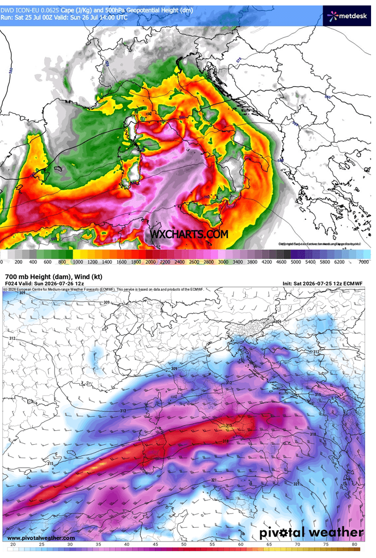
The energy available for these storms—measured by Convective Available Potential Energy (CAPE)—is projected to reach 2,000 to 3,000+ J/kg across the Tyrrhenian, Ligurian, and central Adriatic Seas. When combined with strong mid-level wind shear and an intense jet stream exit region, the environment is primed for explosive storm development.
Chronology of Expected Impacts
The event is expected to follow a distinct progression throughout the day on Sunday:
- Early Morning (06:00 – 10:00 UTC): The initial phase begins as the upper-level wave reaches the Ligurian Bay. Thunderstorms will initiate over the water and quickly push toward the Apennine Mountains. Early morning commuters and coastal areas in northern Italy should prepare for the first round of heavy precipitation.
- Mid-Day (10:00 – 15:00 UTC): Convection is expected to intensify significantly. As the storm cells move over the rugged terrain of northern Italy, high Precipitable Water (PWAT) values—forecast between 45 and 60 mm—will lead to "training" thunderstorms. These are storms that follow one another over the same location, dramatically increasing the risk of localized flash flooding.
- Late Afternoon to Evening (15:00 – 21:00 UTC): The focus shifts toward the North Adriatic. Stationary convergence zones are expected to form, particularly along the coasts of Istria (Croatia) and southwestern Slovenia. This period carries the highest risk for severe tornadic activity as the low-level jet strengthens, increasing storm-relative helicity.
- Overnight (21:00 – 06:00 UTC): The storm clusters will consolidate and track eastward toward the western Balkans, with the primary threat transitioning from discrete supercells to a large, long-lived convective system.
Regional Breakdown of Threats
Italy, Austria, and the Alpine Corridor
The "HIGH" risk designation for central and northern Italy reflects the extreme threat level. Here, the primary hazards include wind-driven hail capable of causing significant structural damage and intense, localized downpours. The mountainous terrain of the Apennines will likely exacerbate the flash flood threat, as rapid runoff will overwhelm smaller drainage basins. In the Alpine corridors of Austria and Switzerland, while the threat of large hail is slightly lower than on the coast, severe wind gusts and torrential rain remain significant concerns for transit and tourism.
North Adriatic: The Convergence Zone
The North Adriatic, spanning from the Istrian Peninsula in Croatia to the southwestern borders of Slovenia, faces a particularly dangerous scenario. The presence of a low-level jet creates the perfect environment for "tornadic supercells." Meteorologists are particularly concerned about the potential for waterspouts moving onshore, which could impact peak-season tourist populations along the coast. Rainfall accumulations in this zone are projected to reach 100–200 mm within a 6–12 hour window, which would likely result in catastrophic flash flooding.
Western Mediterranean and Eastern Europe
Beyond the primary impact zones, isolated severe storms are expected to affect the Balearic Islands and northeastern Spain, where an "ENH" (Enhanced) risk is in effect. Furthermore, the eastern edge of the system will bring instability to southwestern Russia. In these regions, organized supercells may produce damaging winds and large hail, though the overall coverage of storms is expected to be more sporadic compared to the Italian and Adriatic centers.
Implications for Public Safety and Infrastructure
The timing of this outbreak coincides with the height of the European summer tourist season. Millions of travelers currently occupy coastal campsites, beach resorts, and mountain trails—all of which are highly vulnerable to the forecast weather conditions.
Flash Flood Risks
The excessive rainfall predicted—especially in the Istrian and northern Italian regions—poses a severe threat to infrastructure. Urban drainage systems, particularly in older, historic city centers, may be unable to cope with 100+ mm of rain in such a short duration. Travelers are advised to avoid low-lying areas, canyons, and dry riverbeds.
Tornado and Wind Hazards
The "giant" hail potential (10+ cm) represents a danger not only to vehicles and property but also to human safety. With such large stones, there is a risk of significant injury to those caught outdoors. Furthermore, the tornadic potential along the Adriatic coast requires immediate attention; local authorities should ensure that early warning systems are active and that tourists, who may be less familiar with local weather patterns, receive clear instructions on how to seek shelter.
Aviation and Maritime Disruptions
The intense jet stream activity and convective turbulence will undoubtedly impact aviation across the region. Delays and cancellations at major hubs in Northern Italy and the Adriatic are highly likely. Similarly, the maritime sector faces a significant threat. Sailors and those operating small vessels in the Adriatic should seek safe harbor well before the arrival of the cold front, as rapid wind shifts and sudden, violent gusts can make navigation impossible.
Conclusion: Preparation is Paramount
The meteorological data for July 26–27, 2026, depicts an environment that is "loaded" with energy. While such events are part of the complex Mediterranean climate, the specific combination of high heat, moisture transport, and strong upper-level dynamics makes this an outlier event.
Residents and visitors are encouraged to:
- Monitor Official Sources: Follow updates from national meteorological services (e.g., Servizio Meteorologico, DHMZ).
- Secure Property: Ensure outdoor furniture, signage, and equipment are secured against high winds.
- Plan Travel Carefully: Expect significant disruptions to road and rail travel. If you are in a high-risk area, avoid non-essential travel during the peak of the storm activity.
- Prioritize Safety: If thunder is heard or dark, ominous clouds approach, move indoors immediately to a sturdy structure away from windows.
As this severe weather outbreak progresses, the meteorological community will continue to refine these forecasts. The severity of this system is a reminder of the need for preparedness in the face of increasingly volatile weather patterns across the European continent.
Data and imagery provided courtesy of Meteoadriatic, Wxcharts, and PivotalWeather. This report is intended for informational purposes; please consult your local government weather warnings for real-time safety instructions.