In a display of atmospheric volatility rarely witnessed in modern meteorological history, Hurricane Polo has emerged as a record-shattering force off Mexico’s Pacific coast. As of late September 2026, this "monster" storm has solidified its place in the annals of tropical cyclone history, reaching Category 5 status on the Saffir-Simpson scale not once, but three times within a single week. With sustained winds peaking at 180 mph (285 km/h) and an atmospheric pressure that plummeted to a staggering 892 mbar, Polo stands as the second-most intense hurricane ever recorded in the Pacific basin, trailing only the historic Hurricane Patricia of 2015.
The storm’s rapid intensification—a process where a system gains significant wind speed in a short window—has been nothing short of explosive. Transforming from a tropical storm to a high-end Category 5 system in under 24 hours, Polo has capitalized on a perfect storm of environmental conditions, fueled by an ongoing, record-breaking "Super El Niño."
The Anatomy of an Atmospheric Titan
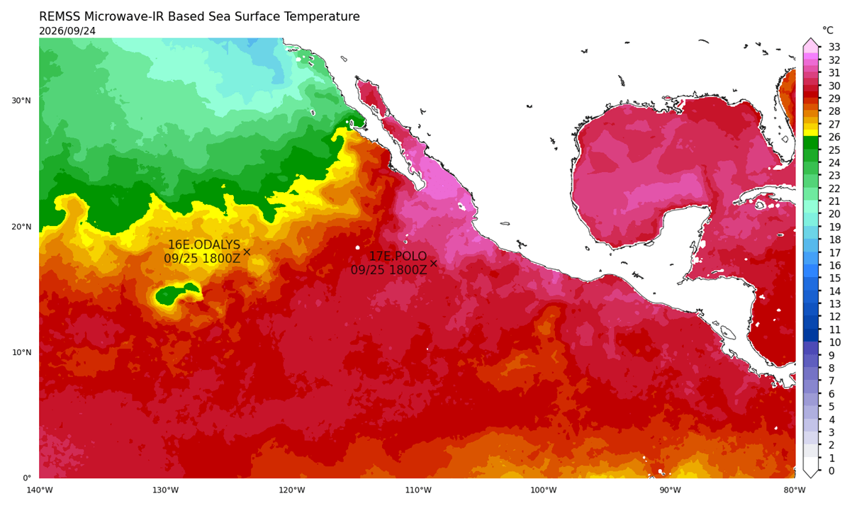
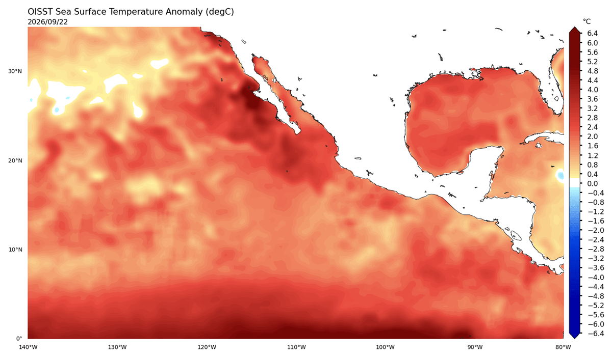
Hurricane Polo’s power is driven by an exceptionally favorable thermodynamic environment. Sea surface temperatures (SSTs) across the eastern tropical Pacific are currently hovering between 31°C and 32°C—roughly 4–6°C above the seasonal average for late September. In the world of tropical meteorology, these temperatures act as high-octane fuel.
When tropical systems ingest this level of thermal energy, the resulting dew points and near-surface instability allow for massive, rapid convective development. Coupled with an environment characterized by extremely low vertical wind shear, Polo was afforded the "clean" atmospheric path required to tighten its inner core and expand its wind field.
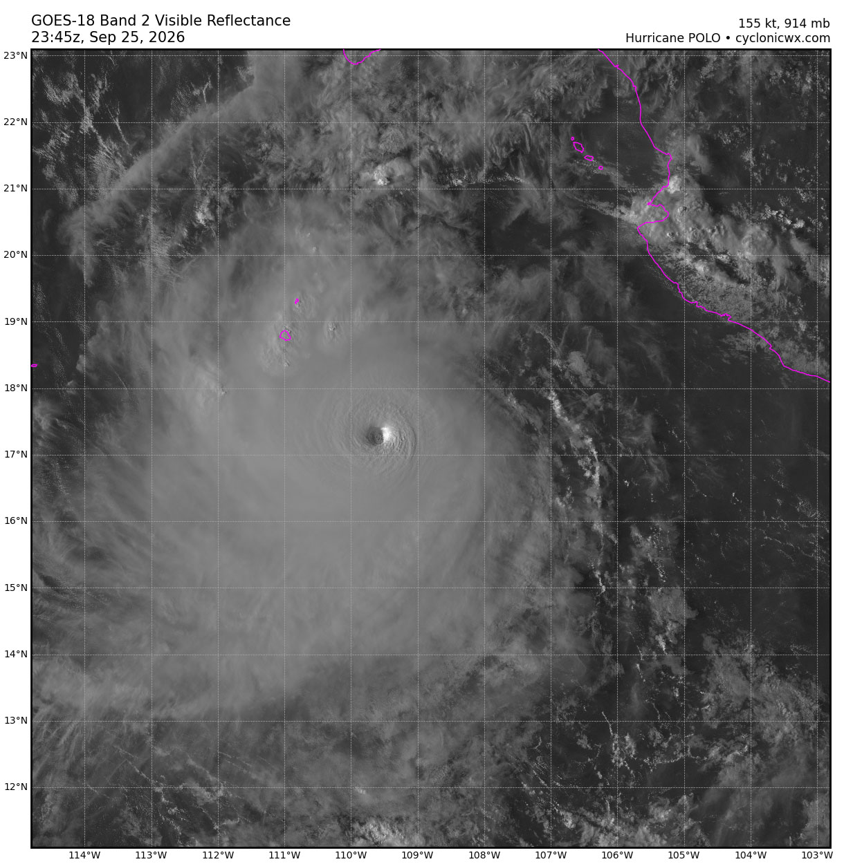
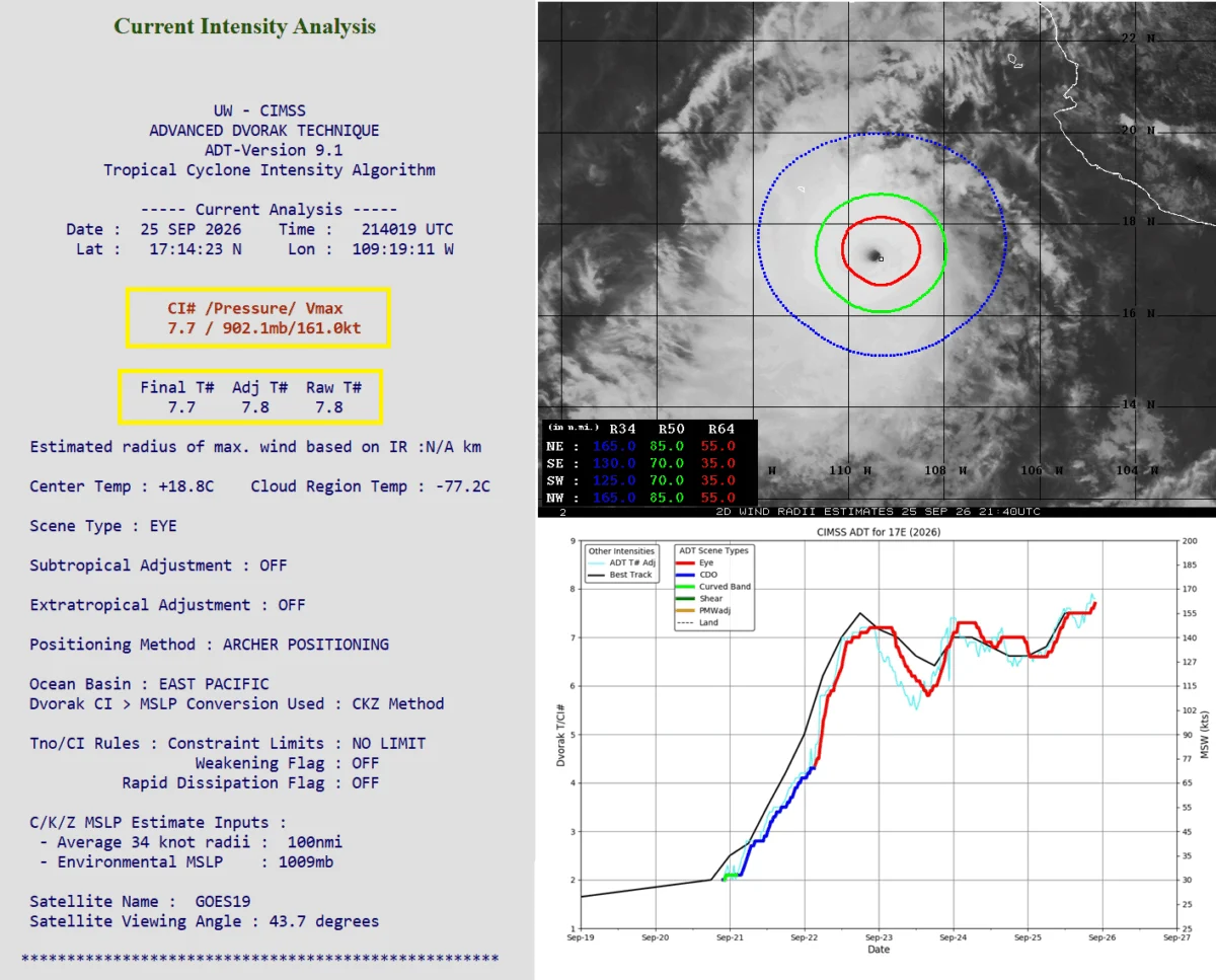
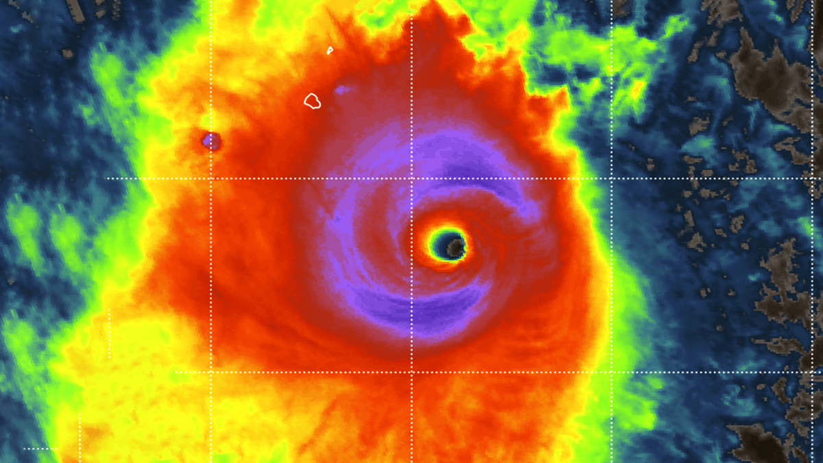
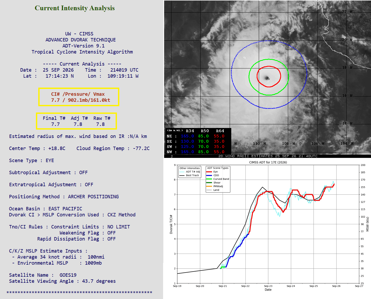
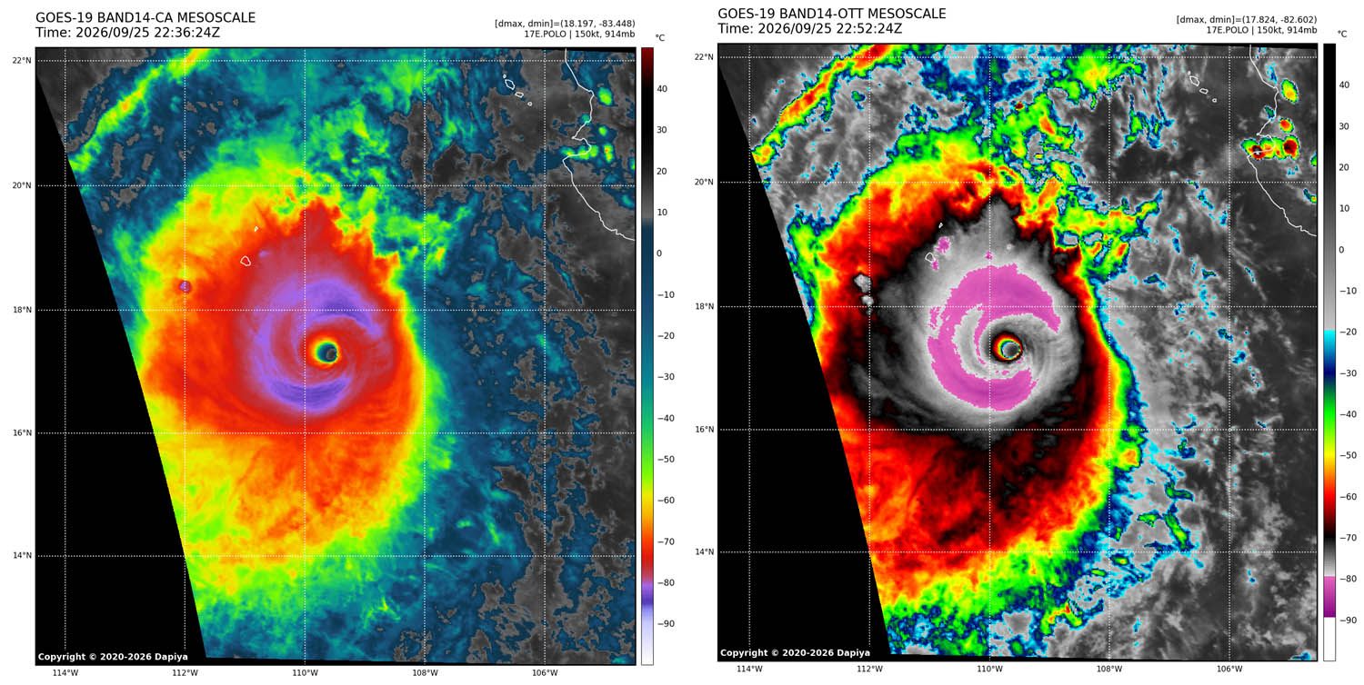
The storm’s structure is equally impressive. Satellite imagery reveals a "buzzsaw" symmetry, with a perfectly formed eye surrounded by a sprawling, violent circulation. Hurricane Hunter reconnaissance missions, which have flown directly into the heart of the storm, confirmed the central pressure of 892 hPa, a reading indicative of a system pushing the absolute theoretical limits of hurricane intensity.
Chronology of a Record-Breaking Event
The lifecycle of Hurricane Polo has been defined by rapid fluctuations and sustained power.
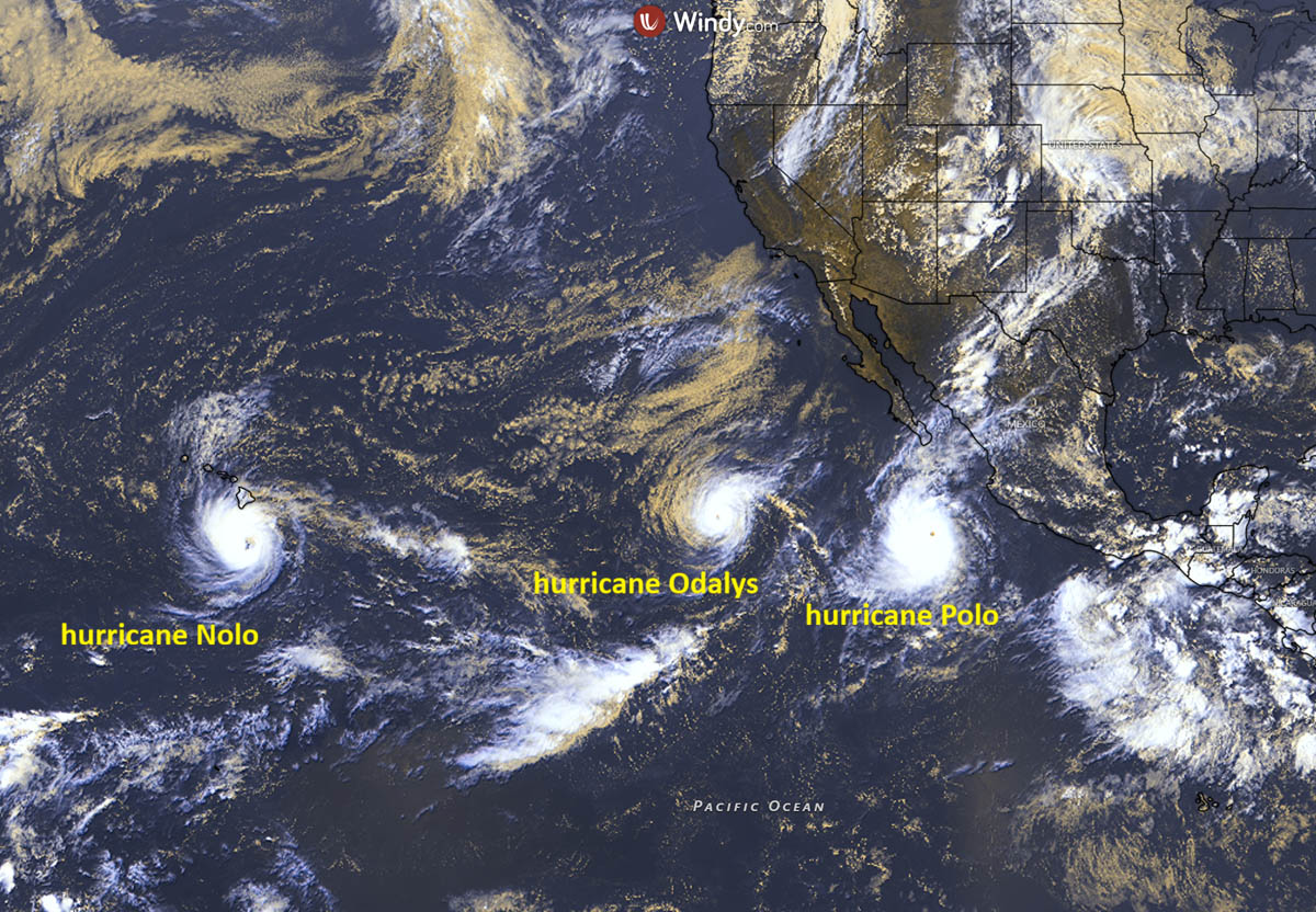
- Early Week: The Initial Surge: Polo began its life as a modest disturbance before entering a period of rapid intensification early in the week. Within 24 hours, it bypassed multiple categories to emerge as a Category 5 powerhouse.
- Thursday Night: The Eyewall Replacement Cycle: Like many high-intensity systems, Polo underwent a classic eyewall replacement cycle (ERC). During this process, the inner eyewall collapsed, and a new, wider outer eyewall formed. While such cycles typically cause a temporary dip in maximum sustained winds, Polo emerged from this process larger, more structured, and even more dangerous, with a wider radius of destructive winds.
- Friday: Re-intensification: Following the completion of the ERC, the storm began a second phase of strengthening, re-establishing its Category 5 status and sustaining winds of 180 mph.
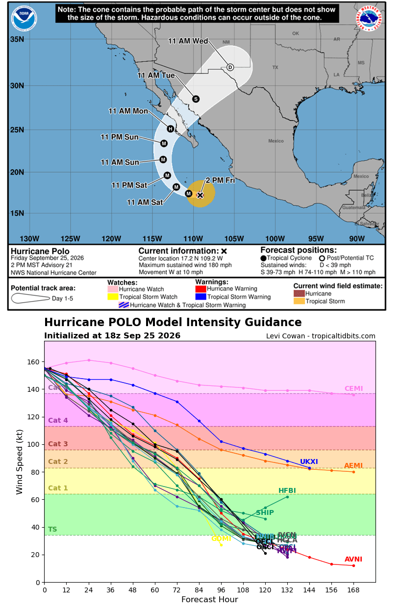
- The Weekend Outlook: As the storm tracks west-northwest, it remains in a pocket of high ocean heat content. While it is expected to encounter slightly less favorable conditions as it approaches the Baja California Peninsula, its momentum and immense size suggest it will remain a life-threatening, high-end storm through the weekend.
Supporting Data: A Season of Extremes
Hurricane Polo does not exist in a vacuum. It is part of an unprecedented surge in tropical activity in the Pacific. So far this season, the Eastern Pacific has produced 19 tropical systems, including nine hurricanes and six "major" hurricanes (Category 3 or higher).
Global Context of Category 5 Activity
Polo is the fifth Category 5 storm globally in 2026, joining a rare list of intense systems:
- Tropical Cyclone Horacio (South Indian Ocean, Feb 23)
- Super Typhoon Sinlaku (Western Pacific, April 12)
- Super Typhoon Bavi (Western Pacific, July 5)
- Hurricane Genevieve (Eastern Pacific, July 27)
- Hurricane Polo (Eastern Pacific, September)
The current sea surface temperature anomalies are the primary culprit. Off the coast of the Baja California Peninsula, where the storm is currently tracking, temperatures are exceeding long-term averages by 5–6°C. This warmth ensures that any system entering the region is virtually guaranteed to maintain or intensify its core structure.
Regional Impacts and Forecasts
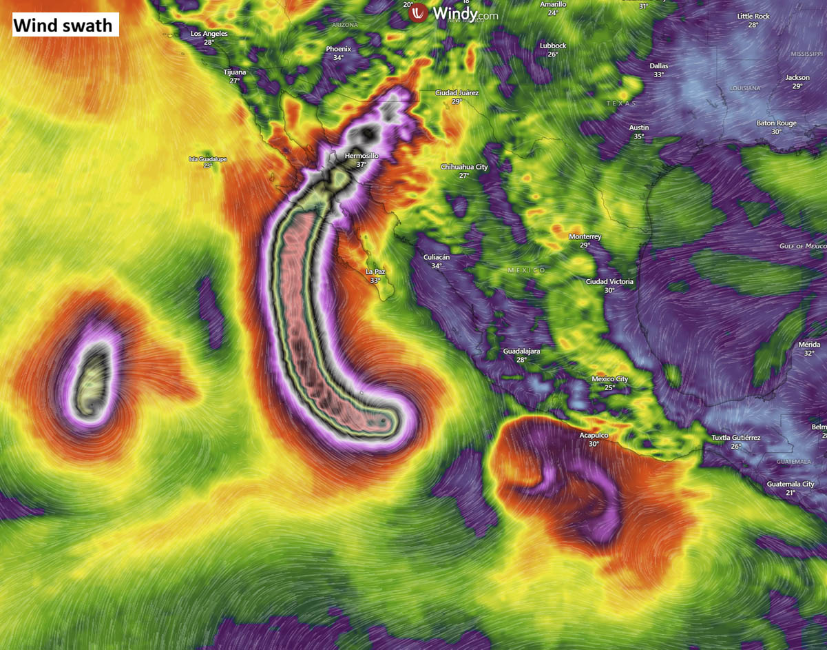
While current model guidance suggests that the most violent portion of the core will remain slightly offshore, the sheer size of the storm makes the impact radius enormous.
The Baja California Threat
The primary concern for meteorologists is the storm’s trajectory toward the Baja California Peninsula, expected to commence late Sunday into Monday. Even if the storm undergoes a slight weakening trend due to cooler waters near the coast, the wind field is so expansive that the peninsula will face conditions equivalent to a major Category 3 or 4 hurricane.
Expected impacts include:
- Wind: Sustained winds of 200–250 km/h in the most affected coastal areas.
- Rainfall: Predictions suggest 10–15 inches (250–400 mm) of rain near the core path. Because of the mountainous terrain of the Baja Peninsula, this volume of water is almost certain to trigger catastrophic, life-threatening flash floods and mudslides.
- Storm Surge: A significant rise in sea level is expected, with massive waves battering the western coastline, threatening infrastructure and maritime operations.
Secondary Impacts
Coastal regions from Guerrero to Jalisco have already felt the effects of the storm’s outer rainbands. Torrential rainfall—ranging from 150 to 200 mm—has led to river flooding and the closure of key ports, including Acapulco, Zihuatanejo, and Manzanillo. Emergency management agencies have been forced to deploy widespread evacuation orders and shelter deployments to protect residents from the encroaching floodwaters.
Official Responses and Safety Protocols
National meteorological services and emergency management agencies in Mexico have escalated their warnings to the highest levels. The "Super El Niño" conditions, which have created a persistent, warm, and low-shear environment, are being closely monitored by regional climate centers to predict potential secondary landfalls in northwestern Mexico early next week.
Public safety messaging has focused on the "deceptive" nature of the storm’s weakening. Officials are warning residents that even as the central pressure rises and peak winds decrease, the storm’s massive physical footprint means that the threat of flooding and surge remains undiminished.
"We are dealing with a storm of historical proportions," stated one regional emergency director. "The focus must move beyond the category number and toward the total impact of wind, surge, and water. This is a multi-hazard event."
Implications: The "New Normal" in a Warming Climate
Hurricane Polo serves as a stark reminder of the evolving nature of tropical cyclones in a warming world. The frequency of rapid intensification events—going from a minor storm to a Category 5 in under 24 hours—is becoming a recurring theme in the Pacific.
The combination of a Super El Niño and record-breaking sea surface temperatures is creating an environment where the "ceiling" for hurricane intensity is being pushed higher. Historically, storms of this magnitude were once-in-a-generation events; in the 2026 season, they have become a regular occurrence.
As Polo continues its path toward the Baja Peninsula, the international meteorological community is watching with bated breath. The data gathered from this storm—from its eyewall replacement cycles to its interaction with the extreme heat content of the Pacific—will undoubtedly be the subject of climate studies for years to come. For the residents in the path of this monster, however, the priority remains survival in the face of one of the most powerful storms the Pacific has ever seen.
Data and imagery provided by Windy, CyclonicWX, and Tropical Tidbits. This report will be updated as new reconnaissance data becomes available.