As the global meteorological community turns its eyes toward the closing months of 2026, one atmospheric phenomenon is dominating the long-range outlook: a developing Super El Niño. Current ocean data and predictive modeling suggest that the upcoming winter season will be defined by a significant, high-amplitude split-flow pattern across North America and Europe. With sea surface temperatures already breaching the "Extreme" threshold, the stage is set for a winter that could rank among the most anomalous in modern records.

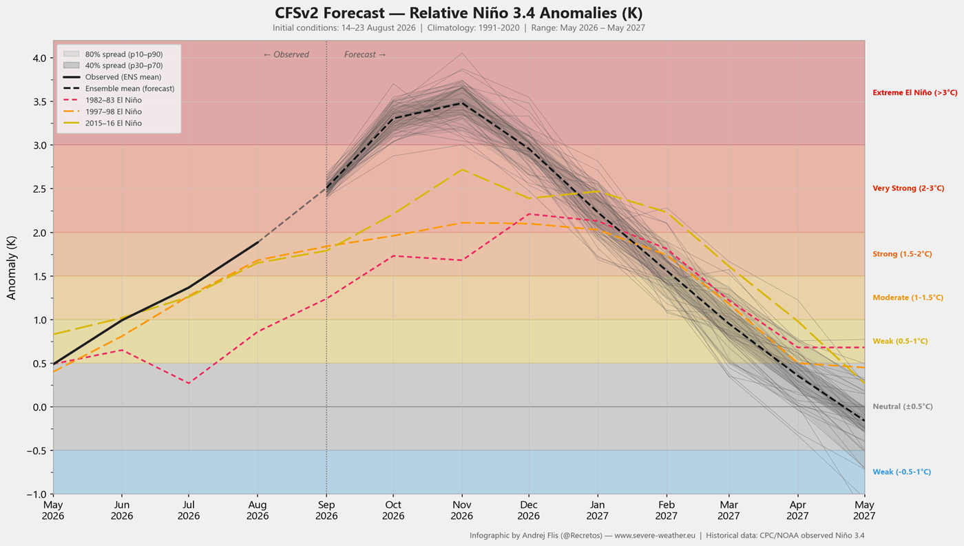
This in-depth forecast analyzes the interplay between oceanic heat, the atmospheric "Walker Cell" circulation, and the potential for a mid-winter Polar Vortex disruption. By synthesizing data from the ECMWF (European Centre for Medium-Range Weather Forecasts) and the NCEP (National Centers for Environmental Prediction) CFSv2, we can begin to map out what this historic climate driver means for the United States, Canada, and the European continent.
Main Facts: The Engine of the Super El Niño
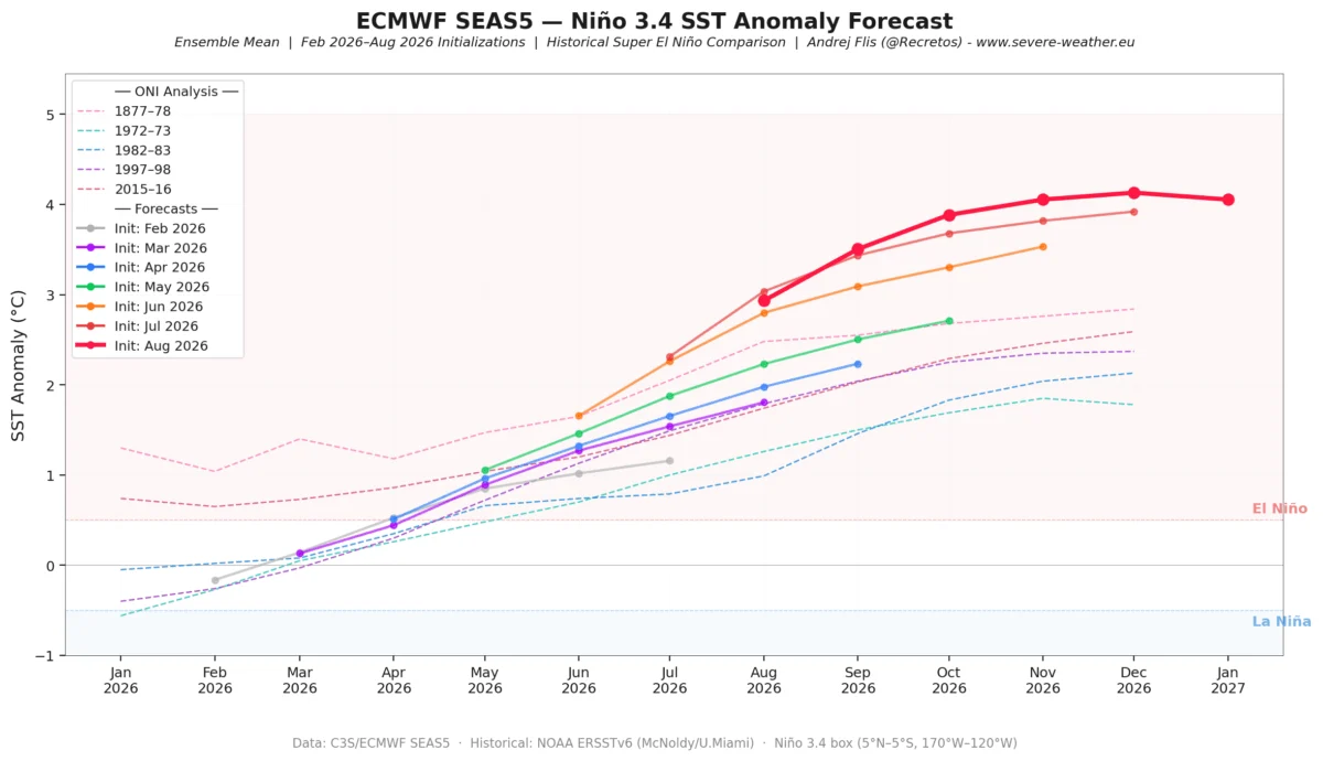
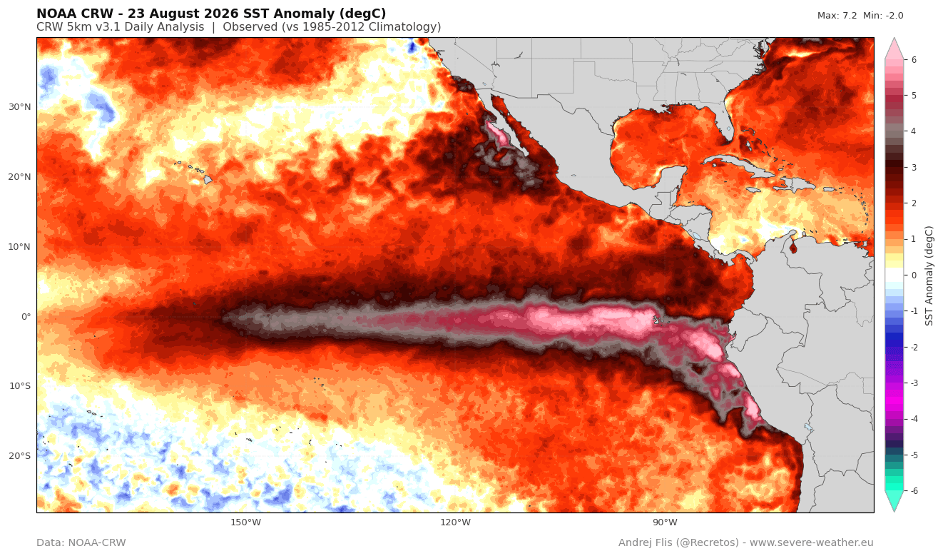
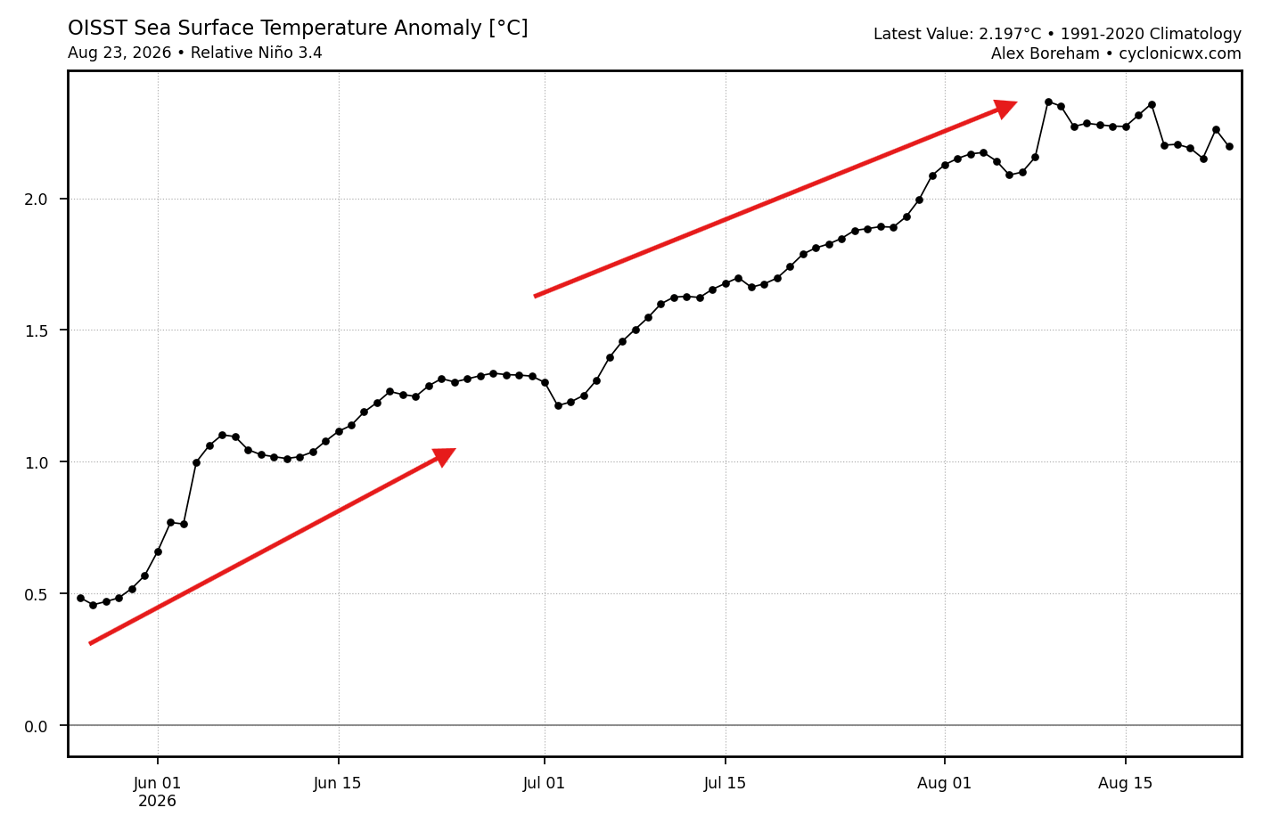
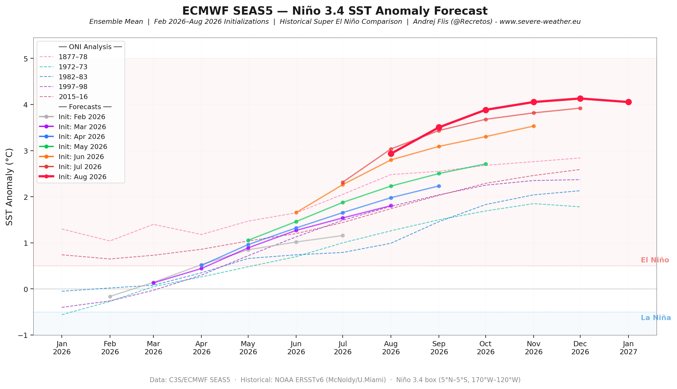
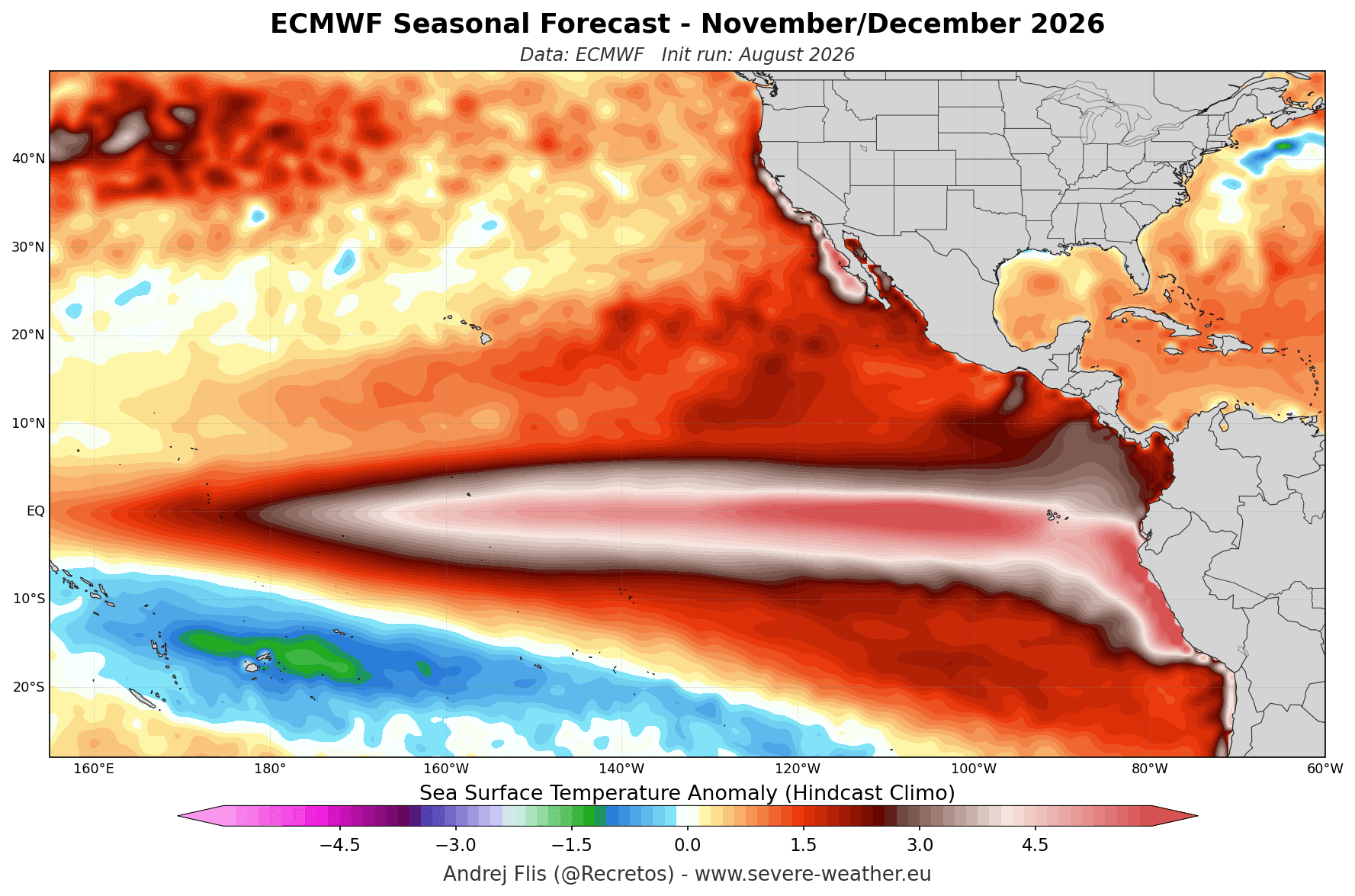
The current climate trajectory is being driven by a profound warming in the central and eastern tropical Pacific. To be classified as a "Super" El Niño, the Niño 3.4 sea surface temperature (SST) anomalies must sustain values significantly above the +2.0°C threshold. Recent NOAA Coral Reef Watch data indicates that we have not only reached this threshold but are witnessing anomalies exceeding 6°C above normal in localized regions.
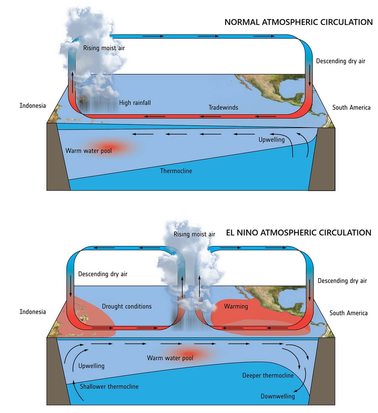
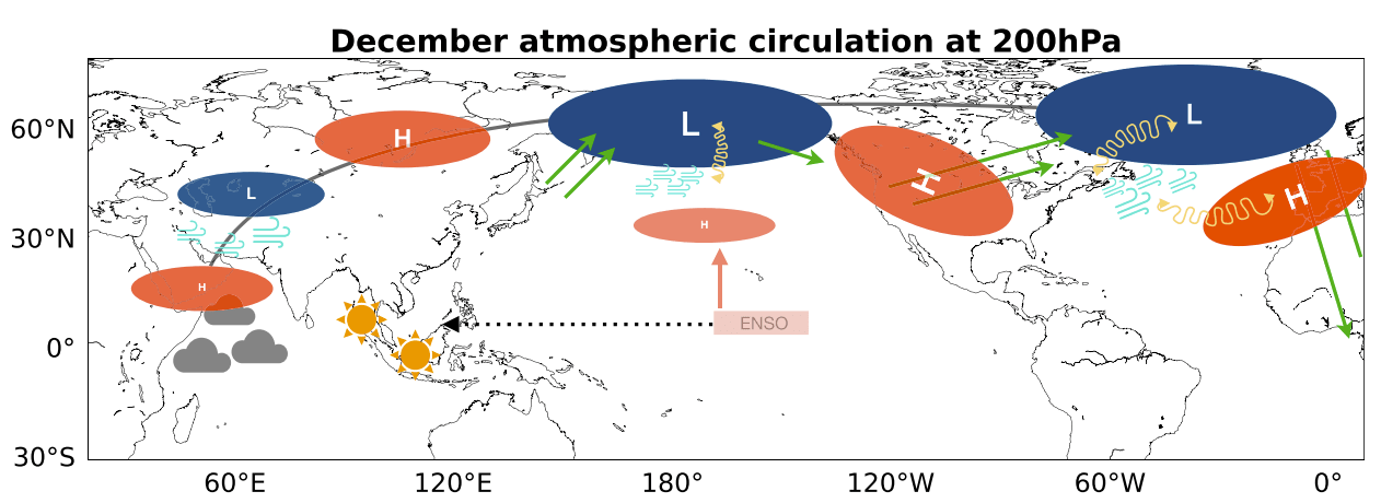
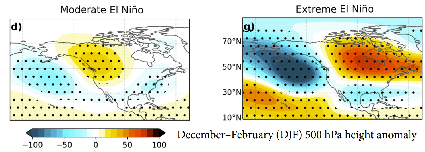
At the heart of this event is a powerful subsurface "downwelling Kelvin Wave." This massive pulse of warm water, spanning the top 250 meters of the Pacific, acts as the fuel for the atmosphere. As these warm waters surface, they shift the Walker Circulation—the massive loop of air that governs global weather—forcing a realignment of the jet stream. Unlike moderate events, this Super El Niño is exerting enough energy to create a planetary "wave train," a domino effect of high and low-pressure systems that will dictate weather patterns from the Pacific coast of North America to the Atlantic shores of Europe.
Chronology of Development: From Summer Heat to Winter Extremes
The progression of this event has been rapid and consistent. Throughout the late summer of 2026, subsurface monitoring revealed the intensification of the Kelvin Wave, confirming that this was not a transient fluctuation but a sustained, strengthening cycle.
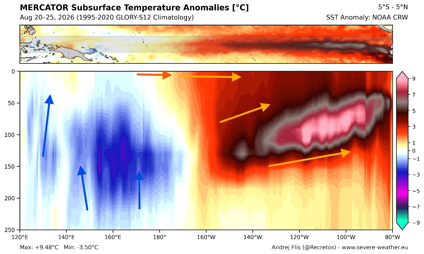
- Late Summer 2026: Initial surge in subsurface temperatures across the equatorial Pacific, signaling the onset of the Super event.
- Autumn 2026: Atmospheric coupling occurs, where the ocean-atmosphere interaction begins to force the jet stream into a "split-flow" configuration.
- December 2026 – January 2027: The peak of the event, where the pressure anomalies are predicted to be at their most amplified state, creating a permanent high-pressure ridge over Canada and a deep, active low-pressure trough over the southern United States.
- February 2027: A period of potential instability, where the interaction between the El Niño-driven jet stream and a weakening Polar Vortex could lead to intensified cold-air outbreaks.
Supporting Data: Model Convergence and Record Strength
The reliability of this forecast is bolstered by the remarkable agreement between major climate models. The ECMWF SEAS5, consistently regarded as the gold standard for seasonal forecasting, has shown a "stepping" trend—each successive monthly update has pushed the peak anomaly higher, now firmly placing the 2026/2027 event in record-challenging territory.
The NMME (North American Multi-Model Ensemble) confirms this outlook. By aggregating various global models, the NMME provides a consensus view: a clear divide in the North American climate. While the models differ slightly on the exact timing of moisture arrival, they are uniform in their depiction of a northward-shifted polar jet and an intensified, moisture-heavy subtropical jet.
The Polar Vortex Connection
Perhaps the most critical factor for late-winter volatility is the state of the stratospheric Polar Vortex. Current long-range simulations from both the ECMWF and the UKMO (United Kingdom Met Office) show a distinct deceleration of zonal winds at the 10hPa level (the stratosphere) as we approach January 2027. This deceleration is a precursor to a potential Sudden Stratospheric Warming (SSW) event. If the vortex weakens sufficiently, the "Polar Express"—the descent of arctic air into the mid-latitudes—could interrupt the otherwise mild El Niño winter, particularly in the central and eastern United States.
Regional Implications: A Tale of Two Winters
North America
The defining feature of this winter will be the North-South divide.
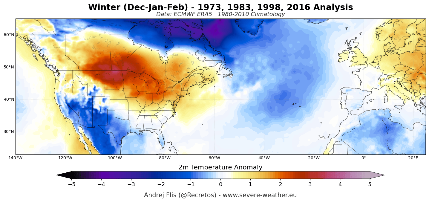
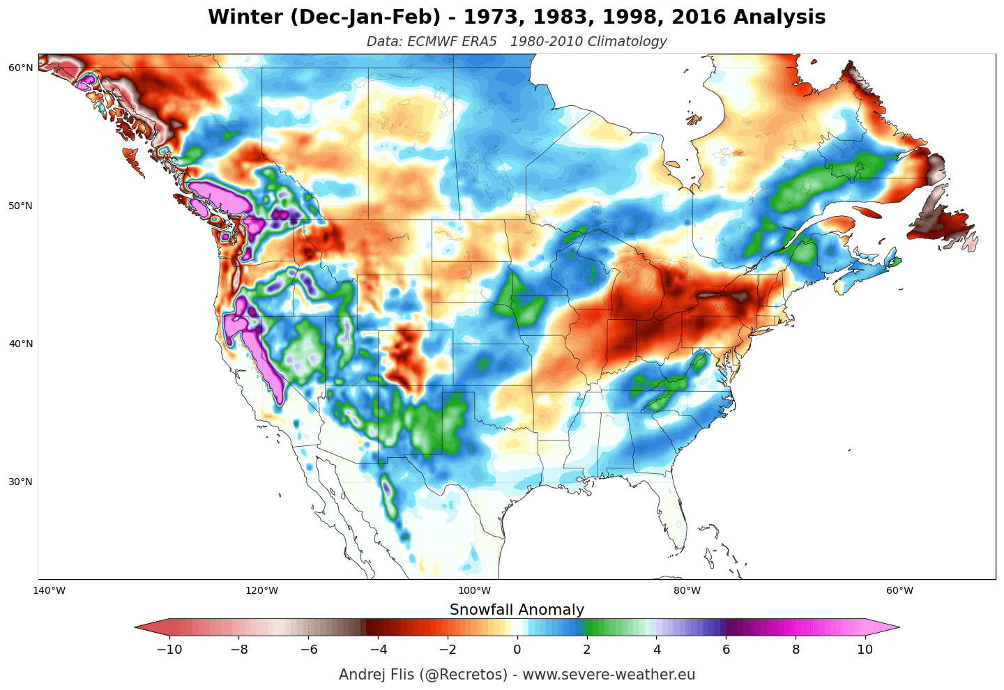
- The North (Canada/Northern US): Under the influence of a persistent high-pressure ridge, these regions can expect a warmer-than-average winter with suppressed snowfall. For ski resorts in the Pacific Northwest and the Northern Rockies, the season may be defined by inconsistent cover and rain-on-snow events.
- The South (Southern US/Gulf Coast): An amplified subtropical jet stream will act as a "moisture highway." Expect higher-than-average precipitation, with significant snowfall potential for the Sierra Nevada, the Four Corners region, and the Southern Rockies. The Southeastern US is likely to see increased cloud cover and cooler temperatures due to the persistent southern storm track.
Europe
The European outlook is heavily influenced by the North Atlantic Oscillation (NAO), which, in a Super El Niño year, tends toward a positive, mild phase.
- Temperature: Most of the continent is forecast to experience above-average temperatures as mild, moist air from the Atlantic dominates the winter flow.
- Snowfall: The lowland regions of Western and Central Europe are likely to face a "brown winter" with frequent rain and limited snow. However, high-elevation resorts (above 1,800m) in the Alps may benefit from the abundant moisture, provided temperatures remain low enough for snow. The most reliable snowpack will be found in the far north and northeast.
Official Perspective and Scientific Context
The scientific community emphasizes that while El Niño provides the "climate backdrop," it does not dictate daily weather. The atmosphere remains a chaotic system. However, the sheer magnitude of the 2026/2027 event reduces the "noise" of smaller-scale weather patterns, making the seasonal trends more statistically significant than in neutral years.
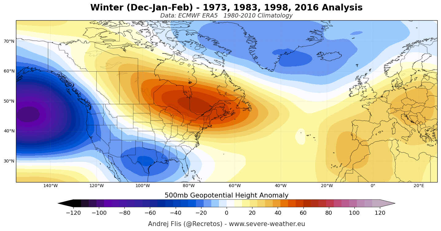
The research into past "Super" events, such as those of 1982/83, 1997/98, and 2015/16, highlights that the "split-flow" pattern is not just a theoretical model but a historical reality. These past winters consistently demonstrated the same atmospheric highway over the southern United States and the same blocking patterns over Canada.
Summary of Risks
The primary risk for the upcoming winter is the unpredictability of the Polar Vortex. While the El Niño-driven pattern is the baseline, an SSW event could radically shift the outlook for February. Citizens, municipal planners, and the agricultural sector are advised to monitor the December updates, as the transition from early to mid-winter will be the critical window for determining if the Polar Vortex holds or breaks.
Conclusion
Winter 2026/2027 is shaping up to be an atmospheric masterclass in the influence of Pacific ocean temperatures. With a Super El Niño providing a consistent, high-energy forcing, we are looking at a winter of extremes: drought-like warmth in the Canadian plains, a deluge of moisture in the Southern US, and a mild, oceanic-dominated season for much of Europe. As we move closer to the onset of winter, the focus will remain on the potential for a mid-winter stratospheric collapse, which remains the only major wild card in an otherwise remarkably clear and consistent forecast.