Valid: August 27, 2026, 06:00 UTC – August 29, 2026, 06:00 UTC
Issued by: Severe Weather Europe
Lead Forecaster: Marko Korošec
Executive Summary: A High-Stakes Atmospheric Event
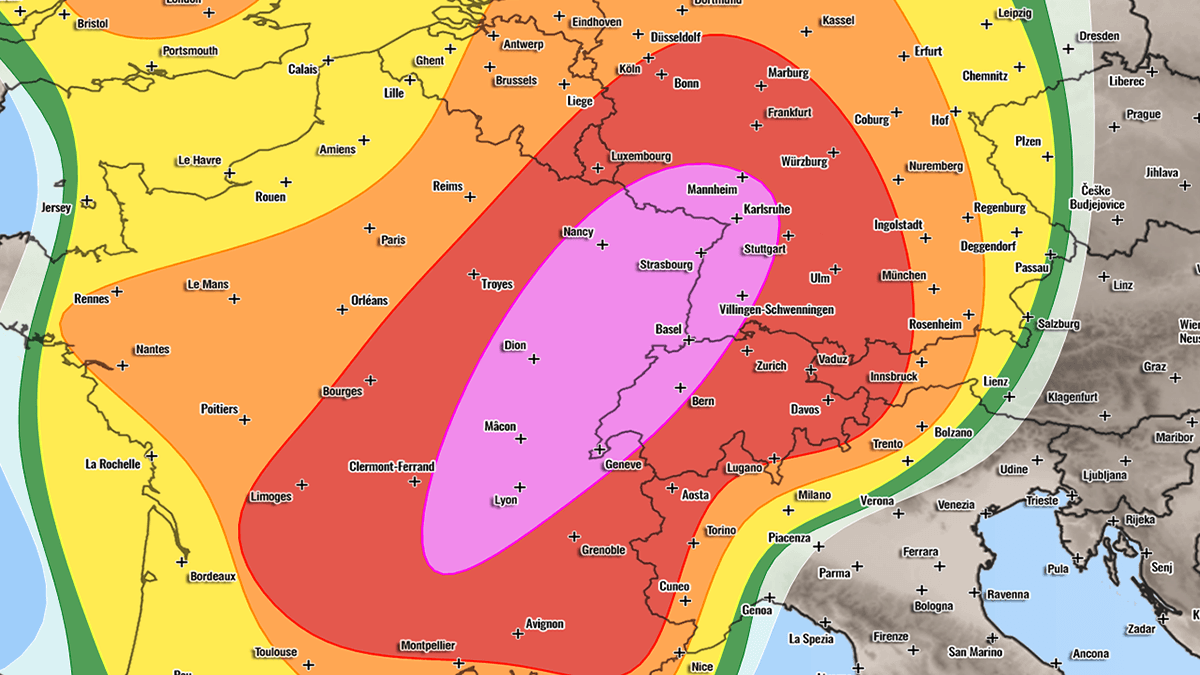
Meteorologists are bracing for a significant, multi-day severe weather outbreak across large swaths of Western and Central Europe. From Thursday, August 27, through Friday night, August 28, 2026, a potent combination of extreme atmospheric instability, high humidity, and powerful wind shear is expected to trigger widespread, violent thunderstorm activity.
The forecast indicates a volatile transition as a deep upper-level trough encounters a persistent, high-pressure ridge over the Mediterranean. This clash of air masses will fuel severe convective storms capable of producing "giant" hail—ranging from 6 to 10 centimeters in diameter—damaging straight-line winds, flash flooding, and, in localized areas, tornadic activity. Authorities in France, Switzerland, Germany, the Czech Republic, and Poland have been placed on high alert as the storm system progresses eastward.
Synoptic Overview: The Mechanics of the Storm
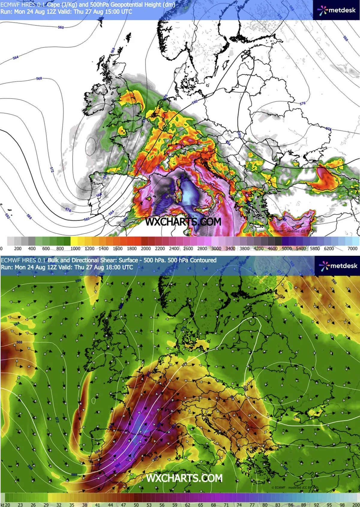
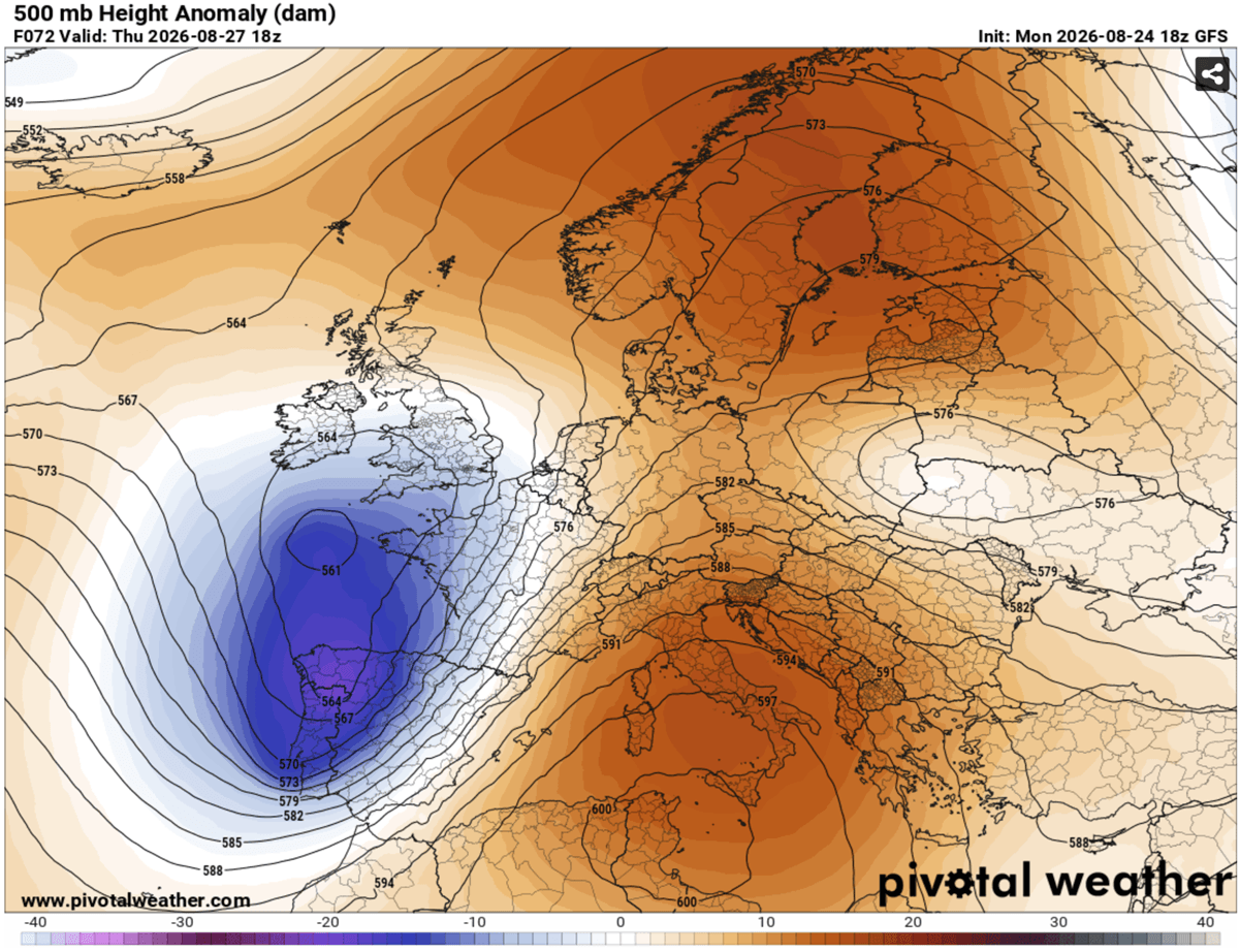
The current meteorological setup over the European continent is characterized by a stark contrast between two massive systems. A deep-trough structure is encroaching upon Western Europe, while a robust blocking High remains anchored over the Mediterranean region.
This configuration has created an intense pressure and temperature gradient. A powerful southwesterly jet stream, originating over eastern Spain and sweeping across the Western Mediterranean, is acting as an engine for the impending weather. As this jet stream moves into the humid air mass over France, it introduces significant wind shear—the change in wind speed and direction with height—which is a critical ingredient for organizing thunderstorms into long-lived, dangerous supercells.
The frontal system associated with this trough is expected to push steadily from west to east. By midday Thursday, the cold front will begin its sweep, providing the necessary forcing to lift the moisture-laden, unstable air, leading to explosive storm development.
Chronology of the Event
Phase I: Thursday, August 27 – The French and Swiss Corridor
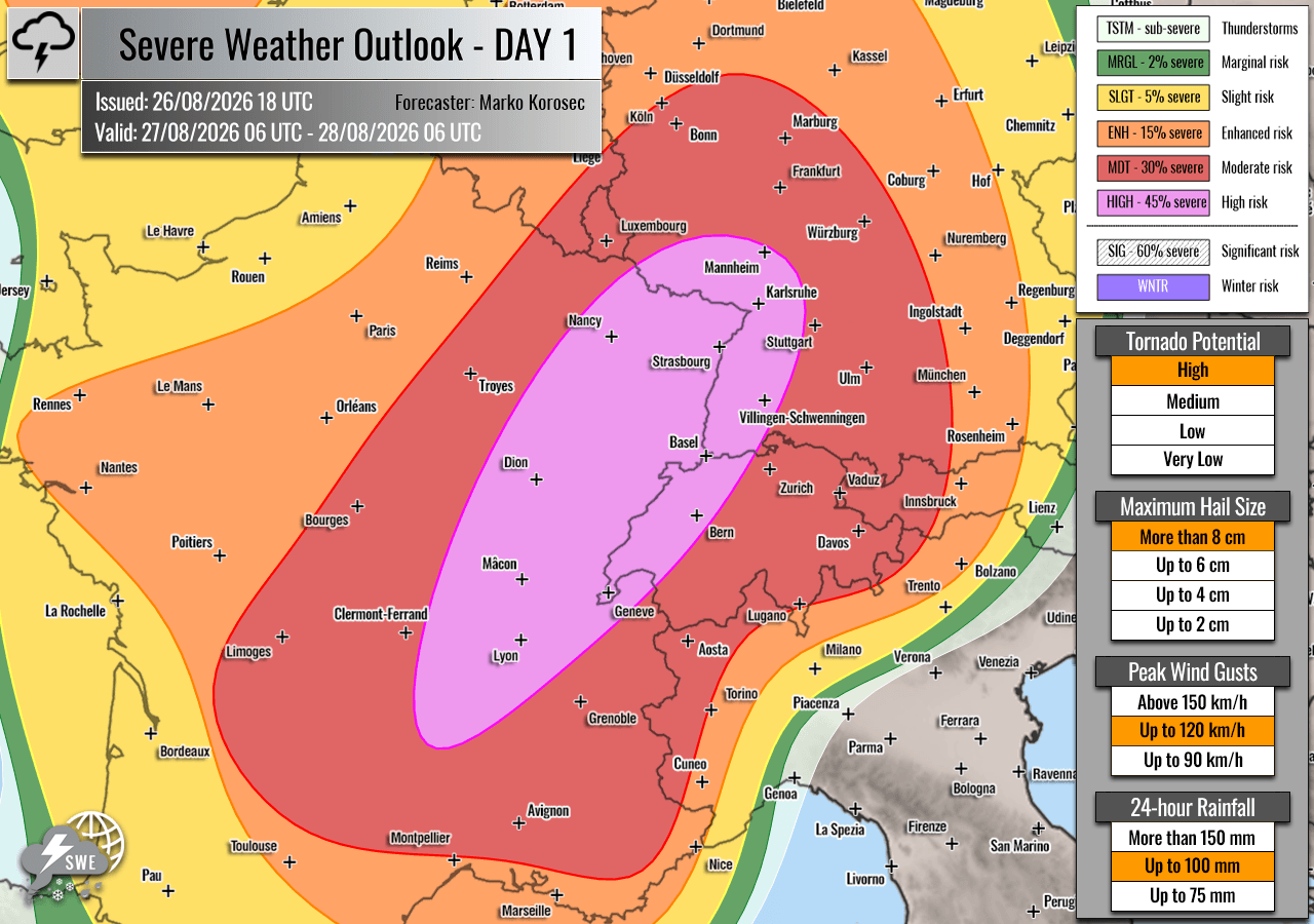
Thursday marks the initial phase of the outbreak, with the highest threat levels concentrated across east-central France, western Switzerland, and southwestern Germany.
Midday to Afternoon:
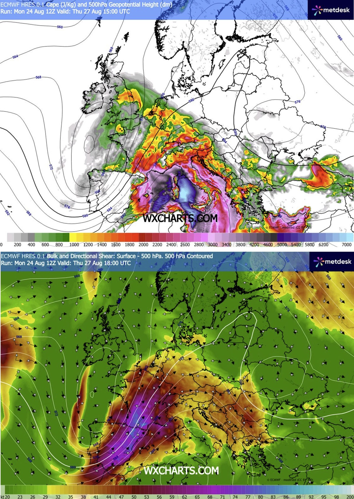
Storm initiation is expected to begin around the Massif Central in France. Southerly winds will pump high dewpoints from the Mediterranean into the region, creating localized extreme instability. MLCAPE (Mixed Layer Convective Available Potential Energy) values are projected to reach between 2,000 and 4,000+ J/kg, providing more than enough fuel for "explosive" convective growth.
Evening and Overnight:
As the system moves east-northeast, the primary threat will shift toward the Rhône Valley. Meteorologists are particularly concerned about the potential for tornadic supercells here, as the low-level wind shear is at its peak. These individual supercells will likely merge into larger convective clusters as they traverse the border into Switzerland and southwestern Germany. These clusters will bring the secondary—but equally dangerous—threat of torrential rainfall and flash flooding, compounded by wind-driven hail.
Phase II: Friday, August 28 – The Alpine and Central European Surge
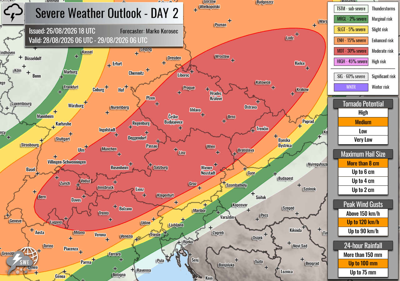
The focus of the severe weather will shift eastward on Friday, impacting the Alpine regions, the Czech Republic, and southwestern Poland.
Morning to Early Afternoon:
Isolated thunderstorms are expected to initiate over the higher elevations of the Alps. These storms will rapidly tap into the remaining instability, quickly evolving from multicell structures into intense, rotating supercells.
Late Afternoon to Evening:
The primary concern for Friday is the potential for a large Mesoscale Convective System (MCS). High-resolution weather models indicate that storms originating in southeastern Germany and northeastern Austria may organize into a cohesive, dangerous line. Should this occur, the bowing segments of the storm system could generate destructive straight-line winds exceeding 120 km/h. As these storms move into the Czech Republic and Poland overnight, the threat of widespread wind damage will become the primary focus for emergency responders.
Supporting Meteorological Data
The intensity of this event is underscored by several key atmospheric indicators:
- Instability (CAPE): Values exceeding 3,000 J/kg in parts of France indicate an environment primed for extreme updrafts, essential for the production of giant hail.
- Wind Shear: The presence of the southwesterly jet stream provides the necessary "tilt" to storm updrafts, allowing them to sustain themselves for longer periods and increase the likelihood of rotation.
- Moisture Profiles: Extreme heat in the Mediterranean has elevated dewpoints, ensuring that the atmosphere is saturated with the energy required to fuel heavy, localized precipitation, which will lead to flash flooding in urban areas.
Implications and Public Safety
The classification of "HIGH" and "MDT" (Moderate) risks serves as a critical warning to residents and local authorities.
Potential Impacts:
- Giant Hail: With hail stones potentially reaching 10 cm, property damage to vehicles, roofs, and glass structures is nearly certain in areas directly impacted by the core of the supercells.
- Flash Flooding: In regions with complex topography, such as the Alps and the Rhône Valley, torrential rain will likely overwhelm drainage systems, leading to sudden, dangerous flooding of roads and low-lying areas.
- Wind Damage: Winds exceeding 120 km/h pose a risk to power grids, telecommunications infrastructure, and mature trees.
- Tornadic Risk: While tornadoes are localized, the current shear profiles in eastern France suggest that residents should have a plan to reach a sturdy interior room if sirens are sounded.
Official Responses and Preparedness
While official government warnings are updated hourly based on real-time radar, meteorologists are urging the public to prioritize personal safety over property protection.
Recommended Preparations:
- Monitor Local Updates: Keep a battery-operated radio or reliable weather app handy, as power outages are a high probability.
- Secure Outdoor Property: Loose items—patio furniture, potted plants, and light structures—should be secured before the arrival of the storm front.
- Avoid Travel: If a "High Risk" alert is issued for your area, avoid all non-essential travel. The combination of torrential rain, low visibility, and potential wind damage makes roads extremely hazardous.
- Stay Indoors: During the peak of the storms, the safest location is the lowest level of a sturdy building, away from windows.
As the system progresses, residents in the affected countries are encouraged to monitor local meteorological services, such as Meteo-France, DWD (Germany), and regional alpine weather agencies, which will be providing real-time data on the track and intensity of individual storm cells.
This weather event serves as a stark reminder of the atmospheric volatility that can occur during late summer. The combination of intense lingering heat and the arrival of cooler, high-momentum air from the Atlantic remains one of the most dangerous patterns for Central and Western Europe. Vigilance remains the best defense against this significant weather threat.