A powerful and rapidly intensifying atmospheric system is currently carving a destructive path across the North Atlantic, threatening Ireland, the United Kingdom, and eventually Iceland with severe windstorms, life-threatening coastal swells, and significant meteorological disruption. Meteorologists have officially classified this system as a "bomb cyclone," a rare and volatile weather phenomenon defined by a rapid drop in central barometric pressure that signifies a sudden, violent maturation of a storm.
The Dynamics of Bombogenesis
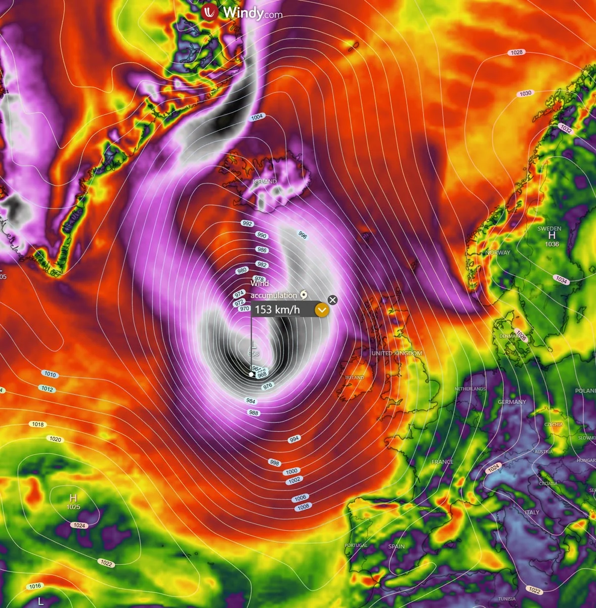
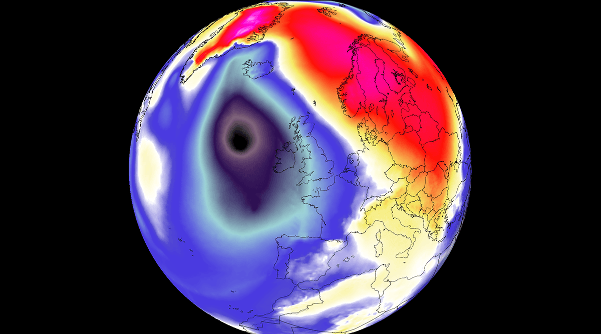
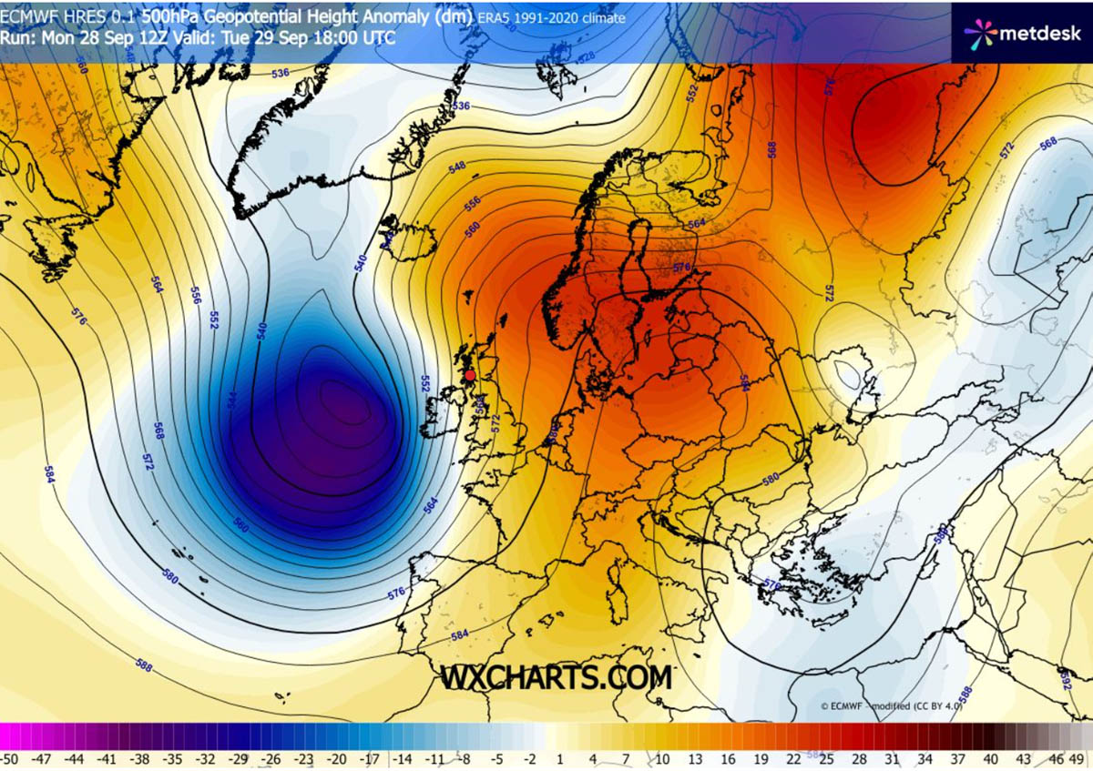
The explosive development of this storm is the result of a high-amplitude upper-level trough swinging out of the North Atlantic. This cold-core feature is colliding with a massive 1035 hPa blocking high-pressure system currently anchored over Central Europe and Scandinavia. This interaction creates a exceptionally steep baroclinic gradient—a region where temperatures and pressures shift dramatically over short distances.
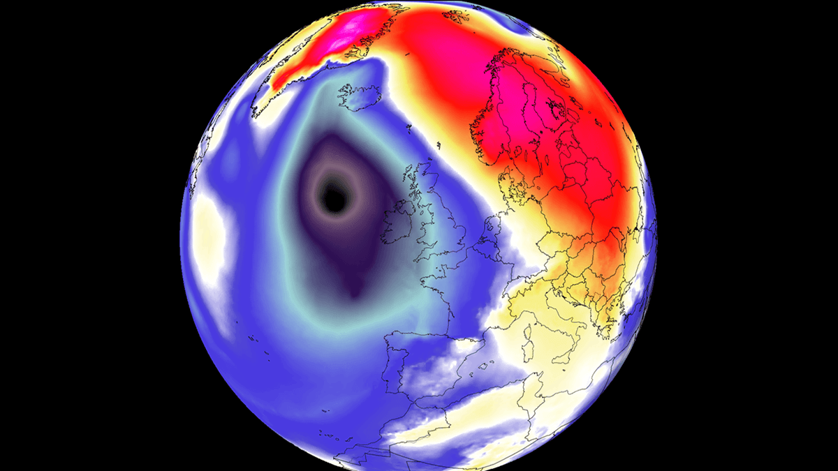
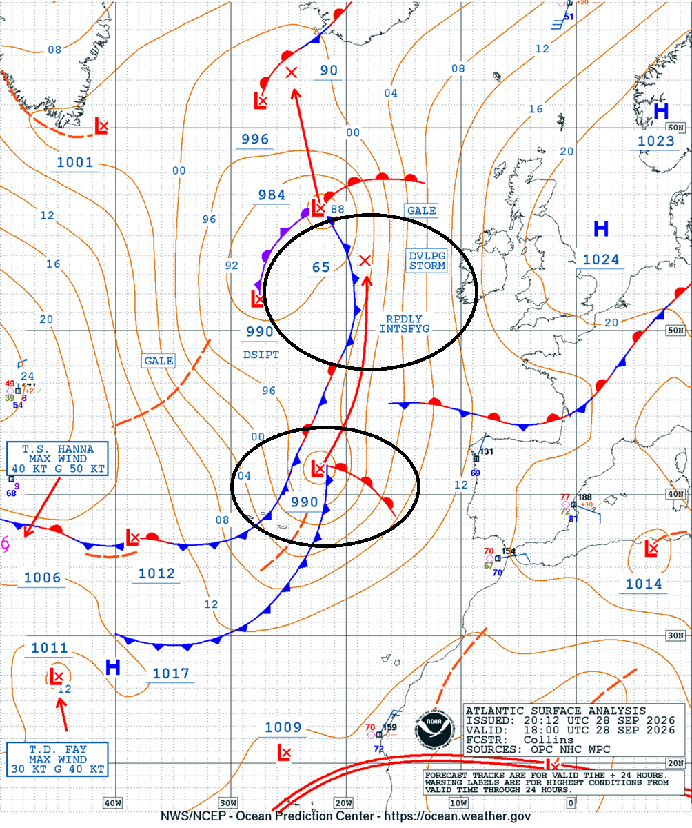
This gradient acts like a pressure cooker, squeezing the isobars (lines of equal pressure) across the UK and Ireland. The resulting pressure differential is the engine driving the storm’s severe gale-to-storm-force winds. In meteorological terms, a "bomb cyclone" occurs when the central pressure of a mid-latitude system drops by at least 24 millibars within a 24-hour period. Current models indicate that this system is exceeding that threshold with ease, as pressure plummets from roughly 990 mbar on Monday evening to a projected 950 mbar or lower by Wednesday, marking it as a significant, high-impact event.
Chronology of the Storm’s Evolution
Monday: The Initial Development
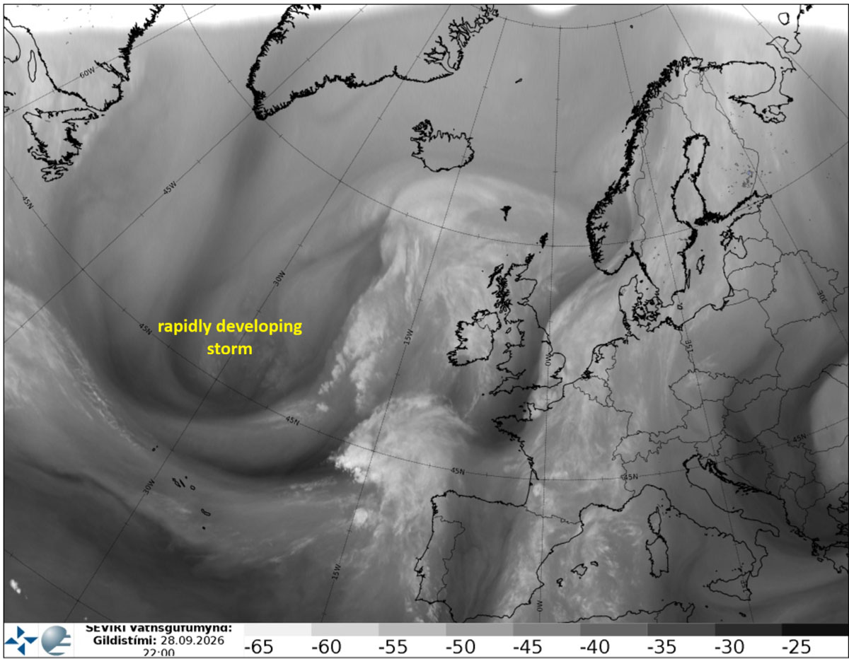
Satellite imagery captured the early warning signs of the developing system on Monday night. Water vapor imagery revealed a sharp baroclinic zone and a tightening jet stream, providing the kinetic energy required for the system to "bomb out." By late Monday, the Ocean Prediction Center (OPC) had already identified a core wave emerging west of the Iberian Peninsula, tracking northward and organizing into a cohesive, dangerous cyclone.
Tuesday: Impact on Ireland and the UK
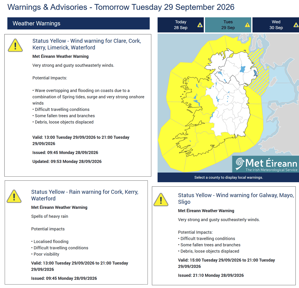
As the storm approaches the western fringes of Europe on Tuesday, the most immediate impacts are being felt across coastal Ireland, Northern Ireland, and parts of Scotland. Met Éireann, the Irish meteorological service, has issued yellow weather warnings for coastal regions, anticipating gusty southeasterly winds. These winds are not merely uncomfortable; they are capable of creating hazardous driving conditions, felling trees, and causing localized power outages and flooding.
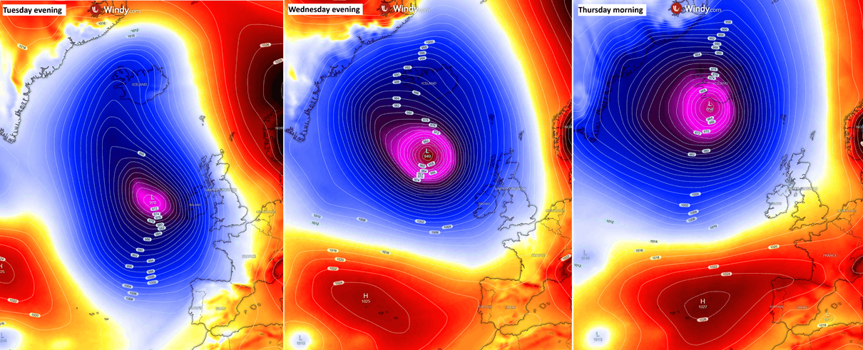
By Tuesday evening, the system is expected to position itself to the west of the UK, with its massive circulation bringing peak wind gusts of 100 to 130 km/h to Ireland, Northern Ireland, and the western reaches of England and Scotland. The sheer size of this circulation means that while the storm’s center remains offshore, its influence will be felt across a massive swath of Western Europe.
Wednesday: Peak Intensity and the Shift North
As the cyclone continues its northward trek, it is forecast to reach its peak intensity on Wednesday. Central pressure is expected to dip below 950 mbar, with some models suggesting a reading as low as 945 mbar as it passes to the west of the Faroe Islands. During this phase, the pressure gradient surrounding the low-pressure core will be at its most extreme, potentially generating near-hurricane-force winds in the immediate vicinity of the storm’s center.
Thursday: Arrival in Iceland
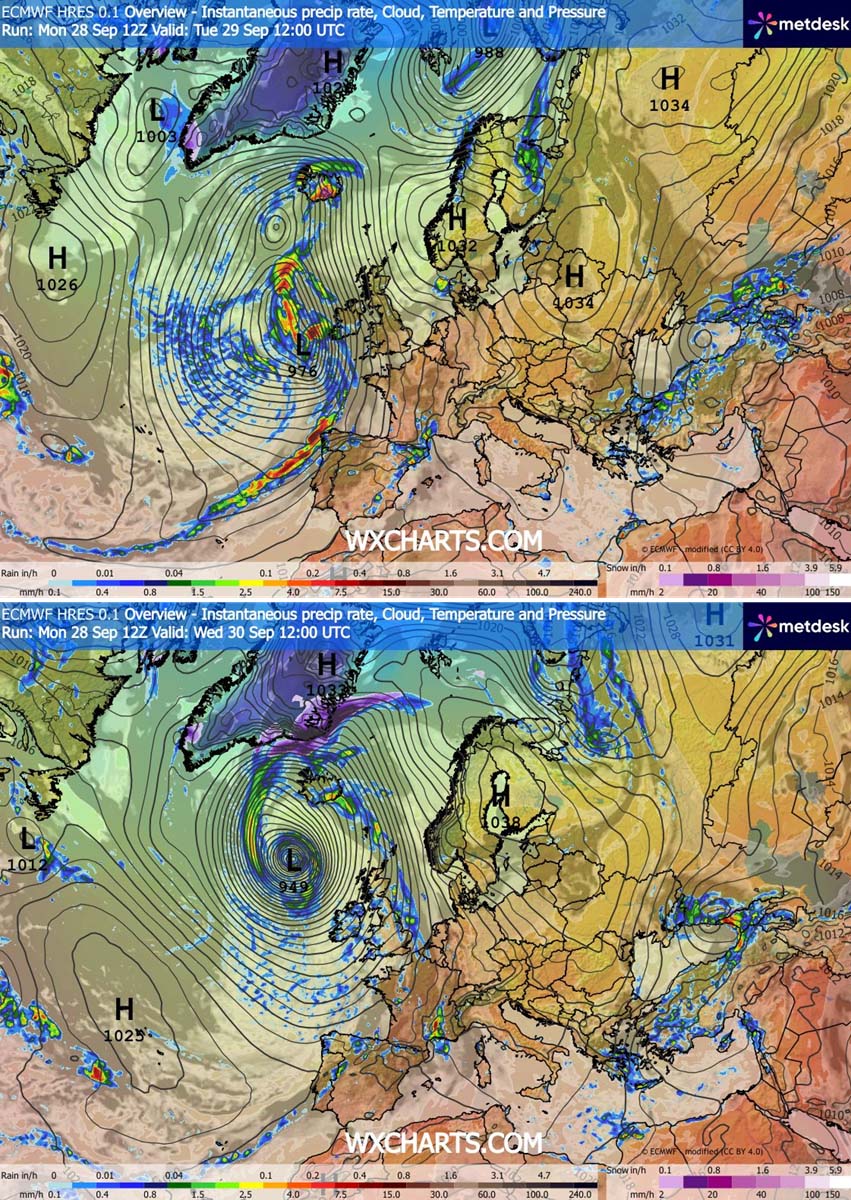
By Thursday morning, the storm will move ashore in Iceland. While the system may begin a slow, marginal weakening phase by this point, it will still retain significant power. The focus of the storm will then shift from wind-related damage to extreme, persistent rainfall, particularly for the southern and southeastern regions of Iceland, which will face the brunt of the moisture-laden atmospheric river associated with the storm.
Supporting Data and Meteorological Analysis
Pressure and Wind Swaths
The pressure analysis is clear: this is a major synoptic event. The transition from a 990 mbar system to a sub-950 mbar monster in under 48 hours is a testament to the energy present in the North Atlantic current. Wind-gust swath models consistently show a concentrated area of extreme winds following the path of the center. In the most exposed areas—specifically the Irish western coast and the Outer Hebrides—wind speeds are expected to surpass 150 km/h at the peak of the storm’s life cycle.
The Coastal Threat: 12-Meter Swells
Beyond the wind, the storm is generating a massive wave field. Because of the size and intensity of the wind field rotating around the center, the Atlantic Ocean will produce significant wave heights. Projections indicate swells reaching 10 to 12 meters in the open waters west of Ireland and Scotland. For those living along the Atlantic-facing shores, waves of 8 to 10 meters are expected, posing a severe risk of coastal flooding and erosion. Maritime authorities have issued stern warnings for all shipping vessels to avoid the affected quadrants of the North Atlantic.
Thermal Anomalies
The storm is also acting as a massive heat pump. The circulation is pulling a plume of unseasonably warm air from lower latitudes and pushing it rapidly northward. This will result in significant positive temperature anomalies across Northwestern Europe, the Faroe Islands, and Scandinavia. While this may provide a temporary "warmth" to the region, it is a byproduct of the storm’s violent circulation and will likely be accompanied by heavy rain bands as the warm, moist air is forced over cooler northern landmasses.
Official Responses and Public Safety
Met Éireann and other national weather agencies in the UK and Iceland have urged the public to monitor local forecasts as the storm progresses. The primary dangers cited include:
- Transport Disruption: High-sided vehicles are at risk on exposed bridges and motorways due to the intense squall lines.
- Coastal Hazards: Extreme wave heights and potential storm surges may make coastal roads and promenades hazardous.
- Infrastructure Damage: The intensity of the wind gusts is sufficient to cause structural damage to roofs, power lines, and trees, which may lead to widespread, if localized, power interruptions.
Local authorities in Ireland have advised residents to secure loose outdoor items and stay clear of beaches and cliffs, where the combination of high winds and massive swells creates a high risk for accidents. In Iceland, the forecast for extreme rainfall—locally reaching 250–300 mm—has triggered concerns about flash flooding and debris flows, particularly in mountainous, orographically sensitive regions.
Broader Implications and Context
This storm occurs within a broader, complex climate context. Meteorological data suggests that the North Atlantic has been particularly active, and the development of such a deep, powerful cyclone in September highlights the transition into the autumn storm season.
Furthermore, this event serves as a reminder of the "Omega blocking" pattern currently dominating the European weather scene. The high-pressure system sitting over Central Europe is effectively acting as a wall, forcing the Atlantic depression to take a more northern track toward Iceland rather than moving east across the heart of the continent.
As the world continues to observe shifting weather patterns, the formation of such a robust bomb cyclone in the 2026 season reinforces the need for accurate, real-time meteorological monitoring. The combination of high-resolution satellite imagery from the water vapor spectrum and advanced numerical weather prediction models allows for the timely issuance of warnings that are critical to mitigating the impact on human life and infrastructure.
The situation remains fluid. Residents in the path of the storm are encouraged to consult official sources such as Windy, Vedur IS, and national weather services for the most current updates as the system tracks toward its final destination. As the storm moves toward Iceland on Thursday, the focus will undoubtedly shift toward the aftermath and the assessment of the damage wrought by this violent, rapidly developing piece of Atlantic weather.
For now, the advice remains consistent: stay alert, stay indoors during the peak of the squall lines, and respect the power of the sea during this significant meteorological event.