By Meteorological Desk | July 25, 2026
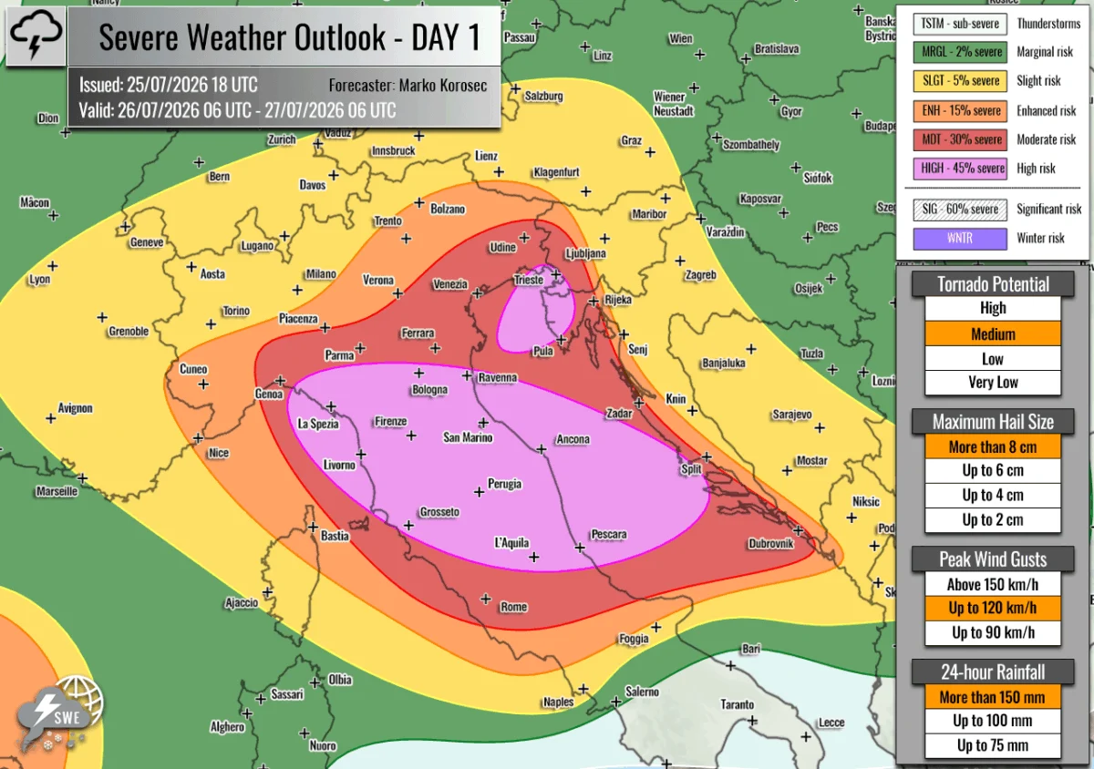
A significant and potentially life-threatening severe weather outbreak is poised to strike the north-central Mediterranean and the Adriatic Sea region this Sunday, July 26, 2026. Meteorologists at Severe Weather Europe, led by forecaster Marko Korošec, have issued urgent warnings as a combination of extreme atmospheric instability, moisture-laden air masses, and intense wind shear converge to create the conditions for a major convective event.
The forecast, valid from 06:00 UTC on July 26 to 06:00 UTC on July 27, highlights a dangerous environment capable of producing giant hail—potentially exceeding 10 centimeters in diameter—damaging wind gusts, violent tornadoes, and catastrophic flash flooding.
The Synoptic Overview: A Volatile Atmospheric Setup
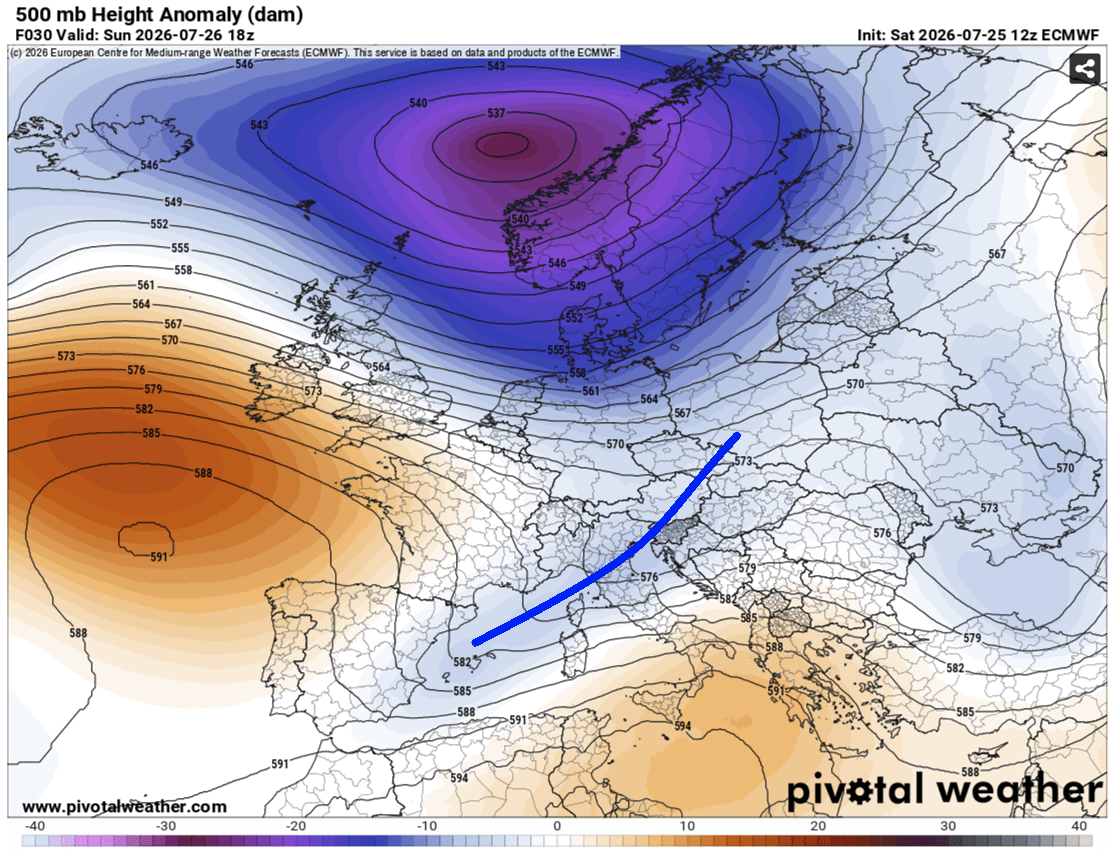
The current weather pattern across Europe is defined by a deep, nearly stationary upper-level low-pressure system positioned over Northern Europe. This system is effectively "locked" between two robust high-pressure ridges: one dominating the North Atlantic and another exerting influence over Russia.
As this blocking pattern persists, a secondary, potent wave of energy is tracking across Central Europe toward the east. This movement is triggering a classic, highly volatile setup for the northern Mediterranean. At the surface, a deep low-pressure system has formed near western Norway, with a secondary, responsive low-pressure center developing over the Mediterranean basin.
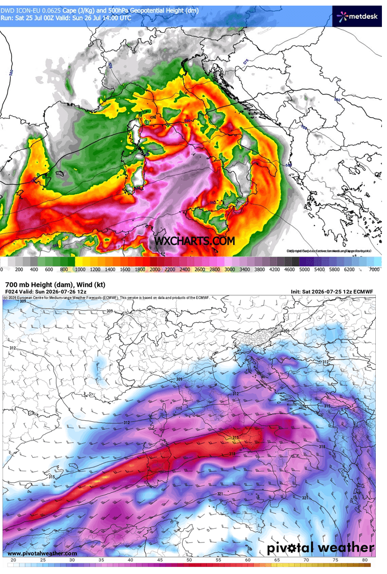
This configuration is driving a powerful cold front across the Alps, sweeping from west to east into the northern Mediterranean, the Adriatic Sea, and the Western Balkans. Ahead of this front, intense south-westerly winds are advecting massive amounts of moisture from the central Mediterranean into the northern regions. Given the backdrop of an ongoing, extreme summer heatwave, the atmosphere is primed with high dewpoints, leading to "extreme" instability levels, with MLCAPE (Mixed-Layer Convective Available Potential Energy) values expected to reach between 2,000 and 3,000+ J/kg over the Tyrrhenian and Adriatic Seas.
Chronology of the Outbreak
The progression of this weather event is expected to be rapid, beginning in the early hours of Sunday morning.
Morning: The Ligurian Spark
The event is expected to initiate over the Ligurian Bay during the early morning hours. As the upper-level wave begins its transition over the Alps toward the Mediterranean, moisture will be forced into the complex terrain of the Apennine Mountains. Forecasters anticipate the explosive development of multicell thunderstorm clusters and discrete supercells.
Afternoon: Intensification and Eastward Propagation
By midday, the storm activity will intensify significantly as it pushes toward the Adriatic Sea. The "left-exit" region of a powerful mid-level jet stream will provide the necessary lift to sustain these storms. The combination of intense wind shear—the change in wind speed and direction with height—and high instability will likely result in the rapid evolution of these cells into highly organized, severe weather systems.
Evening to Overnight: The Adriatic Corridor
The focus will shift to the North Adriatic by late afternoon and evening. Stationary convergence zones are expected to form along the nose of a low-level jet, trapping storm systems over specific coastal areas. The primary risk here is excessive, prolonged rainfall. High-resolution meteorological models suggest that certain regions could see rainfall totals of 100–200 mm within a 6 to 12-hour window. This is particularly alarming given the height of the summer tourist season, which has left coastal areas in Istria and northwestern Croatia densely populated.
Supporting Meteorological Data
The severity of this event is underscored by several critical meteorological indicators:
- Extreme Instability (CAPE): With values exceeding 3,000 J/kg, the atmosphere contains massive amounts of energy available to fuel vertical storm growth.
- High Precipitable Water (PWAT): Values ranging from 45–60 mm indicate a very "wet" atmosphere, which acts as the fuel for the torrential rainfall and flash flooding potential.
- Wind Shear and Helicity: The presence of a strong mid-level jet stream, coupled with low-level shear, provides the "spin" necessary for the formation of tornadic supercells. The highest tornado risk is currently identified in central Italy and along the northern Adriatic coastline.
- Storm Mode: The forecast models indicate that the initial discrete supercells will eventually merge into larger, more expansive convective systems, increasing the footprint of the damaging wind and hail threats.
Regional Risk Assessment and Implications
Severe Weather Europe has categorized the risk into distinct zones to help emergency management and local populations prepare for the incoming threat.
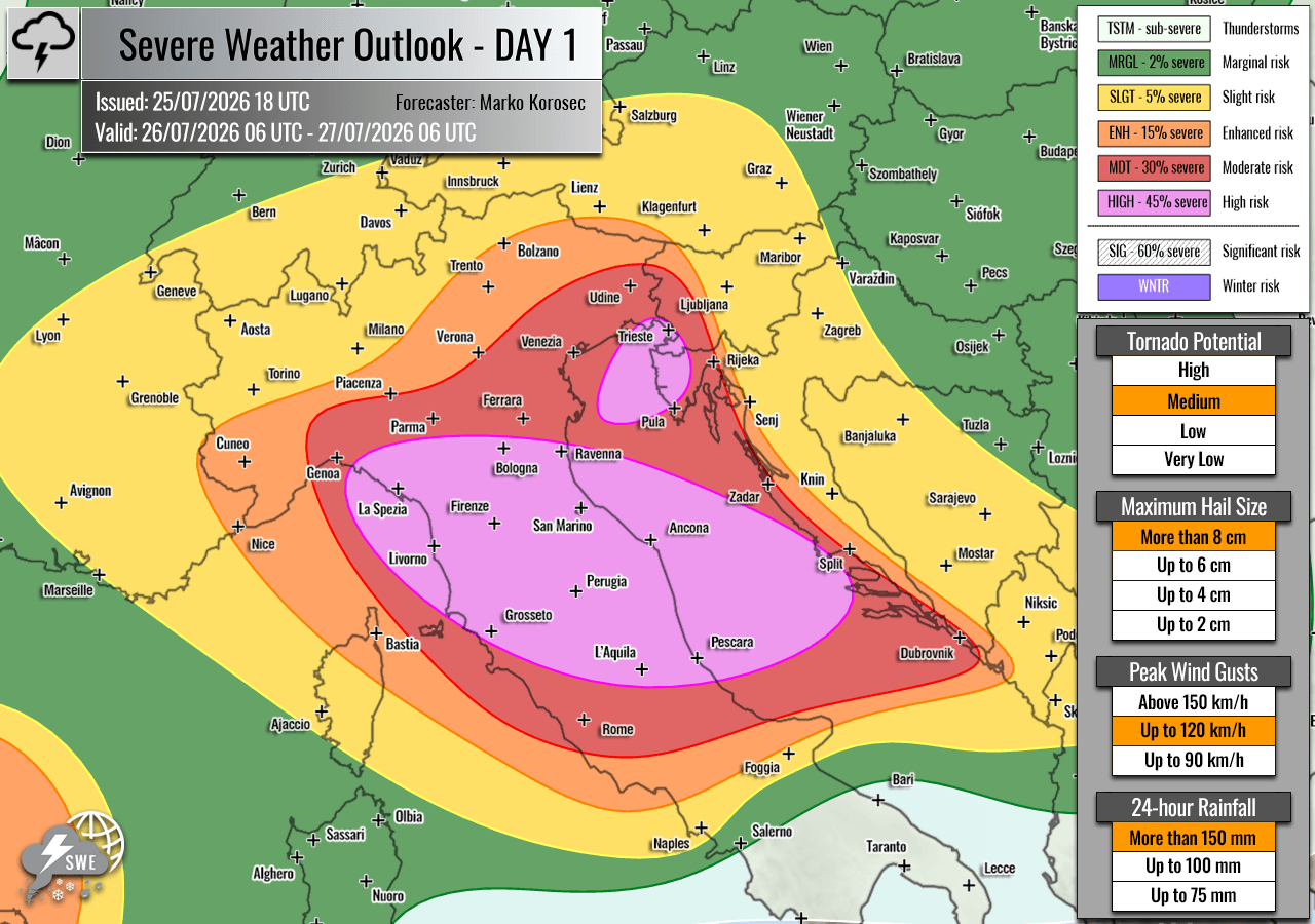
The HIGH Risk Zones
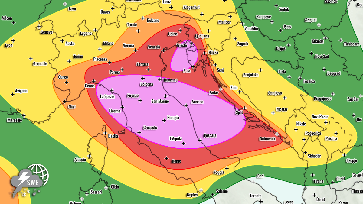
A HIGH risk designation has been issued for central and northern Italy, extending into the central Adriatic. Residents in these areas should prepare for giant hail (6–10+ cm), destructive wind gusts, and severe flooding. A second HIGH risk area covers the northeast Adriatic, including the Istrian Peninsula of Croatia and southwestern Slovenia. Here, the threat is dominated by the potential for life-threatening flash floods and damaging winds.
The MDT/ENH/SLGT Risk Areas
Surrounding the high-risk zones, MDT (Moderate) and ENH (Enhanced) risks cover portions of western and central Slovenia, western and central Croatia, west-central Austria, and southern Switzerland. While the coverage of storms may be slightly lower than in the high-risk zones, the potential for severe weather remains significant.
International Considerations
The impact of this weather system is not limited to the Mediterranean. An ENH risk has been issued for the Balearic Islands and northeastern Spain, where isolated but intense supercells are expected to develop. Additionally, a SLGT (Slight) risk extends across the Netherlands, northern Germany, and Poland, as the trailing edge of the upper-level wave brings a threat of damaging winds and marginal hail. Finally, a significant ENH/SLGT risk has been issued for southwestern Russia, where high instability and shear are expected to produce organized supercells capable of tornadoes, large hail, and destructive winds.
Public Safety and Preparedness
The implications of this forecast are severe. Local authorities and emergency services in the affected regions are urged to maintain high vigilance.
Key safety considerations include:
- Flash Flooding: Because many of the areas at risk are characterized by complex terrain or high tourist density, flash flooding poses a significant risk to life and infrastructure. Low-lying areas and dry riverbeds should be avoided.
- Wind and Hail: Property owners are advised to secure loose outdoor items that could become projectiles in high winds. The potential for "giant" hail necessitates moving vehicles under cover if possible.
- Tornado Awareness: Residents should monitor local weather alerts closely. If a warning is issued, moving to the lowest, most interior level of a sturdy building is the safest course of action.
- Travel: Travelers in the Adriatic and Mediterranean regions should expect significant disruptions to transportation, including ferries, flights, and road travel, as the storm front moves through.
This event is a stark reminder of the volatile nature of the Mediterranean climate during the peak of summer. The combination of intense heat and the arrival of a significant upper-level disturbance creates a "perfect storm" scenario. Residents and visitors alike are encouraged to follow local meteorological agencies and emergency broadcasts for real-time updates as the situation evolves throughout the day on Sunday.
This report is based on current meteorological data provided by Severe Weather Europe, with data support from Wxcharts, PivotalWeather, and Meteoadriatic.