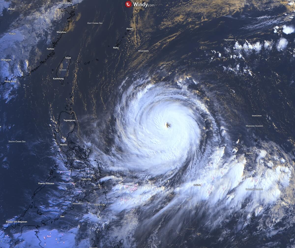
The Western Pacific has been thrust into a state of high alert as Super Typhoon Bavi—a meteorological powerhouse of unprecedented volatility—continues its relentless march across the Philippine Sea. In a display of rapid intensification that has stunned weather experts, Bavi has evolved from a modest tropical disturbance into a Category 5-equivalent monster in less than 48 hours. With sustained winds reaching a staggering 180 mph and a central pressure plummeting to 901 mbar, Bavi is currently ranked as one of the most violent and rapidly escalating storms of the season.
The Anatomy of an Atmospheric Monster
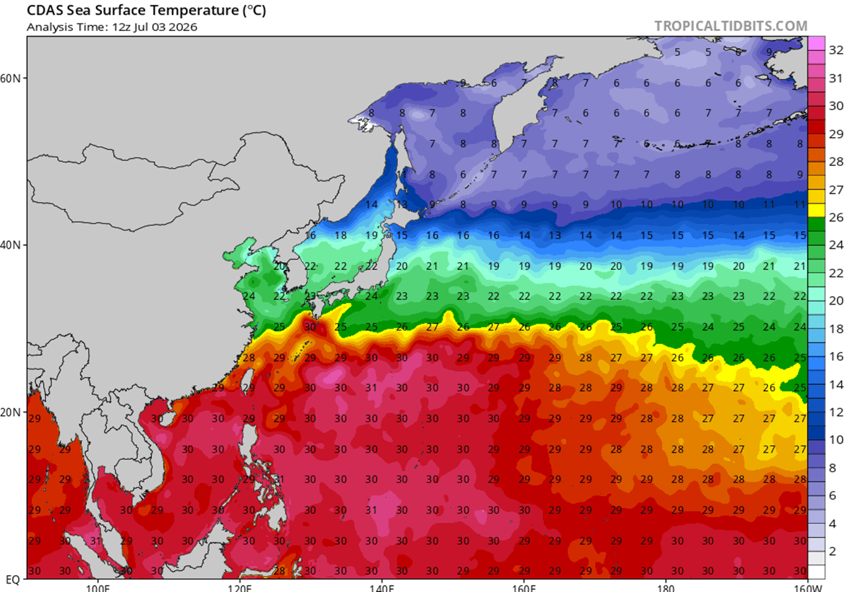
The rapid development of Bavi is a textbook, albeit extreme, example of what happens when a tropical cyclone encounters near-perfect environmental conditions. Fueling this explosive growth are oceanic temperatures in the Western Pacific that have soared to between 29°C and 32°C (84°F–90°F). These temperatures, which are roughly 2°C to 3°C above the seasonal average, provide a massive reservoir of latent heat—the "fuel" for any tropical system.

When combined with negligible vertical wind shear, the storm has been able to develop a near-perfect atmospheric outflow, effectively venting its "exhaust" and allowing the core to deepen at an accelerated rate. Following a classic eyewall replacement cycle, the storm did not dissipate or weaken; instead, it emerged from the process larger, more structurally sound, and possessing a significantly wider field of destructive winds. This "buzzsaw" rotation is now bearing down on the region with the force of a major natural disaster.
Chronology of Destruction: From Guam to the Philippine Sea
The initial toll of Bavi’s wrath was felt in the Northern Mariana Islands. The storm’s northern eyewall made a direct, punishing pass over the island of Rota, where residents endured catastrophic hurricane-force winds and torrential, blinding rain. The infrastructure on the island sustained significant damage, a grim testament to the storm’s intensity.
In neighboring Guam, the effects were equally harrowing. While the island was spared the direct impact of the eye, it was battered by sustained, violent gusts reaching 85 mph. Rainfall totals were staggering, with more than 20 inches of precipitation dumped on the island in a short window, leading to widespread flooding and the disruption of critical services.
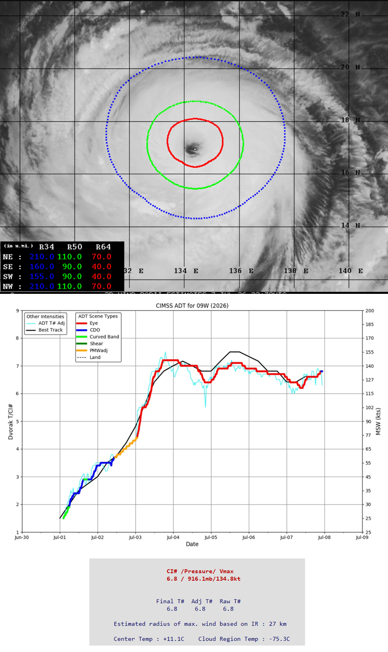
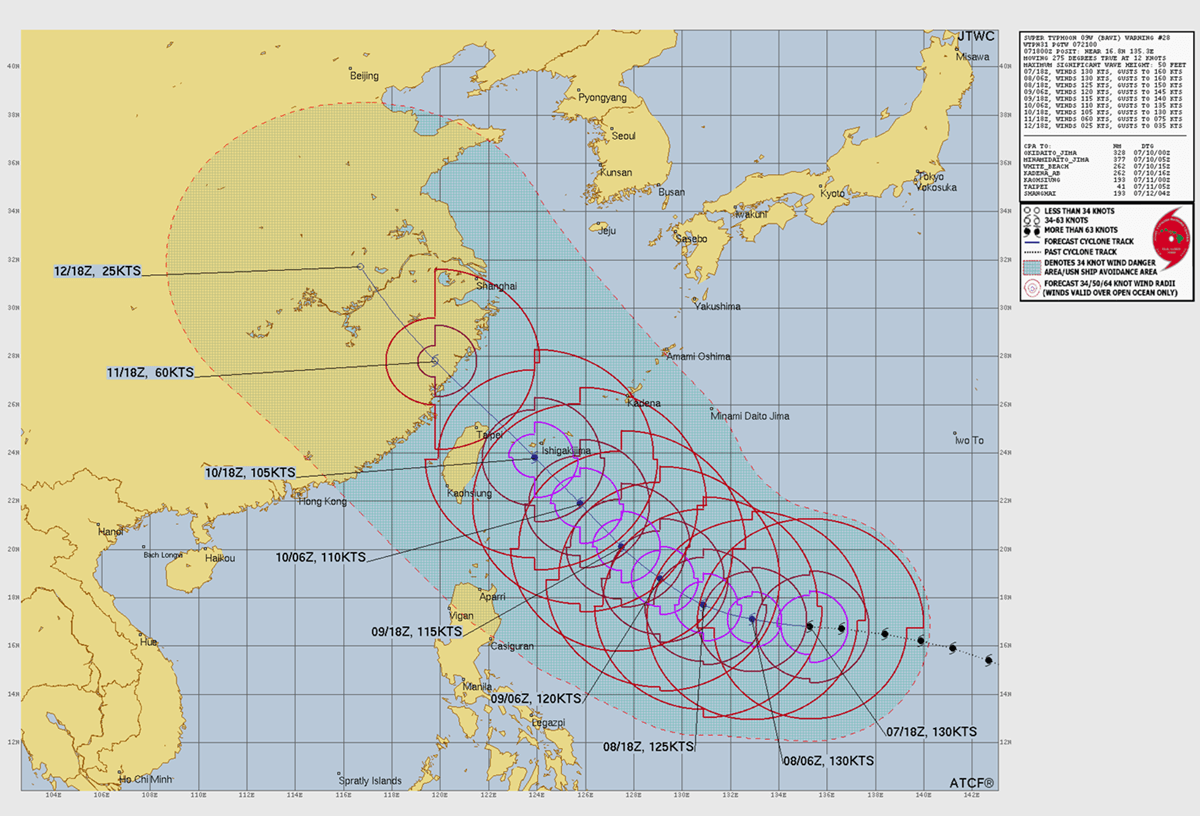
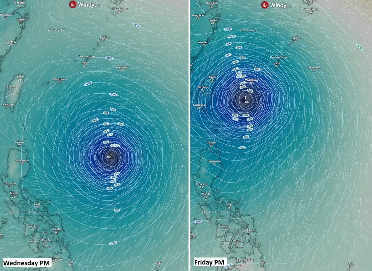
Currently, Bavi maintains a westward track, feeding off the high-energy environment of the Philippine Sea. Satellite analysis, including Advanced Dvorak intensity estimates, confirms that the storm remains at a violent, high-end intensity. Meteorological models project that the system will maintain this lethal strength as it approaches northern Taiwan on Friday, setting the stage for what officials fear will be a historic weather event.
Historical Context: "Typhoon Alley" and the Concrete Island
Guam’s vulnerability is well-documented; it sits squarely in the path of what is colloquially known as "Typhoon Alley." The island has a long, scarred history of dealing with these behemoths. From Typhoon Karen in 1962—which fundamentally changed the island’s architectural standards—to the destructive passages of Paka and Pongsona, the people of the Marianas have learned to respect the raw power of the Pacific.
The legacy of Typhoon Karen cannot be overstated. Prior to 1962, the majority of homes on the island were constructed of wood. The utter devastation wrought by that storm forced a total paradigm shift, leading to the adoption of rigid, modern building codes. Today, Guam is essentially a "concrete island," with homes and commercial buildings designed to withstand the crushing wind loads of a Category 5 cyclone. This foresight has undoubtedly saved countless lives during events like Bavi, though no amount of concrete can fully mitigate the risk of massive storm surges and inland flooding.
Meteorological Data and Predictive Analysis
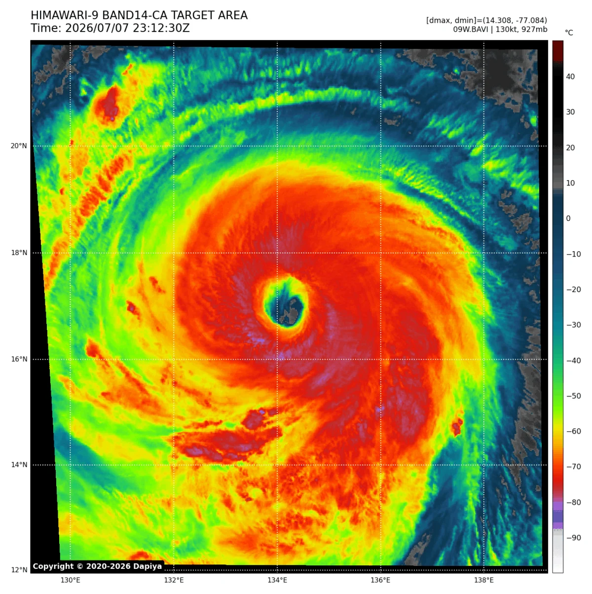
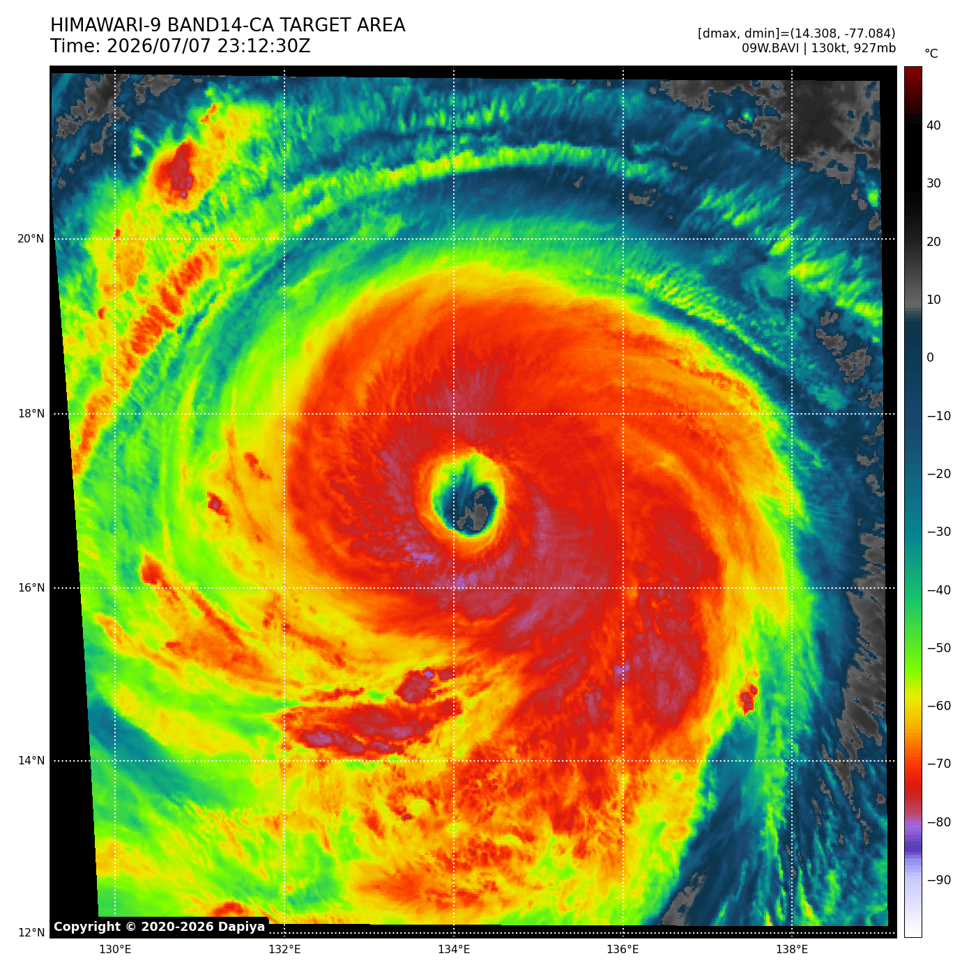
The current satellite imagery presents a chilling picture. The central pressure, estimated at 916 mbar, suggests a storm that is still breathing deeply from the warm ocean waters. The wind field is impressively symmetrical, with tropical-storm-force winds extending up to 110 miles from the center, while the most intense, destructive winds are concentrated within a 60–70 mile radius of the eye.
The infrared and visible satellite animations show a cloud structure that is both massive and well-defined, with a clear, deep eye that signals a highly organized system. Current model guidance indicates that while Bavi may undergo minor intensity fluctuations as it executes further eyewall replacement cycles, it is expected to remain a high-end Category 4 or Category 5 storm until it begins to interact with the cooler waters and higher wind shear near the coast of China and the mainland.
Regional Implications: A Multi-Front Crisis
As Bavi pivots toward northern Taiwan and the southern Japanese islands, the threat profile changes from wind damage to systemic flooding.
Rainfall and Flash Flooding
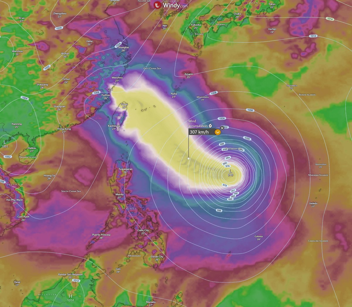
While the storm’s most intense wind core may narrowly miss the mainland of Taiwan, the rainfall accumulation will be record-breaking. Meteorologists are predicting 600 to 1,000 mm (up to 40 inches) of rain in the mountainous regions of Taiwan over a 48-hour period. Given the steep topography of the island, this volume of water is almost certain to trigger catastrophic flash floods and landslides, threatening rural villages and infrastructure.
Storm Surge and Coastal Impacts
The Japanese islands of Ishigaki and Miyakojima are in the direct path of the storm’s periphery. Residents there are being warned of extreme coastal inundation. When a storm of this magnitude moves through shallow waters, it acts as a pump, forcing massive volumes of seawater inland. Coupled with giant, storm-driven waves, the coastal impact is expected to be extreme, with the potential for long-term power outages and the destruction of harbor facilities.
Official Responses and Public Safety Measures
Governments across the region have initiated emergency protocols. In Taiwan, disaster management agencies have begun pre-positioning rescue assets, including boats, heavy machinery, and emergency medical teams. Public schools and government offices are expected to close, and evacuations have been recommended for residents in high-risk, low-lying areas.
"This is not a storm to be taken lightly," stated a representative from the regional meteorological bureau. "Even if the eye stays offshore, the sheer size of Bavi means that its outer bands will bring sustained, violent conditions that can tear apart roofs, uproot trees, and turn loose objects into lethal projectiles."
Citizens are being urged to:
- Secure Property: Ensure all outdoor items are brought inside and shutters or storm boards are deployed.
- Stockpile Essentials: Maintain at least 72 hours of water, non-perishable food, and medical supplies.
- Monitor Updates: Rely solely on official government weather channels and national news outlets for the latest track information, as the storm’s path can shift unexpectedly.
The Climate Connection: Why the Seas are Boiling
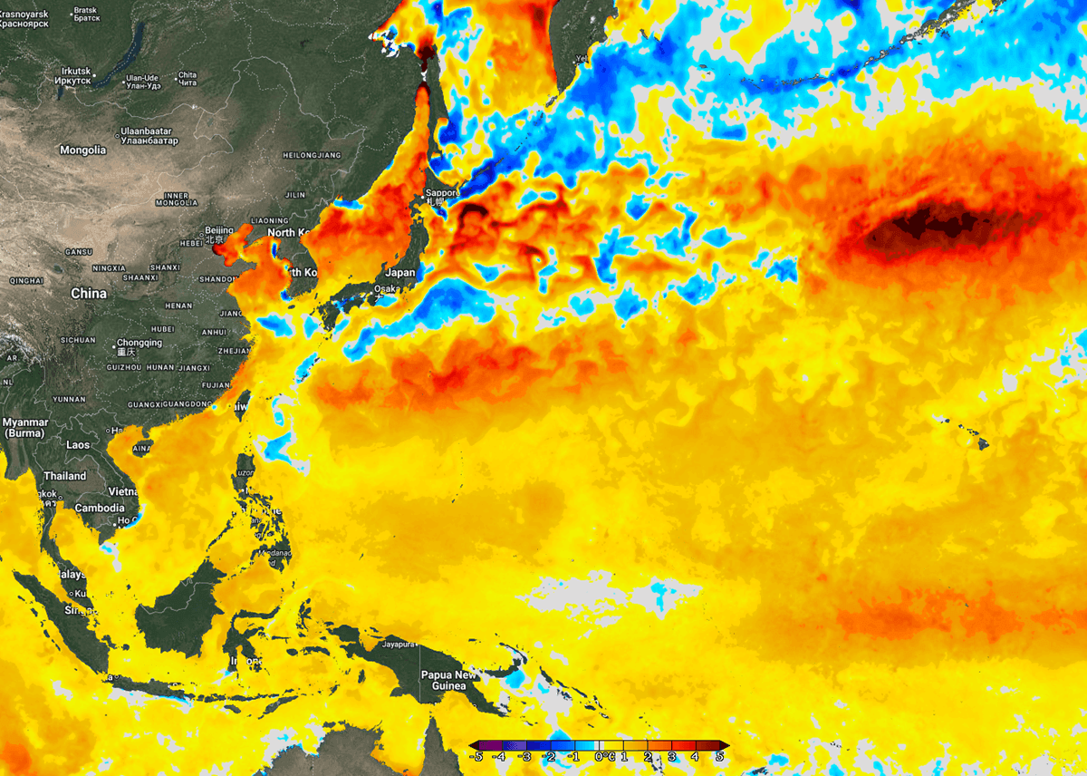
The unprecedented strength of Bavi has reignited discussions regarding the warming of the global oceans. Sea surface temperatures along the coasts of China, Taiwan, and Japan are currently 4°C above the long-term average for this time of year. This anomalous heat is not just a localized event; it is part of a broader trend of ocean heat content rising, which directly correlates to the increasing frequency of "rapid intensification" events in tropical cyclones.
When a storm moves into an environment where the energy density is this high, it ceases to be a simple weather system and becomes a thermodynamic engine. The storm feeds on the thermal energy, converting it into rotational kinetic energy. As long as the waters remain this warm, the risk of "Super" typhoons will continue to rise, placing coastal communities in the Western Pacific on the front lines of a changing climate.
Conclusion: The Path Ahead
As Super Typhoon Bavi continues its journey, the world watches with anxiety. By Saturday, the storm will likely begin a gradual weakening phase as it encounters the more hostile conditions of the China coast. However, the legacy of this storm will be felt long after the winds die down. The destruction caused by Bavi serves as a stark reminder of the immense power of the natural world and the critical importance of robust disaster preparedness. For the millions in the path of this titan, the next 48 to 72 hours will be a test of resilience, planning, and the durability of the infrastructure they call home.
The immediate priority remains the safety of human life. As Bavi reaches its peak, the vigilance of the public and the coordination of emergency services will be the only things standing between a major natural disaster and a humanitarian crisis.