The global climate system is currently undergoing a dramatic transformation as two of the world’s most powerful atmospheric drivers align. A rapidly strengthening "Super El Niño" in the tropical Pacific is now being compounded by the emergence of a positive Indian Ocean Dipole (IOD). This rare synchronization of oceanic anomalies is creating a "dual-ocean atmospheric engine" that climate experts expect will dictate weather patterns, jet stream configurations, and snowfall trends across the Northern Hemisphere for the Winter 2026/2027 season.

Main Facts: The Emergence of a Synchronized Climate Engine
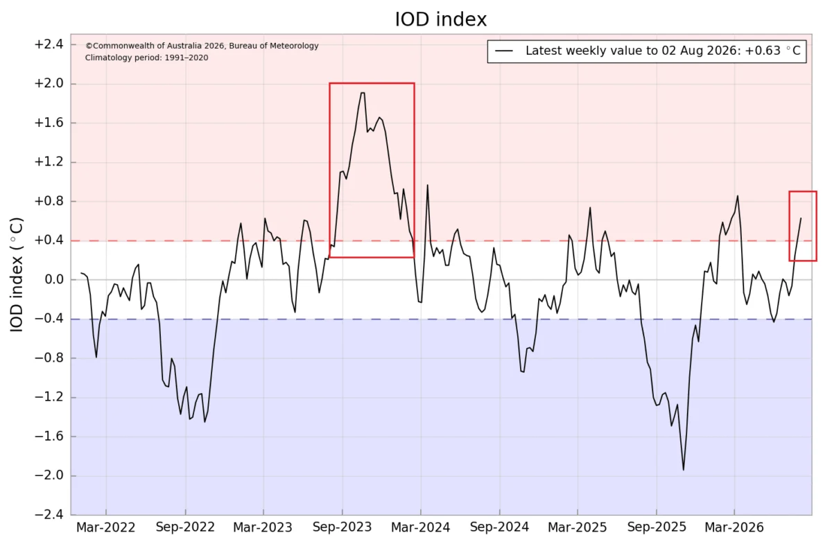
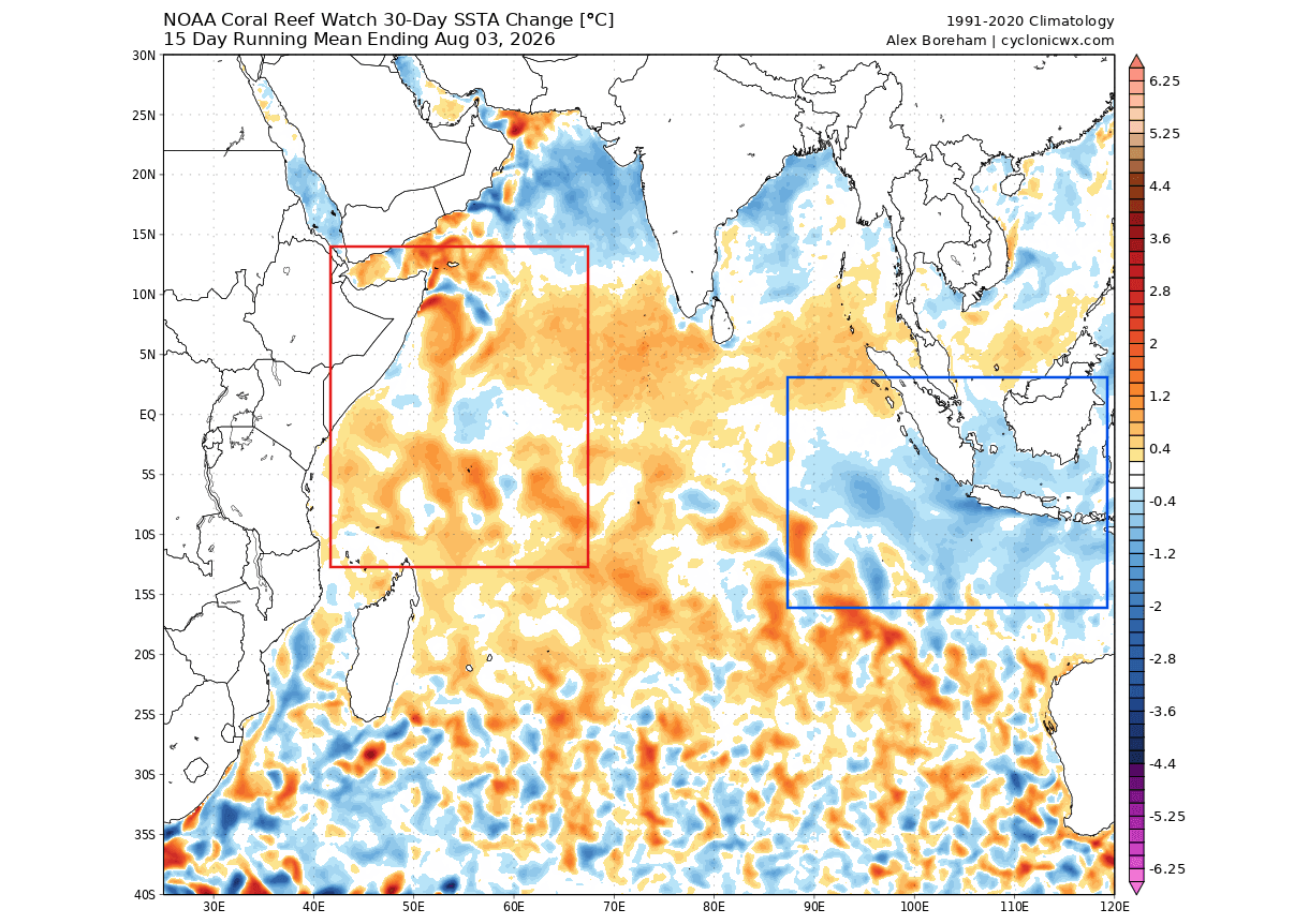
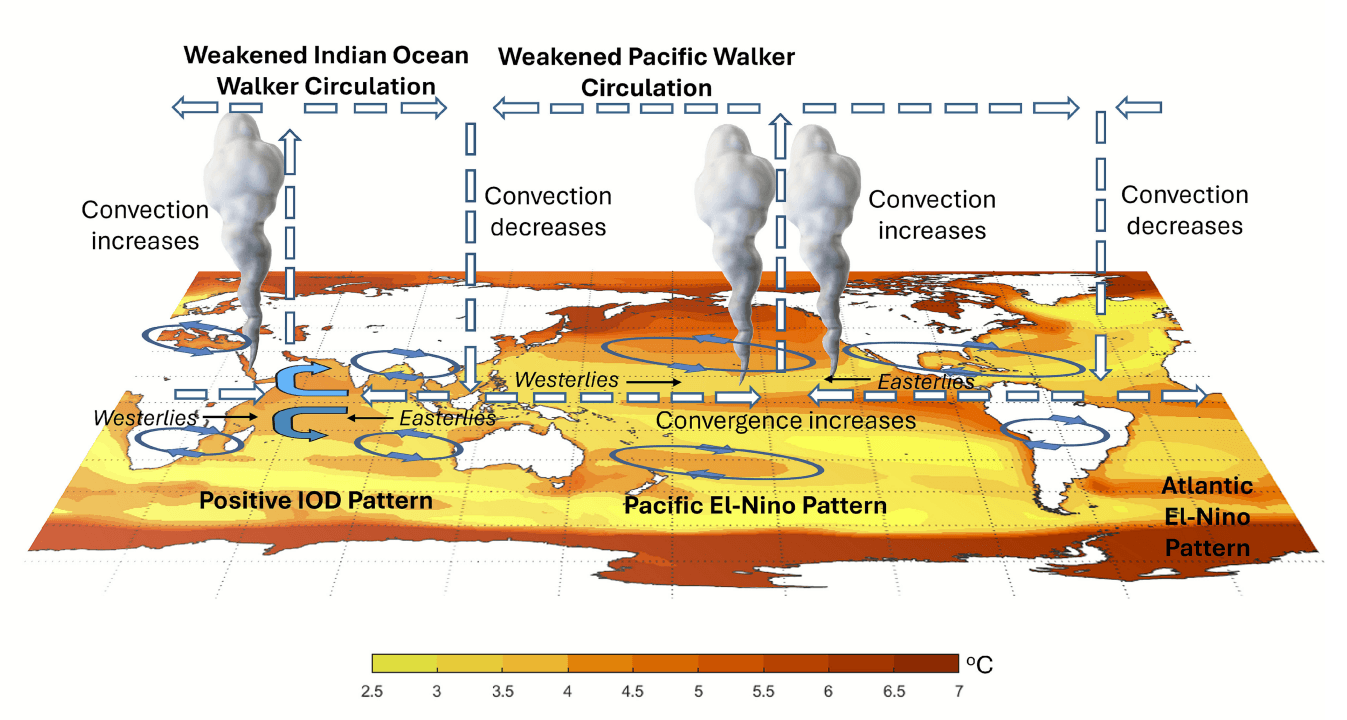
The core of this meteorological shift lies in the interaction between the Pacific and Indian Oceans. While El Niño is a well-known phenomenon characterized by warmer-than-average sea surface temperatures in the central and eastern equatorial Pacific, the Indian Ocean Dipole represents an imbalance in temperatures between the western and eastern Indian Ocean.
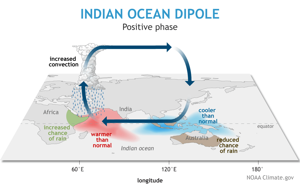
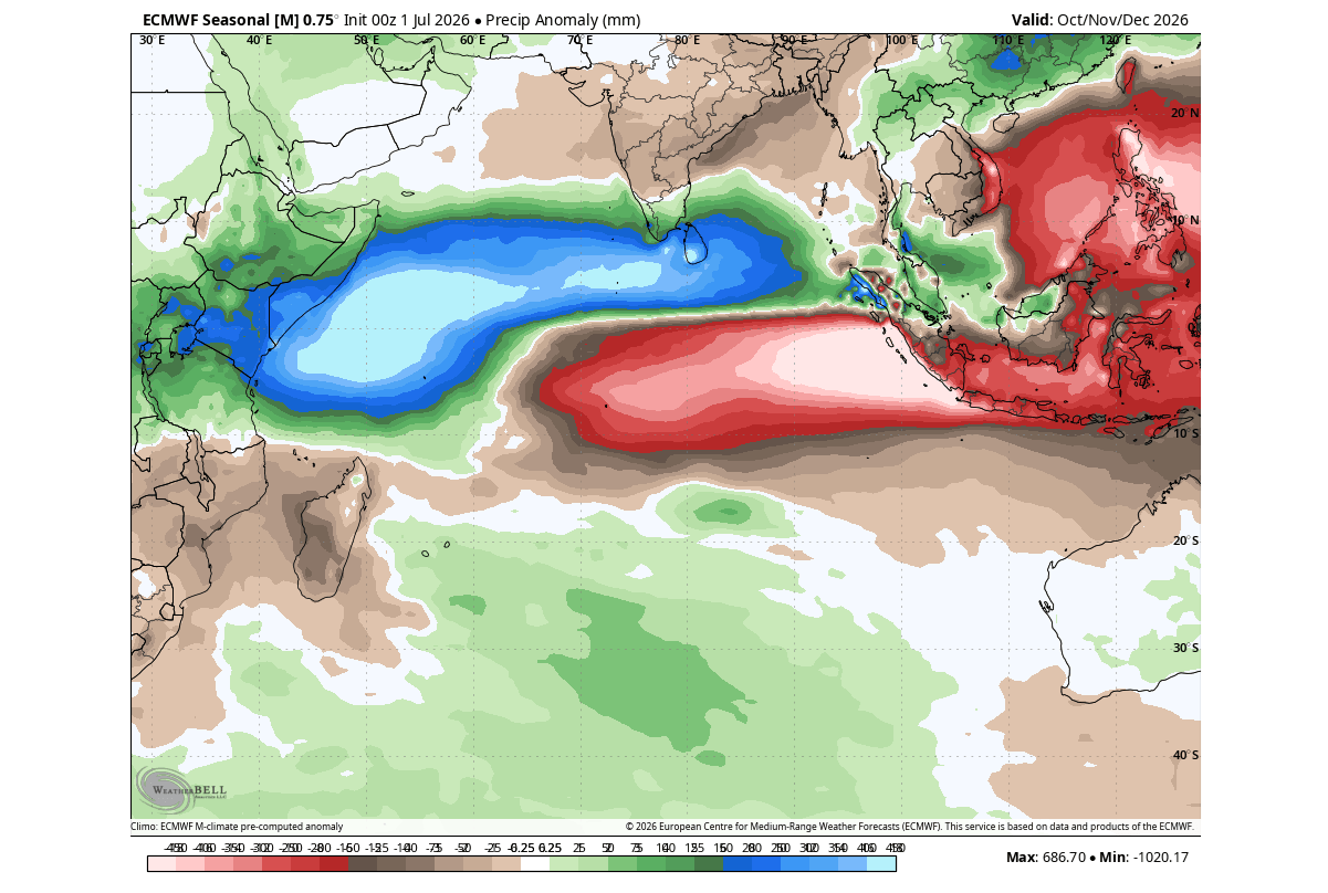
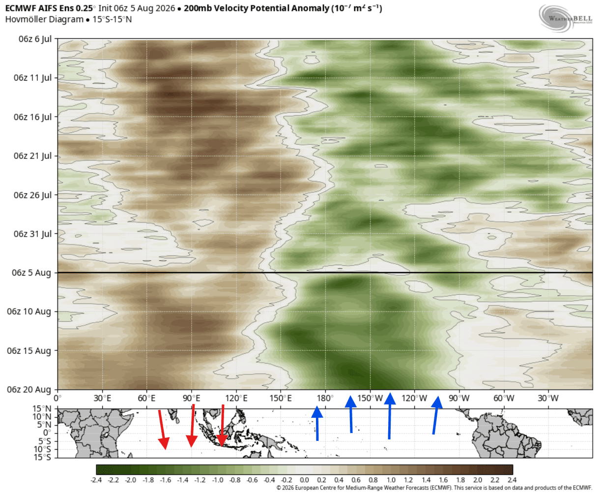
When both systems reach a "positive" phase simultaneously, they create a massive, synchronized tropical forcing mechanism. This "atmospheric bridge" alters the heat and moisture distribution from the tropics to the poles. The rising air over the warmer western Indian Ocean and the central Pacific, coupled with sinking air over Indonesia and the eastern Indian Ocean, creates a persistent, large-scale atmospheric cell. This setup acts as a primary "winter driver," effectively steering the Pacific jet stream and influencing storm tracks far beyond the tropics.
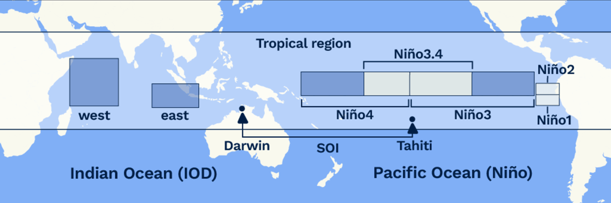
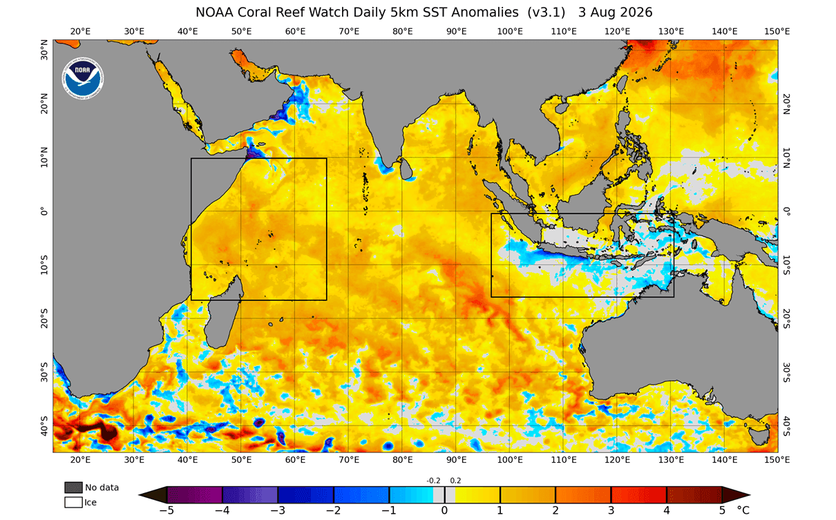
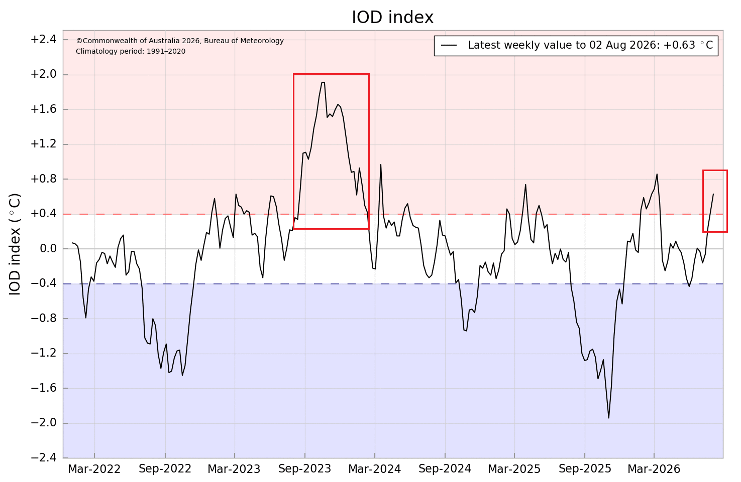
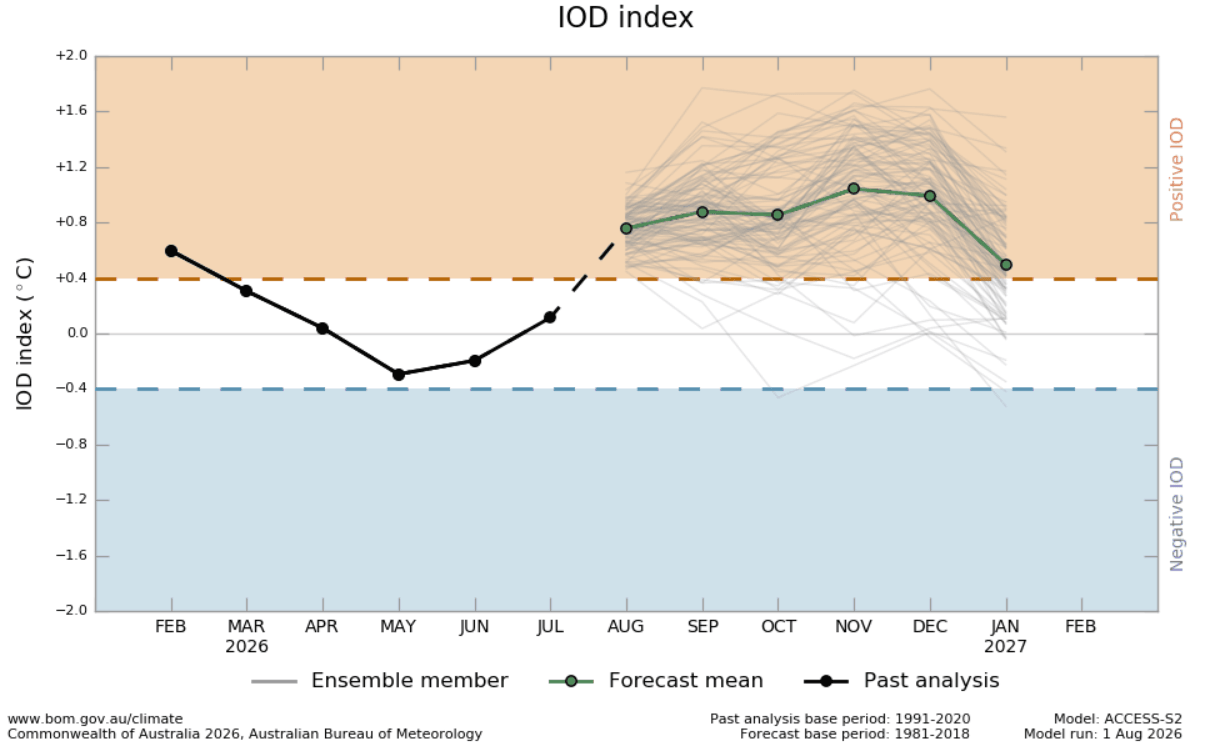
Seasonal forecasts from the European Centre for Medium-Range Weather Forecasts (ECMWF) and other leading climate modeling agencies indicate that this positive IOD phase is expected to persist through the autumn and into the early winter months of 2026. This prolonged alignment ensures that the atmospheric ripple effects will not be a transient event, but a dominant influence on the winter climate of North America and Europe.
Chronology: From Subsurface Anomalies to Global Impact
The development of this event has been tracked with precision throughout the summer of 2026.
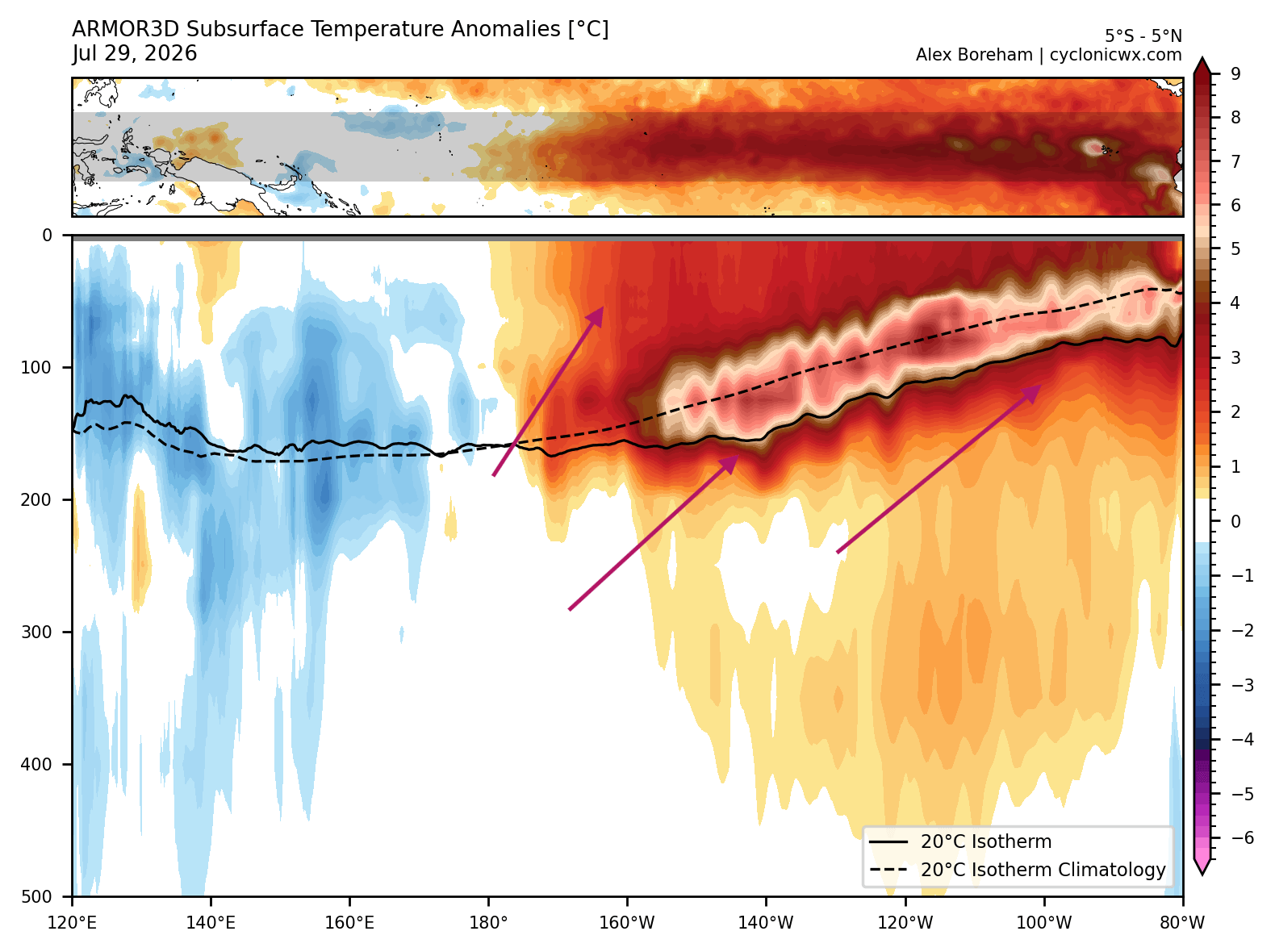
- Early Summer 2026: Oceanographic data revealed the initial formation of a significant Kelvin Wave—a large, warm mass of water beneath the surface of the Pacific. This wave, propelled by shifts in tropical trade winds, moved toward the eastern Pacific, signaling the start of a robust El Niño cycle.
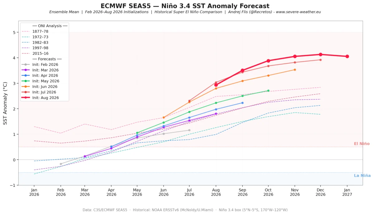
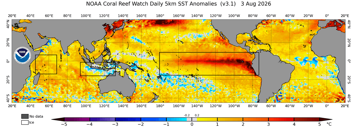
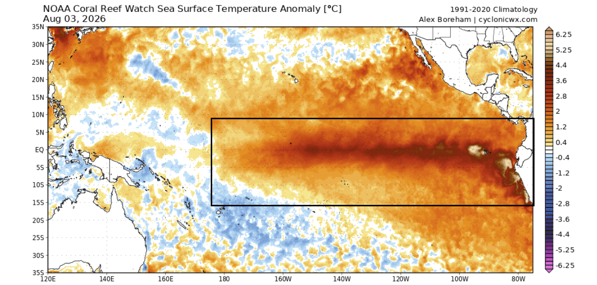
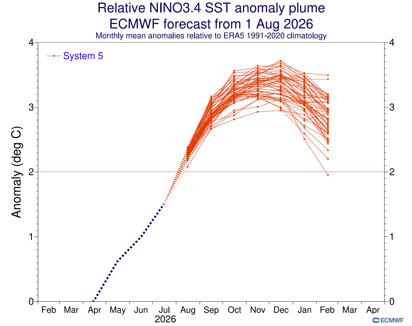
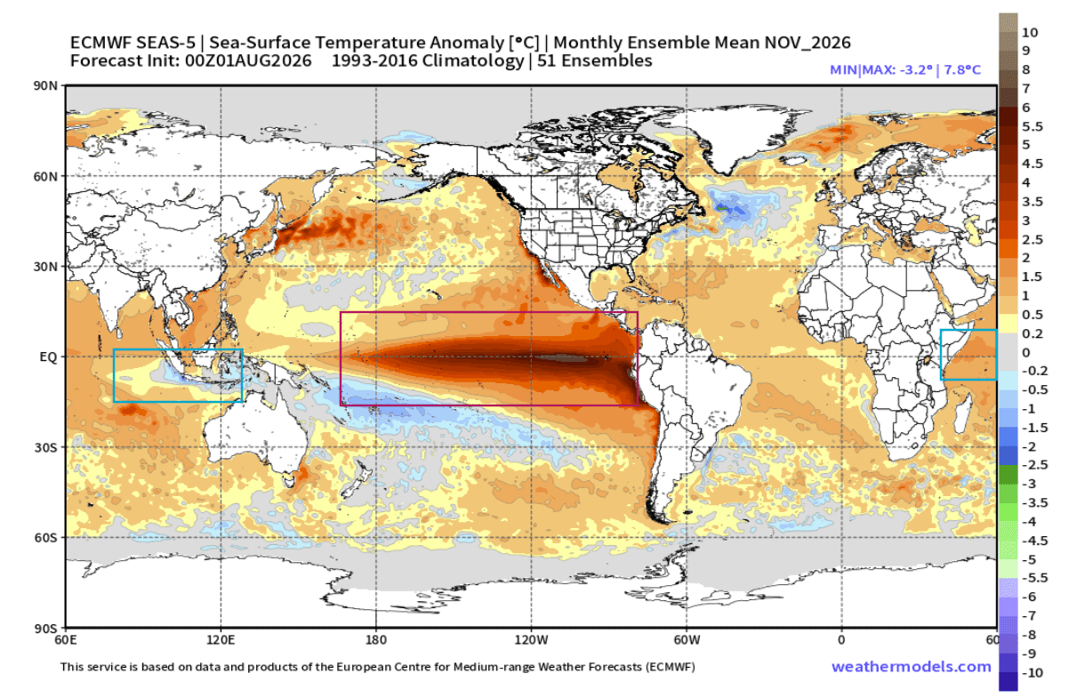
- August 2026: The Super El Niño reached a critical inflection point, with surface anomalies in the eastern ENSO regions surging past the +4°C mark. Concurrently, the Indian Ocean began showing the classic "dipole" signature: cooling in the east and warming in the west.
- Autumn 2026: The coupling of these two systems is projected to fully mature. As the tropical forcing becomes more pronounced, the "atmospheric standing wave"—a persistent pattern of high and low pressure—will lock into place, setting the stage for the winter jet stream configuration.
- Winter 2026/2027: The final phase of the development involves the manifestation of these tropical drivers as a "split-flow" pattern across North America and an amplified westerly flow over Europe.
Supporting Data: Decoding the Atmospheric Engine
The strength of this event is best understood through the lens of subsurface temperature anomalies. The "heart" of the 2026 Super El Niño lies in the top 500 meters of the Pacific, where warm anomalies have exceeded 8°C above normal. This deep core is the engine room of the current climate anomaly.
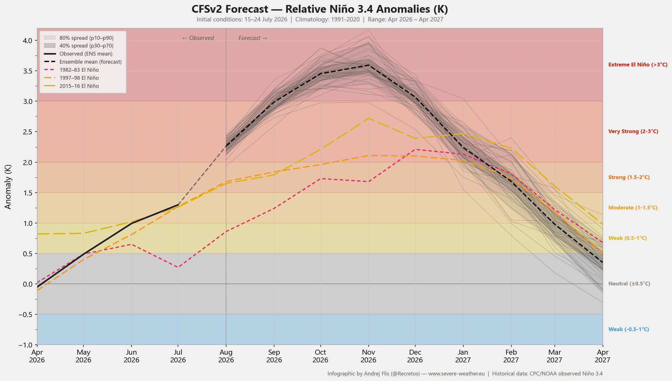
Computer models, including the NCEP CFSv2 and ECMWF ensembles, have been remarkably consistent in their projections. They suggest the El Niño event will reach and likely exceed the +3°C threshold, placing it in the category of one of the strongest events in recorded history.
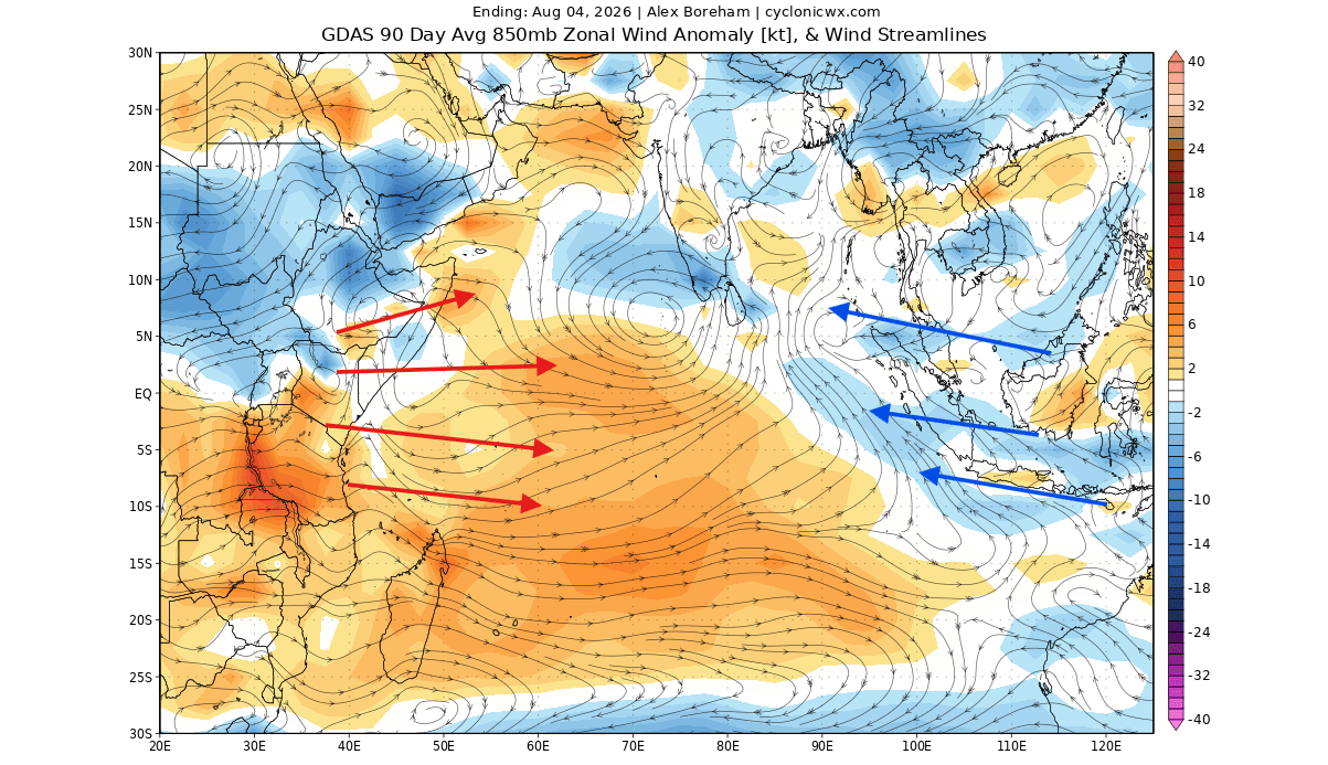
Atmospheric motion analysis confirms this, showing a massive, persistent zone of rising air over the central Pacific and sinking air over the Indian Ocean. This "velocity potential" anomaly is the signature of a fully engaged atmospheric engine. When this "tropical domino effect" reaches the mid-latitudes, it forces a planetary wave train that dictates where high-pressure ridges and low-pressure troughs will reside throughout the winter.
Implications for North America: A Tale of Two Regions
The anticipated atmospheric configuration for Winter 2026/2027 points toward a "split-flow" jet stream. This occurs when the Pacific jet stream is forced into an energetic southern track, while a stubborn high-pressure ridge establishes itself over Canada and the northern United States.
The Southern Storm Track
For the southern and eastern United States, the primary implication is an active, stormy winter. The southern jet stream will act as a conveyor belt, pulling moisture-rich air from the Pacific across the southern tier of the country. When this moisture meets periodic cold-air outbreaks originating from the north, the potential for significant winter storms, ice events, and heavy precipitation increases dramatically. Regions from the Southern Plains to the Mid-Atlantic and the interior Northeast are likely to see increased snowfall anomalies compared to historical averages.
The Northern Disconnect
Conversely, the northern United States, the Pacific Northwest, and most of Canada are projected to experience a milder, drier winter. The dominant high-pressure ridge will likely act as a "boulder in a stream," diverting polar air away from the border and keeping temperatures above average. Snowfall in these regions may be significantly below historical norms, as the primary storm corridor shifts south.
Implications for Europe: Westerly Dominance
Europe’s winter outlook is governed by the downstream effects of this planetary wave train. The research indicates that the synchronized tropical forcing will likely amplify a low-pressure pattern over the North Atlantic and northwestern Europe.
This creates a significant north-to-south pressure gradient, which acts as a "turbocharger" for the westerly winds flowing from the Atlantic into the European continent. The result is a generally milder winter for much of Western and Central Europe, characterized by frequent, wet, and windy conditions rather than long-lasting cold snaps. While some northerly flows may periodically affect the UK, Ireland, and Scandinavia, the overarching trend is one of above-average temperatures and increased precipitation. Snowfall will likely be limited to the higher elevations of the Alps and the extreme northeastern reaches of the continent.
Official Perspectives and Scientific Consensus
Climate scientists emphasize that while these models provide a high level of confidence, the unpredictability of short-term weather variability remains a factor. The "dual-ocean" setup is a statistical driver, not a guarantee of specific daily weather outcomes. However, the alignment of a Super El Niño with a positive IOD provides a clear signal that the atmosphere is primed for a more aggressive, high-amplitude winter.
Research into these dual-forcing events suggests that the "atmospheric domino effect" is more pronounced when these two anomalies work in concert. The resulting wave train creates a chain of high and low-pressure systems that effectively lock the hemispheric weather patterns into place by early December.
Preparing for the Season Ahead
As we look toward the winter months, the data suggests that residents in the Southern and Eastern United States should prepare for an active, potentially volatile winter season. For those in Europe, the outlook leans toward a milder, wetter, and stormier winter.
The meteorological community continues to monitor the "Kelvin Wave" development and the evolution of the IOD index. These systems are not merely distant ocean currents; they are the primary architects of our global climate. As the 2026/2027 winter approaches, the synchronization of these two massive oceanic drivers will remain the most critical factor in predicting the temperature and snowfall trends that will define the coming months.
Stakeholders, from agricultural planners to local municipal emergency services, are advised to monitor the latest updates from the ECMWF and national meteorological agencies as the season progresses, as the precise positioning of the atmospheric wave train can shift, bringing localized impacts that deviate from broader seasonal trends.