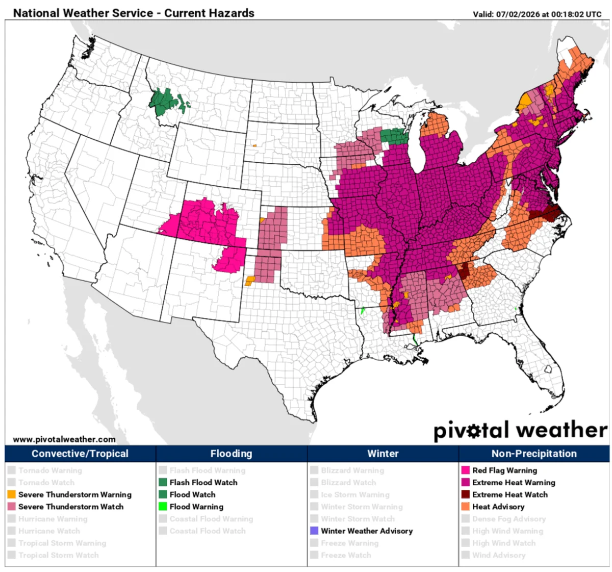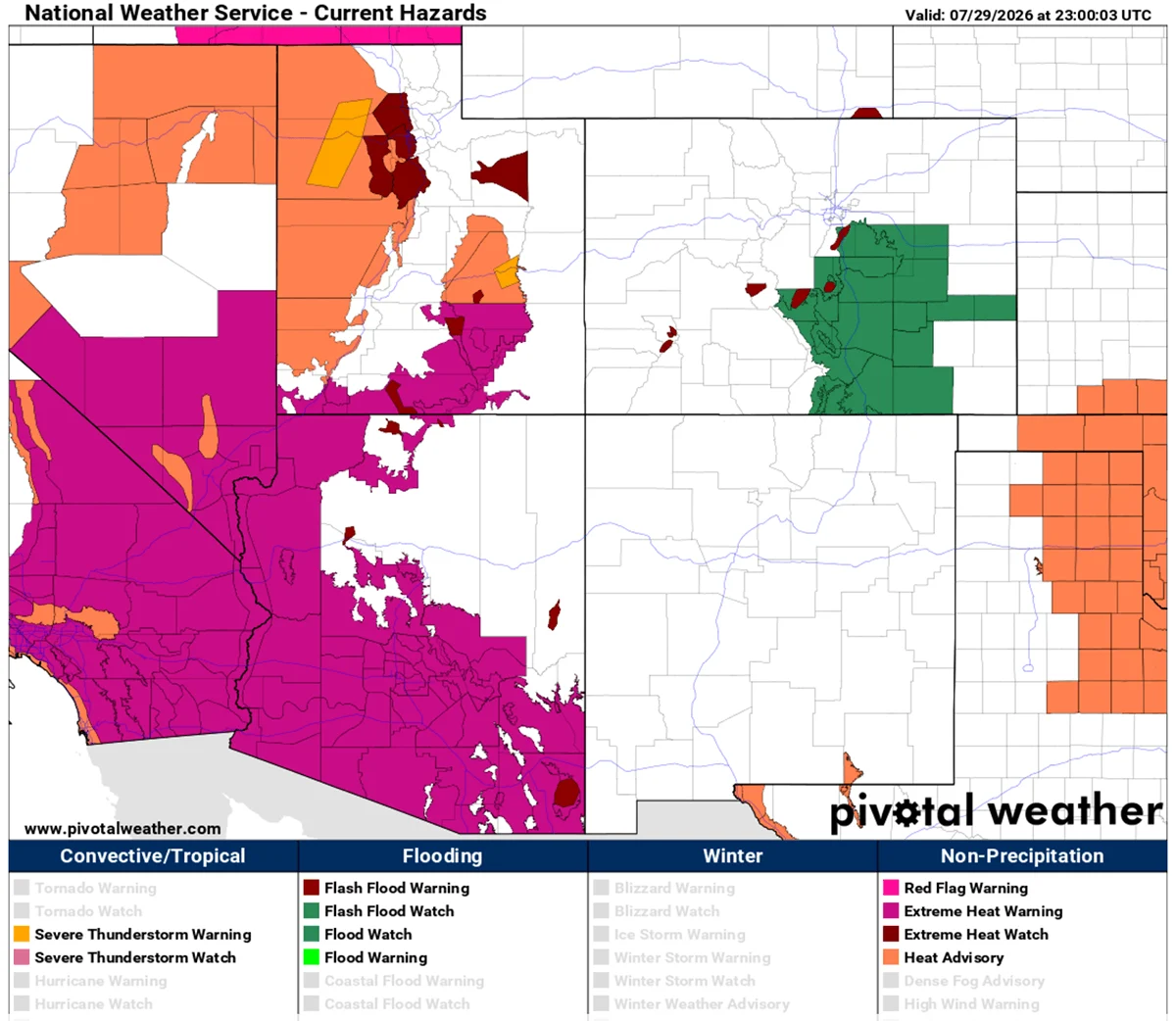
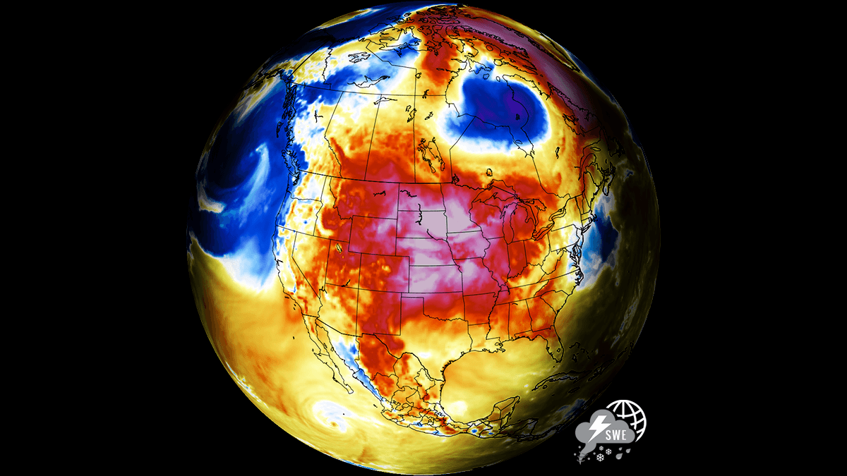
As August dawns, a massive and relentless "Heat Dome"—a high-amplitude, upper-level atmospheric ridge—has locked the United States in a grip of record-shattering temperatures. From the sun-scorched basins of the desert Southwest to the agricultural heartlands of the Great Plains and the humid expanses of the Mississippi Valley, millions of Americans are facing a prolonged period of dangerous, potentially life-threatening heat.
With peak temperatures consistently soaring between 105°F and 110°F, and desert regions bracing for apocalyptic highs of up to 120°F, this meteorological event is not merely a summer inconvenience; it is a significant public health crisis and a massive test for the nation’s power grid.
Main Facts: The Anatomy of a Heat Dome
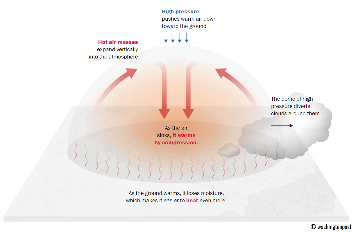
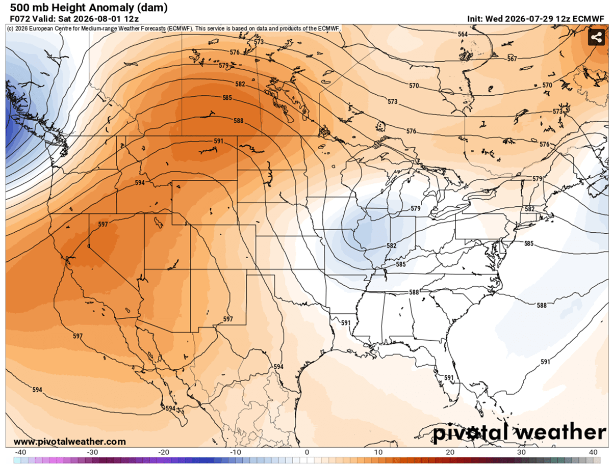
At its core, a heat dome is an atmospheric phenomenon where a broad area of high pressure parks itself over a region, acting much like a lid on a boiling pot. This "blocking high" forces warm air downward, where it is compressed and trapped. As the air sinks, it warms significantly through adiabatic compression, creating a cycle of stagnant, sweltering conditions that can persist for weeks.
In this specific instance, upper-air thermal anomalies are reaching the 99th percentile of historical records. The persistent ridge is preventing the natural circulation of the atmosphere, effectively sealing the heat in place. Unlike standard summer weather, which often allows for some nocturnal cooling, this dome is keeping overnight temperatures trapped between 75°F and 80°F in major urban corridors. This "lack of nocturnal recovery" is perhaps the most dangerous aspect of the current event, as it denies the human body, infrastructure, and the environment the chance to "reset" after the sun goes down.
Chronology: A Multi-Week Thermal Spike
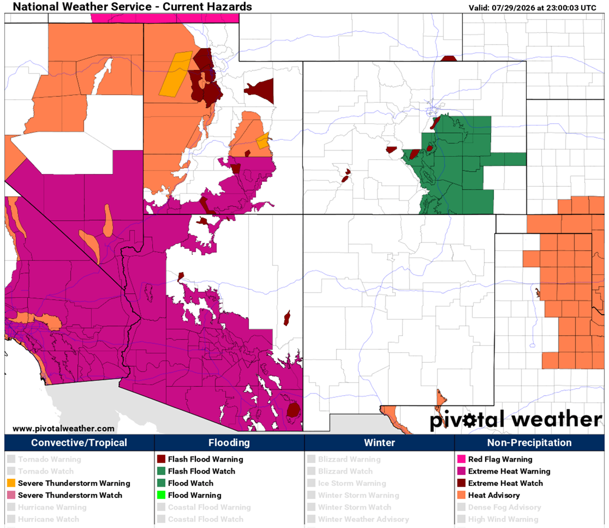
The trajectory of this heatwave began with the steady expansion of an upper-level ridge across the Western U.S. and the Northern Rockies. By late July, the dome had solidified, casting a shadow of excessive heat that stretched from the California coastline through the Great Basin and into the northern plains of Canada.
- Thursday through Saturday: The dome’s core intensity focused on the Central Plains. Texas, Oklahoma, and Kansas saw temperatures climb into the low 100s. Simultaneously, Montana, Wyoming, and the western Dakotas experienced a surge as the dome peaked in strength, pushing surface readings toward the 110°F mark.
- Sunday and Monday: The extreme heat maintained its momentum, with the most severe conditions shifting slightly. While the desert Southwest continued to endure highs of 115°F to 120°F, the central and southern Plains—including New Mexico and the Colorado High Plains—faced sustained peaks of 100°F to 105°F.
- Early August Outlook: While some relief is projected for the northern High Plains by mid-week as a frontal system pushes eastward from Canada, the sheer inertia of this system suggests that the heat will remain a dominant feature for much of the central United States well into the first week of August.
Supporting Data: Atmospheric Dynamics and Thermal Anomalies
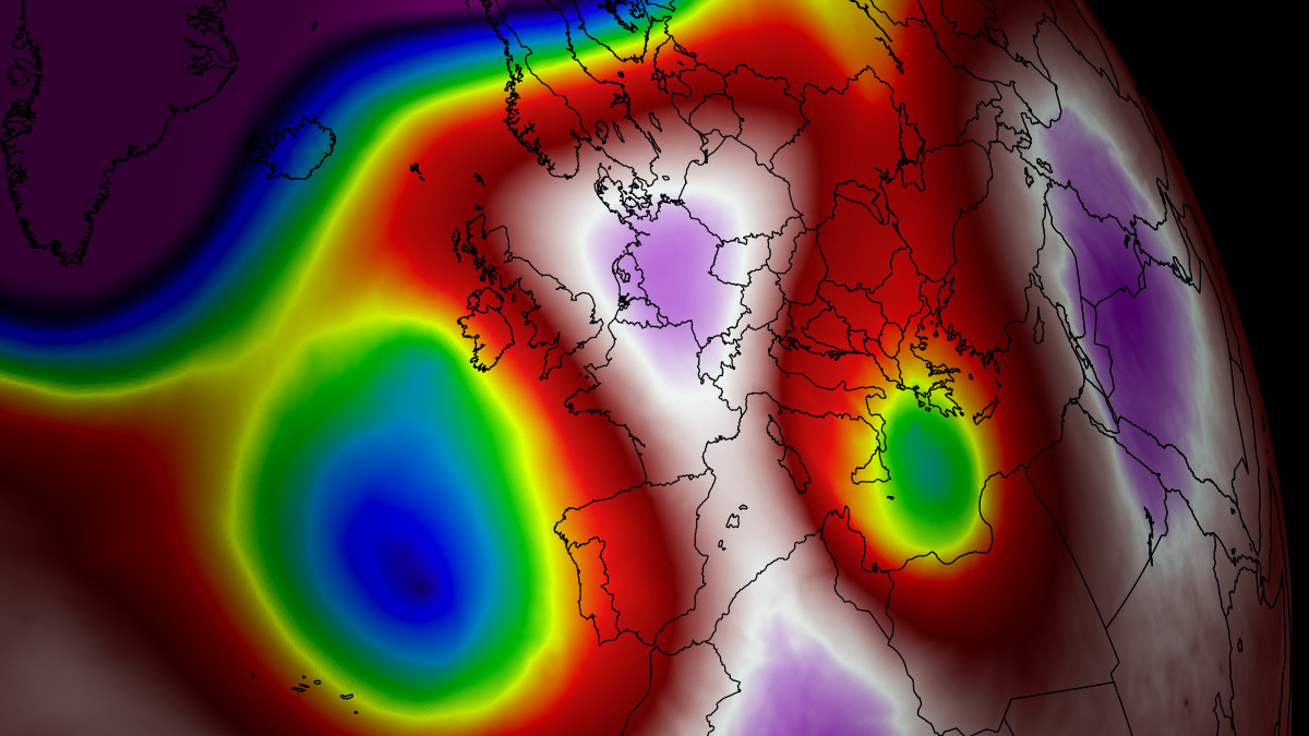
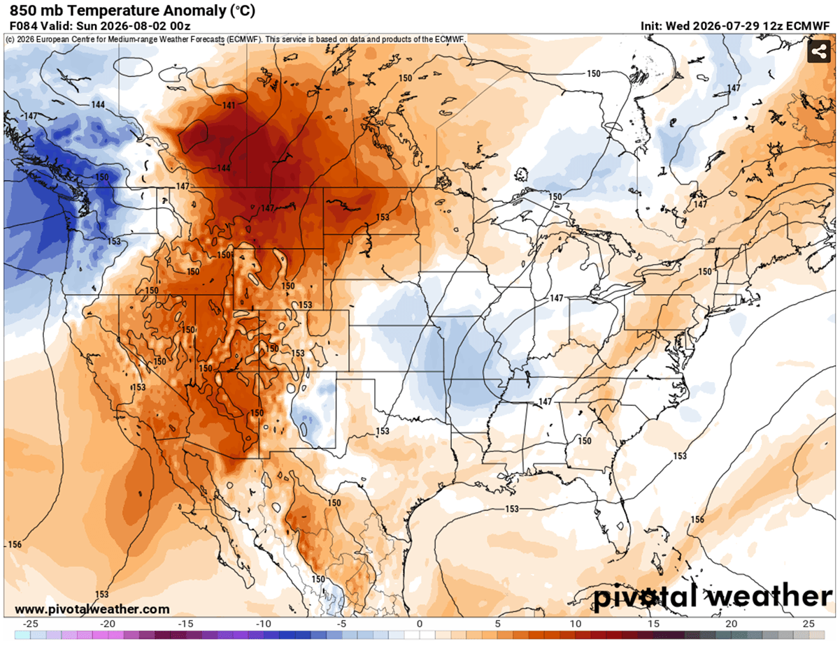
Meteorological models provided by platforms such as PivotalWeather and WXcharts illustrate the severity of the 850 hPa temperature anomalies currently observed. The 850 hPa level (roughly 5,000 feet above sea level) is a critical metric for meteorologists because it avoids surface-level turbulence and provides a clearer picture of the actual air mass temperature.
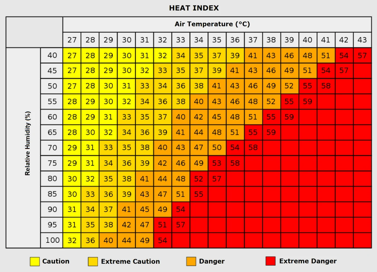
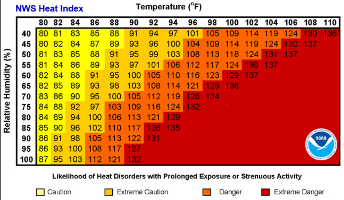
The data confirms that this is not a localized event. The "omega block" pattern—a specific atmospheric configuration that causes weather systems to stall—has anchored the heat across the continent. When humidity is factored in, the "Heat Index" creates an even more alarming picture. For example, an air mass at 90°F with 80% humidity can result in a "feel" temperature exceeding 113°F. This creates a physiological barrier where human sweat cannot evaporate, rendering the body’s natural cooling mechanism ineffective.
Implications: Health Risks and Grid Vulnerability
The societal cost of such a prolonged heatwave is multifaceted, impacting everything from individual biological health to national economic stability.
The Human Toll
Prolonged exposure to extreme heat, particularly without nocturnal cooling, significantly increases the risk of heat exhaustion and heat stroke. Vulnerable populations—the elderly, young children, and those with pre-existing cardiovascular or respiratory conditions—are at the highest risk. Furthermore, those living in urban "heat islands," where concrete and asphalt absorb and re-radiate solar energy, suffer disproportionately.
Occupational hazards are also at an all-time high. Agricultural workers, construction crews, and those in the logistics sector are being pushed to their physical limits. The medical community warns that heatwaves are not just about heat-related illness; they correlate with spikes in heart attacks, strokes, and chronic respiratory failure as the body struggles to maintain homeostasis under extreme thermal stress.
Infrastructure and Energy Grid Strain
The "lid on the pot" effect creates a feedback loop for power grids. As temperatures climb, the demand for air conditioning skyrockets, placing immense strain on regional energy providers. When the grid is forced to operate at maximum capacity during a heatwave, the risk of localized brownouts or broader failures increases, which can be catastrophic for those relying on medical equipment or those without access to cooling centers.
Agricultural and Economic Impact
Beyond the human and energy sectors, the environment is suffering. The persistent heat is causing rapid soil moisture depletion. For the agricultural belts of the Great Plains, this accelerates drought conditions, potentially impacting crop yields for the current season. The economic ripple effects of reduced agricultural output, combined with the high cost of cooling, present a significant hurdle for regional economies.
Official Responses and Safety Recommendations
As the heat dome continues to affect such a large swath of the country, regional authorities and national meteorological services have issued a cascade of Excessive Heat Warnings. Official guidance consistently emphasizes the "three pillars" of heat safety:
- Hydration: Do not wait until you are thirsty to drink water. Electrolyte replacement is critical, especially for those working outdoors.
- Environment: Seek air-conditioned environments during the peak hours of 12:00 PM to 6:00 PM. If home cooling is unavailable, utilize designated community cooling centers.
- Monitoring: Check on neighbors, particularly the elderly, and be aware of the signs of heat-related illness, which include dizziness, rapid pulse, nausea, and confusion.
Conclusion: Looking Ahead
The current atmospheric configuration serves as a sobering reminder of the power of high-pressure systems to dictate the quality of life across the continent. While the models suggest that a frontal system will eventually provide a reprieve for the northern plains, the persistent nature of this dome highlights the importance of long-term climate preparedness.
As we move deeper into August, meteorologists remain vigilant. The transition from this stagnant, record-breaking heat to a more seasonal pattern will depend on the movement of the upper-level flow. Until that shift occurs, the message remains clear: the heat is not merely a background weather condition—it is an active, evolving threat that requires sustained caution and collective effort to mitigate.
For real-time updates and localized emergency information, residents are encouraged to monitor their local National Weather Service offices and local government alerts. The situation remains fluid, and as the atmosphere continues to cycle, further adjustments to regional forecasts are expected in the coming days. Stay informed, stay hydrated, and remain cognizant of the limitations of both the body and the grid during this extreme weather event.