Executive Summary: A Significant Meteorological Event
A potent and highly dangerous weather system is set to sweep across Europe from Thursday, August 27, through Friday, August 29, 2026. Forecasters at Severe Weather Europe, led by meteorologist Marko Korosec, have issued urgent warnings regarding a two-day severe weather outbreak that threatens to bring catastrophic conditions to parts of Western and Central Europe.
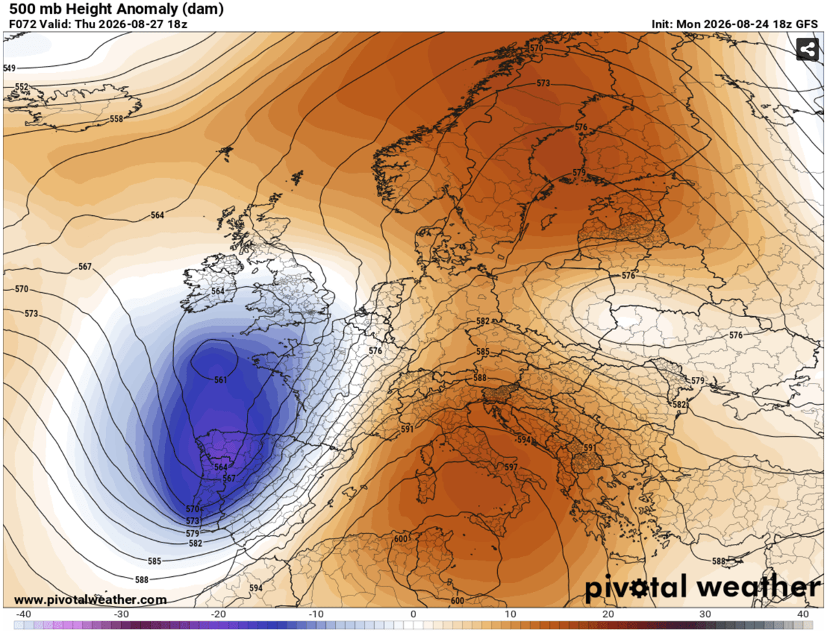
The atmospheric setup is characterized by a collision of extremes: a deep, unstable upper-level trough pushing eastward from the Atlantic and a persistent, high-pressure "blocking" ridge anchored over the Mediterranean. This configuration has created a textbook environment for explosive convective development. Residents across Eastern France, Switzerland, Germany, Austria, the Czech Republic, and Poland are urged to monitor local forecasts closely as the risk profile includes giant hail, hurricane-force wind gusts, flash flooding, and potential tornadic activity.
Chronology: The Evolution of the Storm System
Thursday, August 27: The Initial Strike
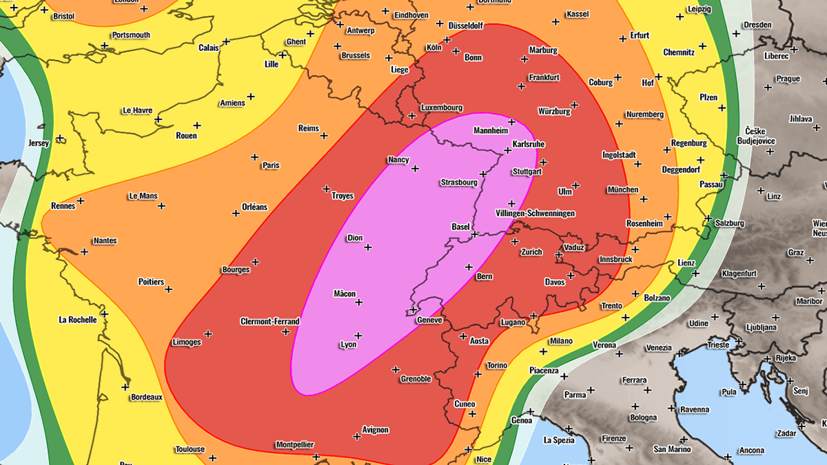
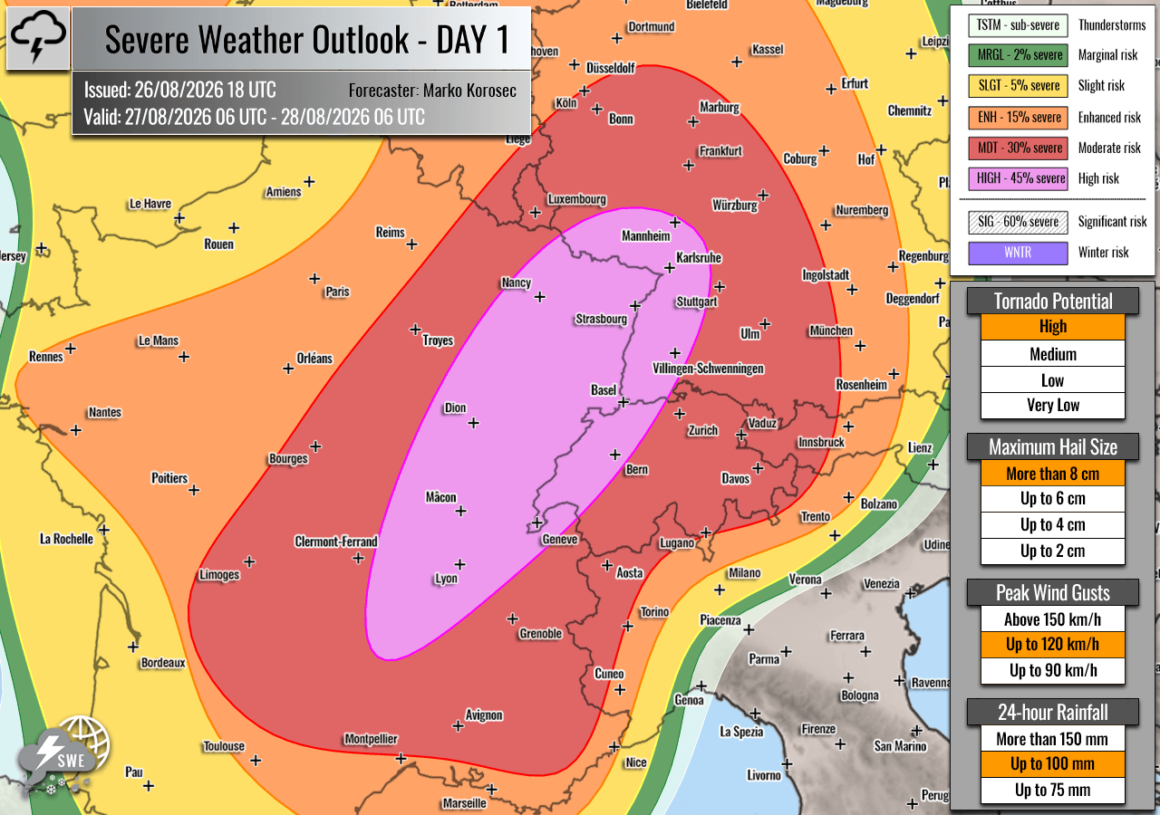
The severe weather event is expected to initiate on Thursday afternoon, primarily targeting Eastern France, Western Switzerland, and Southwestern Germany. The synoptic environment here is primed for violence.
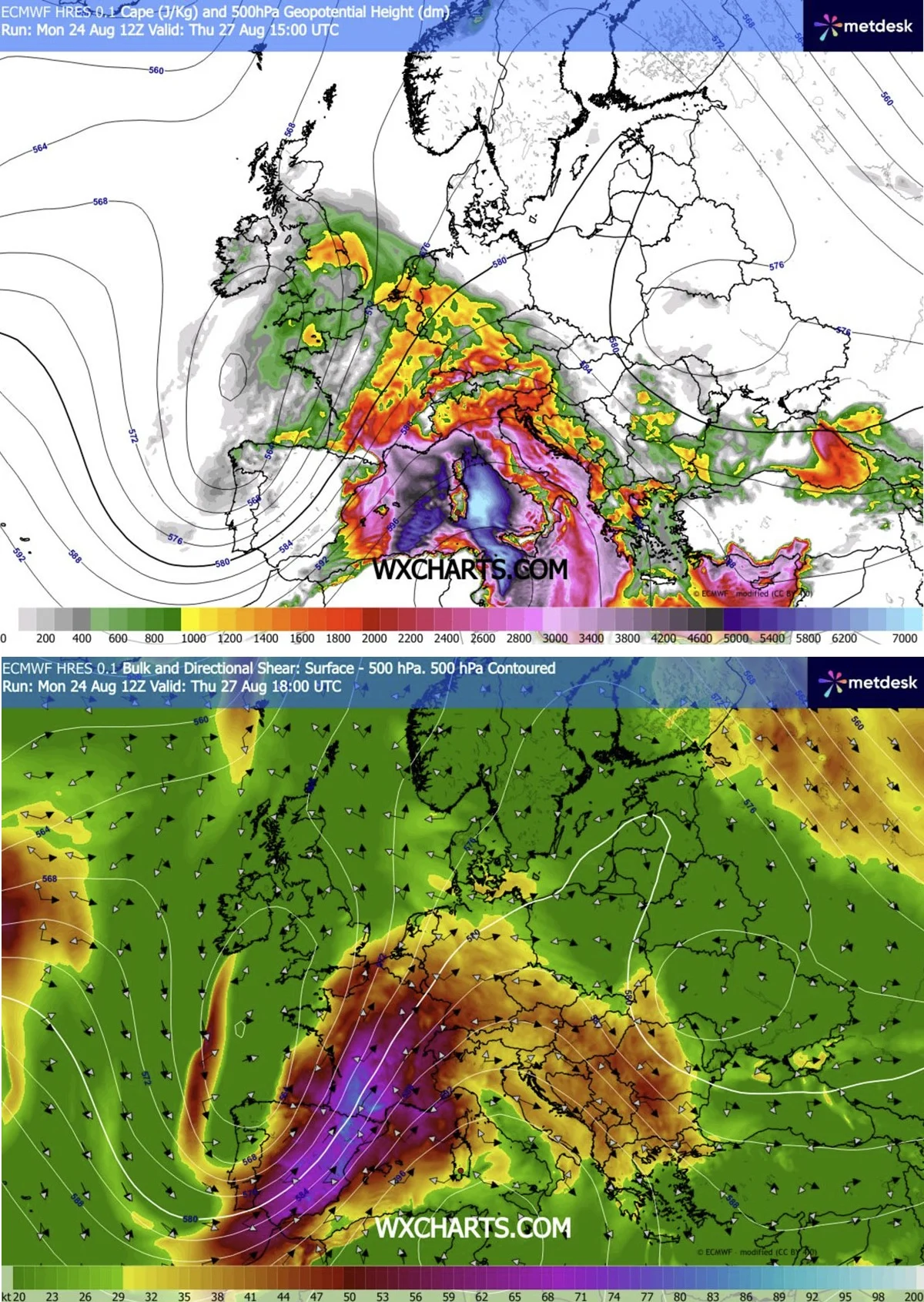
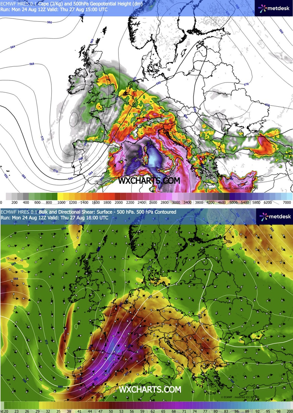
As the cold front pushes from the west, it will encounter a pocket of air characterized by extreme moisture and instability, with MLCAPE (Convective Available Potential Energy) values forecasted to reach between 2,000 and 4,000 J/kg over southeastern France. These energy levels, combined with significant wind shear provided by a powerful southwesterly jet stream, create the perfect "engine" for supercell development.
Meteorologists anticipate that storms will erupt near the Massif Central by midday, rapidly intensifying as they track into the Rhone Valley. Here, the combination of high dewpoints and localized low-level wind shear increases the probability of tornadic supercells. By evening, these storms are expected to consolidate into massive convective clusters, moving northeastward into Germany. The Benelux region and Southern England may also experience isolated, yet intense, storm activity as the wave axis crosses.
Friday, August 28: The Alpine and Central European Surge
The second phase of this event shifts the focus toward the Alps, Southern Germany, the Czech Republic, and Southwestern Poland. As the convective systems move out of the mountains, they will likely coalesce into a large-scale Mesoscale Convective System (MCS).
The transition from Thursday to Friday will see the storm mode evolve from individual supercells into a potentially destructive line of storms. Forecasters are particularly concerned about the "bowing segments" of these storms—a structural characteristic often associated with long-lived, high-velocity wind events. If these systems organize as expected, destructive wind gusts exceeding 120 km/h could rake across the landscape, causing widespread structural damage and power outages.
Supporting Data and Meteorological Mechanics
The Synoptic "Pressure Cooker"
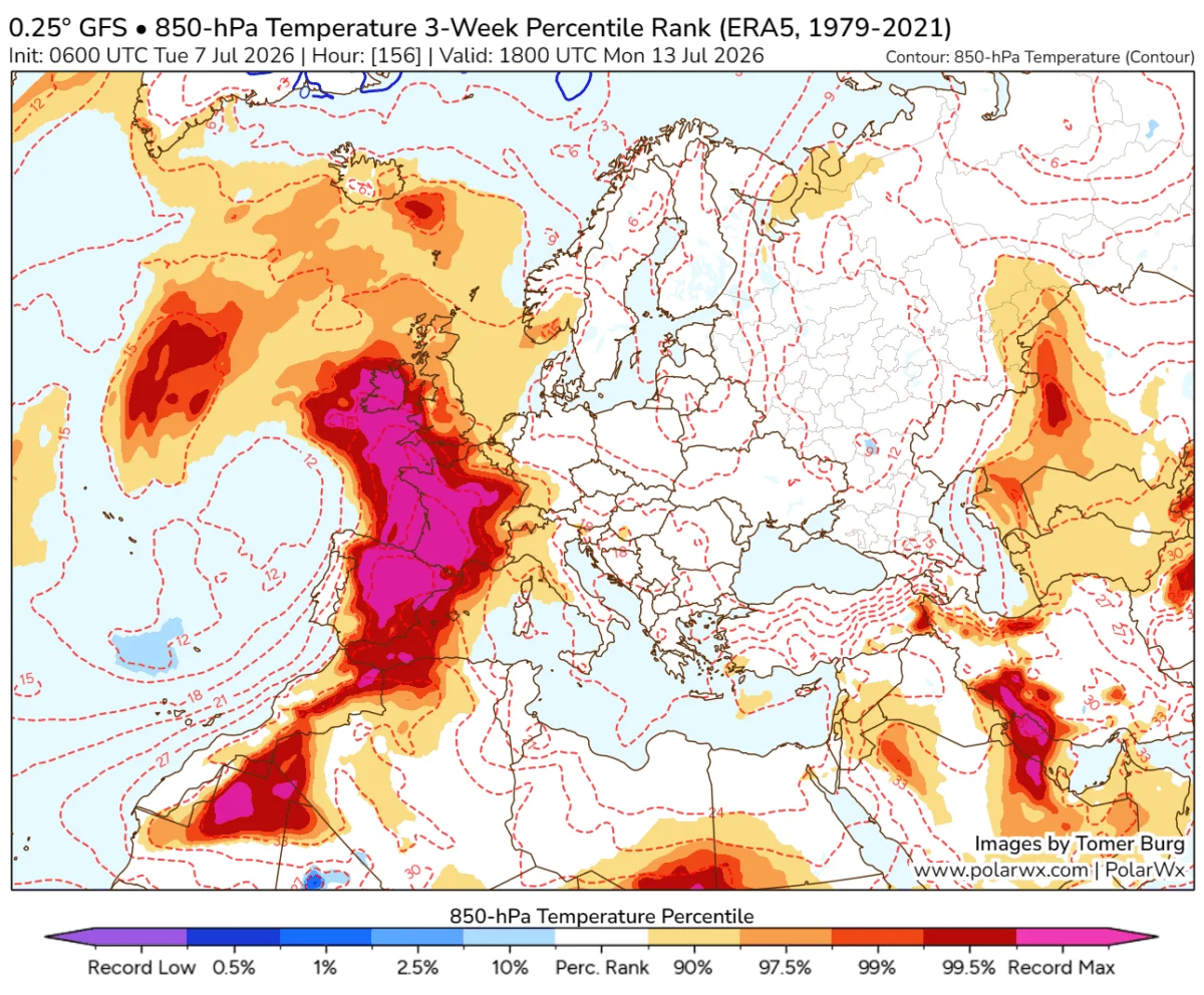
The core of this event lies in the extreme temperature and pressure gradients generated between the Mediterranean heatwave and the incoming Atlantic trough. The Mediterranean region has been suffering under prolonged heat, which has acted as a thermal reservoir. When the cool, dense air of the Atlantic trough moves in, the resulting density differential acts as a massive propellant for the air mass.
Wind Shear and Helicity
The jet stream, flowing from Spain toward the Alps, is providing the essential "ventilation" for these storms. By tilting the updrafts of the developing thunderstorms, the vertical wind shear prevents the storms from "choking" on their own rain-cooled air, allowing them to sustain intensity for hours. In the Rhone Valley, the specific interaction of the low-level jet and the local topography is expected to maximize storm-relative helicity, a primary metric for identifying the potential for rotating updrafts—the precursor to tornadoes.
Flash Flood Potential
Because the atmosphere is saturated with moisture, the precipitation efficiency of these storms will be exceptionally high. Even in regions where the storm duration is short, the intensity of the rainfall—often described as "torrential"—poses a severe threat of flash flooding. Urban areas with limited drainage and mountainous regions prone to landslides must be on high alert.
Implications for Public Safety and Infrastructure
The "HIGH Risk" Designation
The designation of "HIGH risk" in meteorology is rarely used and signifies that severe weather is not just possible, but expected to be widespread and intense. For the zones highlighted in purple across Eastern France and Western Switzerland, this indicates that the atmospheric conditions are reaching their theoretical maximum for the season.
Potential Impacts
- Infrastructure Damage: Winds exceeding 120 km/h are capable of uprooting mature trees, damaging roofs, and destroying power lines. Residents should prepare for prolonged power outages.
- Transportation Disruption: Intense rainfall will likely lead to rapid water accumulation on motorways, leading to hydroplaning risks and localized flooding of low-lying tunnels and underpasses.
- Agricultural Losses: With hail sizes predicted between 6 cm and 10 cm (the size of a tennis ball or larger), agricultural damage in regions like the Czech Republic and Poland could be severe, potentially stripping crops and damaging orchards and greenhouses.
- Public Health: The combination of extreme heat preceding the storms and the subsequent violent weather creates a dual-risk environment. Vulnerable populations should ensure they have access to cooling and, subsequently, a secure shelter.
Official Recommendations and Preparedness
As this weather system approaches, national meteorological services across Europe are coordinating with emergency management agencies. The following steps are recommended for those in the path of the storm:
- Secure Property: Move vehicles into garages or under solid covers to protect against giant hail. Secure loose outdoor furniture, trampolines, and garden equipment that could become projectiles in high winds.
- Monitor Local Updates: Severe Weather Europe and local national agencies will be providing real-time updates. Do not rely on static forecasts; stay tuned to local radio or official weather apps that provide push notifications.
- Identify Shelter: Know the safest room in your home—typically a basement or an interior room on the lowest floor, away from windows. If caught outdoors, seek immediate shelter in a sturdy building. Never attempt to drive through flooded roads.
- The "Turn Around, Don’t Drown" Rule: Most fatalities during flash flood events occur when individuals attempt to drive through flooded roadways. Even a few inches of moving water can sweep a vehicle off the road.
Conclusion: A Critical 48 Hours
The period from August 27 to August 29 represents a high-impact window for Europe. The combination of dynamic forcing, massive moisture availability, and the extreme instability of the atmosphere warrants the highest level of caution. While modern meteorological models have become increasingly adept at predicting the general path of these systems, the specific location of individual supercells remains subject to minute-by-minute atmospheric changes.
The public is urged to treat this forecast with the utmost seriousness. Whether through the direct threat of large hail or the indirect threat of flash flooding, this event has the potential to cause significant societal disruption. Vigilance and preparation remain the best defenses against the volatile power of the European atmosphere.
Data and analysis provided in this report are based on the latest synoptic model outputs from Meteoadriatic, Wxcharts, and PivotalWeather. For continuous updates, please refer to official local weather bureaus in your respective countries.