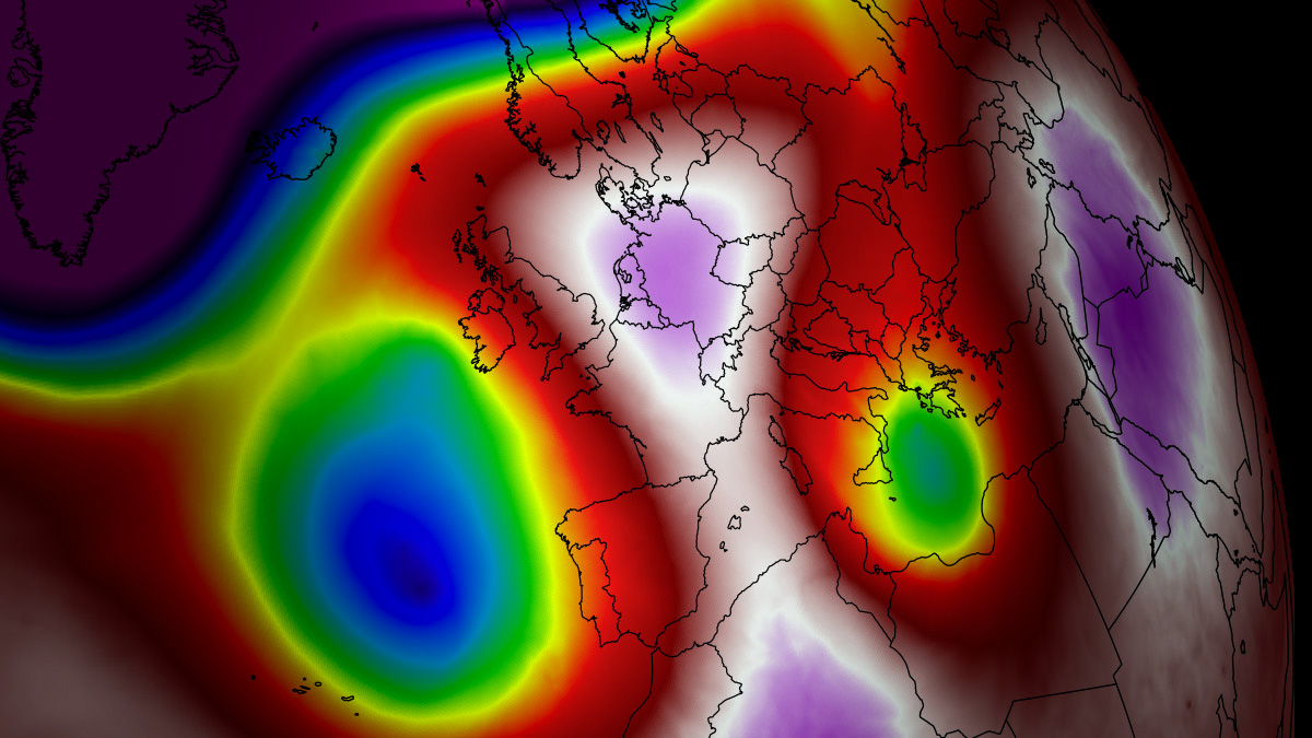
As mid-August 2026 settles over the European continent, a meteorological phenomenon of extraordinary proportions is unfolding. A high-amplitude upper-level ridge has locked a massive "Heat Dome" over Western and Central Europe, marking the fifth—and arguably most severe—thermal event of the current season. With atmospheric thermal anomalies climbing into the 99th percentile, the continent is bracing for a sustained period of extreme, record-challenging temperatures that threaten public health, energy infrastructure, and agricultural stability across a vast swathe of the Northern Hemisphere.
The Atmospheric Engine: Anatomy of a Heat Dome
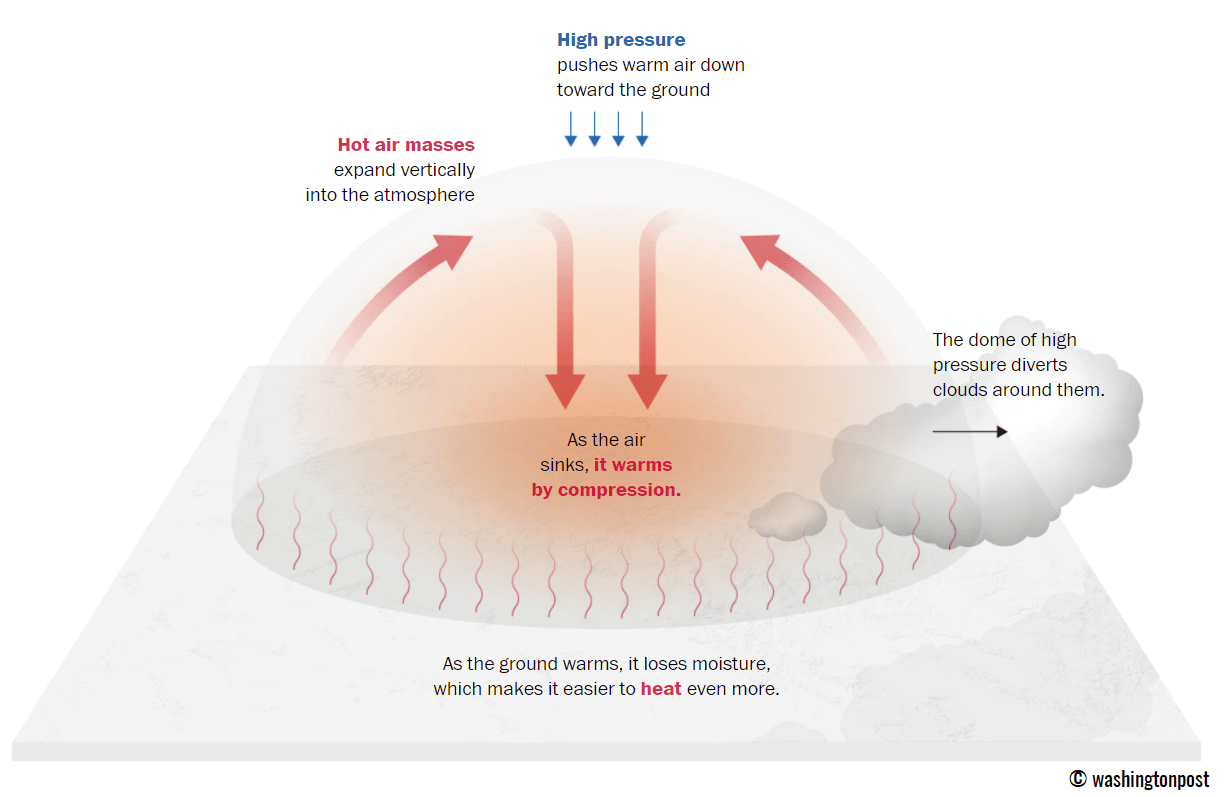
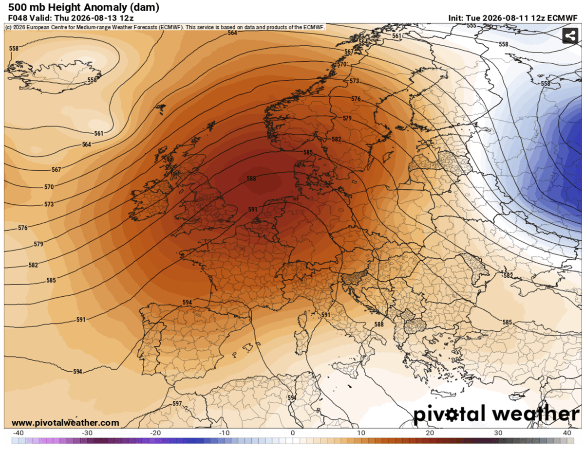
The primary driver of this heatwave is a stubborn, stationary high-pressure ridge parked over the heart of Europe. In meteorological terms, this system acts as a "lid on a pot." As air sinks from the upper troposphere, it undergoes adiabatic compression, significantly warming as it descends toward the surface. Because this high-pressure system is remarkably stable, it traps this sinking, warmed air, preventing the vertical mixing that would typically offer relief.

This process is not merely a seasonal occurrence; it is a manifestation of an intensified atmospheric circulation pattern. By preventing cooler maritime air from penetrating the interior, the heat dome creates a feedback loop. As the soil dries out—already strained by previous heatwaves this year—the sun’s energy is used entirely for sensible heating of the air rather than evaporation, leading to temperatures that consistently exceed 40°C in low-lying basins and plains.
Chronology of the Thermal Surge
The progression of this event is defined by a slow, calculated eastward migration.
Mid-Week: The Western Front
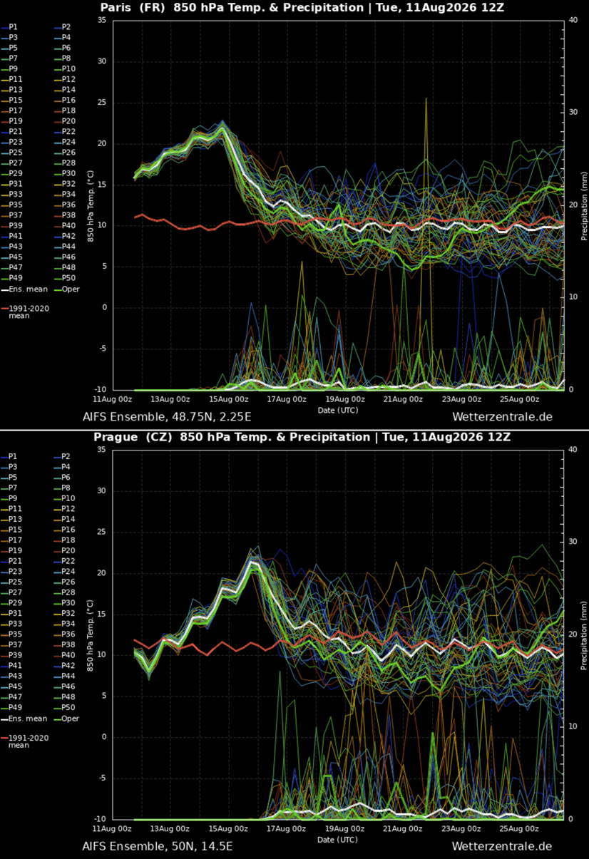
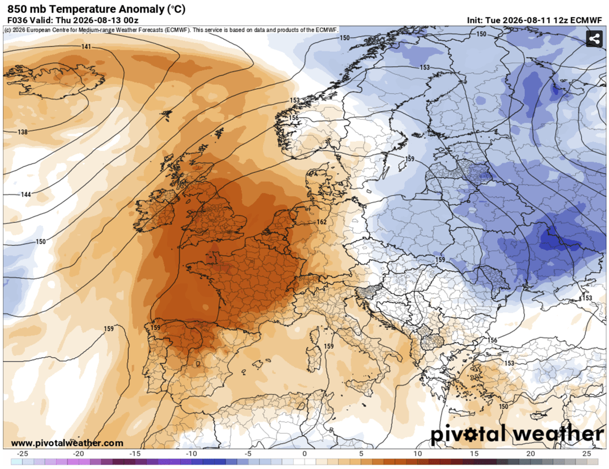
Beginning Wednesday, the heat dome consolidated its strength over the Iberian Peninsula, France, and the United Kingdom. By Thursday, the core of the thermal anomaly reached its peak intensity over northern France and the English Channel. In these regions, temperatures soared into the 40°C to 43°C range. For the United Kingdom, Thursday served as the most critical day, with southern and central England witnessing temperatures climbing to a blistering 38°C–39°C, testing the limits of infrastructure designed for much cooler temperate climates.
Friday: The Peak of the Western Shift
Friday continues the trend of extreme heat, with the Benelux region and Western Germany joining the epicenter. Belgium, Luxembourg, and the southern Netherlands are currently experiencing peak temperatures in the 36°C to 40°C range. The persistence of these temperatures—coupled with a lack of cloud cover—has left these regions under a sustained red-level alert for thermal distress.
The Weekend: Eastward Migration
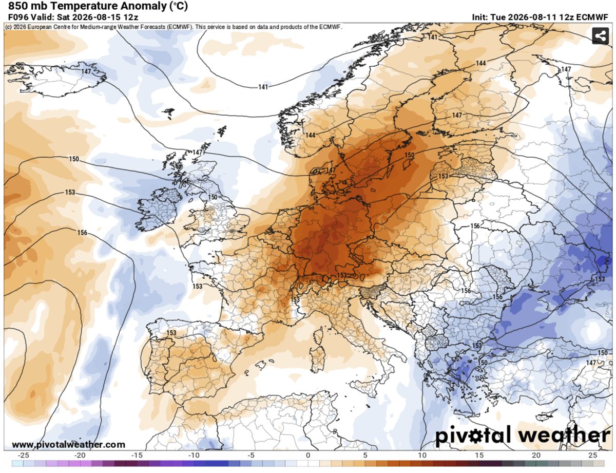
As the weekend approaches, the atmospheric pattern undergoes a subtle shift. The upper-level wave over the Atlantic is expected to weaken, causing the heat dome to elongate and shift eastward. Consequently, the focus of the extreme heat will transition toward Germany, Poland, the Czech Republic, the Alpine region, and the northern Balkans. Residents in these areas should prepare for a sharp climb in temperatures starting Saturday, with the Pannonian plains expected to face some of the highest thermal readings by Sunday.
Regional Breakdown: Where the Heat Bites Hardest
The geographic reach of this fifth heat dome is expansive, with unique impacts for each territory:
- Iberia: Southern Spain and Portugal are enduring the most persistent heat, with forecasts indicating peaks of 42°C to 44°C in the valleys. This heat is particularly dangerous given the region’s susceptibility to rapid, uncontrolled wildfires.
- France: Often the primary focus of these European heat events, France is seeing widespread 40°C+ readings. The lack of relief is the defining feature, as "tropical nights"—where temperatures refuse to drop below 24°C—are becoming the new norm in major urban corridors like Paris and Lyon.
- Central Europe and the Balkans: As the dome drifts east, countries like Hungary, Serbia, and Croatia will experience the full brunt of the system. The heat here is often accompanied by drier conditions, increasing the risk of agricultural drought and further straining water supplies.
- The UK and Ireland: While typically accustomed to milder weather, the UK is currently facing an intensity of heat that is statistically anomalous. The rapid transition from Atlantic-influenced weather to continental heat dome conditions creates significant physiological shock for the population.
The Silent Killer: Nocturnal Heat Stress and Public Health
Beyond the headline-grabbing daytime highs, the most significant danger lies in the lack of nocturnal cooling. In normal conditions, the human body uses the night to shed the thermal load accumulated during the day. However, when overnight lows refuse to dip below 22°C to 26°C, the body remains in a state of constant, high-alert physiological stress.
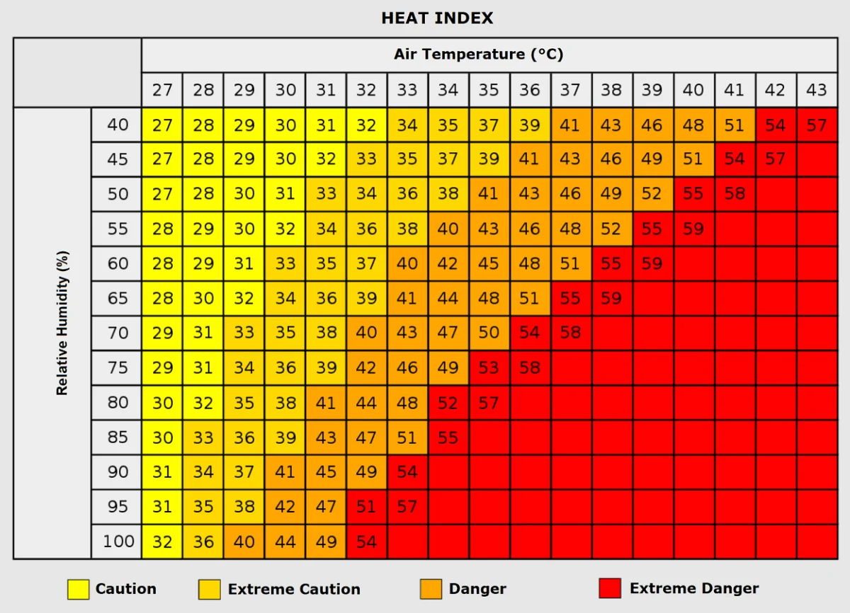
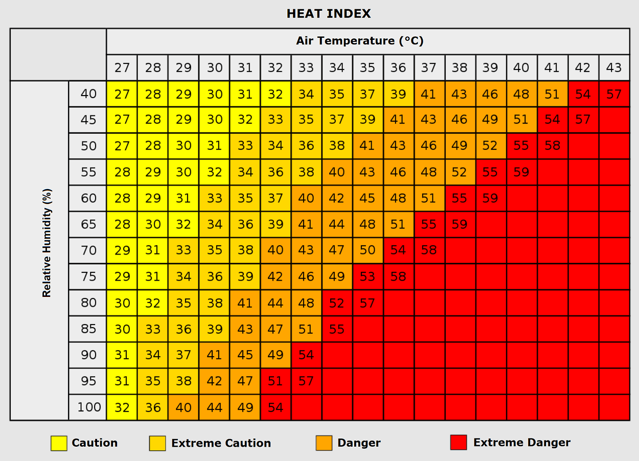
This creates a cumulative effect. Vulnerable populations—the elderly, children, and those with pre-existing cardiovascular or respiratory conditions—are at the highest risk. Hospitals and emergency services are bracing for a surge in heat-related illnesses, including heat exhaustion and heat stroke. Furthermore, the "Heat Index"—the perceived temperature accounting for humidity—is pushing the "feels like" temperature toward 50°C in some regions, a threshold where human survival in prolonged exposure becomes physically difficult.
Implications for Infrastructure and Society
The socio-economic impacts of this fifth heat dome are multifaceted:
Energy Grid Strain
As millions of households and businesses turn to air conditioning to cope with the extreme temperatures, energy demand is skyrocketing. The power grid is under immense pressure to meet this surge while simultaneously managing potential efficiency losses in transmission lines due to the heat.
Urban Heat Island Effect
Metropolitan areas, characterized by concrete, asphalt, and high building density, are acting as thermal batteries. These surfaces absorb heat during the day and release it slowly at night, exacerbating the "tropical night" phenomenon. This underscores the urgent need for urban planning that prioritizes green spaces and reflective materials to mitigate the future impact of such heat domes.
Agriculture and Water Management
With soil moisture already significantly depleted from earlier heatwaves, this fifth event is placing further stress on late-summer crops. Agricultural sectors across the continent are reporting concerns regarding yield reduction and the need for increased irrigation, which in turn places a massive strain on water reserves that are already under scrutiny due to prolonged drought conditions in southern Europe.
Expert Perspectives and Future Outlook
Meteorologists and climatologists are observing these repeated heat domes with growing concern. The frequency of these events in 2026 suggests a shift in the standard summer baseline for Europe. While a "pattern flip" is projected for next week—potentially allowing cooler maritime air to finally penetrate the continent—the damage from this fifth dome will be felt for some time.
Official meteorological agencies across the EU are advising citizens to limit outdoor activity, stay hydrated, and check on elderly neighbors. As we look toward the remainder of the summer, the question for policymakers is no longer whether these heatwaves will occur, but how society can adapt to a future where such extreme thermal events are the rule rather than the exception.
This 2026 season serves as a stark reminder of the volatility inherent in our current climate system. As the heat dome gradually dissipates, the data collected from this event will be critical for researchers to understand the dynamics of high-pressure blocking and its role in shaping the future of European summers. For now, the priority remains the safety of those living under the shadow of this immense atmospheric structure. Stay informed, stay cool, and heed all local emergency directives as the region navigates the final, most intense peak of the summer.