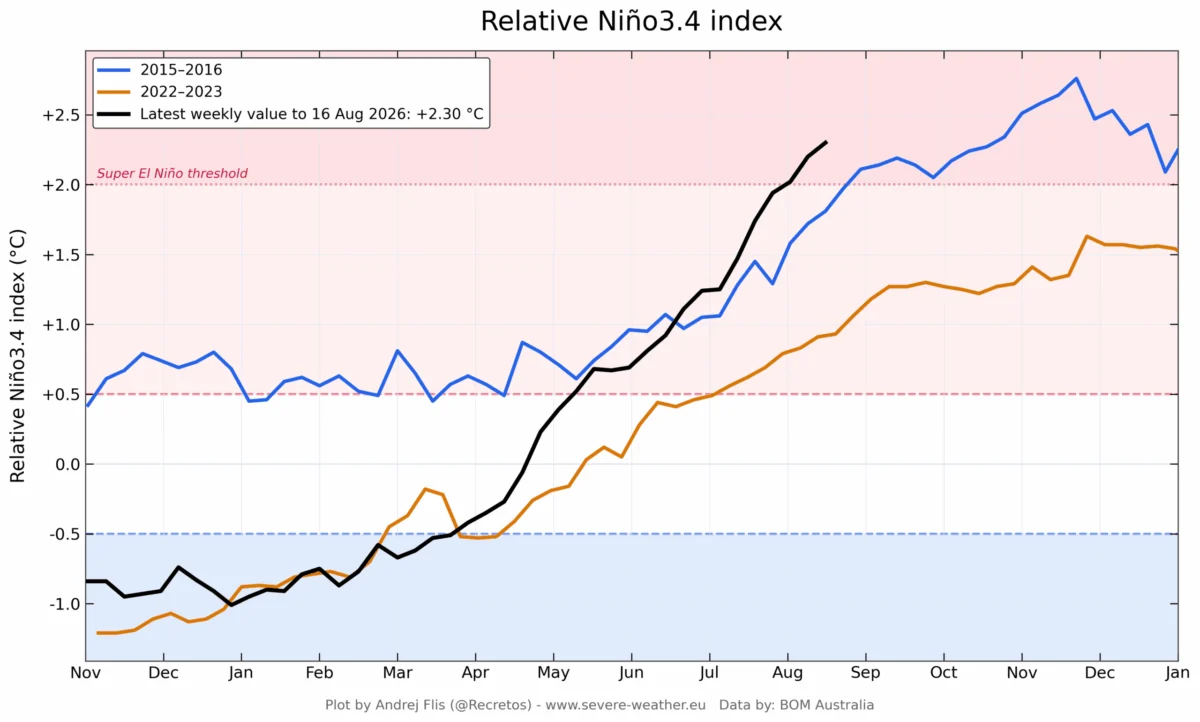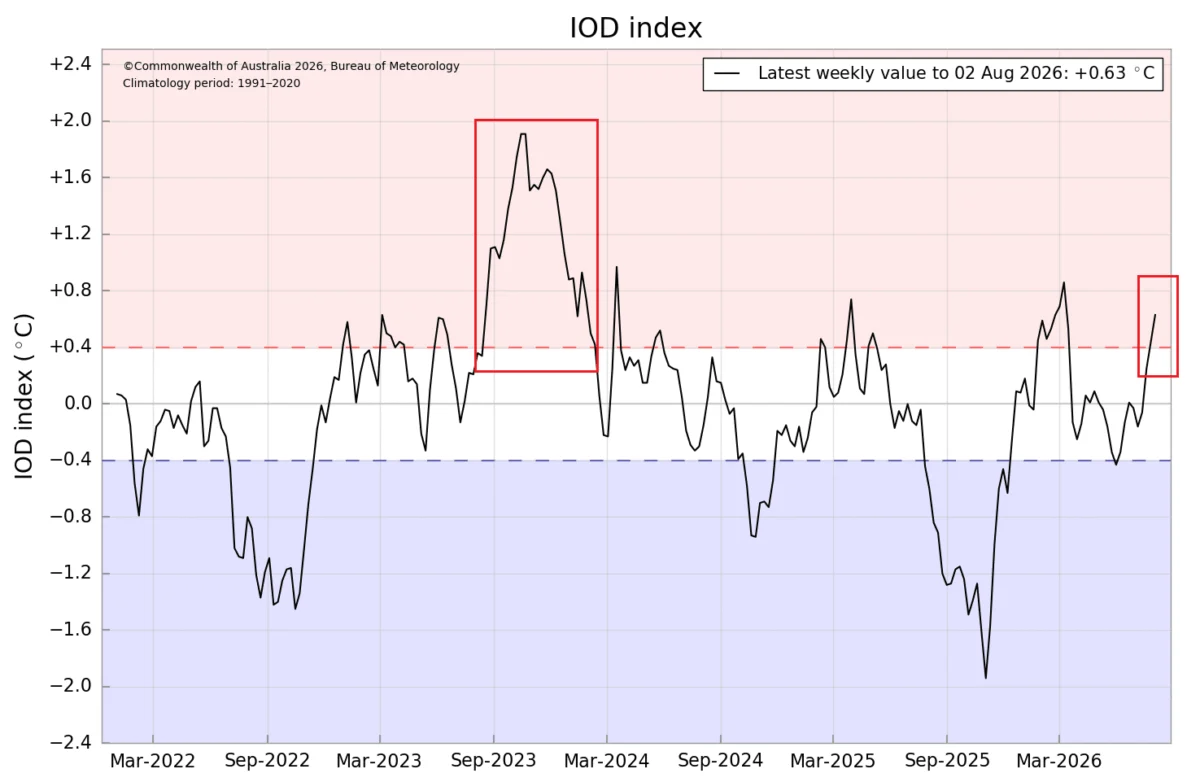
As we move into the latter half of the year, meteorologists are closely monitoring a rare and powerful atmospheric phenomenon: the convergence of a rapidly intensifying Super El Niño and a developing positive Indian Ocean Dipole (IOD). This "dual-ocean" forcing is expected to act as a primary driver for the Northern Hemisphere’s climate patterns throughout the upcoming Winter 2026/2027 season.

The interplay between these two massive ocean-atmospheric systems creates a synchronized global "engine." By altering heat distribution across the tropics, this combination is already influencing jet stream behavior, with significant implications for temperature, precipitation, and snowfall trends across North America and Europe.
Main Facts: A Dual-Ocean Atmospheric System
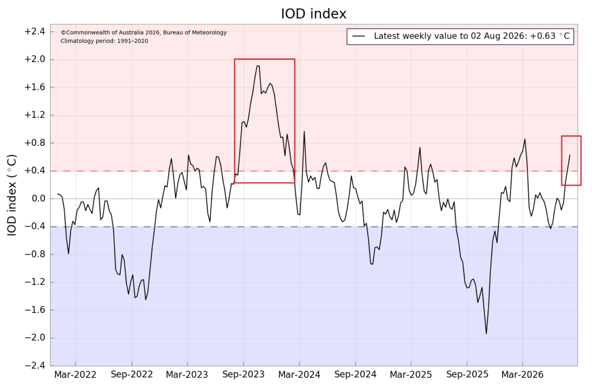
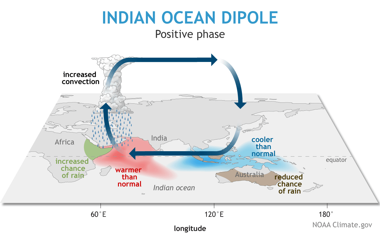
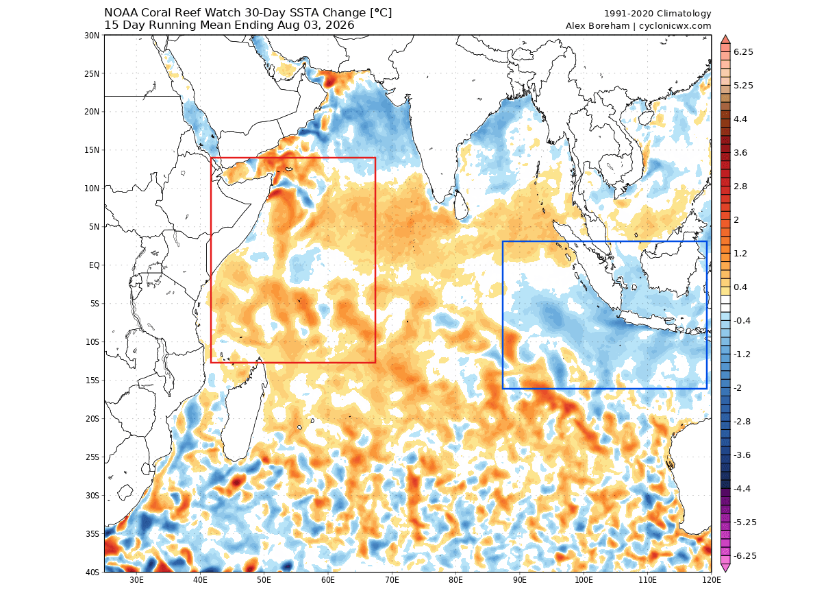
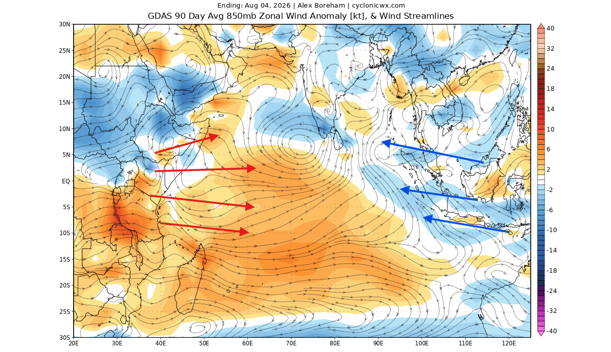
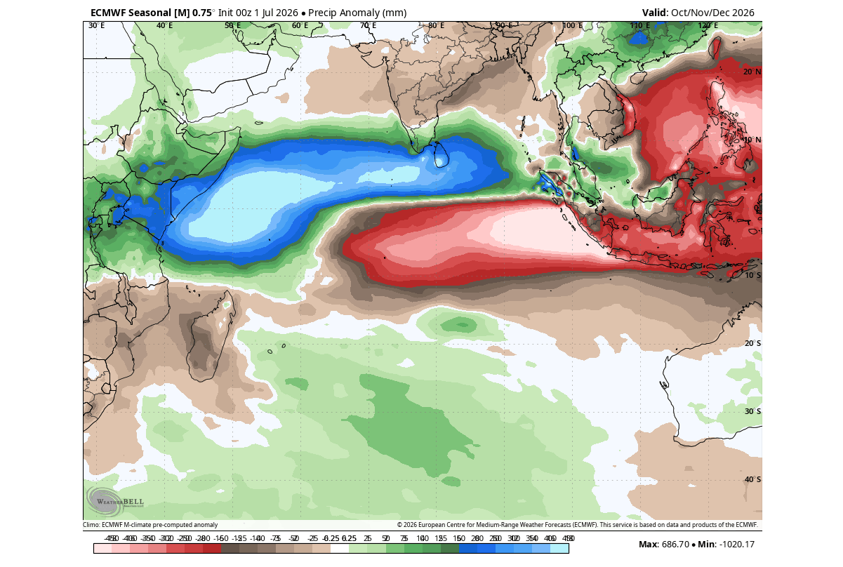
The Indian Ocean Dipole (IOD) is a phenomenon characterized by a temperature imbalance between the eastern and western regions of the Indian Ocean. A positive IOD phase occurs when warmer-than-average waters in the western Indian Ocean contrast with cooler waters in the east, fueled by shifting trade winds.
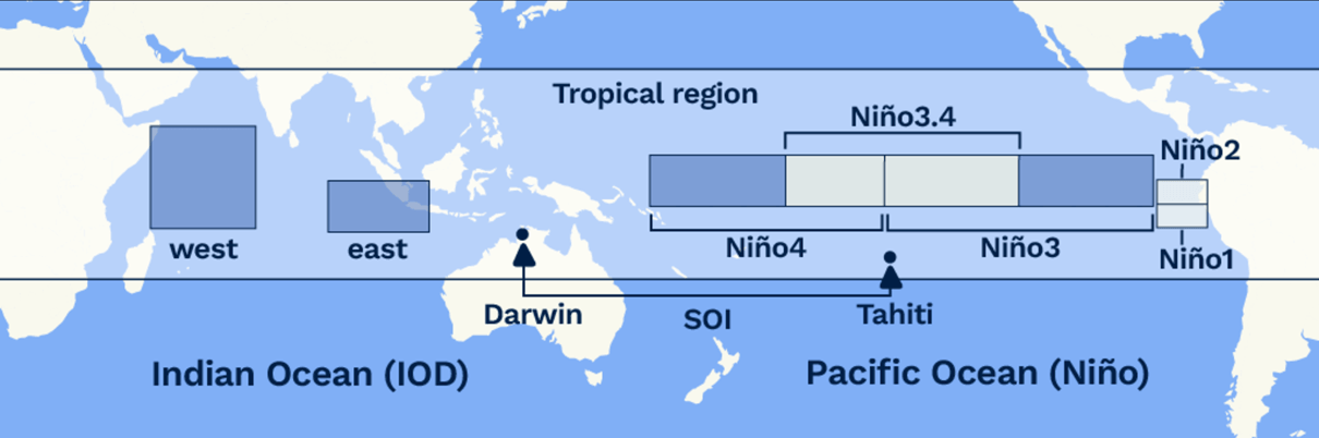
When a positive IOD coincides with a Super El Niño—a significant warming of the central and eastern tropical Pacific—the global weather system enters a state of enhanced connectivity. This is not merely a localized event; it is a fundamental shift in the global circulation. Rising air over the warm Pacific and western Indian Ocean, coupled with sinking air over Indonesia and the eastern Indian Ocean, creates a massive atmospheric cell. This "tropical forcing" launches planetary-scale wave trains that ripple outward, dictating the position of the jet stream and the track of winter storms across the globe.
Chronology of Development
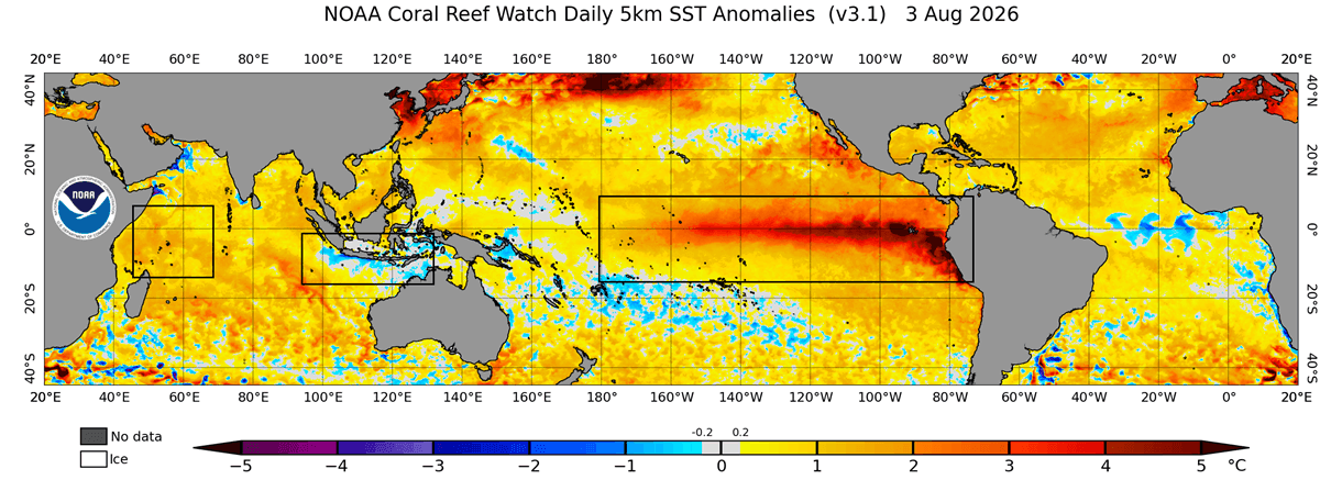
The current climate data indicates that these systems are not merely transitory but are locked into a persistent phase.
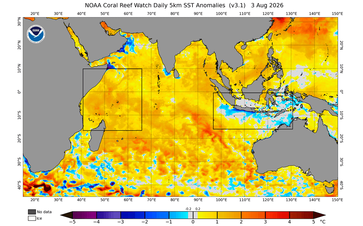
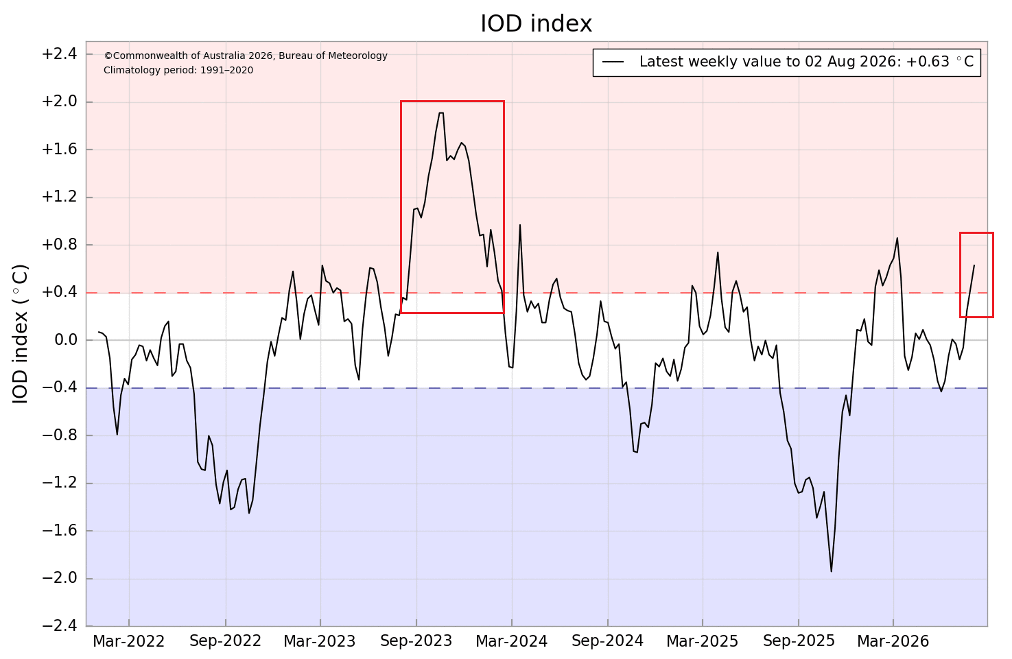
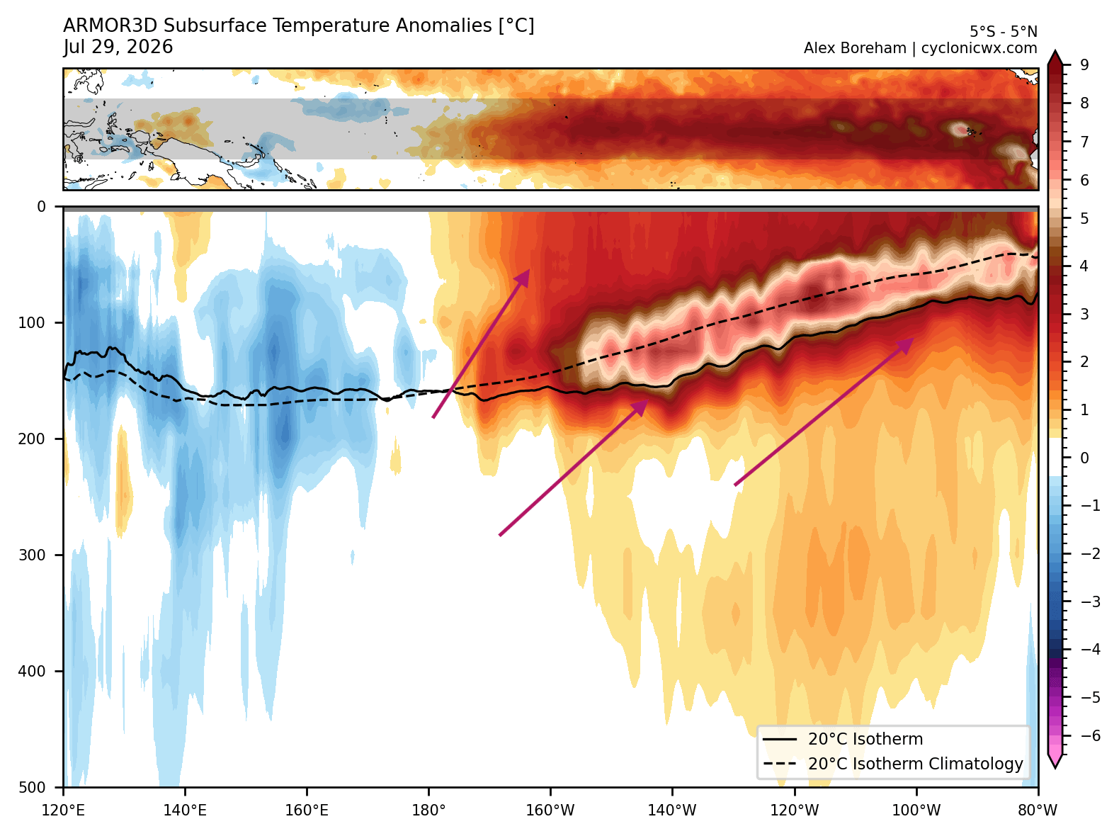
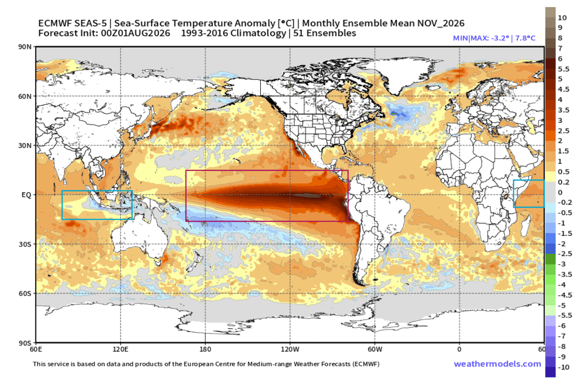
- August 2026: Initial analysis confirms the IOD has entered a sustained positive phase. Simultaneously, the Pacific is seeing subsurface temperatures in the ENSO regions reaching anomalies of +8°C in the core, signaling the rapid rise of a major Kelvin Wave.
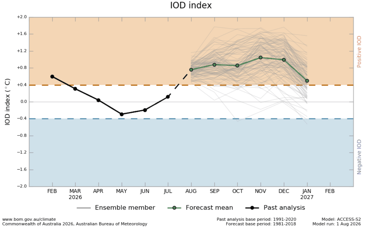
- Fall 2026: Seasonal forecasts project the IOD to persist through the autumnal months. The interaction between this dipole and the deepening Super El Niño is expected to reach a critical threshold, locking in the atmospheric standing wave.
- Early Winter 2026/2027: The combined energy from these two systems is forecast to peak, forcing a high-amplitude "split-flow" jet stream pattern across North America.
- Late Winter 2027: Current modeling suggests that the pressure anomalies will intensify, with the North Pacific jet stream driving persistent, moisture-rich storm tracks across the southern and eastern United States.
Supporting Data and Technical Analysis
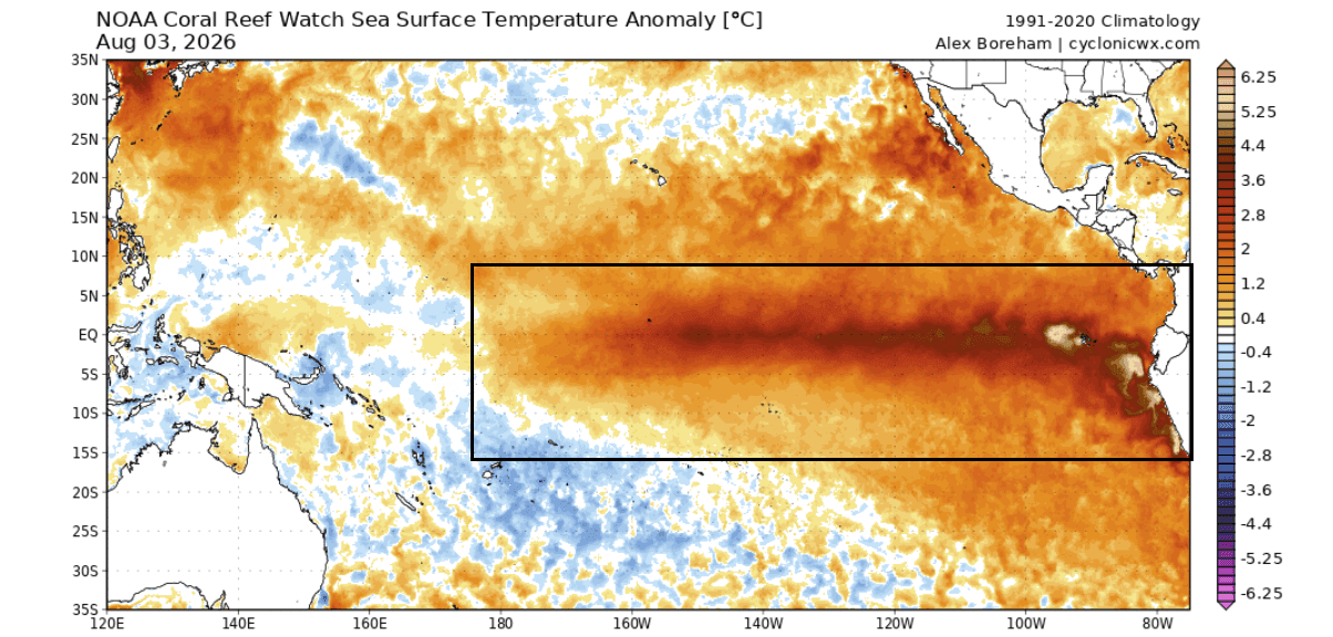
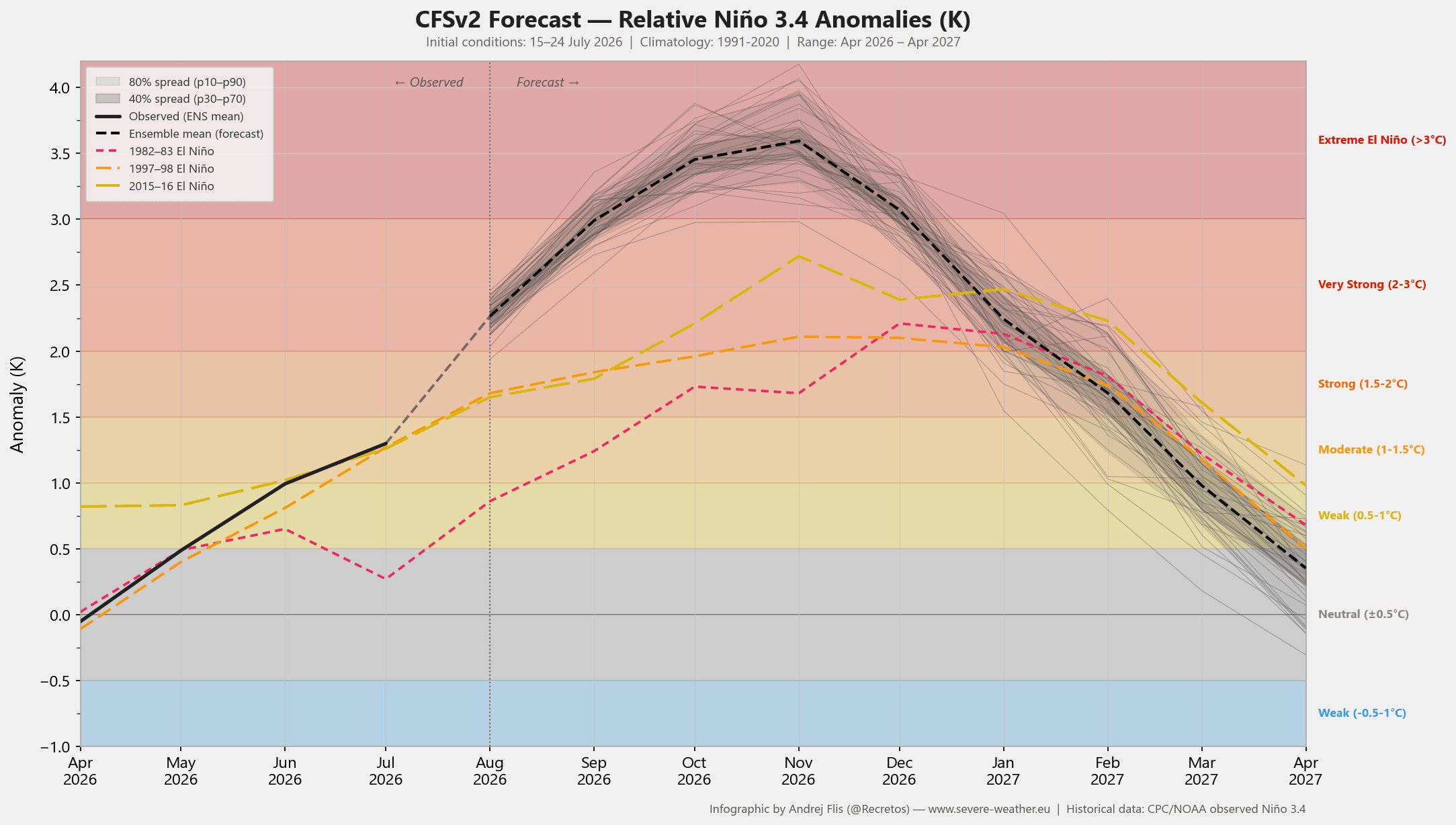
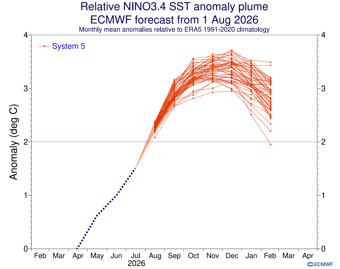
The strength of this event is verified by multi-model consensus, including the ECMWF and NCEP CFSv2. The "heart" of the Super El Niño lies in the subsurface, where a massive Kelvin Wave—a deep pulse of warm water—is moving eastward. As this wave surfaces, it pushes the Pacific sea surface temperatures well into the "Super" threshold, with models consistently projecting peaks exceeding +3°C to +6°C above the seasonal norm.
Atmospheric motion analysis confirms that the "standing wave" is already active. Green anomalies (representing rising air) are dominating the tropical Pacific, while brown anomalies (sinking air) are anchored over the Indian Ocean. This confirms that the global atmosphere is responding to the tropical forcing exactly as theory predicts, effectively setting the stage for a winter season heavily influenced by these oceanic anomalies.
Regional Implications: North America and Europe
The North American Split-Flow
For North America, the forecast points toward a high-amplitude pressure pattern. A persistent high-pressure ridge is expected to anchor over Canada and the northern United States. This "boulder in the stream" will deflect traditional cold-air paths, resulting in milder-than-average conditions for the northern tier of the continent.
Conversely, the southern United States is expected to be the primary battleground for winter activity. The active southern storm track, energized by Pacific moisture, will likely bring above-normal precipitation to Texas, the Gulf Coast, and the Southeast. Where this moisture encounters intermittent cold-air intrusions from the north, the potential for significant winter storms and heavy snowfall increases substantially. The Central Plains, Mid-Atlantic, and interior Northeast are currently identified as the primary zones for higher-than-average snowfall potential.
Europe’s Westerly Dominance
Europe’s climate is less directly impacted by tropical forcing than North America, but it is not immune to the downstream effects of the Pacific jet stream. The combined Super El Niño and IOD are projected to drive an amplified westerly flow into the European continent.
For the December-February period, this suggests a pattern dominated by low-pressure anomalies over northwestern Europe and a high-pressure ridge to the south. The result is a forecast favoring milder temperatures and above-normal precipitation, particularly in the north and northwest. While the overall pattern is not ideal for widespread, sustained snowfall, the mountainous interior and northeastern regions remain vulnerable to periodic, heavy winter events as individual low-pressure systems track inland.
Official Scientific Perspectives and Climate Outlooks
The synchronization of these events is being scrutinized by leading meteorological centers. Climate studies emphasize that while an individual IOD event may only create a "ripple" in the global jet stream, its pairing with a Super El Niño creates an "atmospheric domino effect."
The current consensus is that the atmospheric highway—the wave train—is already in motion. This reduces the uncertainty often associated with long-range forecasting, as the massive energy released by the ocean surface acts as a stabilizer for long-range models. Meteorologists warn that while computer models provide a baseline, the actual intensity of winter storms often exceeds these projections because the atmosphere "feeds" on the available tropical energy with greater efficiency than digital simulations can fully capture.
Conclusion: A Winter of Extremes
The winter of 2026/2027 will be defined by the "Super" nature of these climate drivers. For residents in the southern United States, this likely means a season of frequent, moisture-heavy storm systems. For those in the northern United States and Canada, the outlook leans toward a milder, potentially snow-starved winter, disrupted only by the occasional polar cold snap.
As the system continues to evolve, the global meteorological community remains on high alert. The "tropical engine" is not only a subject of scientific fascination but a harbinger of the logistical and societal challenges that accompany extreme, high-energy weather patterns. Continued monitoring of the jet stream’s response to these dual-ocean anomalies will be essential for accurate localized forecasting as the season progresses.
For the latest updates on this unfolding climate event, refer to seasonal updates from the ECMWF and local meteorological authorities. The coming months will be critical as the atmospheric wave train matures and settles into its final winter alignment.