While Crete is globally celebrated for its sun-drenched Mediterranean beaches and the labyrinthine remnants of Minoan civilization, its interior holds a more primal secret. Towering above the Aegean, the "Lefka Ori"—the White Mountains—form a limestone citadel that dominates the island’s landscape. Carved into this geological masterpiece is the Samaria Gorge, a 16-kilometer (9.9-mile) chasm that stands as one of the most significant natural monuments in Southern Europe.

More than just a hiking destination, the gorge is a symbol of Cretan resilience, a biodiversity hotspot, and an engineering marvel of the natural world. Whether navigated as a standard one-way descent or a grueling round-trip endurance test, Samaria offers a journey through time, terrain, and tradition.

Main Facts: The Anatomy of a National Park
The Samaria Gorge is, by any measure, a premier natural attraction. Measuring 16 km from the Xyloskalo trailhead to the coastal village of Agia Roumeli, it ranks as Europe’s second-longest gorge, trailing only the Verdon Gorge in France.

Key Technical Data
- Distance: 14.5 km (8.9 miles) of primary trail.
- Elevation Profile: A descent of approximately 2,327 m (7,635 ft) combined with an ascent of 1,099 m (4,285 ft).
- Difficulty: While physically demanding due to length and heat, the trail is technically "easy," consisting of well-maintained paths.
- Duration: Average transit time is 5–6 hours.
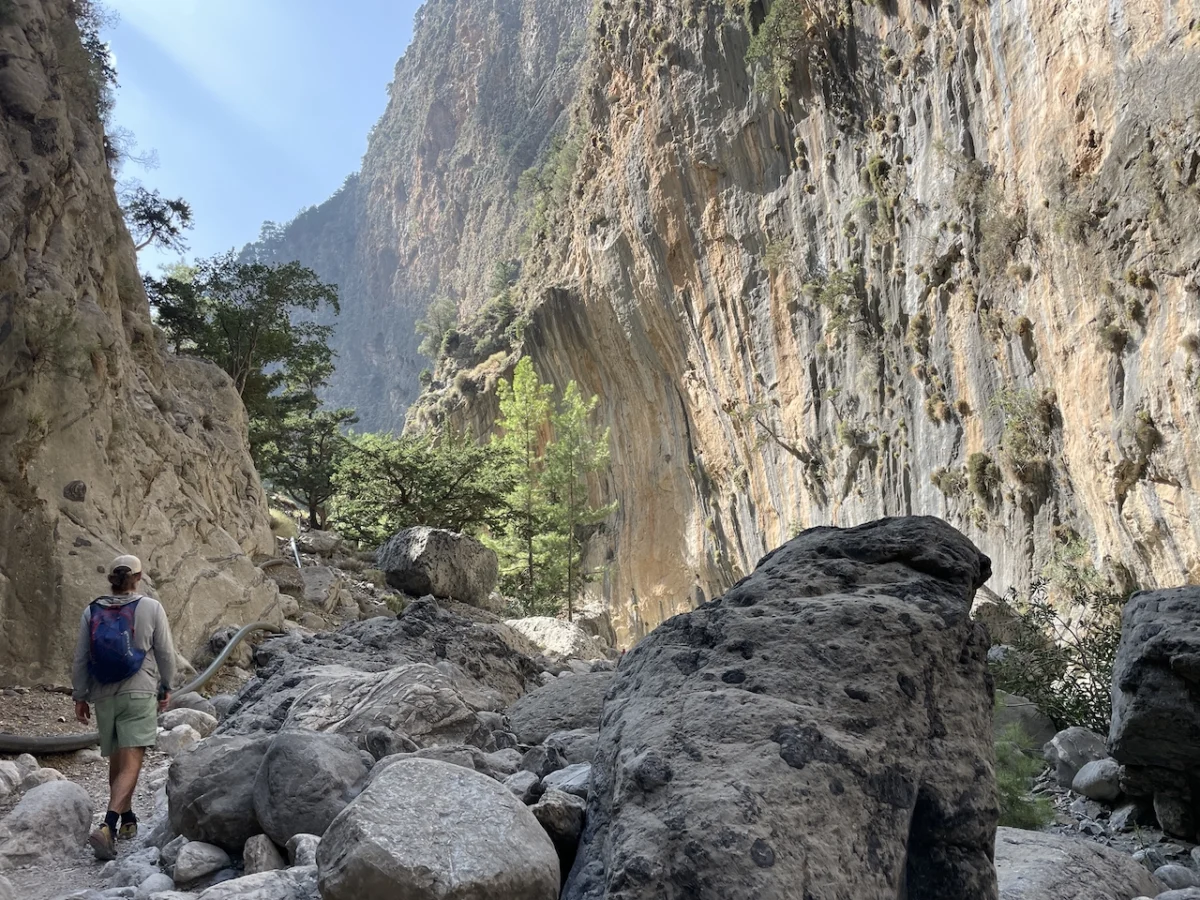
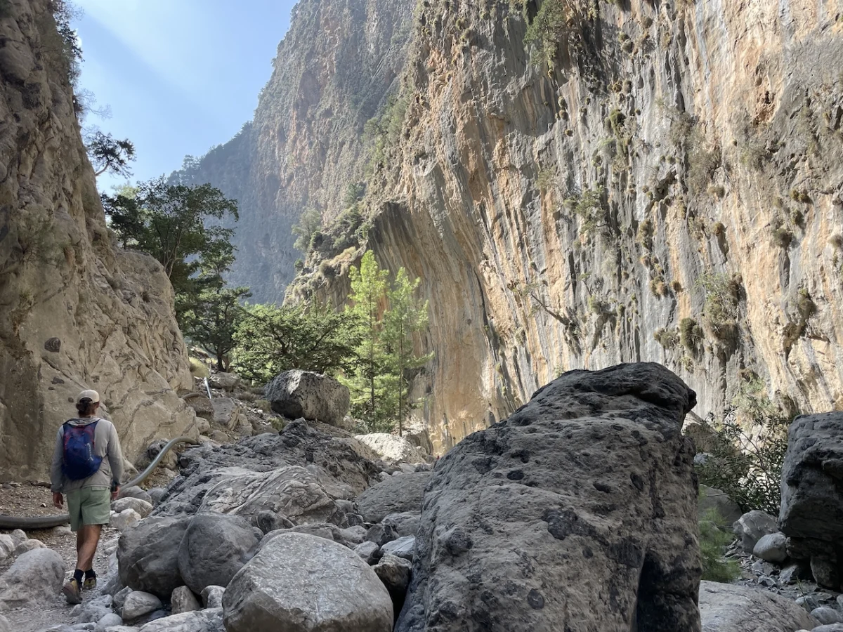
The gorge is characterized by its dramatic verticality; in sections, the limestone walls soar 300 meters (984 ft) toward the sky, narrowing at the "Iron Gates" to a mere three meters in width. This claustrophobic, awe-inspiring passage is the geological heart of the park, a place where the earth seems to have been sliced open by the very forces of the tectonic movements that formed the island.

A Chronology of the Landscape
The history of Samaria is inextricably linked to the history of the Cretan people. During the Byzantine period, the gorge was not a park but a refuge. Its inaccessible geography provided a sanctuary for those fleeing foreign oppression.

From Refuge to National Park
For centuries, the settlement of Samaria—located at the halfway point of the gorge—housed families who farmed the fertile valley floor and sought protection behind the canyon’s unassailable walls. During the Ottoman occupation, particularly in the 18th and 19th centuries, the gorge became a bastion of liberty. The most famous legend tells of 4,000 Cretan women and children who sought safety in the gorge in 1770, defended by the local hero Giannis Bonatos and a small force of 200 fighters. They successfully held the Iron Gates against Ottoman forces, cementing the gorge’s status as a symbol of resistance.

It was not until 1962 that the area was officially designated a National Park. At this juncture, the original residents were resettled, and the village of Samaria was transformed. Today, the stone structures serve as a medical center, a base for forestry staff, and a field station for environmental researchers, ensuring that the human history of the site is preserved even as the park focuses on ecological conservation.

Ecological Significance: The Domain of the Kri-kri
The gorge acts as a critical ecosystem, housing species found nowhere else on earth. The most iconic resident is the Kri-kri (Cretan Goat). These shy, sure-footed ruminants are characterized by their brownish coats, dark dorsal stripes, and magnificent curved horns.

The Conservation Success Story
By the early 1960s, the Kri-kri population had plummeted to roughly 200 individuals, pushing the species to the brink of extinction. The establishment of the National Park was the turning point. By protecting their habitat from hunting and development, the population has rebounded to an estimated 2,500 individuals.

Interestingly, while synonymous with Crete, the Kri-kri are not strictly indigenous; historical evidence suggests they were introduced during the Minoan Civilization (3100–1100 B.C.), as evidenced by their recurring presence in ancient art, coinage, and sealstones of that era.

A Trial of Endurance: The Out-and-Back Experience
While the vast majority of visitors opt for the standard downhill hike—ending with a swim and a ferry ride from Agia Roumeli—the trail can be approached as a grueling out-and-back journey. This presents a unique logistical and physical challenge.

Chronology of an Out-and-Back Attempt
The hike begins at the Xyloskalo ticket office at sunrise. The descent through the switchbacks provides a panoramic view of the White Mountains, named for their snow-capped peaks in winter and the reflective quality of their bald limestone in the warmer months.

- Phase I (0–4 km): The descent to the rest area of Ayios Nikolaos. This site, home to a centuries-old chapel and the tallest cypress trees in Crete, also sits upon the ruins of an ancient temple dedicated to Apollo (1st Century B.C.).
- Phase II (4–7 km): The trail levels out, winding through forest corridors. This is the prime habitat for the Kri-kri.
- Phase III (7–8 km): The halfway point, marked by the village of Samaria.
- Phase IV (8–14.5 km): The transition into the "Iron Gates." This is the most dramatic section of the hike, where the gorge reaches its narrowest point.
Official Responses and Safety Protocols
Because the gorge is a protected National Park, officials are highly vigilant regarding hiker safety and time management. When undertaking a non-standard hike—such as a return trip—hikers often encounter resistance from park authorities.

Park rangers are tasked with ensuring no one is caught inside the canyon after sunset. In a recent instance, hikers attempting an out-and-back journey were met with skepticism by officials at the southern entrance. The standard operating procedure for rangers is to insist on the ferry route, as the physical toll of climbing back up the 1,000+ meters of elevation to the northern entrance is often underestimated by tourists.

However, for experienced hikers who maintain a steady pace, the passage through the park is monitored with a mix of caution and professional respect. Successful completion of such a route requires not only physical fitness but also adherence to the strict 6:00 p.m. exit deadline.

Implications: The Future of Samaria
The Samaria Gorge serves as a blueprint for how tourism and conservation can coexist. By channeling thousands of hikers through a strictly regulated path, the park minimizes human impact on the surrounding wilderness while generating the necessary revenue for the preservation of its Byzantine history and the protection of the Kri-kri.

For the modern traveler, Samaria is a reminder of the raw power of nature. It is a place where one can walk from pine-clad mountains to the sun-drenched Libyan Sea in a single day, passing through millennia of history and geology. Whether you are a casual visitor or an endurance hiker, the gorge demands respect. Its walls, which have sheltered freedom fighters and hidden ancient temples, continue to stand as the silent sentinels of Crete.

Planning Your Visit
- Water: The trail is well-supplied with potable water sources throughout the length of the gorge.
- Seasonality: The park is typically open from May through October, depending on weather conditions.
- Gear: Sturdy footwear is essential, as the terrain is rocky and uneven.
- Cultural Context: For those looking to dive deeper, the Samaria Gorge is featured extensively in literature regarding Mediterranean trekking, including the Wanderlust Mediterranean series, which documents the trail as a premier example of European natural heritage.
As the sun sets over the White Mountains and the last hikers board the ferry at Agia Roumeli, the silence returns to the gorge. It is a place that feels eternal, a deep, limestone-lined vein of history that remains the beating heart of Cretan identity.