The global climate system is currently undergoing a significant shift as a powerful Super El Niño rapidly develops in the tropical Pacific. Meteorological data from across the globe confirms that this event is not merely a standard oscillation but a climate driver of rare intensity, with atmospheric responses already reshaping weather patterns across North America and beginning to exert influence over Europe. As ocean temperatures in the equatorial Pacific continue to climb, meteorologists are bracing for a period of extreme, high-impact weather that will likely dominate the 2026/2027 season.

Main Facts: A Climate Force in the Making
At the heart of this atmospheric transition is the El Niño-Southern Oscillation (ENSO), a periodic fluctuation in sea surface temperatures and air pressure across the equatorial Pacific. We are currently witnessing the birth of a "Super" event—a classification reserved for episodes where sea surface temperature anomalies exceed the +2.0°C threshold.
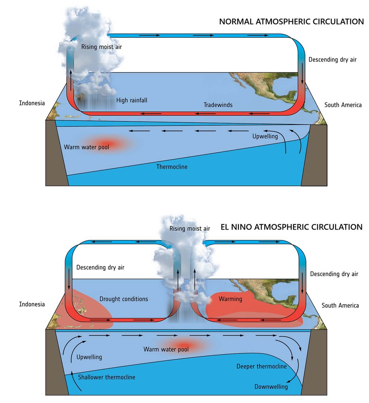
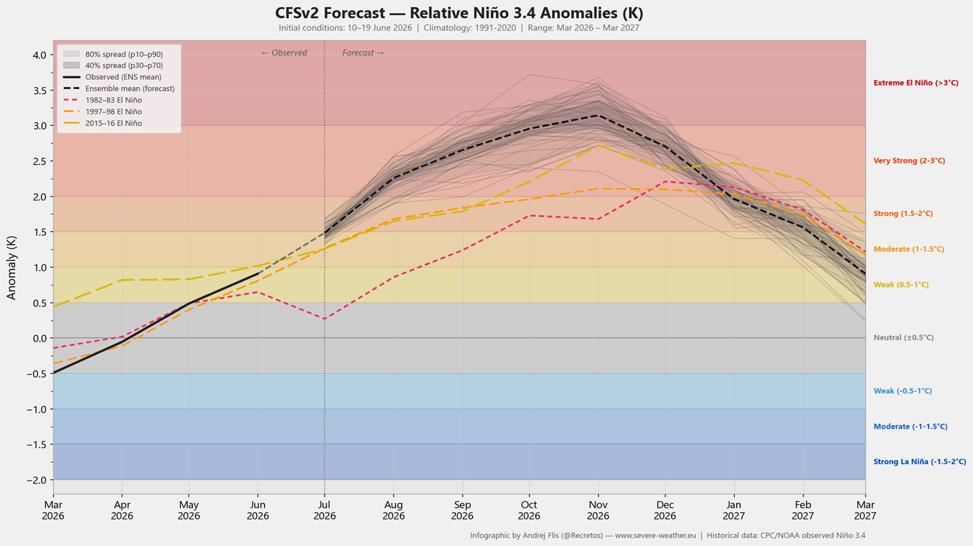
Latest data from the NCEP CFSv2 model indicates that this specific El Niño is trending toward record-breaking intensity, with projections suggesting anomalies could peak between +4°C and +5°C by late winter. Unlike minor events, a Super El Niño acts as a massive atmospheric engine, altering the "Walker Cell"—the primary circulation pattern of the tropical atmosphere. This "atmospheric bridge" creates a ripple effect that dictates jet stream behavior, precipitation distribution, and temperature extremes across the Northern Hemisphere.
Chronology of Development: From Subsurface to Surface
The current event did not manifest overnight. Its origins lie in the deep ocean, where strong westerly wind bursts in the Pacific triggered a massive underwater feature known as a "Kelvin Wave." These waves are essentially packets of warm water that travel eastward along the equator beneath the surface.
- Spring 2026: Early detection of subsurface warming signaled the impending breakdown of neutral conditions.
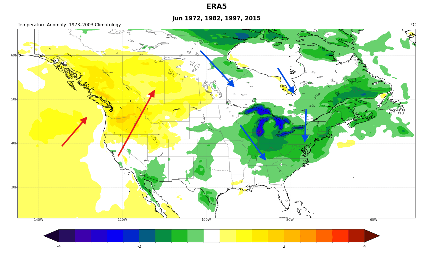
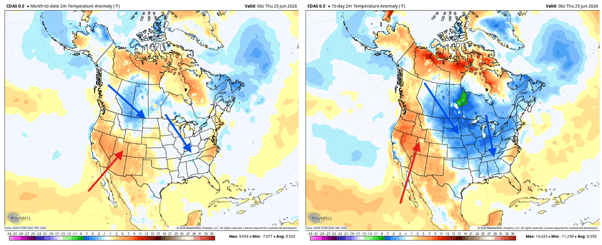
- June 2026: The Kelvin Wave reached the surface, manifesting as a sharp rise in sea surface temperatures. Atmospheric pressure anomalies began to align with historical Super El Niño signatures, specifically causing a shift in the jet stream that favored cooler-than-normal temperatures across parts of eastern Canada and the central/eastern United States.
- July 2026: We are currently observing the "deepening" phase. Atmospheric modeling confirms that the Pacific is now effectively "locked" into an El Niño state, with the global circulation beginning to respond to the massive thermal anomaly in the ocean.
- Late Summer/Fall 2026: Projections indicate the atmospheric influence will broaden, with the "atmospheric bridge" extending its reach, impacting weather systems in Europe and throughout North America.
Supporting Data: Scientific Analysis and Modeling
The evidence for this Super El Niño is robust, derived from multiple independent meteorological datasets.
Ocean Surface Anomalies
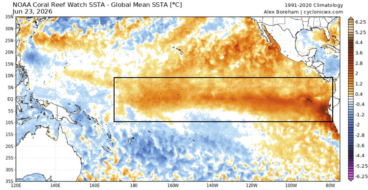
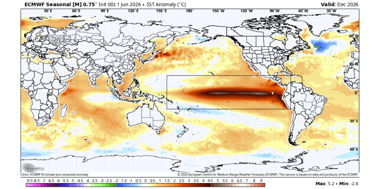
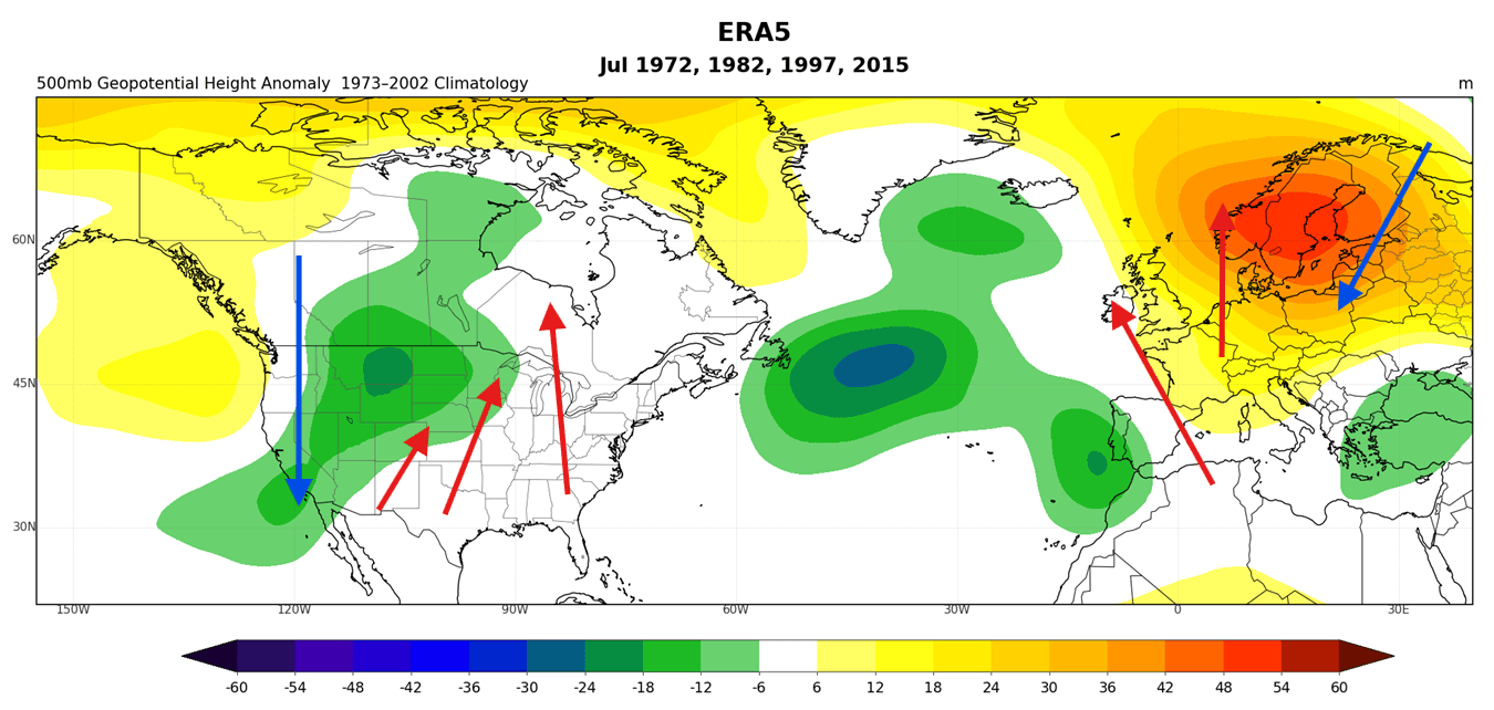
Current ocean analysis—with the global average temperature anomaly removed to isolate the El Niño signal—reveals a growing, concentrated pool of heat in the central and eastern Pacific. This signature is strikingly similar to the most intense El Niño events on record, such as those observed in 1982, 1997, and 2015.
Velocity Potential and Atmospheric Motion
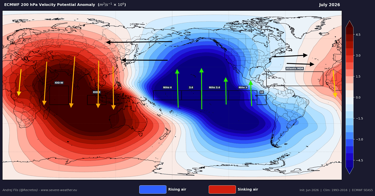
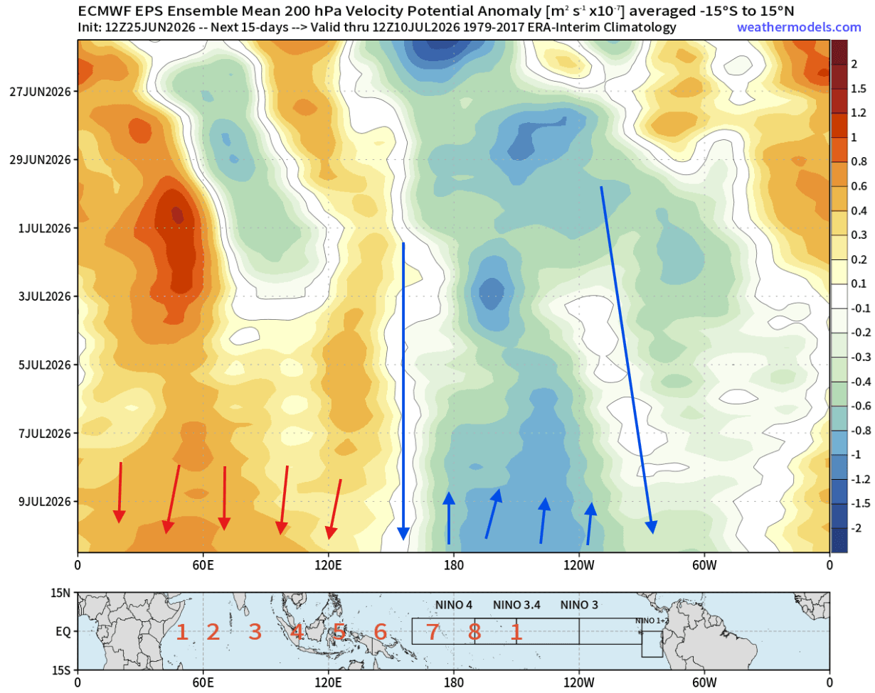
By analyzing the Velocity Potential at the 200mb level (approximately 12km in altitude), scientists can visualize the rising and sinking air patterns that characterize global circulation. The latest ECMWF (European Centre for Medium-Range Weather Forecasts) data shows intense rising air over the central and eastern Pacific, coupled with sinking air over the Indian Ocean. This configuration is the "smoking gun" of a mature, powerful El Niño, confirming that the ocean is successfully communicating its thermal state to the atmosphere.
Pressure Pattern Shifts
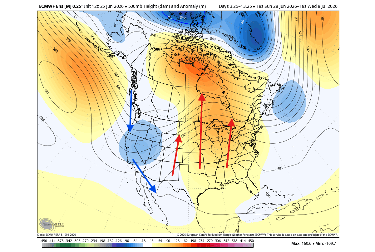
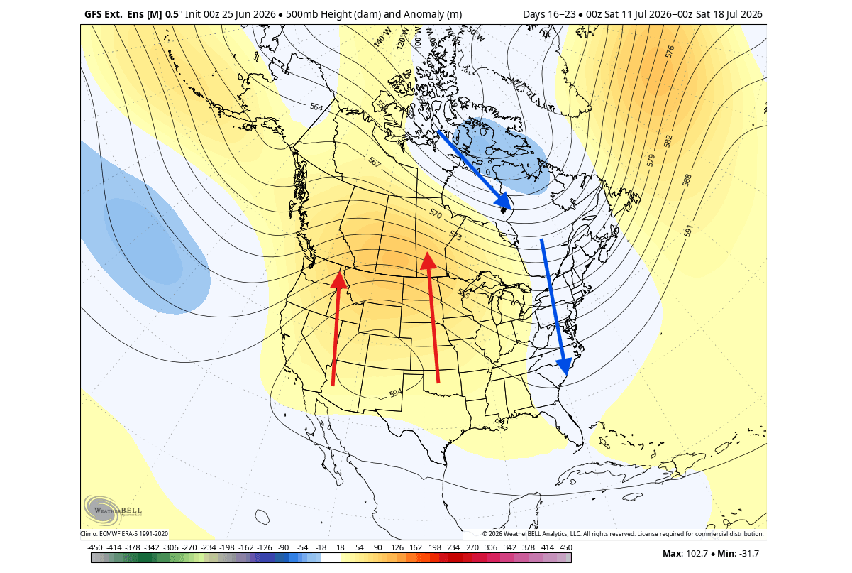
The July forecast shows a dynamic "ping-pong" effect in the pressure systems over North America. While early July saw a high-pressure ridge building over the central and eastern United States, the long-range ensemble forecasts suggest a shift toward a persistent low-pressure influence over the western U.S. and eastern Canada by late summer. This erratic but systematic movement is a hallmark of an atmosphere attempting to adjust to a massive, stationary heat source in the Pacific.
Official Responses and Long-Range Outlooks
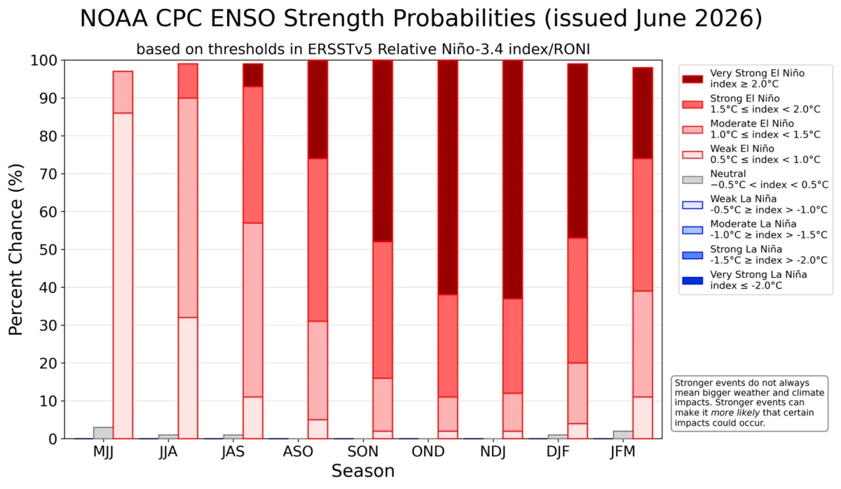
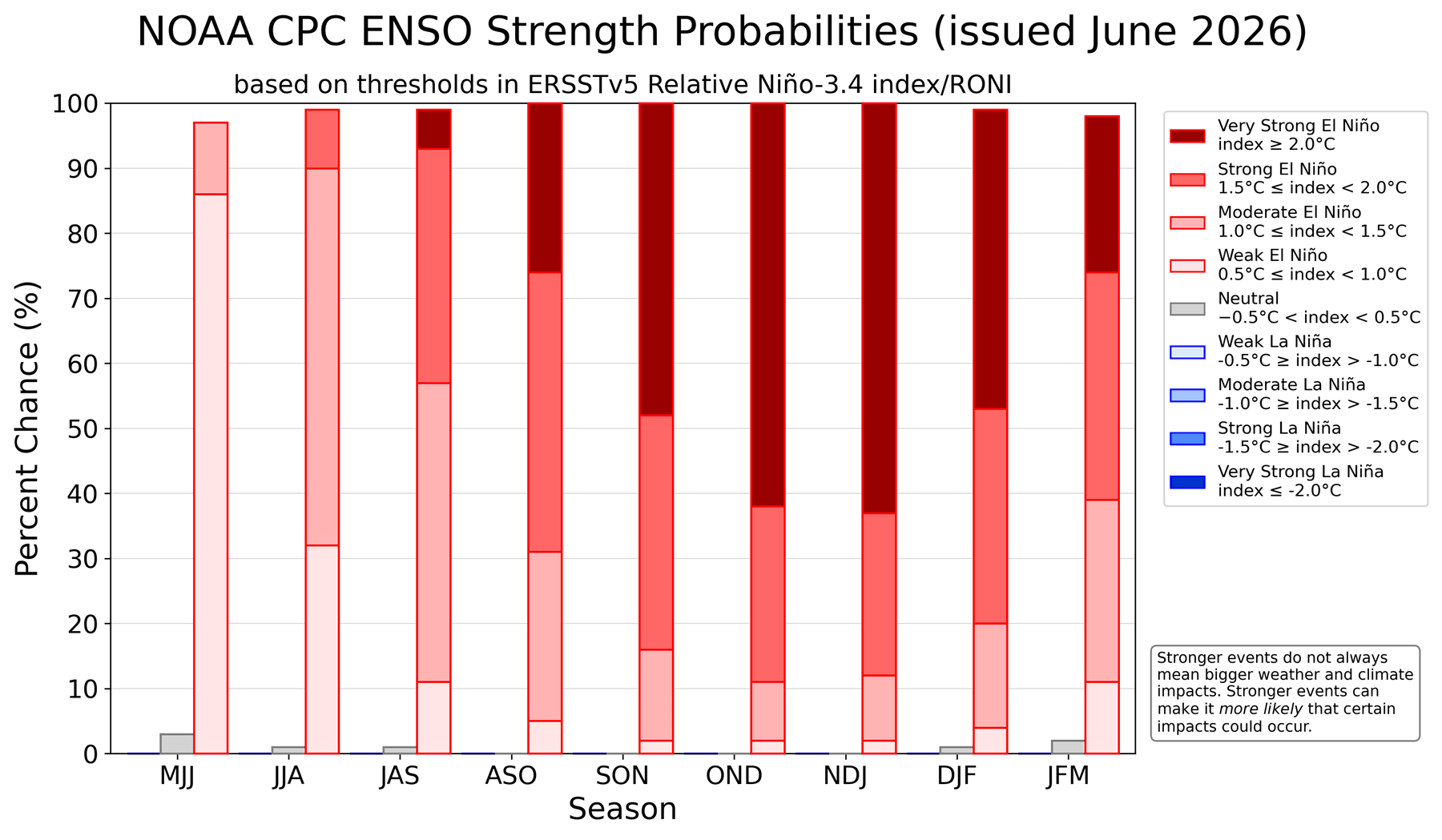
Leading institutions, including the National Oceanic and Atmospheric Administration (NOAA) and the Climate Prediction Center (CPC), have been tracking the probability of this event with increasing concern. The probability of a "Super" event peaking in late Fall or early Winter is currently at its highest level in years.
Official climate models are now extending their reach into December 2026, consistently forecasting significant ocean temperature anomalies that remain well above the +5°C threshold. This indicates that the event will not fade quickly; instead, it is expected to sustain its influence well into the next calendar year, potentially impacting agricultural cycles, energy demand, and disaster management protocols on a global scale.
Implications for North America and Europe
The implications of a Super El Niño are vast, often amplifying seasonal norms into extreme weather events.
North America: Heat, Drought, and Jet Stream Shifts
For the United States and Canada, the emerging pattern suggests a "lockdown" of the atmosphere. We anticipate:
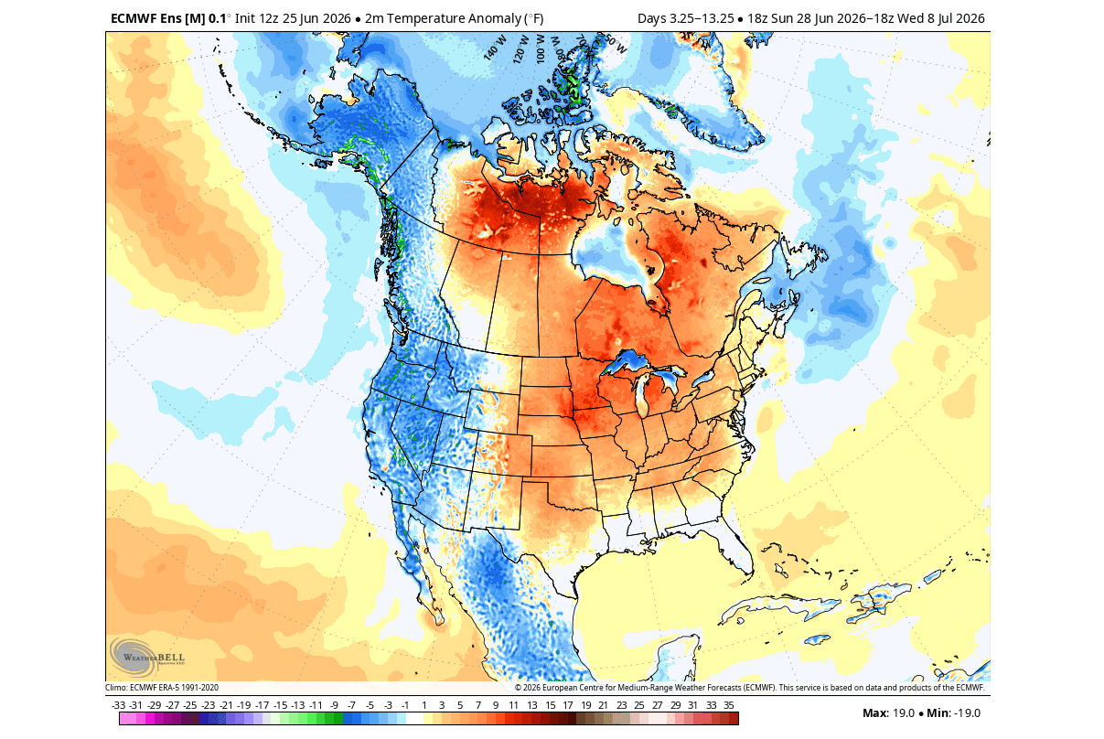
- Central and Eastern U.S./Canada: Expect persistent high-pressure ridges that will likely bring extended periods of warmer-than-average temperatures.
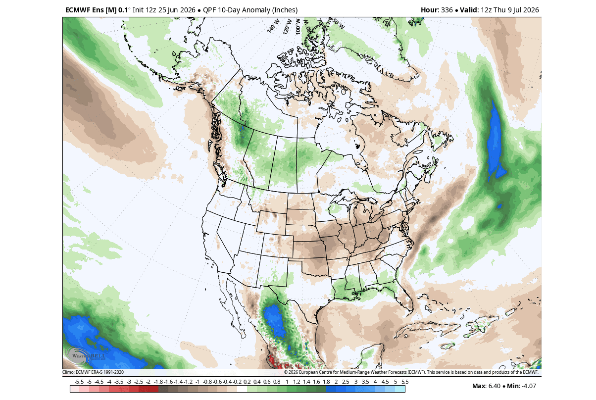
- Western and Northeastern Regions: These areas may see more frequent "undercutting" by low-pressure systems, leading to increased precipitation and, in some cases, severe storm activity.
- Precipitation Variability: While the Midwest and Plains may face drier-than-normal conditions due to high pressure, the southern United States is expected to see increased rainfall as the Pacific jet stream strengthens and tracks further south.
Europe: The Fall and Winter Grip
While Europe is further removed from the Pacific, the atmospheric bridge is expected to make its presence felt by autumn. Historical analysis of Super El Niño years shows a distinct "Rex-block" pattern—a high-pressure system sitting over northern and north-central Europe, causing a significant deviation from normal weather.
As we head into Fall, this blocking pattern will likely result in a split between the northern half of the continent (which may experience anomalous warmth under the high-pressure block) and the southern half (which may face wetter, cooler, and potentially unstable conditions). This configuration is expected to persist through the winter, potentially altering the traditional storm tracks that define European winter weather.
Conclusion: Preparing for the Unpredictable
The rapid development of the 2026-2027 Super El Niño represents one of the most significant climate events of the decade. Its ability to "lock" atmospheric patterns means that the weather we experience over the coming months will likely be less variable and more extreme than in standard years.
From the shifting jet streams over North America to the emerging blocking patterns over Europe, the influence of the Pacific Ocean is undeniable. As we transition deeper into summer and toward the critical fall season, the global scientific community will continue to refine these models. For the public, this serves as a critical reminder that while the Pacific is thousands of miles away, its thermal energy dictates the conditions of our daily lives. Staying informed, monitoring local forecasts, and preparing for increased weather volatility will be essential as this Super El Niño matures into its full, historic strength.