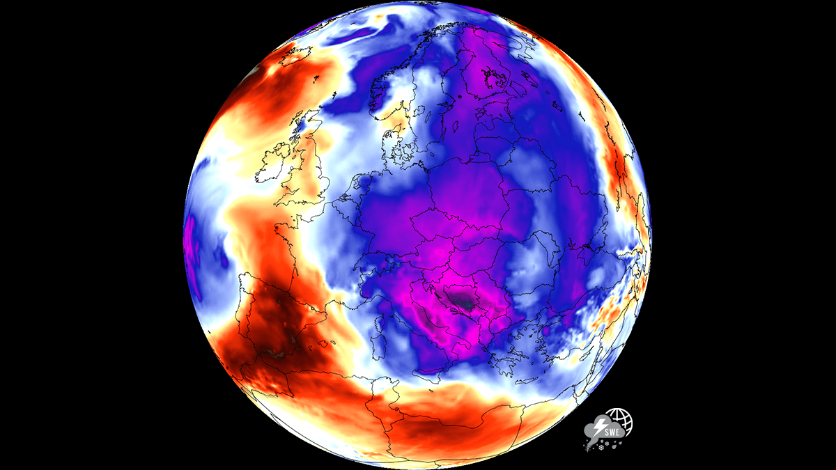
After enduring a relentless and historically significant stretch of extreme heat that gripped the continent, a welcome atmospheric shift is finally delivering a much-needed cooling trend to the eastern half of Europe. Central Europe and the Balkan Peninsula, which have spent the better part of July struggling under the weight of intense heat stress, urban heat islands, and exhausting "tropical nights," are at last seeing a significant temperature downturn.
This transition marks a pivotal moment for millions of residents, offering a brief, vital respite from the sweltering conditions that have defined the summer of 2026. However, while the air may feel more comfortable, the meteorological implications of this shift are complex, bringing both relief and new environmental challenges.
The Meteorological Driver: A Shift in Upper-Level Flow
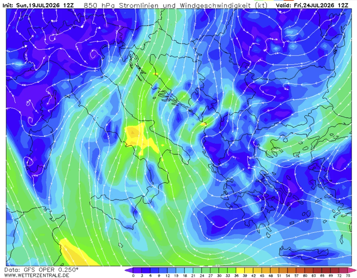
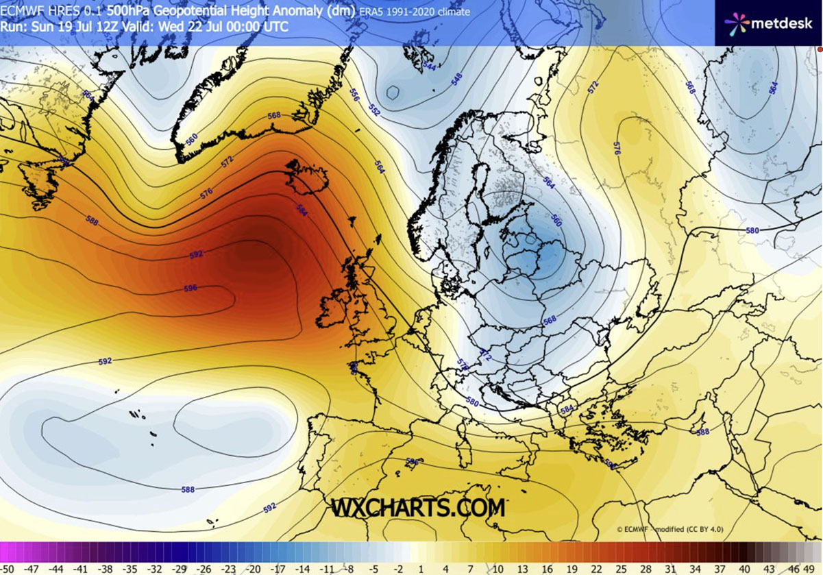
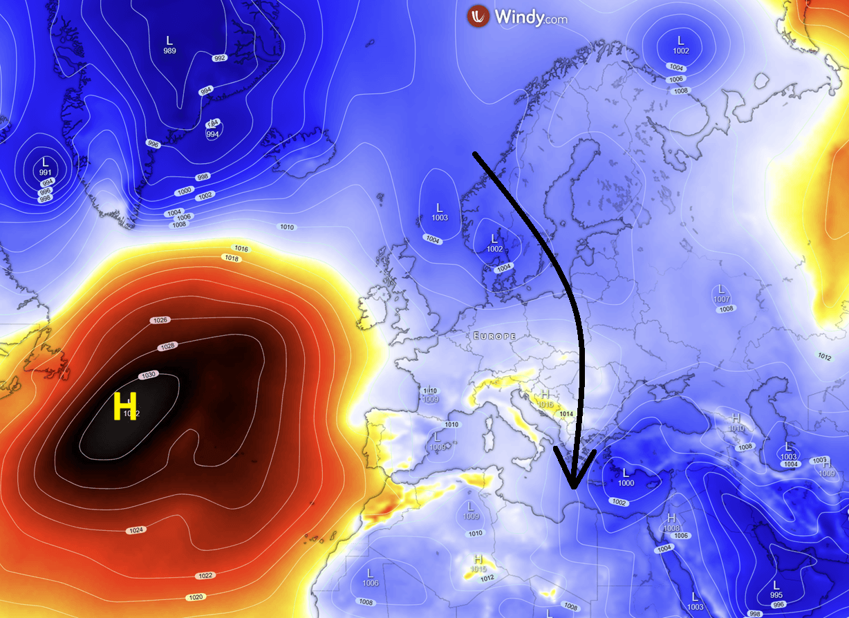
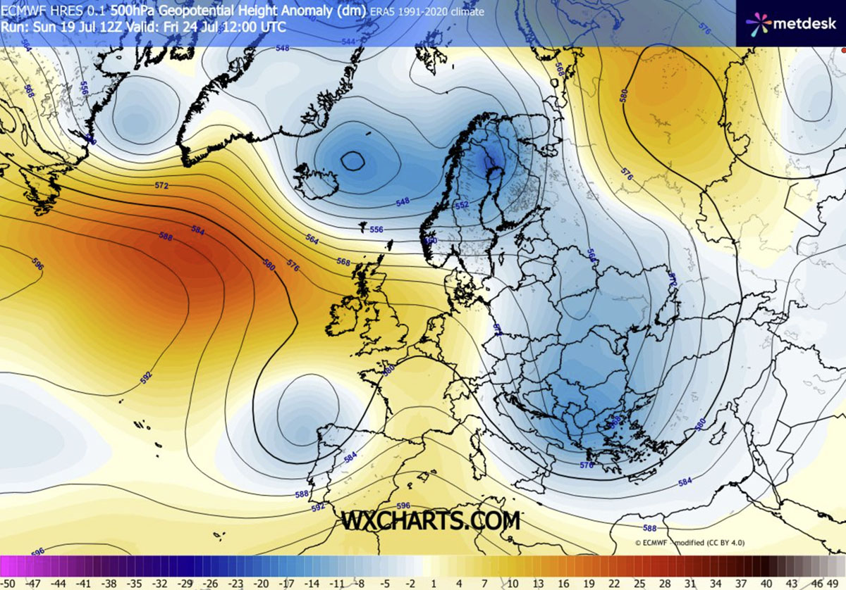
The driving mechanism behind this sudden reversal is a profound restructuring of the continent’s upper-level pressure systems. A strengthening high-pressure ridge over the Atlantic has created a "blocking" pattern, which has effectively opened the door for a large, deep-seated cold wave to descend from the far north.
As the ridge pushes northward, it allows a cold, unstable air mass to spill southward, engulfing Central and Eastern Europe. This shift from a zonal flow to a more meridional—or north-to-south—pattern is forcing temperatures to plummet by 4 to 8°C below seasonal averages. This cold core is expected to remain entrenched through the end of the week, effectively flushing the stagnant, heated air out of the region.
Chronology of the Cold Wave: A Week of Transition
The progression of this weather system is set to occur in distinct phases, affecting different regions with varying levels of intensity.
Mid-Week: The Initial Descent
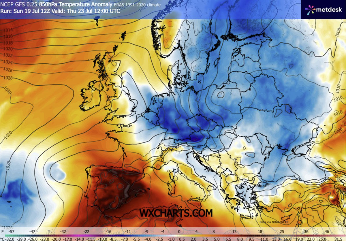
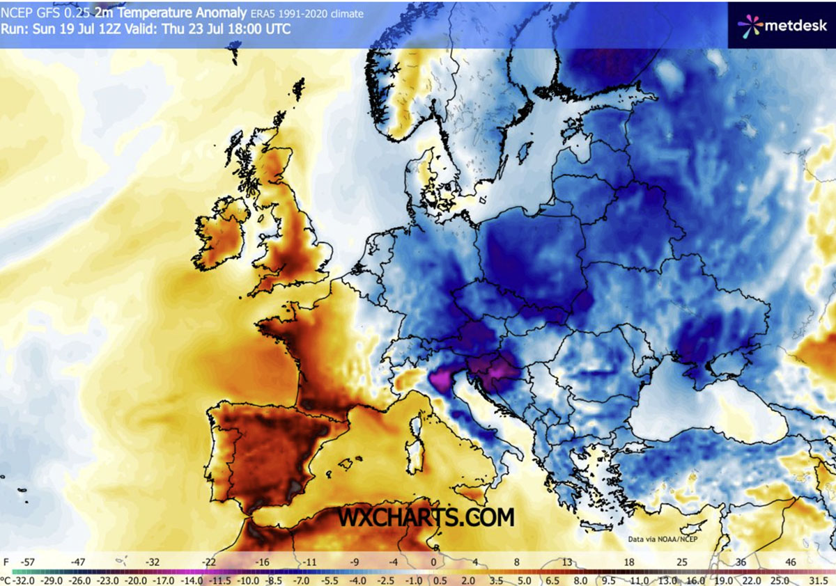
By Wednesday and Thursday, the leading edge of the cold front will have swept across Poland, Hungary, Romania, and parts of the northern Balkans. Residents in these areas are already noticing a stark decline in daytime temperatures, which are falling from the dangerous mid-30s into the comfortable, seasonable low-to-mid 20s. The arrival of this air mass is being marked by brisk, gusty winds, which are accelerating the cooling process and providing a noticeable drop in humidity.
The Weekend Peak: Southern Penetration
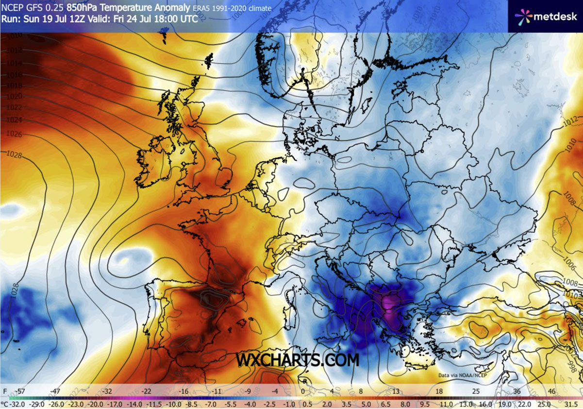
As we head into Friday and Saturday, the core of the cold wave is projected to push further south, reaching the southern Balkans, the Ionian Sea, and Greece. Meteorologists are tracking temperature anomalies of 10–12°C below normal in the lower atmosphere for these regions—a truly remarkable shift for the end of July. While the rest of the world braces for the peak of summer, these areas will experience a cool, refreshing weekend that stands in stark contrast to the blistering conditions of previous weeks.
Persistence of the Pattern
Due to the persistent nature of the Atlantic blocking, this cool-down is not merely a "blip" in the data. The cold wave is expected to maintain its influence throughout the following weekend. While the far southwestern reaches of Europe, particularly the Iberian Peninsula, will continue to experience extreme heat, the eastern and central corridors will enjoy a sustained period of autumnal-like weather.
Supporting Data: Understanding the Thermal Anomaly
The severity of the recent heatwave is best understood through the lens of the data currently being analyzed by climate researchers.
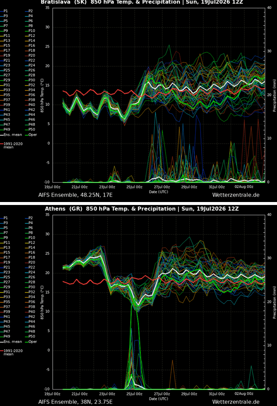
- Surface Temperature Anomalies: On Thursday, the most significant drops are being recorded across northern Italy, Slovenia, Croatia, Austria, Czechia, and Slovakia. These regions are shifting from heat-stress territory to sub-average conditions in less than 48 hours.
- Nighttime Cooling: Perhaps the most significant relief for urban populations is the drop in nighttime temperatures. After weeks of "tropical nights"—where temperatures failed to drop below 20°C—many regions will see thermometers dip into the low to mid-10s. This provides a much-needed opportunity for buildings and infrastructure, which have been "heat-soaked" for weeks, to finally shed their stored thermal energy.
- Wind and Pressure: The pressure gradient between the high-pressure ridge in the west and the developing trough in the east is fueling higher-than-average wind speeds. While these winds are essential for the cooling effect, they serve as a double-edged sword regarding regional fire safety.
Environmental Implications and Risks
While the drop in temperature is a relief for public health, it is not without its hazards.
The Thunderstorm Factor
As the cold, dense air mass collides with the lingering heat and moisture over the Mediterranean and the southern Balkans, the atmospheric instability is increasing rapidly. This interaction is triggering scattered, intense thunderstorms. While these storms provide some localized drought relief, the quick, heavy downpours are often not enough to penetrate the hard-baked, parched soil created by the recent heatwave.
The Continued Wildfire Threat
A critical concern remains the wildfire risk. Despite the cooler temperatures, the combination of dry, gusty winds and vegetation that has been desiccated by weeks of extreme heat means that the threat of wildfires remains at an "extreme" level. Fire departments across Eastern Europe and the Balkans remain on high alert, as the cooling trend does not instantly reverse the fire-prone state of the landscape.
Regional Disparities: A Tale of Two Europes
It is important to note that this "cool-down" is not a continental phenomenon. Europe is currently divided. While the east and center of the continent breathe a sigh of relief, the Iberian Peninsula is locked in a separate, more dangerous weather pattern. Spain and Portugal are continuing to record temperatures in the 40s, as the Atlantic ridge effectively isolates them from the cooling influence of the northern air mass. Meteorologists are continuing to monitor the situation in the southwest, where the heat shows no signs of breaking in the immediate future.
Conclusion: A Vital Pause
For the millions of people living from the Baltic Sea to the Greek islands, this week represents a crucial reset. The ability to lower the internal temperature of homes, schools, and hospitals is essential for public health, as sustained heat stress has cumulative effects on human physiology.
As this weather pattern evolves, the focus of emergency management shifts from heatstroke prevention to monitoring for flash flooding—a common side effect of cold fronts clashing with lingering heat—and maintaining vigilance against wildfires in the still-dry forests of the region.
This week serves as a stark reminder of the volatile nature of our current climate, where extreme swings in temperature are becoming more frequent. For now, the residents of Central and Eastern Europe will welcome the cool breeze, the crisp mornings, and the opportunity to sleep without the oppressive weight of a heatwave, even as the global climate conversation continues to evolve.
Stay tuned to our upcoming reports for an in-depth analysis of the ongoing extreme heat in the Iberian Peninsula and the broader implications of these shifting atmospheric patterns as we move into August.