By Mika Rantanen
Published: August 20, 2026
In the summer of 2026, the traditional narrative of a Finnish summer—defined by long, lazy heatwaves—has been dramatically rewritten by the sound of thunder and the relentless drumming of torrential rain. While many associate the "extreme" label with record-breaking temperatures, the most significant meteorological events of this season have been defined by water. From bridge collapses to inundated urban centers, extreme precipitation has moved from a rare statistical curiosity to a recurring seasonal hazard.
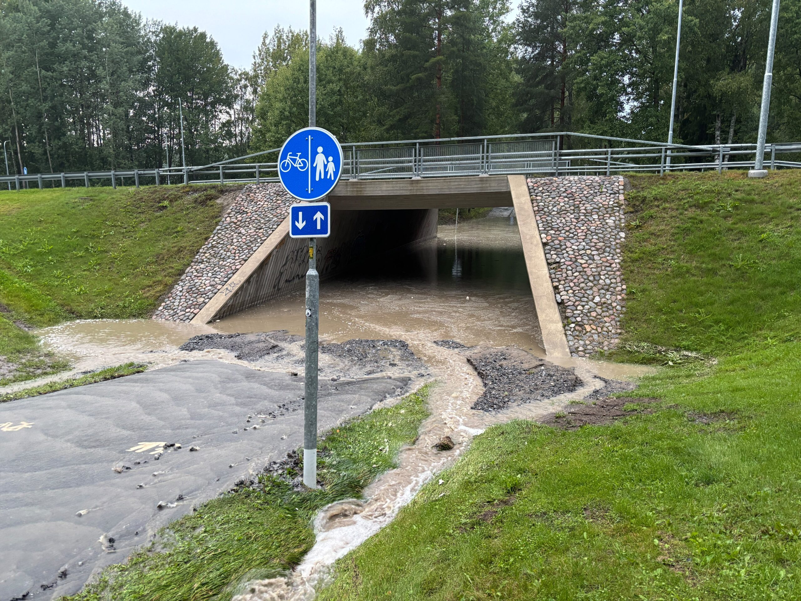
The most recent demonstration of this atmospheric volatility occurred in mid-August in Seinäjoki, where a single, localized weather system triggered devastating flash floods. Similar scenes of waterlogged streets and overwhelmed drainage systems were mirrored in Tampere, highlighting that the nation’s infrastructure is increasingly struggling to cope with the intensity of modern rainfall.
The Anatomy of an Extreme Event
To understand the severity of these events, one must look at the threshold of "extreme." The Finnish Meteorological Institute (FMI) issues a yellow weather warning—the lowest level—when hourly rainfall reaches 20 millimeters or when 24-hour accumulations hit 50 millimeters.
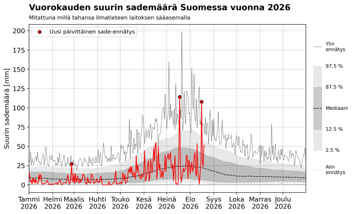
However, the events of August 16, 2026, in Pelmaa, Seinäjoki, blew past these warning thresholds with ease. Within a single hour, a weather station recorded 68.6 millimeters of rain, with the total 24-hour accumulation reaching a staggering 107.7 millimeters. Under current warning protocols, such a deluge would have warranted a red-level alert, the highest possible tier of danger. This was not an isolated incident; on July 18, 2026, the town of Multia also recorded a 24-hour accumulation exceeding 100 millimeters.
For the average citizen, a 100-millimeter rainfall in 24 hours is a once-in-a-lifetime event, if it occurs at all. Meteorologically, it is an anomaly that strains the limits of current drainage and flood management infrastructure.
A Study in Frequency: Local vs. National Perspectives
When assessing how rare these events are, meteorologists approach the data from two distinct angles: the probability of a specific location receiving 100 millimeters of rain, and the probability of that event occurring somewhere within the borders of Finland.
Using data from the Ilmasto-opas (Climate Guide) recurrence tables, we can estimate the likelihood for a single location. For instance, at the Kauhava airport, which shares a similar climatic profile to the affected regions in South Ostrobothnia, the 100-year recurrence level for a 24-hour rainfall is 84 millimeters. The 500-year recurrence level is 114 millimeters. Consequently, the recent downpours in Seinäjoki likely fall between a 100-year and a 500-year event.
However, looking at the entire country changes the picture significantly. The FMI has spent recent years digitizing over a century of historical weather observations. When we aggregate this data, a clear, if concerning, pattern emerges. While a 100-millimeter rainfall is rare for one town, it is far from rare for the country as a whole. Since 1910, there have been 23 recorded instances of at least 100 millimeters of rain falling in 24 hours somewhere in Finland. Statistically, this suggests that the nation experiences such an extreme event approximately once every five years.
Chronology of the Deluge
The summer of 2026 has been particularly notable. We have seen two such events in a single season—a rarity that has only been documented four times since 1900 (in 2004, 2011, 2018, and 2026).
Historically, these events are tightly clustered in the peak of summer, specifically between late June and mid-August. The all-time national record remains the 198.4 millimeters recorded in Lahnus, Espoo, on July 21, 1944. The event in Seinäjoki on August 16, 2026, stands out not just for its intensity, but for its timing, marking the latest date in the calendar year that a 100-millimeter, 24-hour rainfall has ever been recorded in Finland.
Analyzing the Data: Is the Climate Changing?
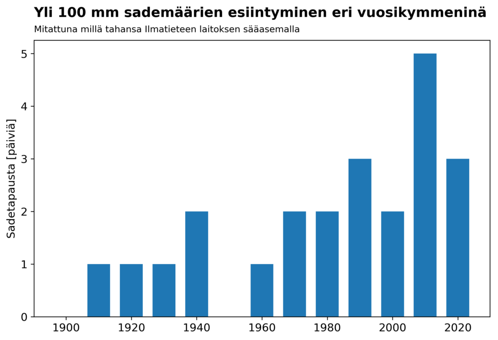
When we plot the occurrence of these events over the past century, a visual trend emerges. In the current decade (2020–2026), there have already been three such events. The previous decade (2010–2019) saw five. Over the last 17 years, we have seen eight instances of 100-millimeter rainfall, which averages out to roughly every other year.
While these numbers show a clear increase, scientists must remain cautious. The FMI’s station network has evolved over the last century; the number of stations, their geographic distribution, and the technology used to measure precipitation have all shifted. Furthermore, the ongoing project to digitize older, paper-based records means that the historical dataset is still being refined. It is possible that some of the "trend" observed in the data is a result of better, more widespread observation rather than just meteorological change.
However, the data is consistent with the warming of the atmosphere. A warmer atmosphere holds more water vapor—a fundamental law of physics known as the Clausius-Clapeyron relation. For every degree of warming, the atmosphere can hold approximately 7% more moisture, which provides the "fuel" for more intense, higher-volume rainfall events.
Official Responses and Future Projections
The implications for urban planning are profound. The current drainage systems in many Finnish municipalities were designed based on historical precipitation norms that are no longer accurate predictors of the future.
Recent research supported by the FMI suggests that the frequency of extreme downpours—defined as more than 20 millimeters per hour—is projected to roughly double by the end of the century under the RCP4.5 emissions scenario. If global temperatures continue to rise at a more aggressive rate, the increase in these intense rain events could be even more significant.
Authorities are now facing a complex challenge: how to retrofit infrastructure that was built for a different climate. This includes expanding storm-water capacity, designing more permeable urban surfaces, and re-evaluating building codes for critical infrastructure like bridges and dams.
The Broader Implications
The shift toward more extreme rainfall is not just a statistical headache for meteorologists; it is a tangible risk to property and safety. The damage caused by the summer 2026 floods serves as a wake-up call. When a "100-year storm" begins to occur every few years on a national scale, the definition of "normal" must change.
We are moving into an era where weather volatility is the default. While we cannot prevent these massive convective storms from forming, we can better prepare for them. The data collected in 2026 is invaluable, not just as a record of a wet summer, but as a roadmap for how we must adapt.
The message from the weather data is clear: the atmosphere is changing, and with it, the hydrological cycle of the North. Whether it is the flash flooding in a suburban street or the overflowing of a river in the countryside, the "extreme" is becoming the new standard. For policymakers, engineers, and the public, the task is no longer to wait for the rain to stop, but to build a society that can withstand the deluge.
Mika Rantanen is a meteorologist focusing on severe weather and climate change. This analysis relies on historical observation data provided by the Finnish Meteorological Institute and current climate modeling projections.