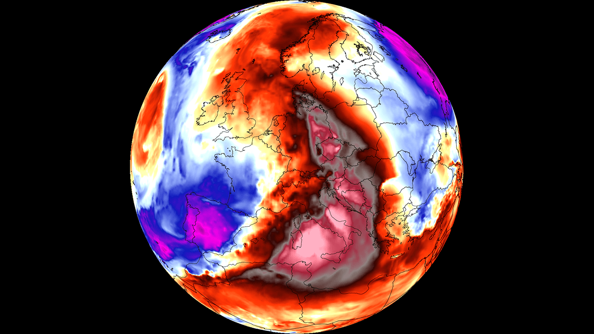
As the final week of August 2026 unfolds, Europe finds itself gripped by its sixth major heatwave of the season. A persistent and powerful "Heat Dome"—a high-pressure blocking system—has anchored itself over the Central Mediterranean and Southern Europe, setting the stage for a period of extreme, record-challenging temperatures. Meteorologists warn that the atmospheric configuration is not merely a temporary spike in mercury, but a stable, self-reinforcing engine of heat that threatens to strain public health infrastructure, energy grids, and ecosystems across the continent.
The Atmospheric Engine: Anatomy of a Heat Dome
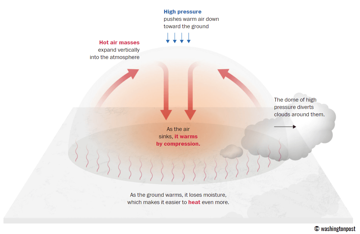
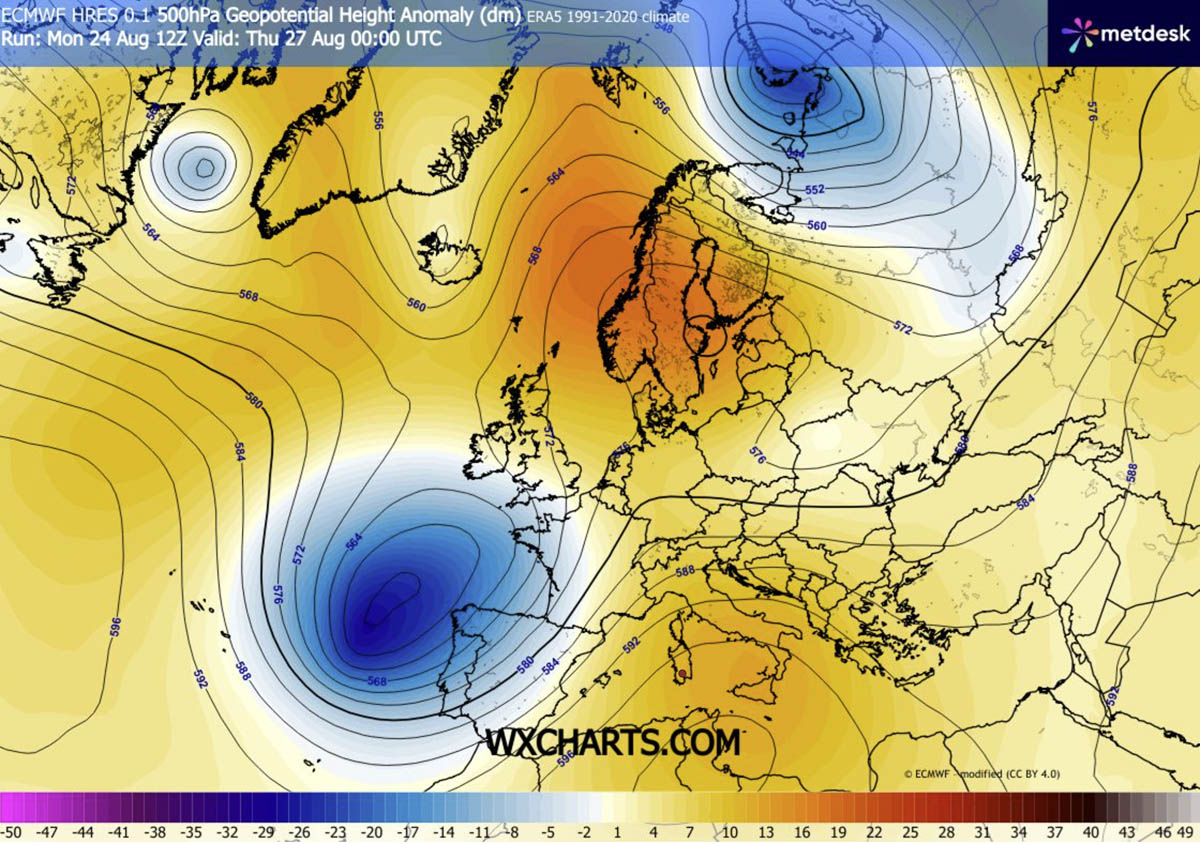
At the heart of this weather event lies a stagnant, high-pressure ridge, a phenomenon meteorologists describe as an "omega block" or a stubborn blocking high. Functioning much like a lid on a boiling pot, this system traps warm air beneath it, preventing the normal circulation that would otherwise disperse thermal energy.
The dynamics of this heat dome are driven by adiabatic compression. As air is forced downward from the upper troposphere toward the surface, it undergoes compression, which in turn causes the air mass to heat up rapidly. This sinking motion suppresses cloud formation, allowing uninterrupted solar radiation to bake the surface. With dry continental winds exacerbating soil moisture loss, the ground itself ceases to act as a cooling agent, further accelerating the rise in surface temperatures.
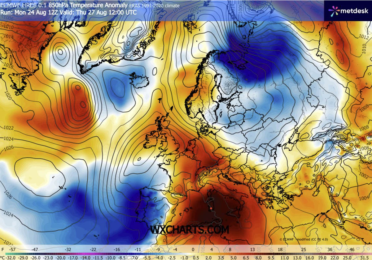
In regions across Italy, the Balkans, and parts of Central Europe, this process is expected to push peak afternoon temperatures into the 38°C to 43°C range. These are not merely seasonal highs; they represent significant anomalies of 12°C to 16°C above the long-term averages for late August.
Chronology of the Thermal Surge
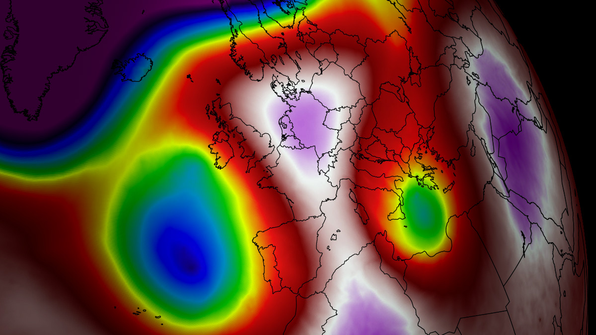
The current heatwave is a result of a complex interplay between an advancing North African air mass and a deep upper-level wave currently situated over the Bay of Biscay.
Mid-Week Peak (Wednesday–Thursday)
As the ridge expands from the Mediterranean northward, the primary impact zone centers on Italy and the central Balkans. By Thursday, the "warm plume" associated with the heat dome will push across the Alps, affecting Germany and the Alpine regions with temperatures climbing into the mid-30s. Simultaneously, a sharp pressure gradient between the heat dome and the low-pressure system in the west will set the stage for severe weather in France.
The Weekend Transition (Friday–Sunday)
Friday is projected to be the most intense day for Italy and the central Balkans, with peak temperatures likely to hit the 42°C–43°C mark. As the heat dome begins to elongate, it will shift its focus eastward. By the weekend, the most severe conditions will migrate from Central Europe toward Poland and western Ukraine. Conversely, Western Europe, including the UK and Benelux, will begin to see a reprieve as Atlantic maritime air pushes into the region, displacing the stagnant heat.
Supporting Data: Understanding the "Tropical Night"
One of the most alarming aspects of this heat dome is the lack of nocturnal cooling. In major urban corridors, temperatures are struggling to dip below 22°C to 26°C. These "tropical nights" are a critical metric in public health, as they deny the human body the vital recovery window required after a day of extreme heat exposure.
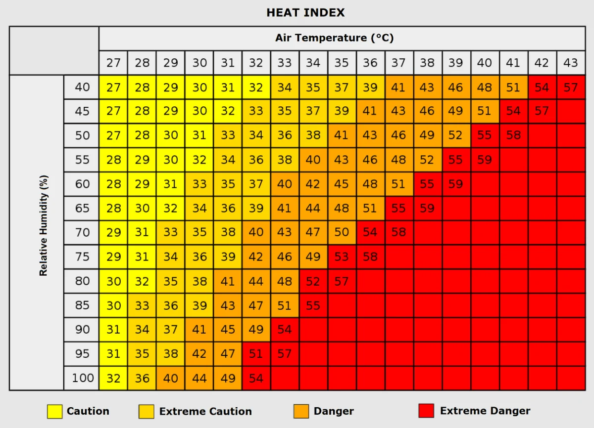
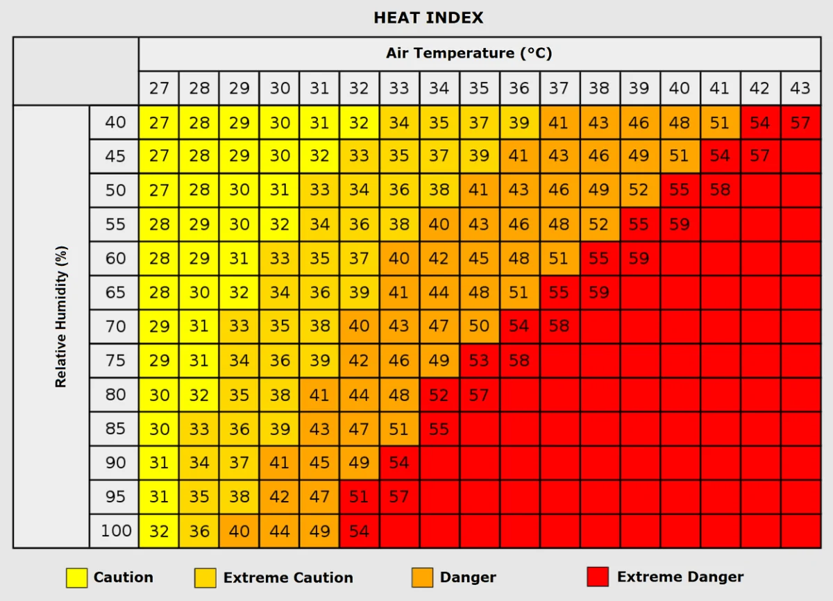
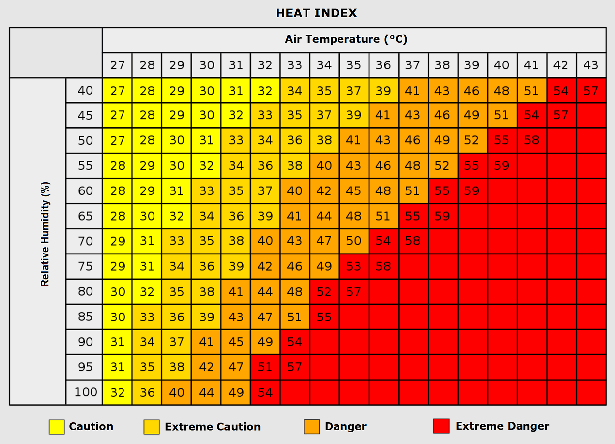
When examining the "Heat Index"—the perceived temperature based on a combination of heat and relative humidity—the danger becomes even more apparent. While 35°C is dangerous on its own, when humidity levels climb above 80%, the body’s primary cooling mechanism, perspiration, becomes ineffective. Under these conditions, the "feels-like" temperature can soar toward 50°C, a threshold that rapidly accelerates the onset of heat-related illnesses, including heat exhaustion and life-threatening heat stroke.
Implications for Health and Infrastructure
The humanitarian implications of this event are broad. Vulnerable demographics, including the elderly, young children, and those with pre-existing respiratory or cardiovascular conditions, face the highest risk. Furthermore, those living in urban "heat islands"—areas characterized by high concentrations of concrete and asphalt—are disproportionately affected, as these materials absorb solar radiation during the day and re-radiate it throughout the night.
Energy Grid Strain
As millions of residents turn to air conditioning to cope with the relentless heat, energy grids across Southern and Central Europe face unprecedented demand. This spike not only threatens localized brownouts but also creates a feedback loop: increased energy consumption often leads to higher carbon emissions, which in the long-term context of a warming climate, contributes to the very conditions that spawn these heat domes.
Wildfire Risk
The combination of sustained heat and dry soil moisture creates a tinderbox environment. Across the valleys of Southern Europe and the Balkans, the risk of explosive wildfire growth is at a seasonal high. The lack of soil moisture limits the natural transpiration of vegetation, leaving forests and grasslands exceptionally dry and vulnerable to ignition from even minor sparks.
The "Severe Weather" Paradox: A Violent Conclusion
While the heat dome brings stifling, dry air to the Mediterranean, the periphery of this system is creating a hazardous juxtaposition. The interaction between the intense heat dome and a deep low-pressure wave over the Bay of Biscay is generating significant vertical wind shear over France.
Meteorological models indicate that atmospheric instability (CAPE) in these regions could reach between 3,000 and 5,000 J/kg. This creates a volatile environment where the arrival of cooler, moisture-laden air could trigger explosive thunderstorm development. These are not ordinary storms; they have the potential to produce giant hail, intense lightning, severe wind gusts, and, in extreme instances, tornadic activity. This "severe weather outbreak" serves as a violent reminder that the destabilization of the upper atmosphere during heatwaves can lead to rapid, dangerous shifts in weather conditions.
Looking Ahead: A New Normal?
As we move into early September, the long-term trends suggest that the pattern will remain dynamic. While this specific heat dome is expected to subside by the start of next week, the persistence of these events—this is the sixth of the 2026 season—raises difficult questions for policymakers and urban planners.
The reliance on short-term disaster management is increasingly being viewed as insufficient. Experts are calling for more robust infrastructure, such as the implementation of "cool roofs," the expansion of urban green spaces, and the modernization of electrical grids to handle the increasing frequency of extreme temperature events.
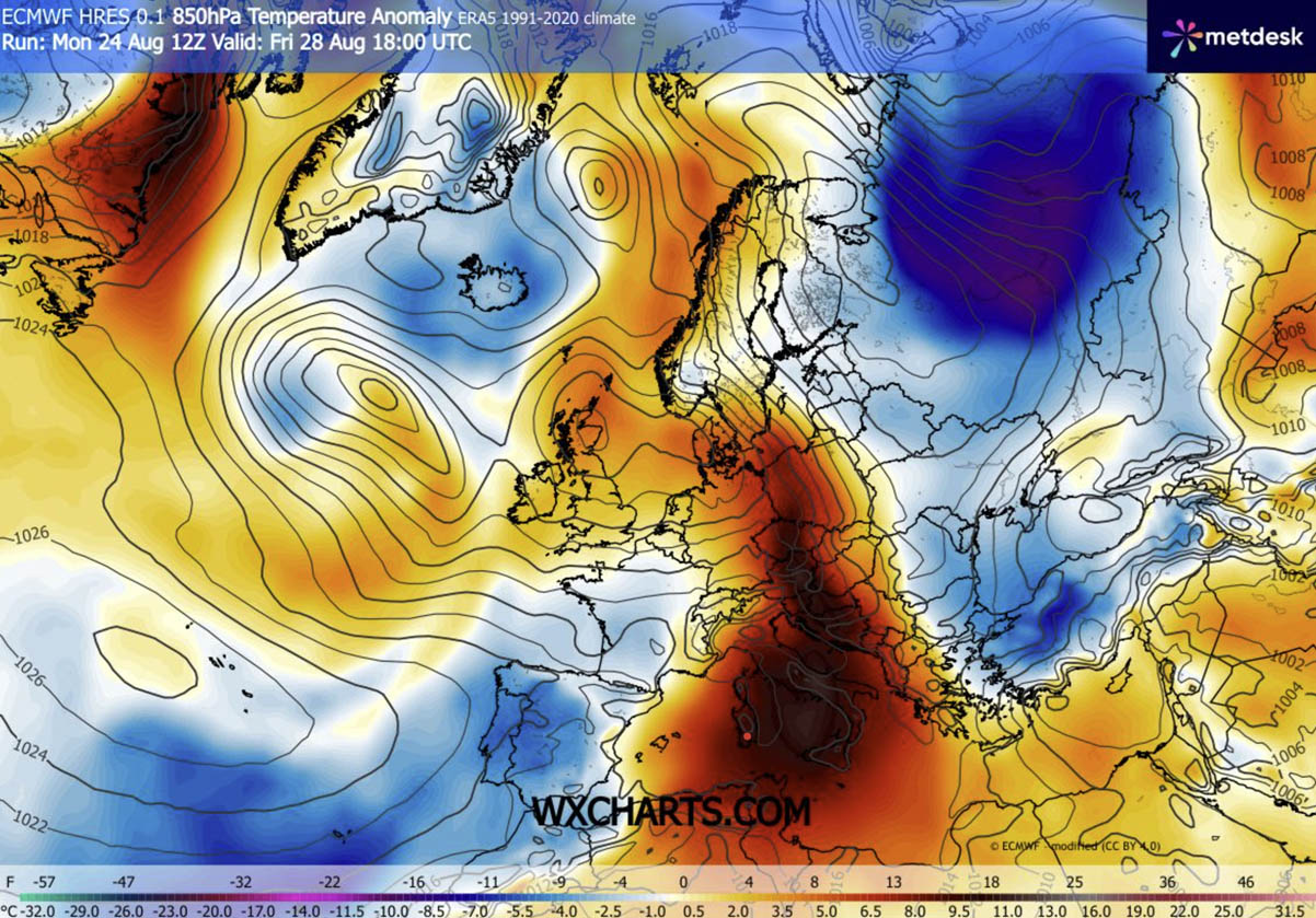
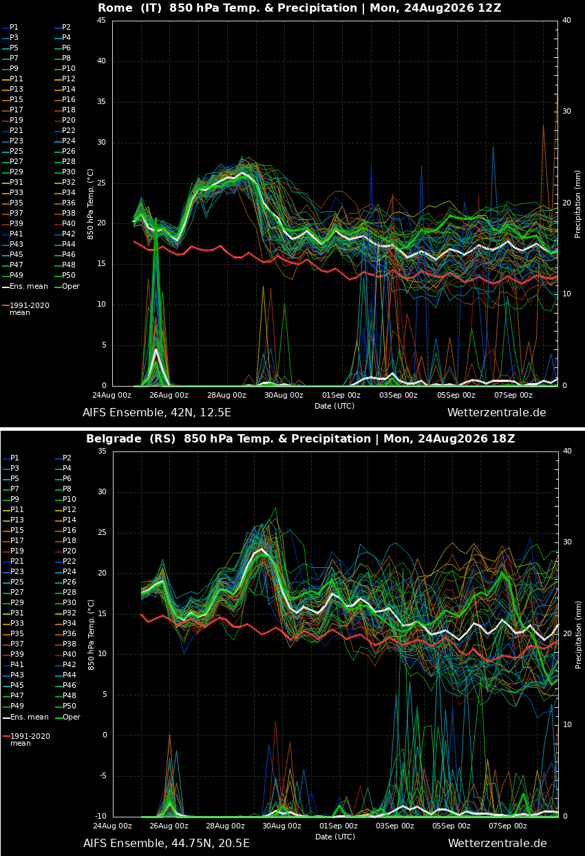
The data provided by meteorological institutions—including the meteograms for Rome and Belgrade—confirm that this is not an isolated incident but part of a broader, more intense thermal trend across the European continent. As the heat dome shifts eastward, authorities in Poland, Ukraine, and the Balkans are advised to prepare for record-breaking heat, urging citizens to monitor local weather alerts, stay hydrated, and limit outdoor exposure during the peak hours of 11:00 AM to 6:00 PM.
In conclusion, the late-summer heatwave of 2026 serves as a stark manifestation of atmospheric instability. Whether through the direct threat of heat stroke or the indirect risks of severe storm outbreaks, the current weather pattern demands a high level of vigilance from both the public and emergency response agencies across the affected regions. As we monitor the weakening of the ridge toward the weekend, the focus remains on navigating the final, most intense days of this thermal siege.