July 20, 2026 — For millions of Americans, summer is synonymous with the “National Park pilgrimage.” From the jagged, snow-dusted peaks of the North Cascades to the echoing, subterranean depths of Colorado’s slot canyons, these protected landscapes represent the pinnacle of the American outdoor experience. However, as of mid-July 2026, that experience has been fundamentally altered. A volatile combination of record-breaking heat, intensifying wildfire activity, and violent, erratic thunderstorms has rendered vast swaths of the National Park System inaccessible, turning anticipated vacations into logistical nightmares.
The Reality of a Fragile Wilderness
The Great Outdoors has always demanded a level of respect for the elements, but the current state of our public lands suggests a shift in the baseline of "normal" weather. We are no longer just dealing with the occasional summer storm; we are witnessing a systemic struggle against environmental instability.
As of late July 2026, the National Park Service (NPS) has issued a flurry of emergency alerts. These are not merely suggestions to "tread lightly"—these are mandatory closures, evacuation orders, and, in some cases, life-saving rescues necessitated by flash floods and rapidly encroaching infernos. For travelers planning their summer excursions, the message from park authorities is singular and urgent: Verify before you travel.
Chronology of a Crisis: July 2026
The current wave of disruptions began in earnest early this month, following a sustained period of high-pressure systems that baked the American West.
- July 8: North Cascades National Park reported the initial growth of the "Luna" fire, which began as a small, manageable ignition point but quickly accelerated due to parched forest floor conditions.
- July 16: A massive, localized thunderstorm cell stalled over western Colorado. The resulting deluge turned the arid terrain around the Black Canyon of the Gunnison into a chute for mud and debris, trapping visitors in the East Portal area.
- July 17: NPS officials confirmed the expansion of the Luna fire to 22 acres, forcing the closure of high-altitude cross-country zones and critical drainage areas.
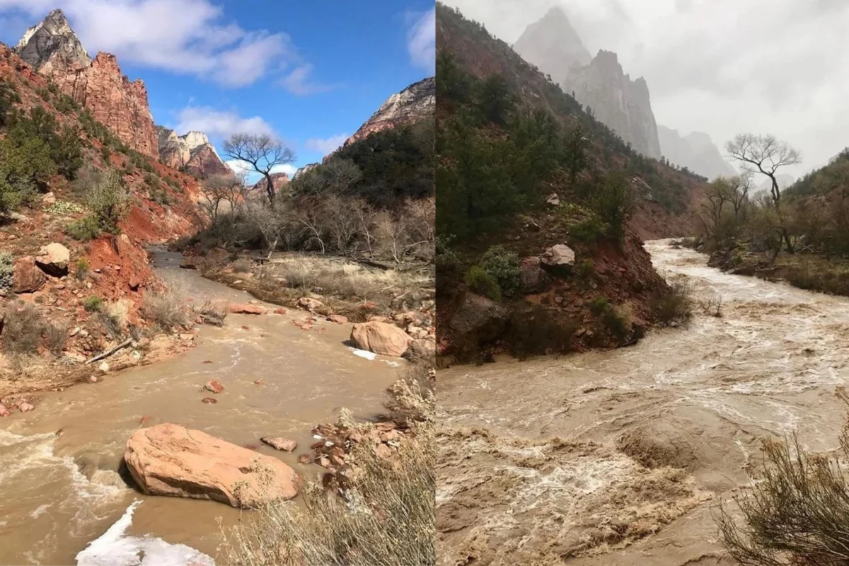
- July 19: Zion National Park’s monitoring equipment detected a spike in the flow rate of the Virgin River, crossing the threshold of 150 cubic feet per second (CFS). The park immediately triggered its emergency closure protocol for all slot canyons.
- July 20: Air quality indices across the Pacific Northwest reached “Hazardous” levels, prompting warnings for park staff and nearby communities, effectively limiting all non-essential operations in several wilderness areas.
Deep Dive: Critical Hotspots
Black Canyon of the Gunnison National Park
The damage at Black Canyon is a stark reminder of how quickly terrain can become lethal. On July 16, following the heavy rainfall, East Portal Road—the primary artery for campers and recreationists—was buried under three major mudslides.

The incident was harrowing. Twenty-one visitors, caught at the bottom of the canyon road, were effectively cut off from civilization. The subsequent rescue operation, conducted by NPS search-and-rescue teams, was successful, resulting in zero injuries. However, the infrastructure damage is significant. The road, the adjacent campground, and the popular picnic areas remain shuttered as geological engineers assess the slope stability. The park, which suffered massive wildfire scarring in 2025, is currently proving that burned landscapes are significantly more prone to debris flows during rain events.
Zion National Park: The Peril of the Narrows
Zion has long been the gold standard for desert hiking, but it is also the most dangerous. The Narrows, a world-famous slot canyon, is essentially a geological trap during monsoon season. Because these canyons are carved from impermeable sandstone, water from storms occurring miles away can travel through the canyons with zero warning, rising several feet in seconds.
The park’s decision to close these areas is based on strict, data-driven thresholds. When the Virgin River hits 150 CFS or the National Weather Service issues a Flash Flood Warning, the park shuts down access. Currently, the NWS maintains a "Probable" status for flash flooding, keeping the most popular trails off-limits. The implementation of a mandatory lottery system for Narrows permits has made these closures even more impactful for visitors who have spent months planning their trips, only to be turned away at the trailhead.
North Cascades National Park: A Legacy of Instability
North Cascades is currently fighting a two-front war: the remnants of 2025’s catastrophic flooding and the birth of 2026’s wildfires. The Stehekin Valley, a jewel of the park, remains in a state of suspended animation due to a destroyed wastewater system that has yet to be fully restored.
The current fires, specifically the Luna fire, are burning in rugged, inaccessible terrain, making traditional fire-suppression tactics difficult. The closures of the Chilliwack and Little Beaver areas serve as a grim reminder that once a park’s infrastructure is damaged by fire, it can take years—or even decades—for the landscape to stabilize enough for safe human transit.

Official Responses and Data Analysis
The National Park Service has been forced to shift its management philosophy from "visitor-centric" to "safety-first" with increasing frequency. In official statements, the agency emphasizes that the current conditions are not isolated incidents but a reflection of a changing climate.
"We prioritize the safety of our visitors and our staff above all else," said a spokesperson for the NPS. "While we understand the frustration of cancelled vacations, the unpredictability of these events leaves us with no choice but to restrict access until we can guarantee that the environment is safe for human entry."
Meteorological data from the National Weather Service supports the NPS’s caution. Atmospheric moisture levels in the West have been anomalous, leading to "pulse" storms that dump vast amounts of rain on drought-stricken, fire-hardened ground—a recipe for maximum erosion and debris flow.
The Broader Implications for Outdoor Recreation
This summer’s closures highlight a growing divide between our expectations of nature and the reality of an increasingly volatile climate.
The Financial and Emotional Cost
For the individual traveler, a closure means lost deposits, wasted vacation time, and the stress of rebooking. For local gateway communities—the small towns that rely on the influx of park visitors for their annual revenue—these closures are an economic disaster. Hotels, guide services, and gear shops often see their busiest months evaporate overnight.

The New Rules of Engagement
If there is a silver lining, it is that the public is becoming more tech-savvy regarding their safety. Tools like AirNow.gov are becoming as essential as a topographical map. The era of the "spontaneous road trip" is being replaced by the "informed excursion."
Experts recommend a three-tier approach for anyone planning a trip to a national park this summer:
- Check the Park Website (The 24-Hour Rule): Do not rely on information that is more than 24 hours old. Park conditions can change from "Open" to "Emergency Closure" in a matter of minutes.
- Monitor Regional Weather, Not Just Park Weather: A storm 20 miles away can create a flash flood in a canyon. Look at the entire regional forecast.
- Have a "Plan B": Always identify an alternative destination that is geographically distinct from your primary goal. If the mountains are burning, consider a lower-elevation coastal or prairie site.
Conclusion: A Changing Landscape
The beauty of the National Park System is that it is a living, breathing entity. It changes, it burns, it floods, and it regenerates. However, the speed at which these changes are currently occurring is unprecedented. As we navigate the remainder of the 2026 season, the lesson for the public is clear: we must treat our public lands with more humility.
We are not just visitors; we are guests in a landscape that is under significant stress. By staying informed, respecting closures, and prioritizing safety over the "perfect photo," we can help ensure that these magnificent spaces endure for generations to come, even as the climate around them continues to shift. Before you pack your bags and head for the trailhead, take a moment to check the latest bulletins. The wild is open, but it is also unforgiving. Proceed with caution.