Valid: August 27, 2026, 06 UTC – August 29, 2026, 06 UTC
A significant and potentially life-threatening meteorological event is set to unfold across the European continent starting this Thursday. According to the latest data issued by Severe Weather Europe and meteorologist Marko Korošec, a powerful two-day severe weather outbreak is expected to track across Western and Central Europe. From the plains of Eastern France to the industrial heartlands of Poland, residents are being warned of an atmospheric environment capable of producing giant hail, destructive wind gusts, flash flooding, and tornadoes.
1. Executive Summary: A Volatile Atmospheric Convergence
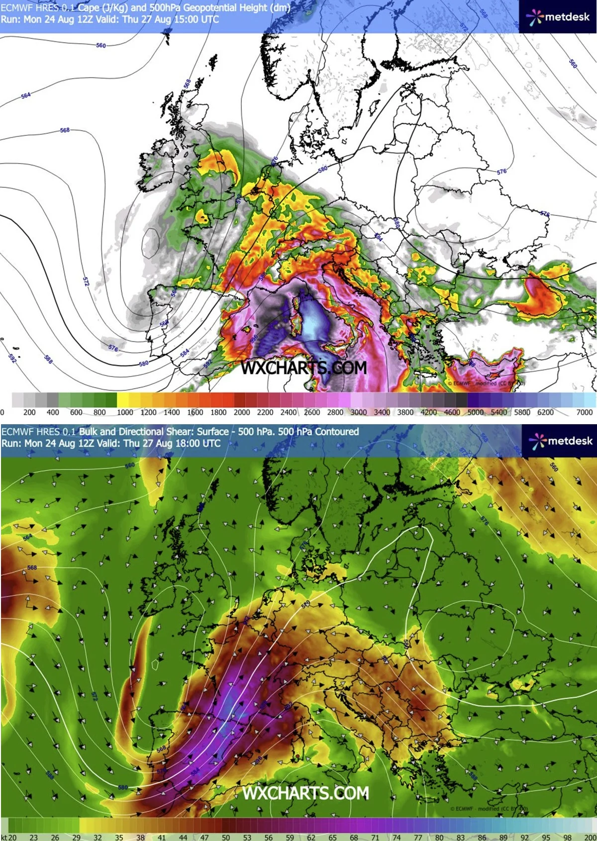
The upcoming weather event is driven by a complex interaction between a deep, encroaching upper-level trough from the Atlantic and a persistent, robust blocking high-pressure system anchored over the Mediterranean. This "tug-of-war" between air masses has created a high-stakes environment characterized by moderate-to-extreme instability and intense wind shear.
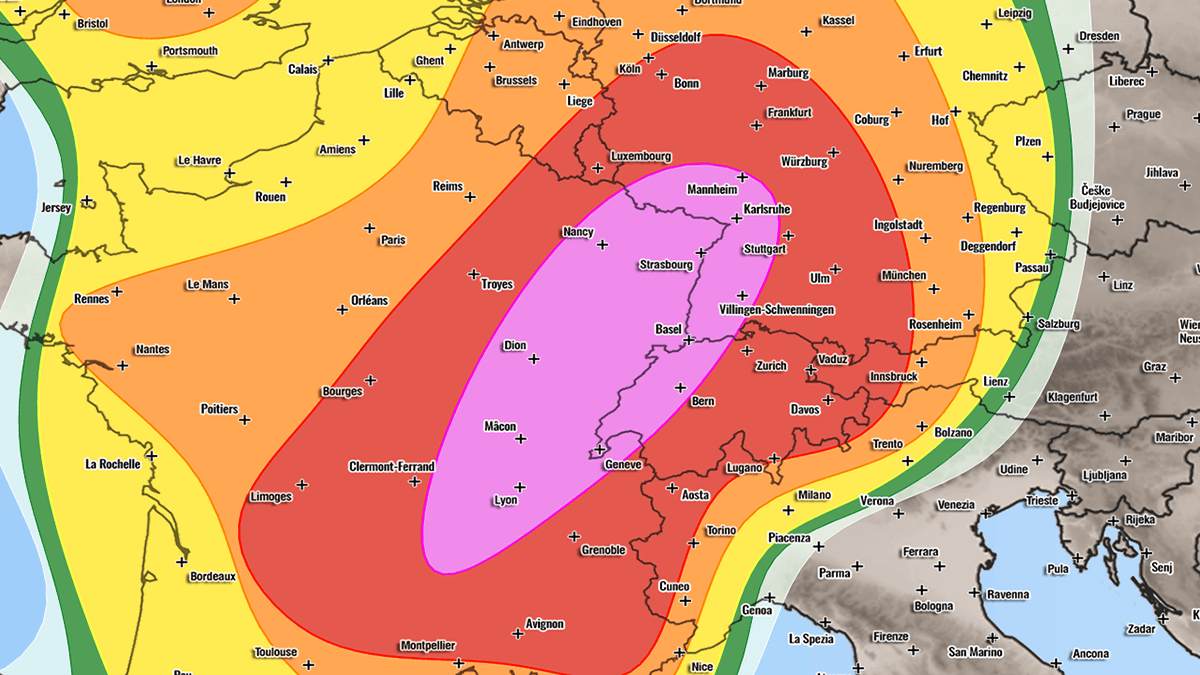
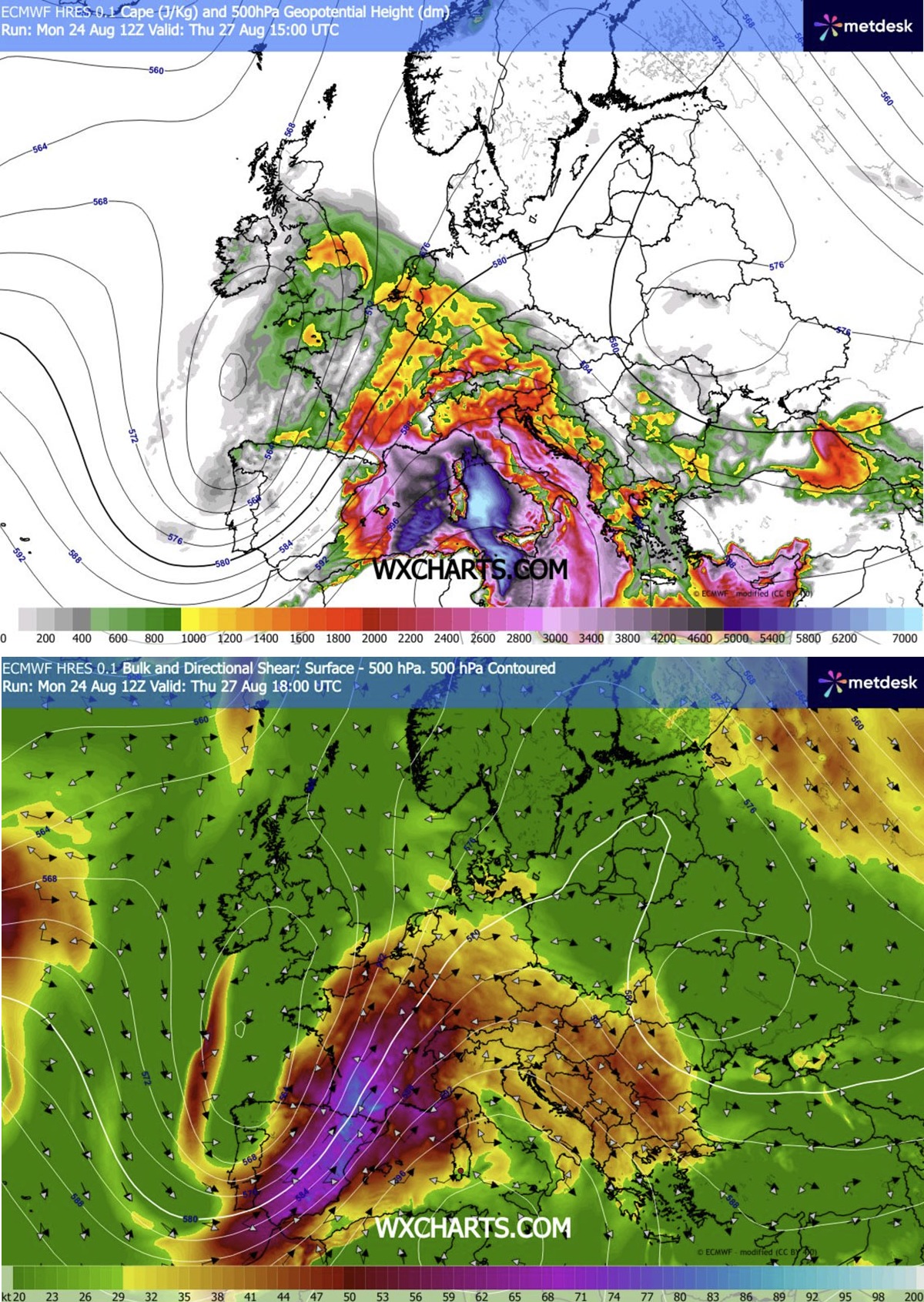
On Thursday, the primary focus will be Eastern France, Switzerland, and Southwestern Germany. As the system matures, the atmospheric focus shifts eastward on Friday, impacting the Alpine regions, the Czech Republic, and Southwestern Poland. With MLCAPE (Mixed-Layer Convective Available Potential Energy) values expected to reach between 2,000 and 4,000+ J/kg in some sectors, the energy available for storm development is substantial. Authorities are urging the public to prepare for a dangerous 48-hour window of extreme convective activity.
2. Chronological Breakdown: The Evolution of the Storm
The development of this outbreak is segmented into two distinct phases, dictated by the movement of a cold front and the propagation of the jet stream.
Phase I: Thursday, August 27 – The French-German Corridor
The morning hours of Thursday will see the atmosphere priming itself. As solar heating progresses, the "left-exit region" of a powerful jet stream will provide the necessary lift to trigger explosive convective development.
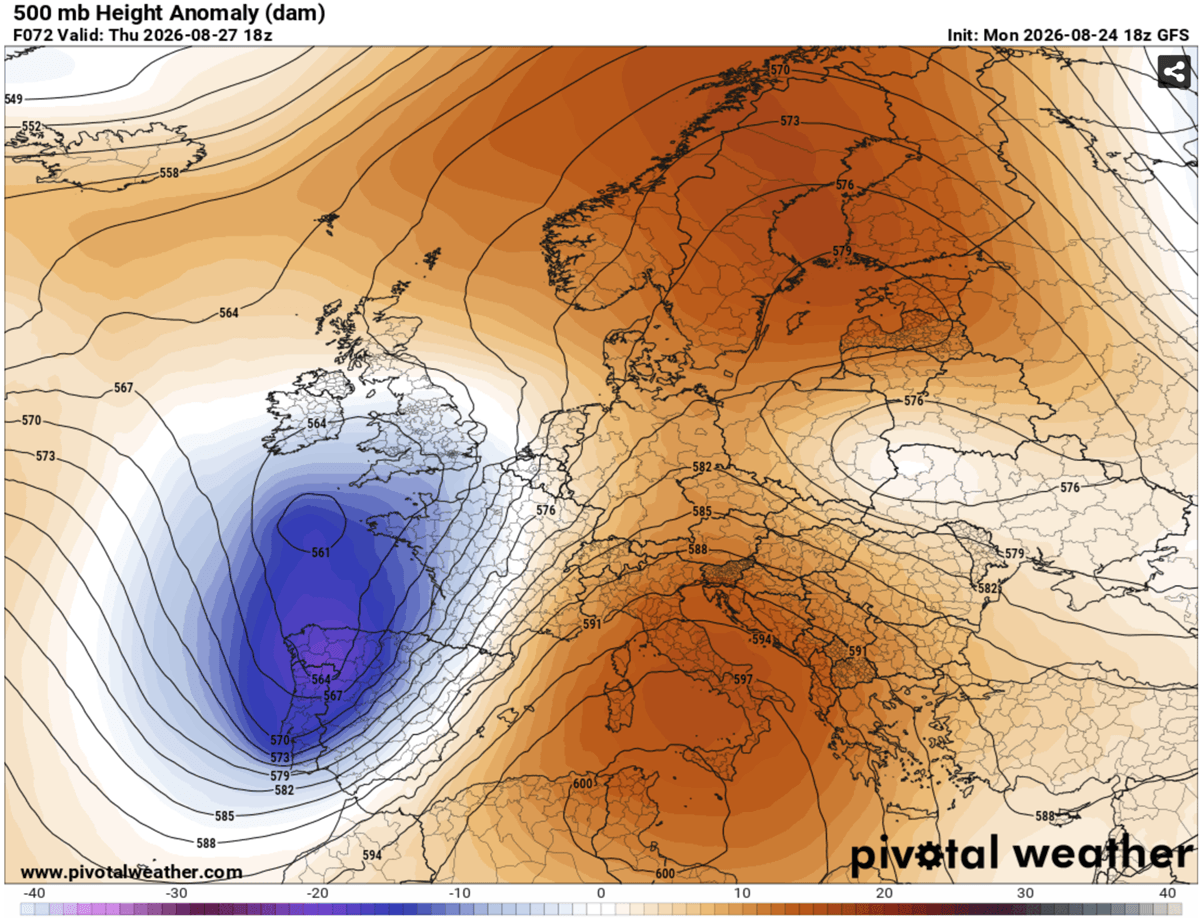
- Midday to Afternoon: Initiation is expected over the Massif Central in France. Moist, southerly winds originating from the heat-stricken Mediterranean will transport high dewpoints into the Rhone Valley, fueling the creation of individual, isolated supercells.
- Evening: These supercells, characterized by their high rotation potential, will push rapidly east-northeast. As they encounter the terrain of Western Switzerland and Southwestern Germany, they are expected to cluster into larger, more formidable convective systems.
- Night: The risk remains high well into the night. As the storms merge, they will form massive clusters capable of sustaining severe wind-driven hail and torrential downpours as they traverse the border regions into Central Germany.
Phase II: Friday, August 28 – The Alpine and Central European Shift
By Friday morning, the focus of the atmospheric instability will have shifted further east, tracking along the Alps and into the heart of Central Europe.
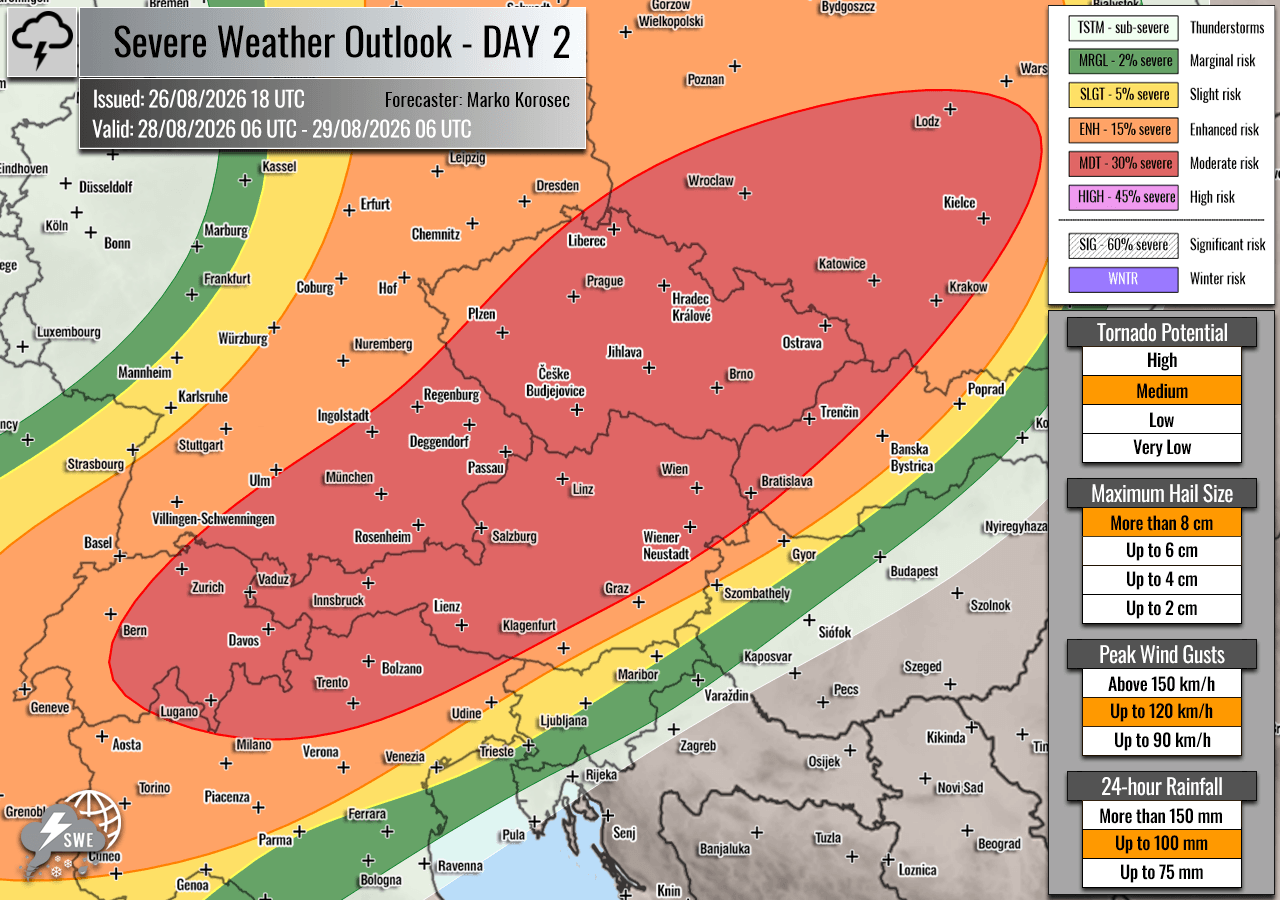
- Morning and Early Afternoon: The system will re-intensify over the Alps. The combination of orographic lift (terrain-induced rising air) and the incoming synoptic-scale forcing will lead to a rapid transition from individual storms to a broad, potentially destructive Mesoscale Convective System (MCS).
- Late Afternoon to Night: The primary concern for Friday is the formation of a bowing line segment—a classic signature of wind-driven damage. Models indicate a potential for wind gusts exceeding 120 km/h as this system moves from Southeastern Germany and Northern Austria into the Czech Republic and Southwestern Poland.
3. Supporting Data and Meteorological Mechanics
The severity of this forecast is underpinned by three specific meteorological drivers that, when combined, create a "perfect storm" scenario.
The Mediterranean Influence
The ongoing Mediterranean heatwave is not just a localized issue; it is a critical fuel source. The high sea-surface temperatures and heat-loading on the landmasses have resulted in an air mass of exceptional humidity. When this humid air is pulled northward by the southwesterly flow, it provides the "moisture fuel" required to sustain severe convection.
The Jet Stream and Wind Shear
A strong southwesterly jet stream is cutting across the western Mediterranean, providing what meteorologists call "deep-layer shear." In simple terms, this means that wind speeds increase significantly with altitude, which tilts the thunderstorms, allowing them to remain organized for much longer periods. This organization is what allows storms to produce giant hail (6–10 cm in diameter) and provides the rotational energy required for tornado development.
Storm-Relative Helicity
The "tornadic potential" is particularly concerning in the Rhone Valley. Here, the low-level wind shear and the specific orientation of the inflow are creating high Storm-Relative Helicity (SRH). This is the "spin" in the lower atmosphere that is essential for the development of mesocyclones—the rotating updrafts within a storm that produce tornadoes.
4. Geographic Risk Assessment
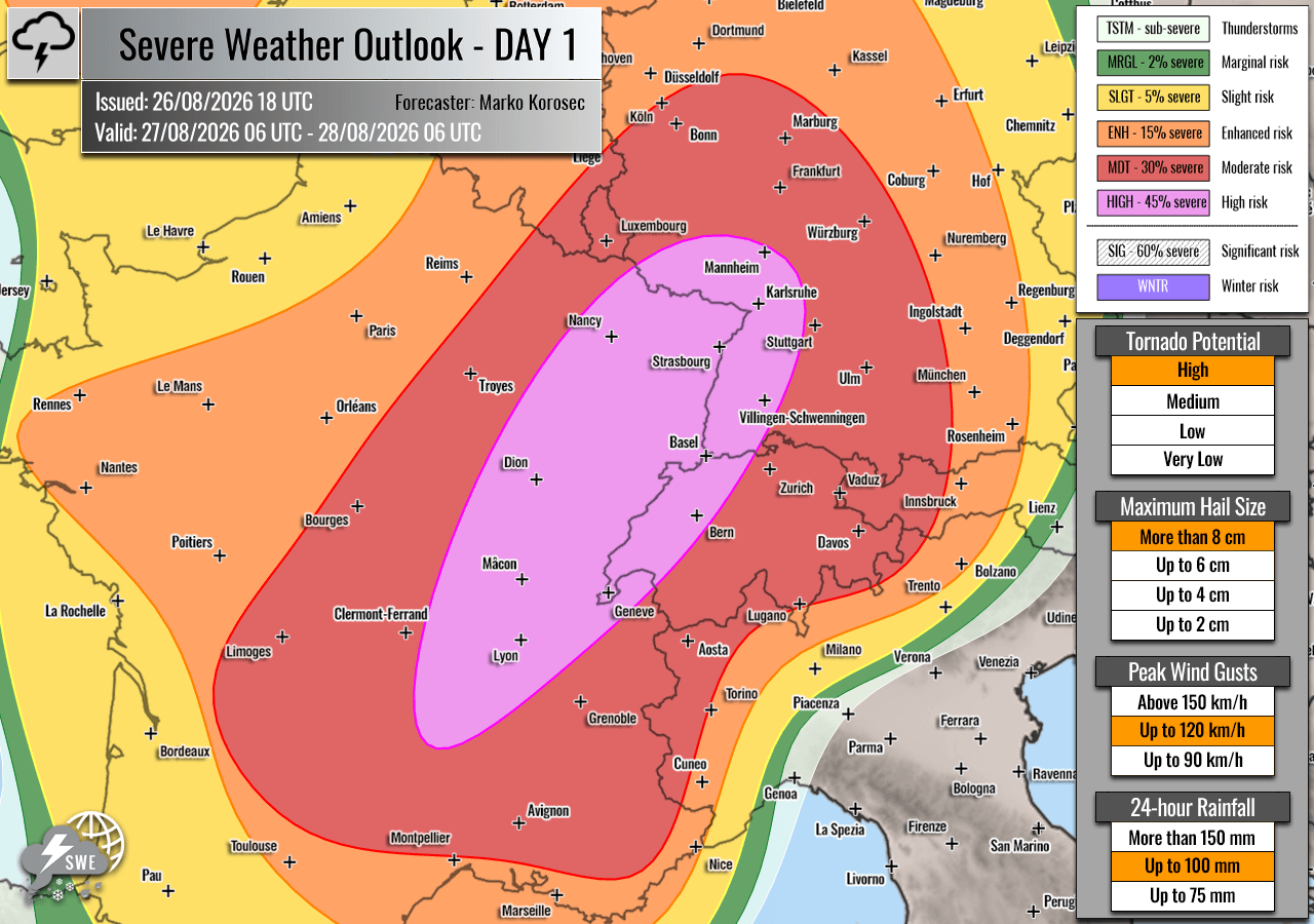
To help the public understand the level of danger, risk zones have been categorized by Severe Weather Europe:
- HIGH Risk (Purple Zones): These represent the areas of greatest concern where the combination of ingredients is optimal for violent weather. Residents in these zones should expect the highest density of large hail, damaging winds, and a heightened risk of tornadoes.
- MDT/ENH Risk (Red and Orange Zones): These regions surround the high-risk zones. While the coverage of the most severe storms might be lower than in the "high-risk" core, the potential for individual storms to become severe remains very high.
- Secondary Threats: While the primary focus is on the mainland, isolated severe storms are also possible across Southern England during peak heating, as the wave axis crosses the English Channel.
5. Implications for Infrastructure and Public Safety
The implications of this weather event are far-reaching. Emergency management agencies in France, Switzerland, Germany, Austria, the Czech Republic, and Poland are already coordinating to monitor the situation.
Impact on Transportation and Utilities
With wind speeds potentially exceeding 120 km/h, the impact on regional power grids could be significant. Residents should anticipate localized power outages due to downed trees and damaged distribution lines. Furthermore, air travel and rail transport through the Alpine corridors are likely to face severe disruptions as the convective clusters pass through.
Flood Mitigation
Because the soil in many of these regions is already saturated from previous rainfall, the flash flood potential is elevated. "Torrential rainfall" as described in the forecast implies that urban drainage systems may be overwhelmed in minutes. Motorists are strongly advised to avoid driving through standing water, as the force of flash floods can easily sweep vehicles away.
Preparation Checklist
- Secure Property: Ensure all outdoor furniture, equipment, and loose items are secured or brought indoors before Thursday afternoon.
- Stay Informed: Monitor local national meteorological services for specific, time-sensitive warnings. Do not rely on a single source of information.
- Create a Plan: Identify a safe place in your home—ideally an interior room away from windows—in case of a tornado or high-wind warning.
- Avoid Travel: If possible, reschedule any long-distance travel across the Alps and through the German-Polish corridor for the duration of the 48-hour event.
6. Official Outlook and Closing Remarks
The science behind this forecast is robust, supported by high-resolution models such as the WRF (Weather Research and Forecasting) model, which clearly depicts the formation of the convective systems. However, as with all severe weather events, the exact location of the most damaging storms can shift based on minor changes in the atmosphere.
Severe Weather Europe emphasizes that the "uncertainty" lies only in the exact path of the most violent bowing segments of the storm. The ingredients for a major, widespread outbreak are undeniably present. As the atmosphere becomes increasingly unstable over the next 24 hours, citizens are encouraged to take all weather alerts seriously. This is not a typical summer storm; it is a high-impact event that requires vigilance and respect for the volatility of the European climate.
Data and imagery provided for this report by Meteoadriatic, Wxcharts, and PivotalWeather. Please continue to follow local authorities for real-time updates as the system progresses.