Valid Period: September 9, 2026, 06:00 UTC – September 11, 2026, 06:00 UTC
Issued by: Severe Weather Europe | Lead Forecaster: Marko Korosec
A significant, multi-day severe weather event is set to impact large swathes of the Western and Northern Mediterranean, stretching from the Balearic Islands across to the Alpine regions and the Adriatic coast. Forecasters have signaled a high-stakes meteorological environment, warning that a collision between extreme atmospheric instability and a potent, deep-layer jet stream will trigger a widespread outbreak of destructive storms.
Main Facts: A Convergence of Volatile Conditions
The current synoptic situation is driven by a deep, upper-level trough currently advancing across Western Europe. This feature is poised to interact with a collapsing blocking high over Eastern Europe, creating a significant pressure and temperature gradient. This dynamic setup is being further energized by a historical marine heatwave currently affecting the Mediterranean basin.
The combination of unseasonably high sea-surface temperatures and an encroaching cold front has primed the atmosphere for extreme convective activity. Meteorologists are particularly concerned about the following hazards:
- Giant Hail: Potential for stones ranging from 6 to 10 centimeters or larger.
- Severe Winds: Destructive, high-velocity gusts capable of causing widespread structural damage.
- Tornadic Activity: A heightened risk of supercell-induced tornadoes, particularly in areas with significant low-level shear.
- Flash Flooding: Torrential rainfall, with some localized models suggesting accumulations exceeding 200–300 mm over a 36-hour window, posing a severe threat to infrastructure and public safety.
Chronology of the Outbreak
Wednesday, September 9th: The Initial Surge
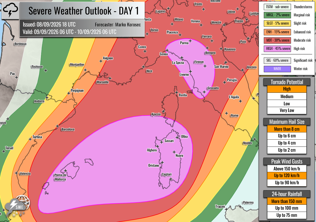
The event begins in earnest on Wednesday morning, focusing initially on the Balearic Islands, southern Corsica, Sardinia, and the coastal regions of Tuscany and Liguria. As the cold front pushes eastward, it taps into extreme instability—MLCAPE (Convective Available Potential Energy) values are projected to reach between 3,000 and 4,000+ J/kg.
Throughout the afternoon, the primary storm mode will shift toward isolated but intense supercells. These storms will move in an east-northeasterly direction, eventually merging into large clusters. The coastal regions of Italy and the Ligurian Bay are at highest risk for tornadic activity due to the interaction between the moist, low-level southeastern flow and the rugged terrain of the Apennines. By Wednesday night, the system will move into the Po Valley, where local convergence will likely fuel further explosive growth, potentially threatening Slovenia and northwestern Croatia by the late evening.
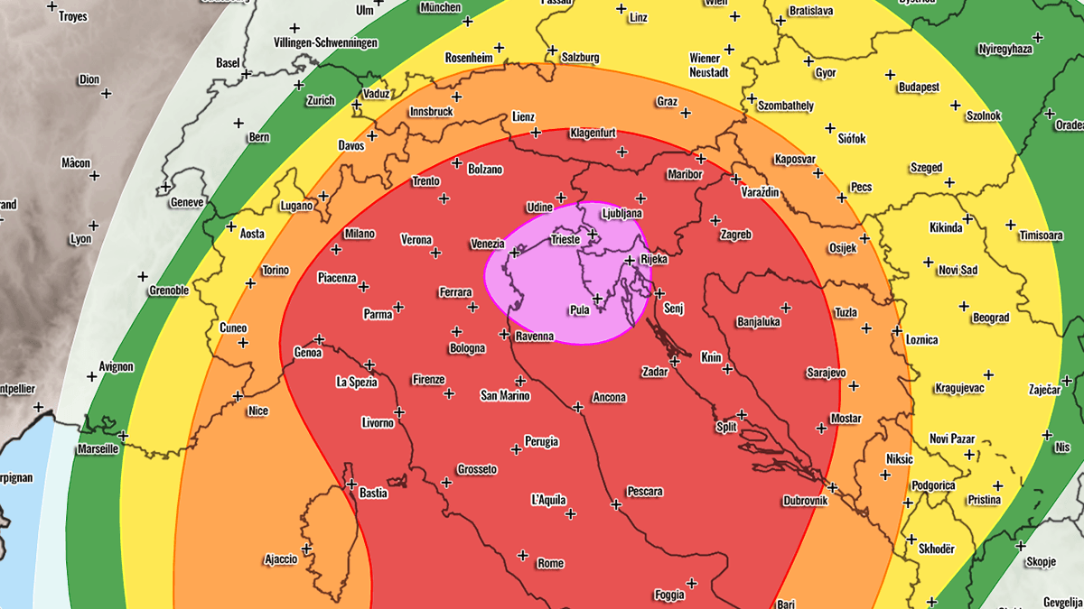
Thursday, September 10th: Intensification and Expansion
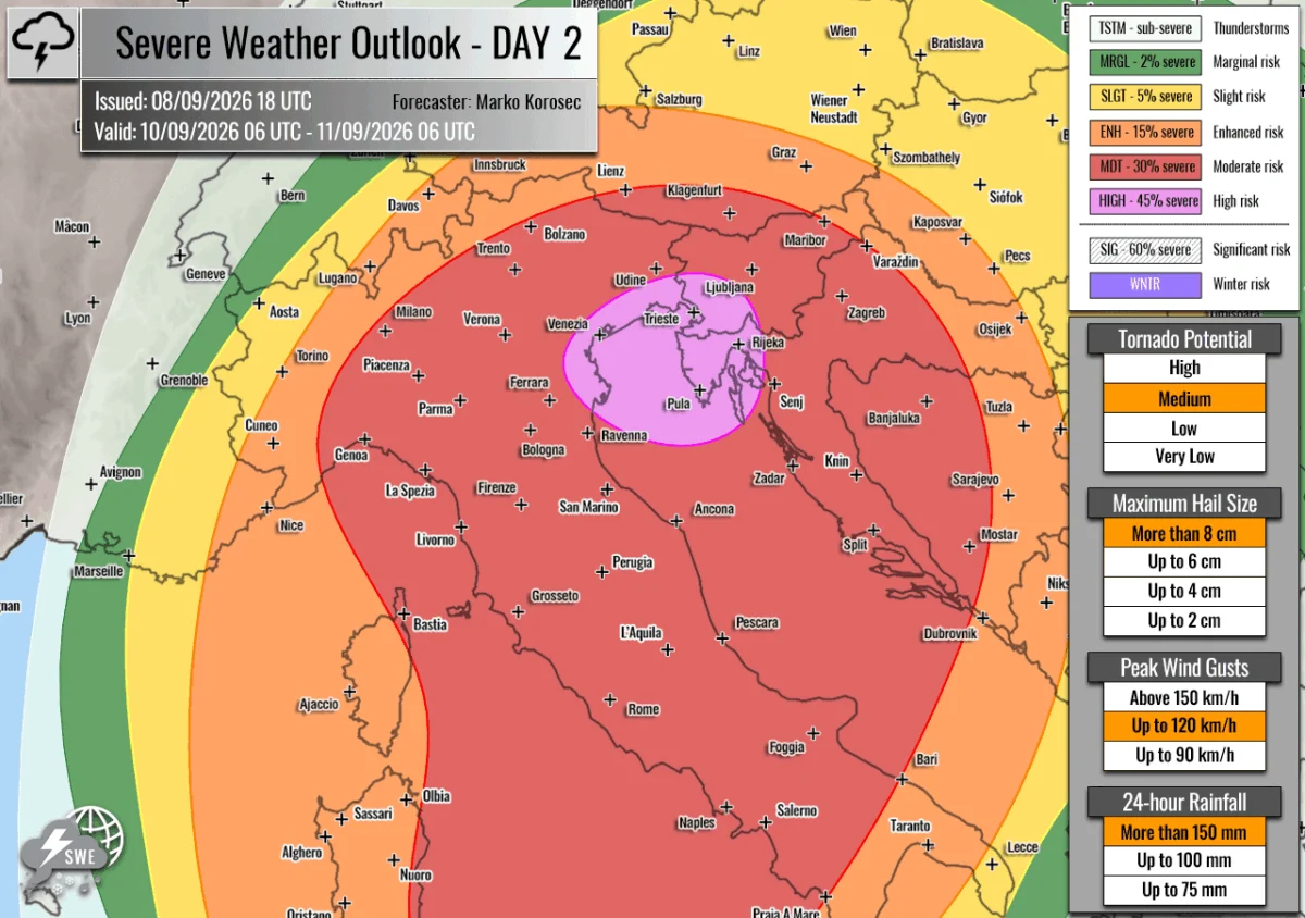
On Thursday, the focus shifts toward the northern Adriatic, northeastern Italy, and the northwestern Balkans. The "High Risk" designation covers these regions, as the cold front continues its slow, destructive progress.
Forecasters warn that while discrete supercells will remain a threat, the primary concern shifts toward "training cells"—consecutive rounds of thunderstorms moving over the same geographic areas. This phenomenon is likely to trigger catastrophic flash flooding, especially in regions that have been suffering from prolonged drought, as the dry, hard-packed soil will be unable to absorb such rapid influxes of water. This pattern is expected to persist through Friday midday, with the most severe activity clustering into large convective systems as they traverse the Adriatic.
Supporting Meteorological Data
The severity of this forecast is underpinned by advanced high-resolution modeling. The primary drivers are twofold:
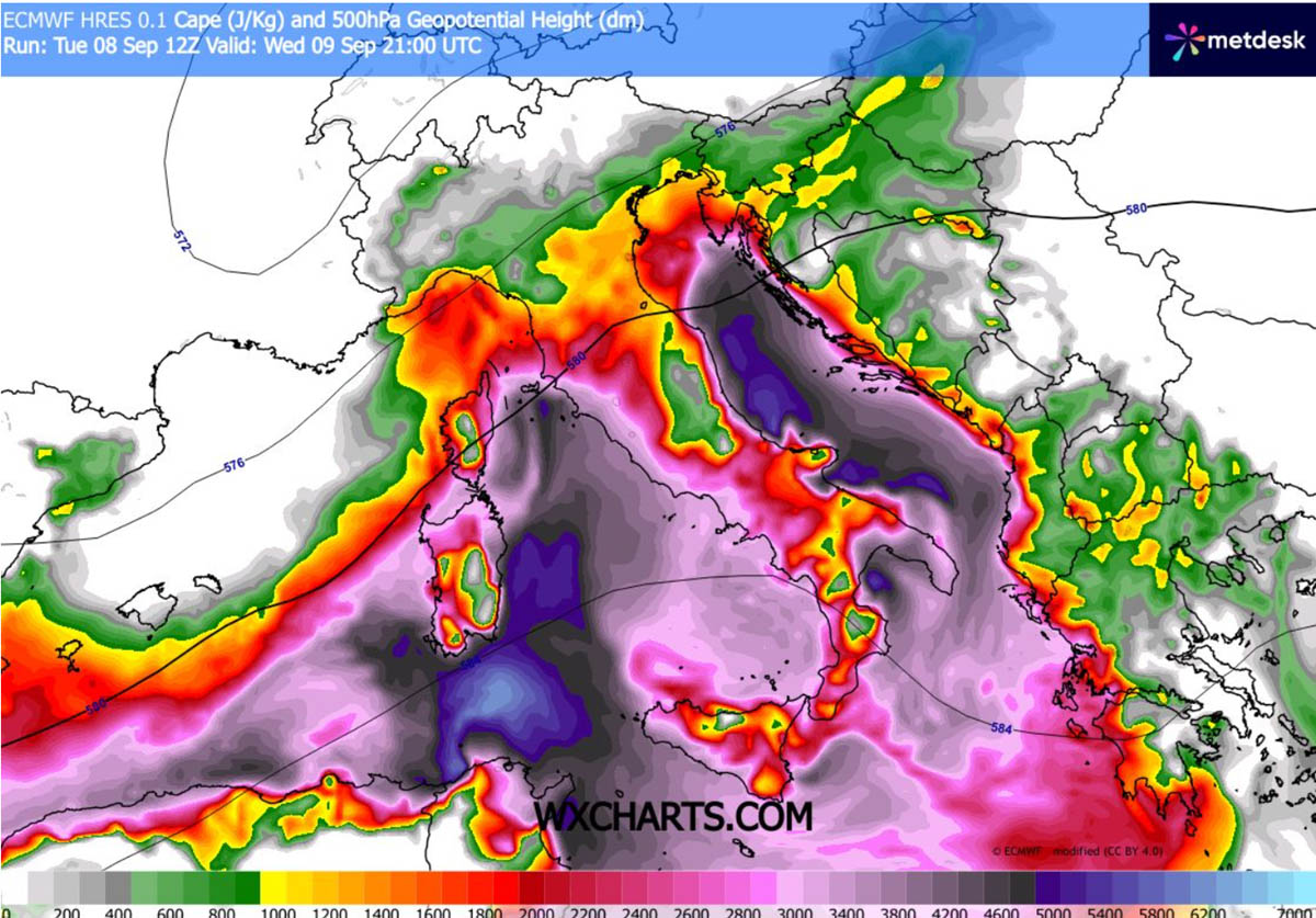
- Extreme Moisture Flux: The ongoing Mediterranean marine heatwave has resulted in dewpoints hovering near or above 25°C. This extreme humidity provides the "fuel" for the storms. When this moisture meets the cooling air of the encroaching upper-level trough, the resulting updrafts are exceptionally vigorous.
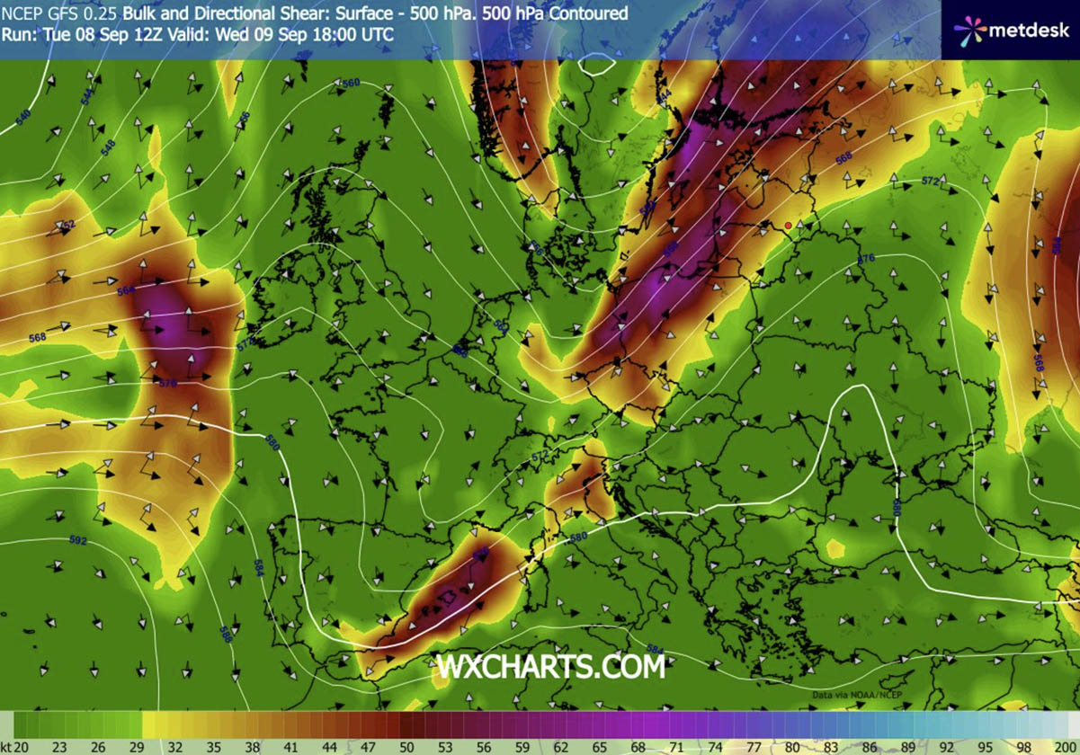
- Dynamic Wind Shear: A strong mid-level jet stream is overspreading the region, providing the necessary wind shear to organize these storms into long-lived, rotating supercells. The "left exit region" of this jet stream is providing strong synoptic-scale forcing, which is expected to trigger the initial storm development along the cold front.
The spatial extent of the "High Risk" zones reflects the confidence of the forecasting team that the combination of these variables will lead to a high-impact event. The use of the "High" classification is reserved for scenarios where the probability of significant damage is elevated and widespread.
Official Guidance and Public Safety Implications
The severe weather threat extends beyond simple wind or rain. The specific combination of risks—particularly the potential for giant hail and tornadoes—requires immediate attention from local authorities and the public.
- Infrastructure Stress: The forecast of 200–300 mm of rain is significant enough to overwhelm local drainage systems, especially in urban centers where soil saturation and impermeable surfaces can lead to rapid runoff.
- Travel and Logistics: Major transport corridors through the Alps and across the northern Italian plains are likely to face significant disruptions. High-profile vehicles and aviation are at risk from severe wind shear and convective turbulence.
- Emergency Preparedness: Residents in the identified "High" and "MDT" (Moderate) risk zones are urged to monitor local meteorological services closely. It is essential to have a plan for seeking shelter if a severe thunderstorm warning is issued for their specific area.
In the aftermath of these storms, the secondary threat of landslides in the mountainous regions of Italy, Slovenia, and Croatia cannot be ignored. The combination of intense rainfall on steep, drought-affected terrain significantly elevates the risk of debris flows.
Long-Term Implications of the 2026 Event
This weather event serves as a stark reminder of the changing dynamics in the Mediterranean region. The persistence of marine heatwaves—now a recurring feature of the late summer—acts as a catalyst for increasingly volatile weather patterns. By pumping vast amounts of heat and moisture into the lower atmosphere, these heatwaves effectively "supercharge" cold fronts that would otherwise produce more moderate weather.
As this system traverses the heart of Europe, the meteorological community will be watching closely to see if the reality of the event matches the high-resolution model outputs. The data currently points to a significant, potentially historic, two-day outbreak.
Stay Informed:
Residents and travelers in Spain, France, Italy, Austria, Slovenia, and Croatia are advised to follow the latest updates from their national weather services. Severe Weather Europe will continue to provide real-time tracking and analysis of the convective development throughout the duration of the event. Please ensure you have multiple ways to receive emergency alerts and avoid unnecessary travel during the peak of the storms.