By Mika Rantanen
Published: August 20, 2026
The summer of 2026 will be remembered in Finland not for its heatwaves, but for its deluge. Across the country, extreme weather has manifested in the form of intense, localized downpours that have overwhelmed drainage systems, flooded residential streets, and even caused the collapse of critical infrastructure, including bridges. As meteorological data continues to pour in, experts are observing a troubling trend: the "once-in-a-century" storm is becoming a disturbingly regular occurrence.
The Anatomy of a Downpour
When we talk about extreme rainfall, the metrics often feel abstract until they translate into reality. In meteorological terms, a daily rainfall exceeding 100 millimeters at a single location is considered a rare event, statistically occurring once every hundred years or less. However, when viewed through the lens of the entire country, such extreme events are being recorded with increasing frequency—often annually.
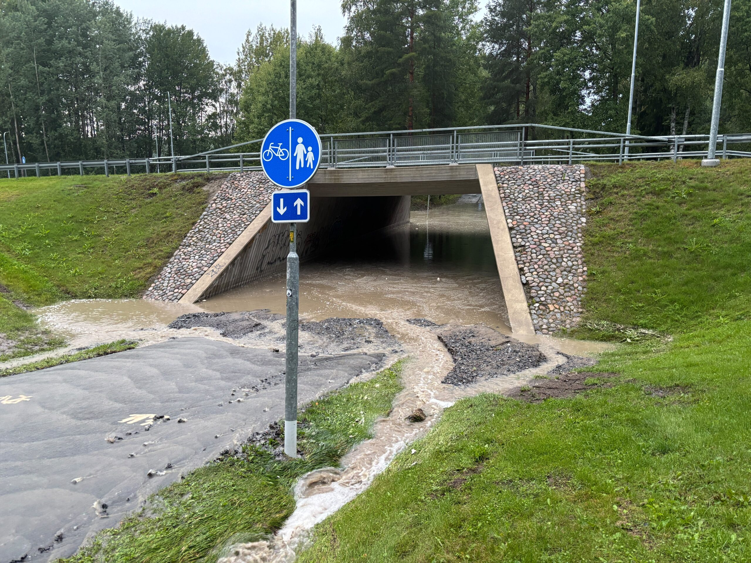
This summer, the intensity of these events has been stark. Last week, the town of Seinäjoki became the epicenter of such a weather event, with neighboring areas like Tampere experiencing significant flash flooding. These are not merely heavy rains; they are atmospheric events capable of causing structural damage and severe disruption.
To understand the severity, we look to the Finnish Meteorological Institute (FMI) standards. The lowest warning threshold (yellow) is triggered by 20 mm of rain in an hour or 50 mm in a day. On Sunday, August 16, 2026, the Pelmaa station in Seinäjoki recorded a staggering 68.6 mm of rain in just one hour, with a daily total reaching 107.7 mm. Under different circumstances, this level of precipitation would have warranted a red-level warning—the highest tier of severity. This was not an isolated incident; on July 18, 2026, the region of Multia also recorded a daily rainfall total exceeding 100 mm.
Chronology of the 2026 Deluge
The summer of 2026 has been marked by a shift in atmospheric behavior. While the public often focuses on temperatures, the true story of this season lies in the water.
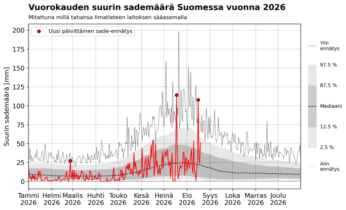
- Late February: An unseasonably heavy winter rain event occurred, yielding over 25 mm of precipitation, setting a new daily record for that specific date.
- July 18, 2026: A major weather system stalled over Multia, resulting in 114.2 mm of rain in 24 hours at the Karhila station.
- August 16, 2026: The Seinäjoki-Pelmaa event occurred, bringing 107.7 mm of rain. This event is particularly notable as it stands as the latest in the season that such a high volume of rain has been recorded in Finland’s measurement history.
These events highlight a shift toward more volatile, high-impact weather systems that arrive with little warning and deliver massive volumes of water in compressed timeframes.
Data Analysis: Distinguishing Local vs. National Rarity
To grasp the significance of these 100 mm rainfall events, we must distinguish between the probability of such an event occurring at a specific location versus its probability of occurring anywhere in Finland.
Using data from the Ilmasto-opas (Climate Guide) recurrence tables, we can estimate the rarity. For a location like the Kauhava airport, the 100-year recurrence level for a 24-hour rainfall is 84 mm, while the 500-year level is 114 mm. Because Seinäjoki shares a similar climatic profile, we can infer that the recent rainfall event there was a "100-to-500-year event." For an individual living in that region, experiencing such a deluge is a once-in-a-lifetime occurrence.
However, when we zoom out to a national scale, the narrative changes. The FMI has spent recent years digitizing over a century of weather observations. When we plot the annual maximum daily rainfall anywhere in Finland against the historical "climatology" from 1900 to 2025, a clearer picture emerges.
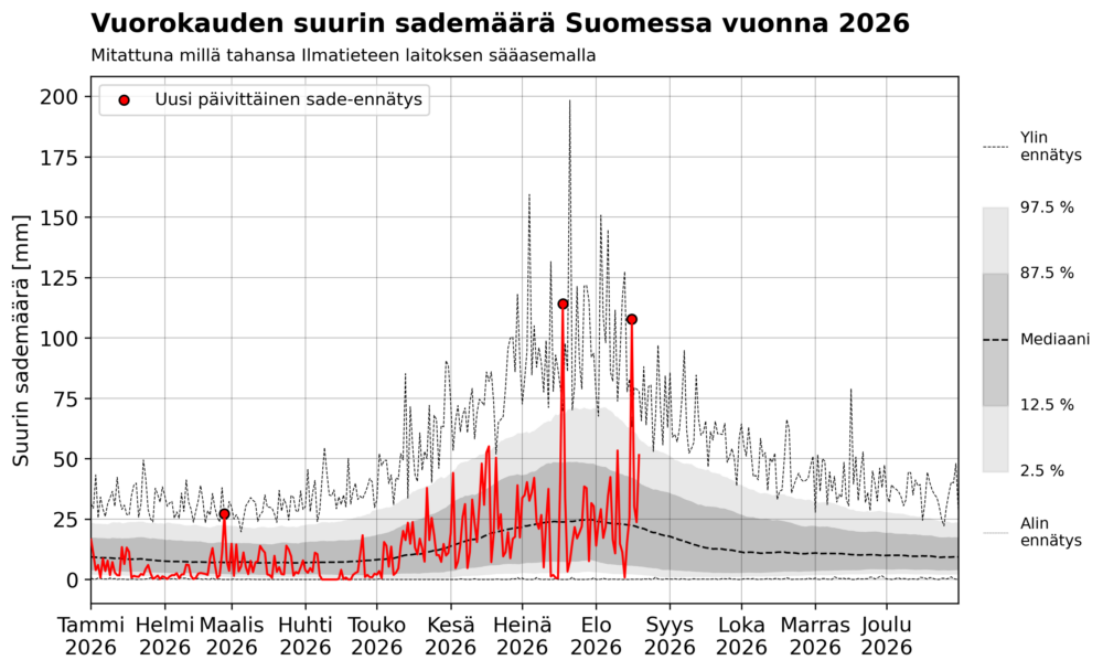
Historically, these extreme events are confined to the period between late June and mid-August. The all-time Finnish record—198.4 mm in Espoo, Lahnus, on July 21, 1944—sits right in the middle of this "peak" window. Our analysis shows that 100 mm daily totals occur, on average, once every five years somewhere in the country. But in the current era, the frequency has surged.
The Accelerating Trend
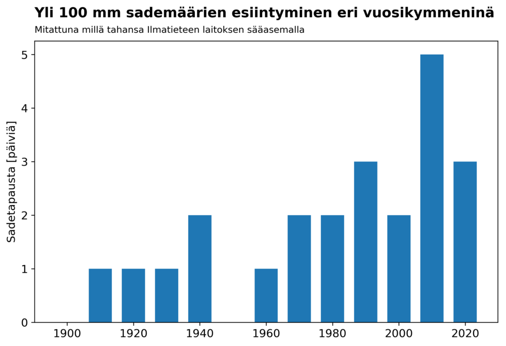
When we examine the distribution of these 100 mm events by decade, the data is compelling. From 1910 to 2026, there have been 23 such events.
- 2010–2019: Five events were recorded.
- 2020–2026 (partial decade): Three events have already occurred.
Within the last 17 years, we have seen eight of these extreme events, meaning they are now occurring nearly every other year. While the expansion of the FMI’s weather station network and the ongoing digitization of older, handwritten records may account for some of this perceived increase, the trend is consistent with the predictions of climate change models.
It is important to note that only four years in the last century (2004, 2011, 2018, and 2026) have experienced multiple 100 mm rainfall days. The fact that 2026 has already seen two such days makes it a statistical anomaly of significant proportions.
Official Perspectives and Future Implications
The scientific community is increasingly vocal about the link between a warming atmosphere and extreme precipitation. According to the Clausius-Clapeyron relation, a warmer atmosphere can hold more moisture—roughly 7% more for every degree Celsius of warming. This physics-based reality is the engine behind the heavier downpours observed in recent years.
A recent study by the Finnish Meteorological Institute projects that the frequency of the most intense, short-duration rains (over 20 mm per hour) will double by the end of the century under the RCP4.5 emission scenario. If global warming exceeds current projections, the increase in these events could be even more dramatic.
The implications for civil engineering and urban planning are profound. Our current infrastructure—sewers, culverts, and bridges—was largely designed based on historical climate data from the 20th century. As the "new normal" trends toward more frequent 100 mm days, the current designs are proving insufficient. Cities like Tampere and Seinäjoki are essentially testing grounds for the resilience of our built environment against a changing climate.
Conclusion: Preparing for a Wetter Future
The data from 2026 serves as a sobering reminder that extreme weather is no longer a distant threat but a present challenge. While the rarity of a 100 mm rainfall event at a specific spot remains high, the national probability is climbing.
We must move beyond the mindset that these are "freak" accidents. Instead, they should be viewed as part of a coherent, long-term trend driven by global climatic shifts. As we look toward the future, the integration of high-resolution climate modeling into urban planning will be essential to mitigate the damage caused by the increasingly frequent, heavy, and destructive rains that are defining the Finnish summer.
The question is no longer if we will see another 100 mm rainfall day, but rather how well we can prepare our infrastructure to withstand the next inevitable deluge.