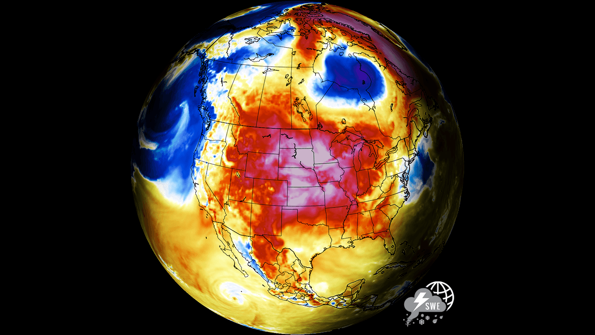
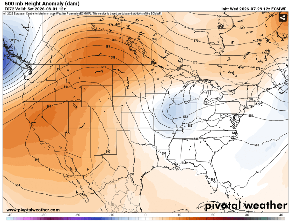
As the calendar turns toward August, a formidable atmospheric blockade has settled over the North American continent. A high-amplitude upper-level ridge, behaving with the relentless stability of a classic "Heat Dome," has locked a massive plume of scorching air across the United States, extending its reach into southern Canada. This synoptic feature is not merely a transient warm spell; it is an engine of extreme thermal anomalies, pushing temperatures into the 99th percentile and creating a multi-week hazard for millions of residents.
With peak afternoon temperatures consistently climbing between 105°F and 110°F across the Southwest and central plains—and desert basins flirting with a staggering 120°F—the situation has triggered urgent warnings from meteorological agencies. This article examines the mechanics of this extreme event, the human and infrastructural costs, and the projected timeline for this atmospheric siege.
The Mechanics of the "Heat Dome": An Atmospheric Lid
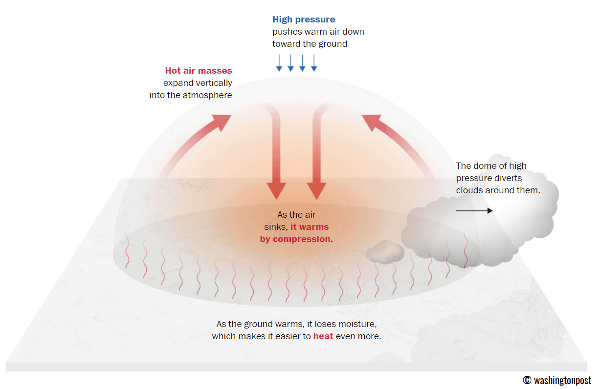
To understand the current crisis, one must look at the atmospheric dynamics at play. A heat dome occurs when a high-pressure system becomes anchored in place, effectively acting as a lid on a pot. This phenomenon, technically referred to as an "upper-level ridge" or "blocking high," prevents the natural dispersion of heat.
Under this dome, the air is not merely stagnant; it is actively compressed. As the high-pressure system exerts downward force, the air sinks, warming adiabatically as it descends toward the surface. This creates a feedback loop: the sinking air dries out the surface, clearing away cloud cover, which in turn allows more solar radiation to penetrate and heat the ground, further strengthening the ridge.
This "lid" traps heat at all levels of the atmosphere. The result is a consistent, oppressive thermal environment that does not relinquish its grip at night. When nocturnal cooling—the natural process by which the Earth releases the day’s heat—is stifled, the physiological toll on humans, animals, and infrastructure grows exponentially.
Chronology of the Event: A Multi-Week Siege
The current heatwave is characterized by its remarkable persistence. While most weather patterns shift within days, the current ridge has displayed an unusual "stickiness."
Early Stages: The Southwest Ignition
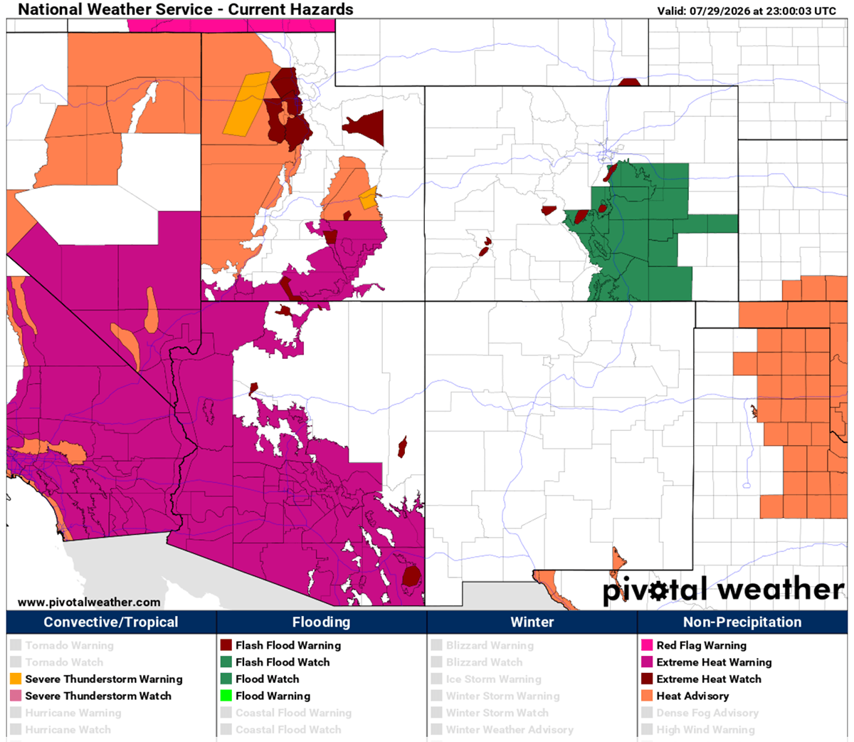
The heat wave began in earnest across the desert Southwest. California, Arizona, and Nevada were the first to experience the brunt of the dome, with temperatures rapidly exceeding seasonal norms. By mid-week, cities in the desert basins were already recording highs of 115°F to 120°F.
The Mid-Week Expansion: Crossing the Great Plains
As the ridge strengthened, it expanded eastward, extending its influence from the Rocky Mountains into the central Great Plains. By Thursday, the thermal anomaly shifted to encompass Texas, Oklahoma, and Kansas. Temperatures in these regions began a steady climb into the 100°F–105°F range, marking a significant departure from typical late-July climate averages.
The Weekend Peak: Montana to the Dakotas
Forecasters indicate that the peak of the heat dome’s intensity will likely occur between Friday and Sunday. During this window, the ridge is expected to consolidate its core over Montana, Wyoming, and the western Dakotas. Models suggest that surface temperatures in these regions could spike to 110°F—a dangerous level for areas unaccustomed to such extreme heat.
The Early August Outlook: A Potential Shift
The current forecast models suggest that this endurance test will begin to fracture by early next week. A frontal system originating from Canada is expected to track eastward, potentially providing a much-needed cooling influence on the northern High Plains by Wednesday. However, for the central and southern Plains, the reprieve may be slower to arrive, as the residual heat mass lingers over New Mexico and Texas.
Supporting Data: Thermal Anomalies and Humidity
The severity of this event is best measured through "upper-air thermal anomalies." Meteorologists monitor the 850 hPa level (roughly 5,000 feet above the ground) to gauge the temperature of the air mass before surface-level variables like vegetation or concrete alter the reading. Current charts show these anomalies are in the 99th percentile, confirming that this is an extraordinary event in the historical record.
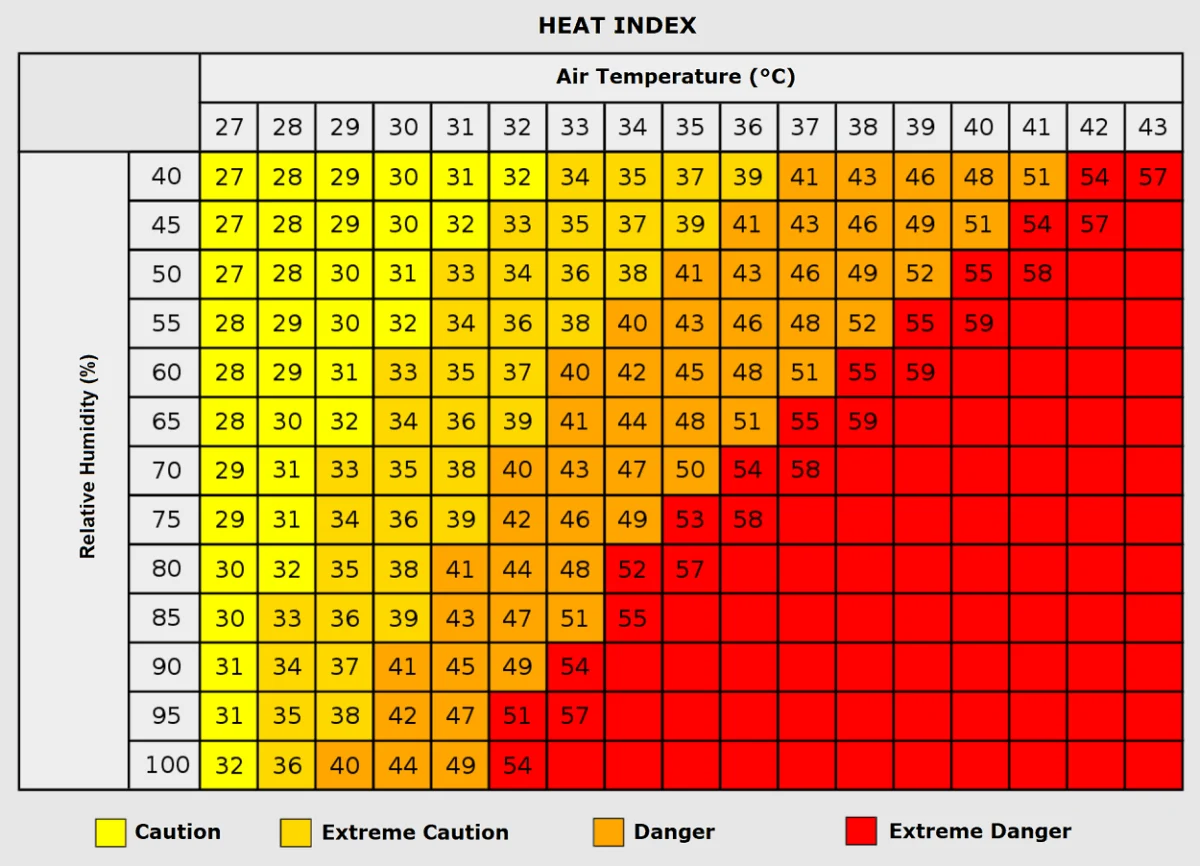
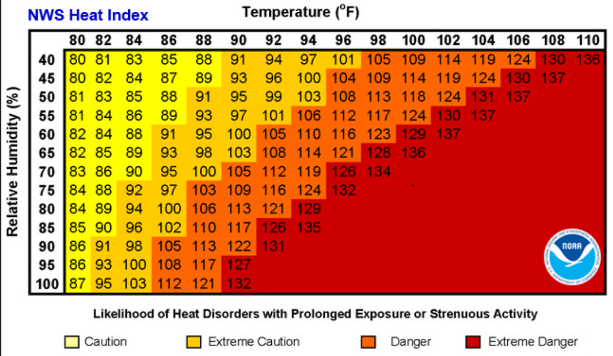
Furthermore, the "Heat Index"—a calculation that factors in relative humidity—is proving to be a critical metric. When humidity levels are high, the human body’s primary cooling mechanism, perspiration, becomes ineffective.
For instance, an ambient temperature of 90°F with 40% humidity is manageable. However, if that same temperature occurs with 80% humidity, the "feels-like" temperature can soar to 113°F. In the Mississippi Valley, where humidity is naturally higher, this creates a life-threatening environment that requires immediate precautions.
Implications: Public Health, Agriculture, and Infrastructure
The implications of a multi-week heat dome are wide-reaching, affecting nearly every facet of modern life.
Human Health: The Silent Crisis
The primary concern during such events is the impact on public health. Heat exhaustion is only the initial stage of heat-related illness; if left untreated, it progresses rapidly to heat stroke, which can be fatal. Vulnerable populations—the elderly, young children, and those with pre-existing cardiovascular or respiratory conditions—are at the highest risk.
"Nighttime heat stress" is a particularly insidious component of this event. When overnight lows fail to drop below 80°F, the human body cannot recover from the thermal stress of the day. This leads to cumulative physiological strain, increasing the likelihood of heart attacks and strokes.
Energy Grid Demand
The power grid faces an immense challenge during these heat waves. As air conditioning usage skyrockets to meet the demand of cooling millions of homes and businesses, the strain on transformers and generation capacity increases. Utility providers are frequently forced to implement demand-response protocols, and in worst-case scenarios, they must manage the risk of rolling blackouts to prevent total grid failure.
Agricultural Stress
Beyond human health, the agricultural sector is suffering from rapid soil moisture depletion. The combination of extreme heat and a lack of convective rainfall means that crops in the Great Plains are facing significant dehydration. If the heat persists through early August, the impact on yields for corn, soy, and other staple crops could be substantial, potentially rippling through food supply chains.
Official Responses and Safety Recommendations
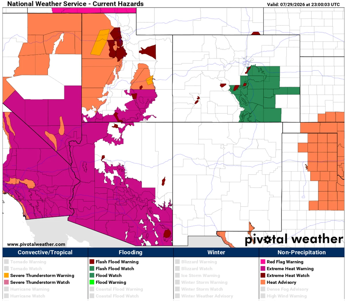
In response to the dangerous conditions, the National Weather Service and various state agencies have issued widespread Excessive Heat Warnings and Heat Advisories. Officials are urging the public to adopt the following safety measures:
- Hydration: Drink water continuously throughout the day, regardless of your thirst level. Avoid caffeine and alcohol, which accelerate dehydration.
- Strategic Cooling: Limit strenuous outdoor activities to the early morning hours. If air conditioning is unavailable, seek refuge in designated "cooling centers" or public facilities like libraries and malls.
- Wellness Checks: Check on neighbors, especially the elderly and those living alone. A brief phone call or visit can be the difference between safety and a medical emergency.
- Vehicle Safety: Never leave children or pets in a parked vehicle. In these temperatures, the interior of a car can reach lethal levels in less than ten minutes.
Conclusion: A New Normal?
As we monitor the movement of this massive heat dome, it is clear that the scale of this event is historic. The stability of the upper-level ridge and the sheer geographic extent of the affected area underscore the intensity of this summer’s weather patterns. While global weather models offer hope for a cooling trend by the middle of next week, the immediate priority remains the safety of those within the impact zone.
Meteorological agencies will continue to track the movement of the frontal systems expected to break this block. Until then, the message remains clear: this is a severe, multi-day, and potentially life-threatening event that demands caution, vigilance, and respect for the volatility of the atmosphere. Stay tuned for further updates as the data evolves and the pattern begins to shift.