As the summer of 2026 draws to a close, Europe finds itself locked in the grip of its sixth major heatwave of the season. A persistent and dangerous "Heat Dome"—a high-pressure blocking system—has parked itself firmly over the Central Mediterranean and Southern Europe, creating a meteorological furnace that is threatening to shatter late-August temperature records. With the atmospheric engine of this system showing no signs of immediate weakening, millions of residents across the continent are preparing for a period of extreme thermal stress.
The Atmospheric Engine: Anatomy of a Heat Dome
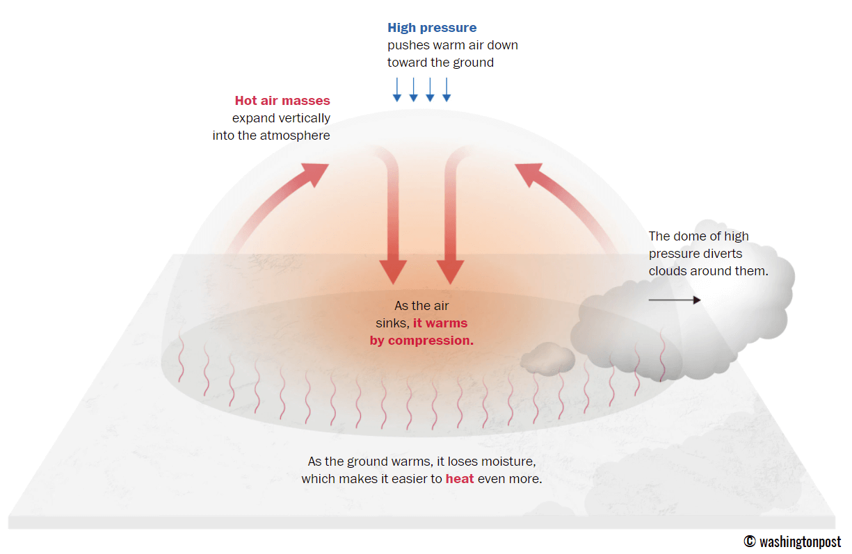
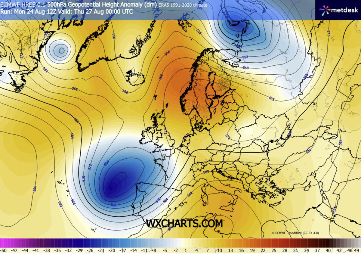
The primary driver behind this latest surge is a stubborn, large-scale ridge of high pressure that has effectively stalled over Southern Europe. In meteorological terms, this is often referred to as a "blocking high." It functions much like a lid on a boiling pot; it traps warm, stagnant air at all levels of the atmosphere and prevents the normal migration of cooler weather systems.
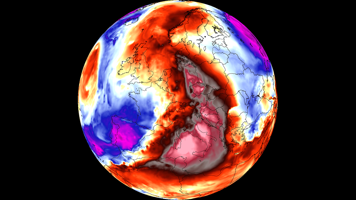
As this high-pressure cell forces air to sink, the air undergoes adiabatic compression. In this process, the sinking air becomes denser and warmer, rapidly increasing temperatures in the lower troposphere. Because the system is so stable, it is effectively "baking" the landscape, leading to extreme surface temperatures that range from 38°C to 43°C in low-lying river basins and agricultural plains. Furthermore, dry continental winds are exacerbating the situation by accelerating the loss of soil moisture, which in turn dries out vegetation and creates a tinderbox environment for wildfires.
Chronology of the Heatwave: A Week of Rising Extremes
The current meteorological trajectory indicates that the intensity of the heat will peak during the latter half of this week, before a gradual dissipation begins over the weekend.
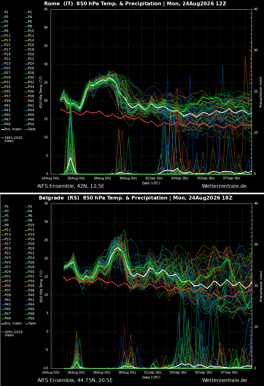
- Early Week (Monday–Wednesday): The upper-level ridge expanded from North Africa, establishing a foothold over the Mediterranean and pushing the mercury into the high 30s.
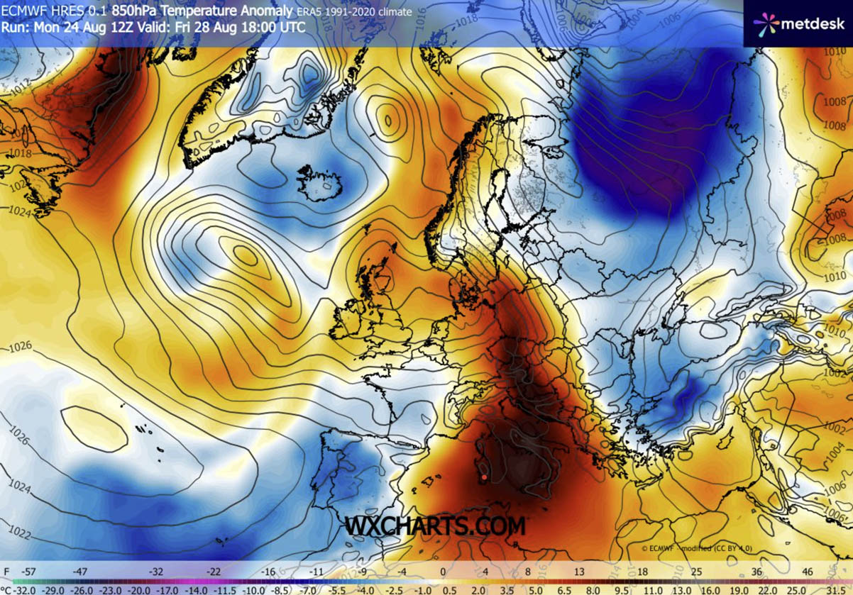
- The Peak (Thursday–Saturday): The most intense phase of the heatwave is expected during this window. Italy, the central Balkans, and parts of Central Europe will face the brunt of the thermal anomaly, with peak temperatures likely hitting the 42–43°C threshold.
- The Weekend Shift: By the end of the week, the heat dome will begin to elongate and shift eastward, moving from Central Europe toward the Balkans, Poland, and western Ukraine. Simultaneously, a maritime air mass originating from the Atlantic will push into Western and Southwestern Europe, providing a much-needed reprieve from the suffocating conditions.
Supporting Data: By the Numbers
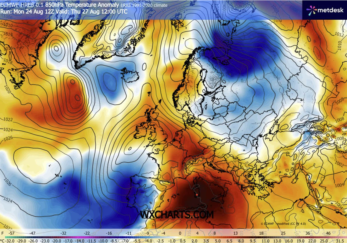
The severity of this event is best understood through the lens of temperature anomalies. Forecast models suggest that surface temperatures will be 12°C to 16°C above the long-term historical averages for late August.
In major urban corridors—including Rome, Belgrade, and various Balkan cities—the lack of nighttime cooling is a significant concern. During this heatwave, overnight temperatures are forecast to remain between 22°C and 26°C. These "tropical nights" prevent the human body from shedding the heat accumulated during the day, leading to a compounding effect of physiological stress.
Furthermore, the 850 hPa temperature maps illustrate a massive plume of heat surging from the Sahara, moving across the Mediterranean, and enveloping the heart of the continent. While the west experiences a cooling trend due to Atlantic influence, the "omega block" pattern ensures that the central and eastern regions remain trapped in a persistent cycle of intense heat.
The Dual Threat: Severe Thunderstorms and Infrastructure Strain
While the heat remains the primary headline, the synoptic setup is creating a volatile environment for severe weather. On Thursday, a significant pressure and temperature gradient will develop between the heat dome in the east and a deep, cold-core wave moving into western Iberia.
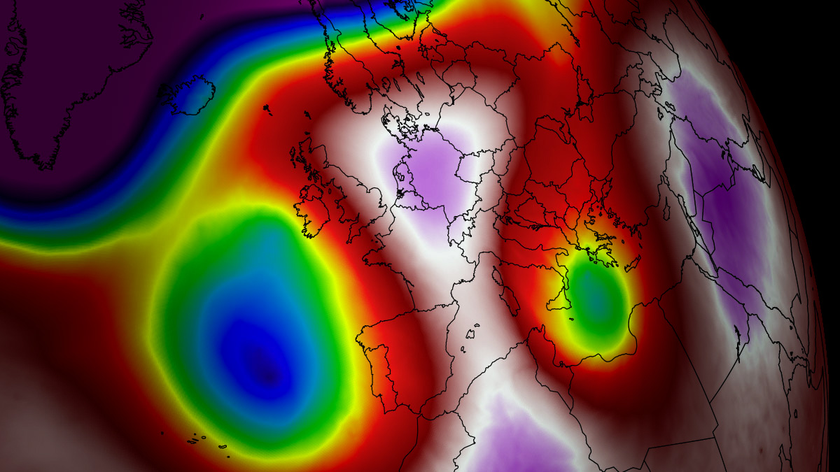
This interaction will trigger a violent response in France and the western Alps. The influx of maritime air against the stagnant heat will generate extreme instability, with Convective Available Potential Energy (CAPE) values ranging from 3,000 to 5,000 J/kg. This energy, combined with strong vertical wind shear, sets the stage for a potential outbreak of severe supercell thunderstorms. These storms are expected to be highly organized, capable of producing giant hail, localized tornadoes, and torrential rainfall that could cause flash flooding in areas already parched by drought.
Implications for Public Health and the Economy
The implications of this prolonged thermal surge extend far beyond uncomfortable weather. Public health officials across Europe are on high alert, as heatwaves of this magnitude are historically linked to spikes in cardiovascular, respiratory, and renal illnesses.
Vulnerable Populations
The most at risk are the elderly, children, and those with pre-existing chronic conditions. However, the economic impact is also significant. Construction workers, agricultural laborers, and transport staff face an increased risk of heat exhaustion and heatstroke. In urban areas, the "urban heat island" effect—caused by concrete and asphalt absorbing and re-radiating heat—makes cities significantly hotter than the surrounding countryside. This forces energy grids to the brink of failure as demand for air conditioning skyrockets, raising the risk of widespread blackouts.
The "Heat Index" Reality
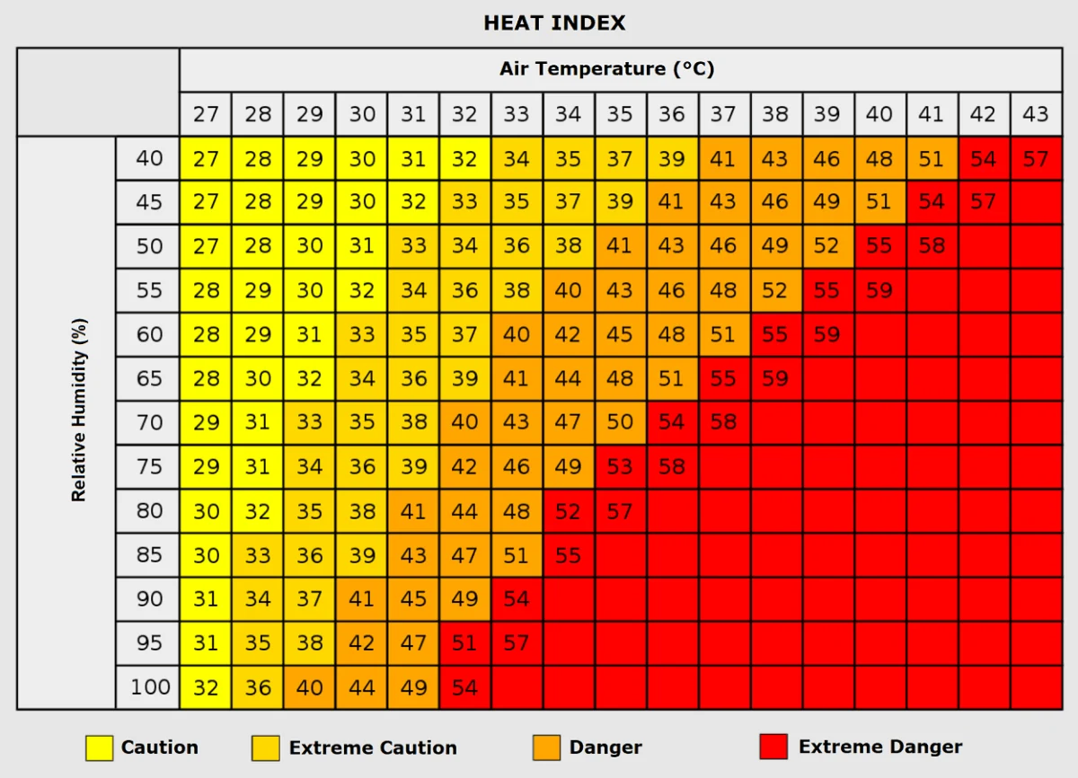
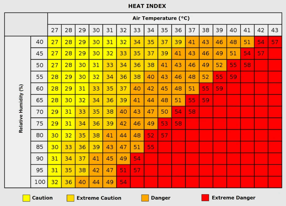
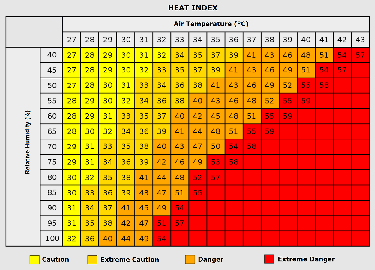
Meteorologists emphasize that the raw temperature is only part of the story. The "Heat Index," which factors in relative humidity, provides a more accurate picture of the physiological danger. When temperatures reach 35°C, even moderate humidity levels can make the "feels-like" temperature climb toward 50°C. In such conditions, the human body’s primary cooling mechanism—sweating—becomes inefficient, leading to rapid dehydration and the potential for life-threatening heatstroke.
Official Responses and Adaptive Strategies
As the continent grapples with its sixth heatwave of the season, national meteorological agencies have issued "Red Level" warnings across Italy, Serbia, Croatia, and Hungary.
Government authorities have implemented emergency protocols, including:
- Cooling Centers: Opening public buildings with climate control for those without access to air conditioning.
- Labor Restrictions: Enforcing bans on outdoor heavy labor during the peak sunlight hours of 12:00 PM to 6:00 PM.
- Grid Management: Coordinating with utility companies to ensure base-load power remains stable during the surge in demand.
- Wildfire Preparedness: Pre-positioning firefighting assets in high-risk, drought-stricken valleys where the dry, hot winds pose an explosive risk for fire ignition.
A Changing Climate Pattern?
The frequency and intensity of these heat domes in 2026 have sparked intense debate among climate scientists. While single events are difficult to attribute entirely to climate change, the recurring nature of these "blocking" patterns—where high-pressure systems remain anchored for longer durations—is consistent with models predicting a more volatile atmosphere.
The "split-flow" pattern observed this season, characterized by deep, cold waves clashing with extreme heat ridges, suggests that the jet stream is becoming increasingly erratic. As the continent looks toward the fall, the transition period remains uncertain. Long-range models are currently analyzing how this summer’s thermal energy will influence the upcoming autumn, with many meteorologists warning that the "dynamic and warm" pattern may persist well into September.
Conclusion: Staying Vigilant
As the heat dome reaches its zenith, the best defense remains vigilance. Residents in the affected regions are encouraged to limit outdoor activity, stay hydrated, and check on vulnerable neighbors. The meteorological data is clear: this is not merely a temporary summer spike, but a significant, multi-day event that requires serious caution.
As the weekend approaches and the maritime air provides some relief to Western Europe, those in the Balkans and Eastern Europe must remain prepared for the heat’s eastward shift. The 2026 season has proven to be a test of endurance for the continent, and with another few days of record-breaking potential remaining, the focus remains on minimizing health impacts and navigating the severe weather risks that follow in the wake of the heat.