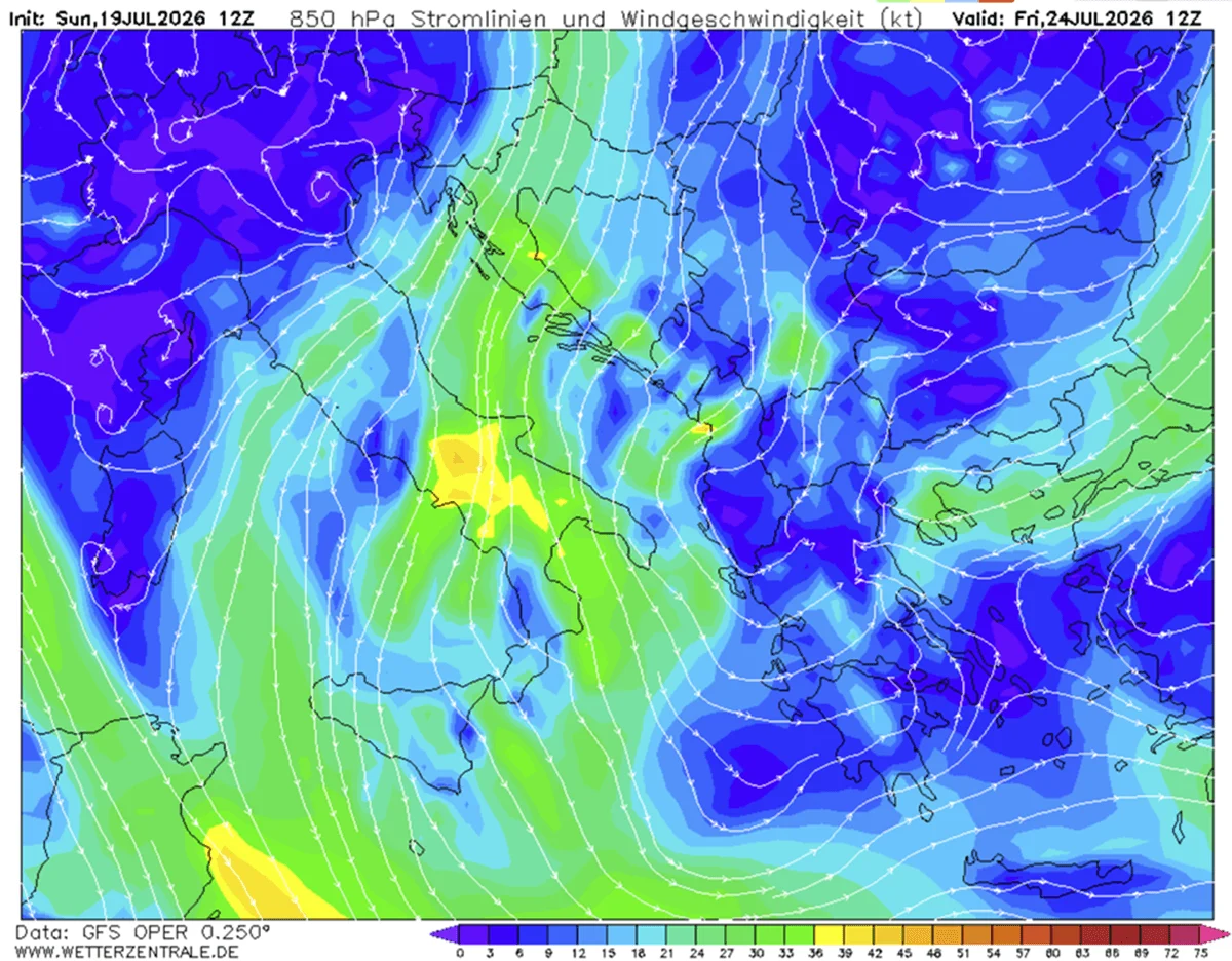
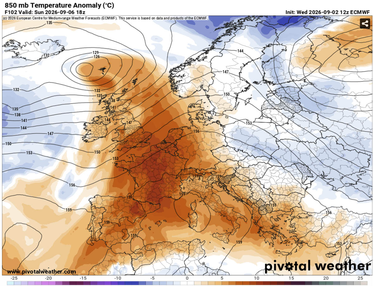
As the calendar turns to September, most of Europe typically anticipates the gentle onset of autumn—a cooling of the Mediterranean breezes and the first hints of amber in the deciduous forests. However, 2026 is delivering a starkly different reality. A massive, high-pressure "Heat Dome" is currently anchoring itself over the European continent, promising an intense, late-season heatwave that threatens to shatter temperature records across Southern, Western, and Central Europe.
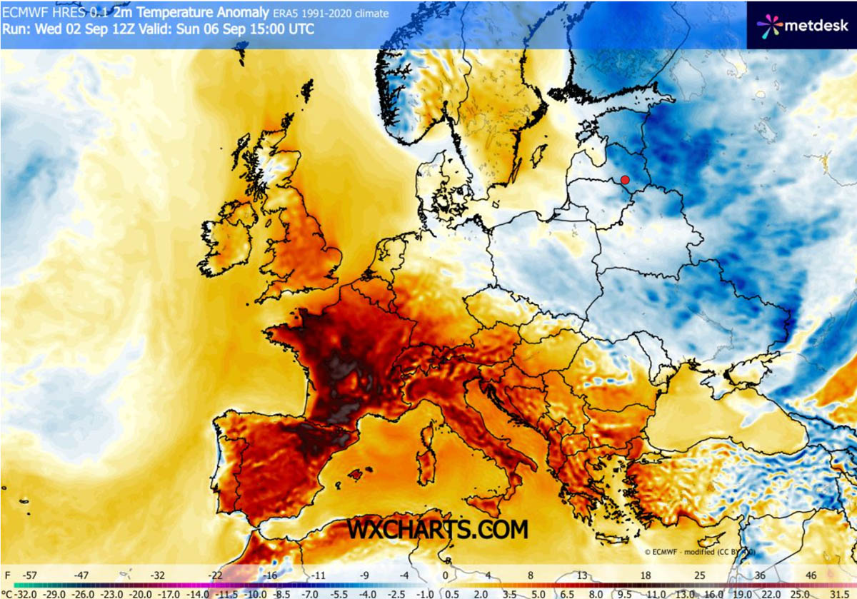
Meteorological models indicate that surface temperatures will climb into the high 30s (°C), with localized pockets in the Mediterranean Basin and the Iberian Peninsula projected to exceed the blistering 40°C threshold. Driven by a relentless plume of warm air surging from the North African desert, this weather pattern is not merely a brief spike; it is a sustained thermal event that poses significant risks to infrastructure, energy grids, and public health.
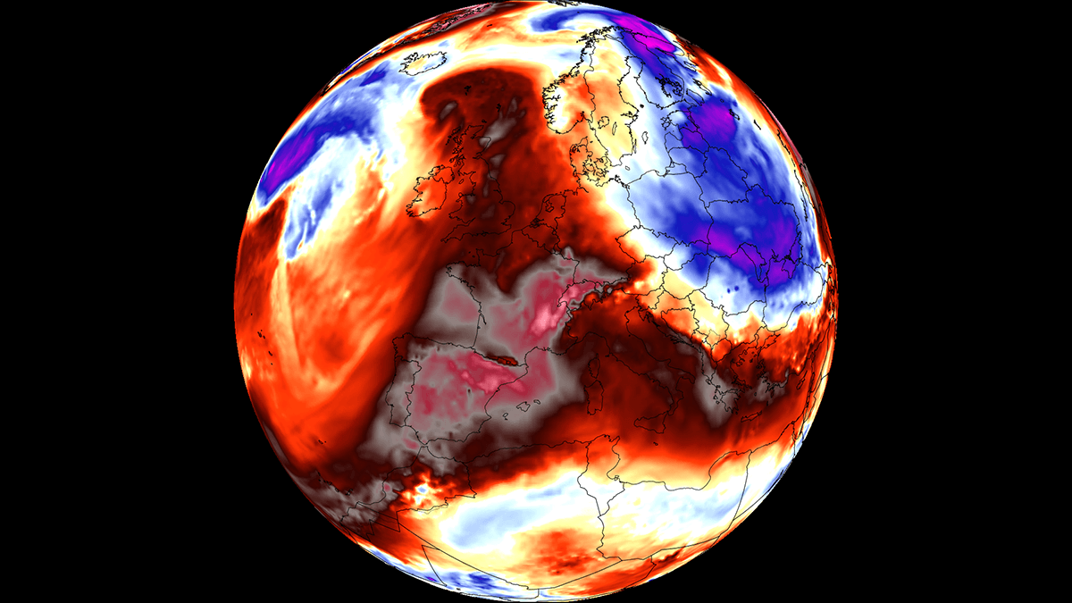
The Synoptic Setup: Anatomy of a Heat Dome
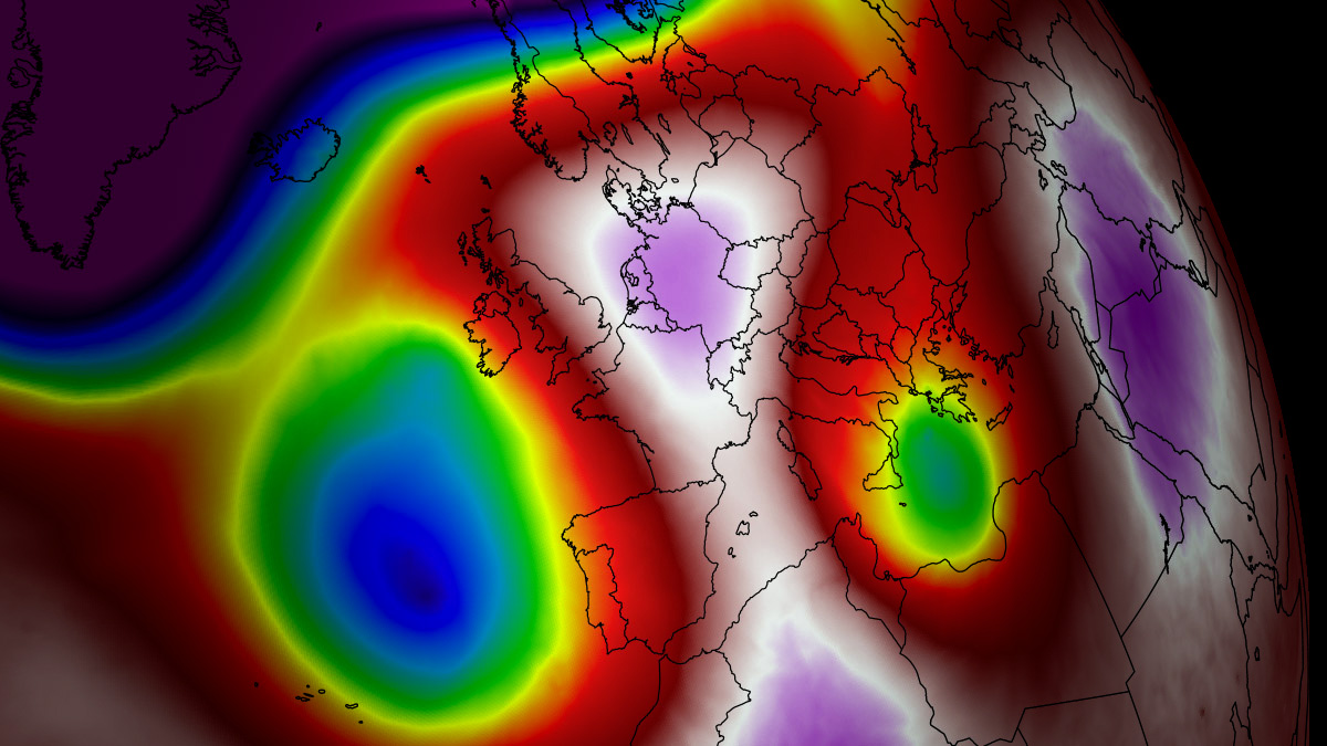
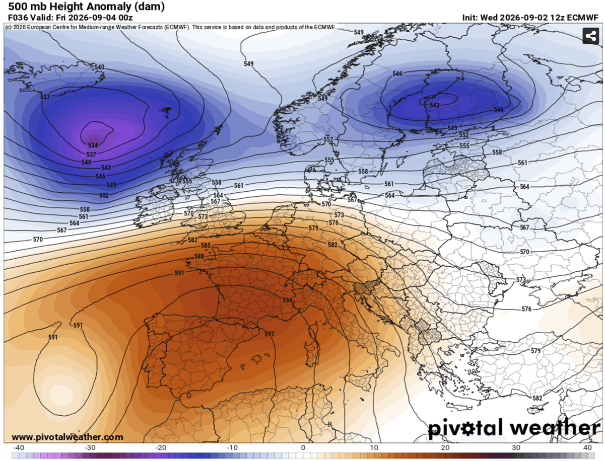
To understand the severity of this event, one must look at the atmospheric dynamics at play. The current phenomenon is defined by a blocking high-pressure system—an "Upper High"—that has effectively parked itself over the Mediterranean.
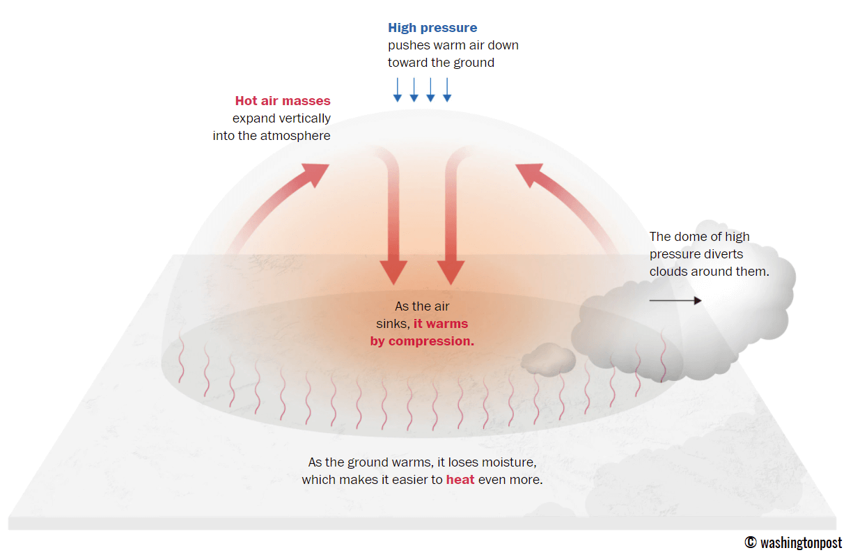
In meteorology, a heat dome functions much like a lid on a boiling pot. High-pressure systems in the upper atmosphere force air to sink toward the surface. As this air descends, it undergoes adiabatic compression; as the pressure increases, the air molecules collide more frequently, causing the temperature to rise significantly. Because this high-pressure ridge is stagnant, it prevents the circulation of cooler maritime air, effectively trapping the heat within the lower levels of the atmosphere.
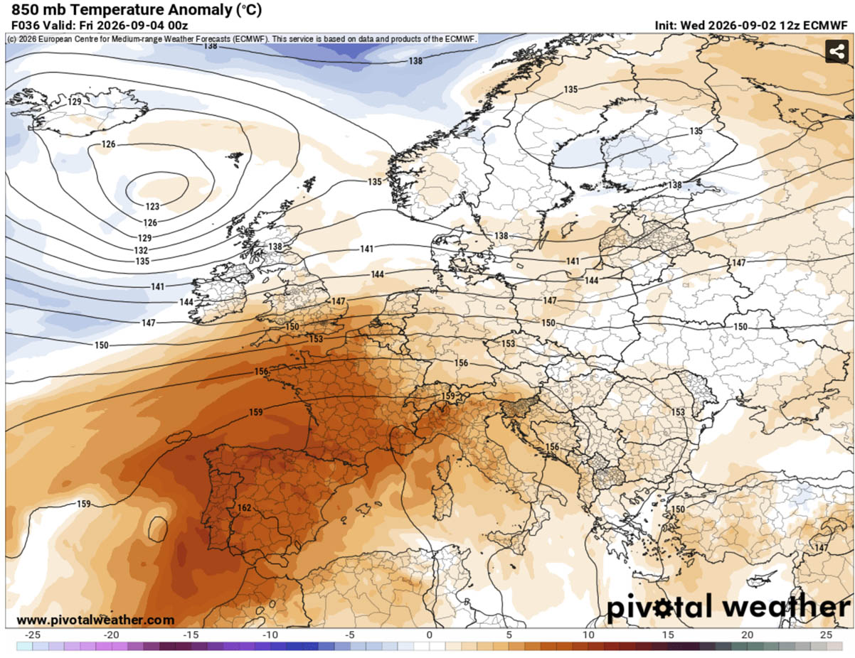
This "omega block" pattern, named for its resemblance to the Greek letter Ω on weather maps, creates a stagnant environment where the air mass becomes increasingly anomalous over several days. While summer heat is common in the Mediterranean, the timing of this event—well into September—is statistically significant. The sun angle is lower than in July, yet the sheer intensity of the thermal ridge is compensating for the reduced daylight, driving temperatures 10°C to 14°C above long-term seasonal averages.
A Chronology of the Thermal Siege
The trajectory of this heatwave is structured in three distinct phases as the ridge expands and shifts:
Phase 1: The Iberian Onset (Thursday–Friday)
The initial brunt of the heat is focused on Spain and Portugal. Driven by a dry, continental air mass, temperatures in south-central regions are forecast to reach between 40°C and 44°C. These conditions are exceptionally dry, which accelerates the depletion of soil moisture—a critical factor for wildfire prevention.
Phase 2: The Continental Expansion (Weekend–Monday)
By the weekend, the heat dome will expand its footprint. The ridge will push northward into France, where southern and central regions can expect temperatures in the high 30s. Simultaneously, the heat will shift eastward, engulfing Italy and the Balkan Peninsula. During this period, the Po Valley in northern Italy and the interior of the Balkans are expected to challenge early September record highs, with peak afternoon temperatures frequently touching the 38°C to 41°C range.
Phase 3: The Northern Periphery (Throughout the Weekend)
While the core of the heat is focused south, even the British Isles will feel the effects of the ridge. South-central England and Wales will see daytime highs climb into the mid-to-upper 20s, a notable departure from standard early September norms, though they will escape the life-threatening extremes seen further south.
Supporting Data: Why Nocturnal Relief is Vanishing
One of the most alarming aspects of this heatwave is the disappearance of "nocturnal cooling." In a typical weather cycle, the earth radiates heat back into space after sunset, allowing temperatures to drop to comfortable levels. However, the current heat dome creates a "blanket effect."
Forecasts suggest that across major urban corridors, nighttime lows will refuse to drop below 22°C to 25°C. These are classified as "tropical nights." Without this vital window of recovery, the human body is unable to dissipate the thermal stress accumulated during the day. For vulnerable populations, particularly in cities characterized by the "urban heat island" effect—where concrete and asphalt store and radiate heat—this lack of nocturnal relief significantly increases the risk of heat-related mortality.
Public Health and Infrastructure Implications
The implications of this late-season surge extend far beyond mere thermometer readings. Meteorological experts and public health officials have issued warnings regarding several key areas:
Health Risks and Heat Index
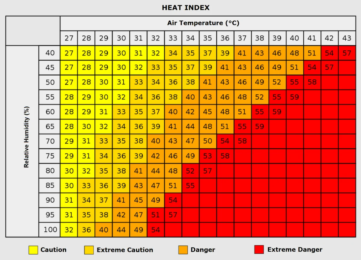
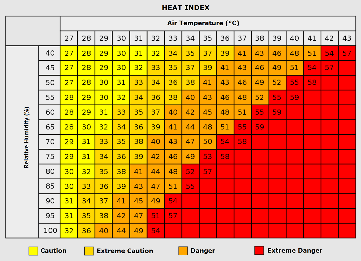
The "Heat Index"—a measurement that accounts for both temperature and relative humidity—will be a critical metric during this event. When humidity is high, the human body’s primary cooling mechanism, sweating, becomes less efficient. If humidity levels reach 80% with an ambient temperature of 35°C, the "feels-like" temperature can soar to near 50°C. Prolonged exposure under such conditions leads to rapid dehydration, heat exhaustion, and potentially heat stroke. Health authorities are urging citizens to limit outdoor activity during peak hours (12:00 PM to 6:00 PM) and to prioritize hydration.
Grid Stability and Energy Demand
As temperatures climb, the demand for cooling—air conditioning and industrial refrigeration—will put unprecedented strain on European energy grids. The combination of high demand and the potential for lower-than-average wind speeds (a common trait of high-pressure systems) creates a challenging environment for energy providers. Grid operators are currently monitoring the situation to prevent localized brownouts, particularly in regions where the energy mix relies heavily on renewables that may be temporarily underperforming due to the stagnant air.
The Wildfire Factor
The prolonged duration of this heatwave, combined with the dry continental winds, has created a "tinderbox" scenario across the mountain slopes of Southern Europe. Dried vegetation, already stressed by a long summer, is now highly susceptible to ignition. Regional forestry services across the Balkans and Italy are on high alert, as even a small spark can lead to rapidly spreading wildfires that are difficult to contain under these meteorological conditions.
Looking Toward the "Pattern Flip"
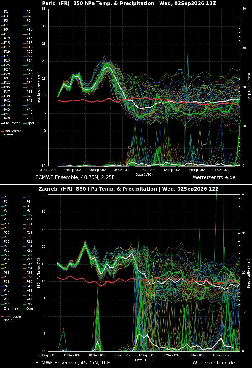
Meteorologists are already eyeing a potential shift in the synoptic pattern for the middle of next week. Ensemble model trends suggest that a deep low-pressure wave, currently brewing in the North Atlantic, will eventually push against the ridge.
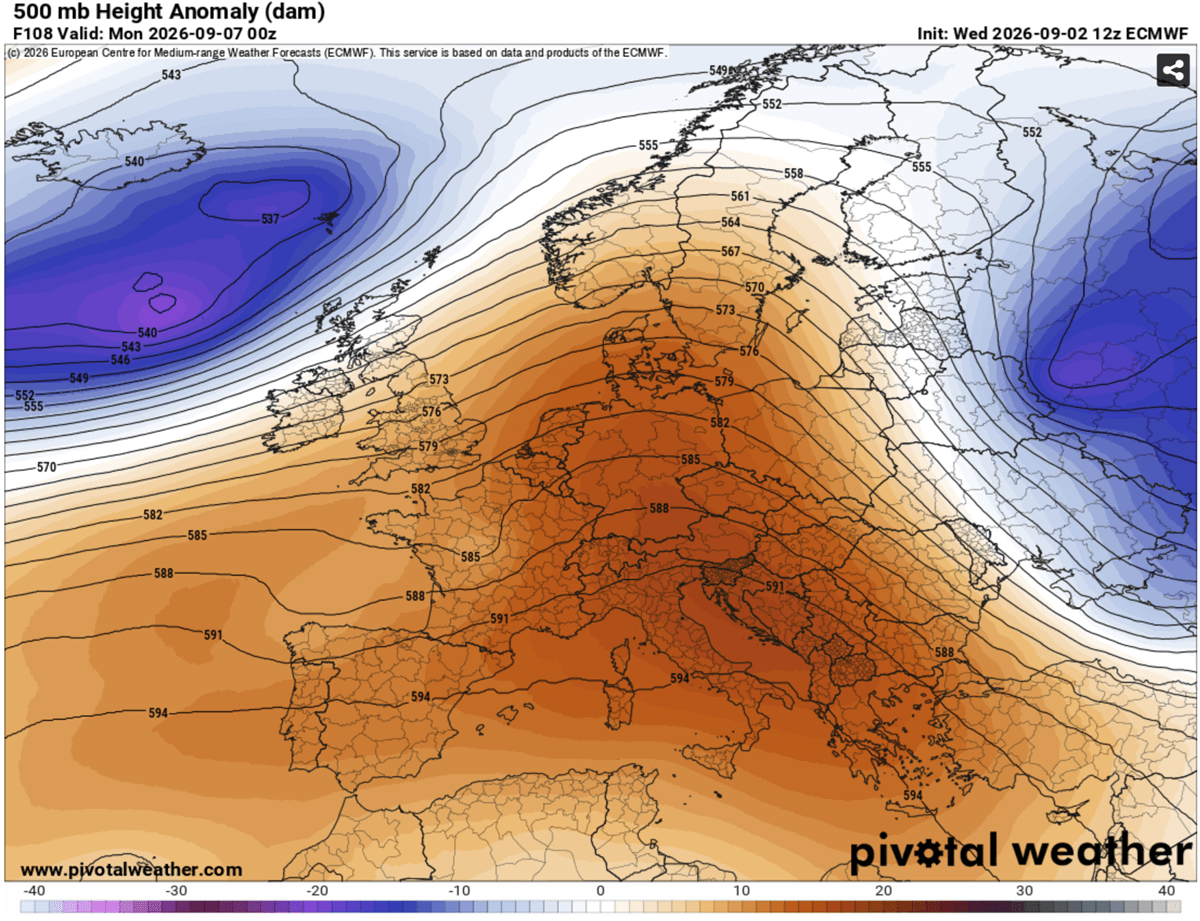
This transition is expected to be dynamic, potentially bringing an end to the heatwave by next Wednesday. The arrival of this Atlantic air mass is forecasted to usher in a period of cooler temperatures, widespread rainfall, and, potentially, severe convective weather as the cold air interacts with the residual heat trapped over the continent.
While this "pattern flip" promises a welcome respite, it also highlights the volatility of modern European weather. The intensity of this September heat dome underscores the growing concern among climatologists regarding the frequency and severity of late-season thermal extremes.
Conclusion: A Changing Climate Norm
As the continent maneuvers through this challenging week, the 2026 September heat dome serves as a poignant reminder of the evolving nature of European weather. The ability of the atmosphere to sustain such intense high-pressure blocks well into the autumn months is a subject of ongoing study.
For now, the priority remains immediate: monitoring local meteorological updates, adhering to public health guidance, and ensuring that those most vulnerable—the elderly, the chronically ill, and outdoor laborers—are protected from the unrelenting thermal stress. As the ridge eventually breaks and the cool air returns, Europe will be left to assess the impacts of a week that has redefined expectations for the end of the summer season.
For the latest updates on the transition toward cooler weather next week, citizens are encouraged to follow official national weather service warnings and rely on real-time meteorological data from organizations like PivotalWeather and WXcharts.