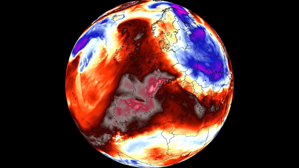
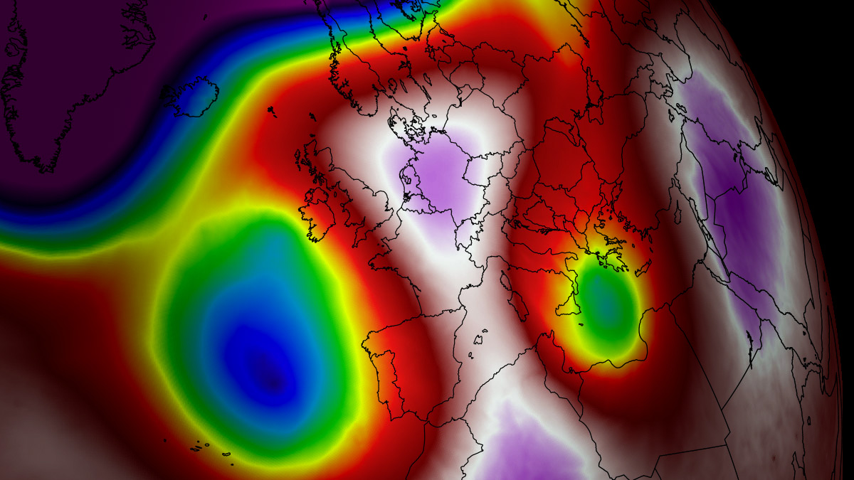
A formidable and expansive high-pressure system, known meteorologically as a "Heat Dome," has begun its encroachment across the European continent. As we move into early September, this atmospheric anomaly is set to deliver an intense, late-season heatwave that threatens to shatter temperature records across Southern Europe, the Mediterranean Basin, and parts of Central Europe.
Forecasts indicate that surface temperatures will reach the upper 30s (°C) across a wide swath of the continent, with localized readings expected to exceed 40°C. This event, driven by a persistent plume of hot air surging north from the Sahara Desert, marks a significant departure from seasonal norms, creating a high-stakes environment for infrastructure, public health, and agricultural sectors.
The Synoptic Mechanism: Understanding the Heat Dome
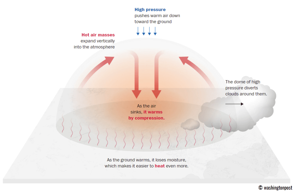
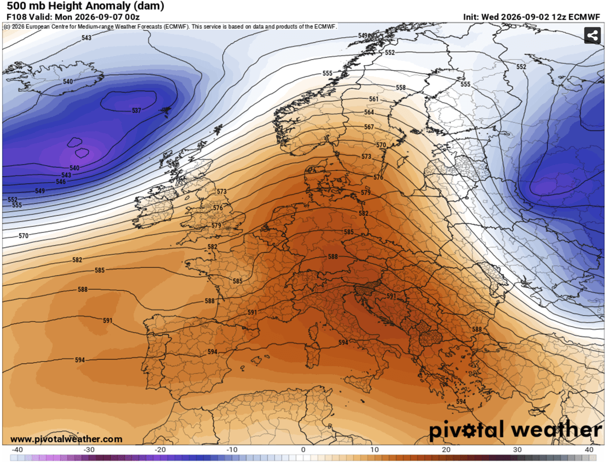
To understand the severity of the coming week, one must first grasp the mechanics of a Heat Dome. At its core, this phenomenon is caused by a massive, stagnant ridge of high pressure that parks itself over a region. It acts as a atmospheric "lid," trapping warm air at all altitudes and preventing the normal circulation that would otherwise disperse it.
As the high-pressure system intensifies, it forces air to sink toward the surface. Known as adiabatic compression, this sinking motion causes the air to heat up significantly as it descends. Because the system is "blocked"—meaning it is locked in place by surrounding atmospheric currents—the trapped air continues to bake under the relentless sun, leading to a feedback loop where the ground dries out, heat is absorbed by the surface, and temperatures climb to record-breaking levels.
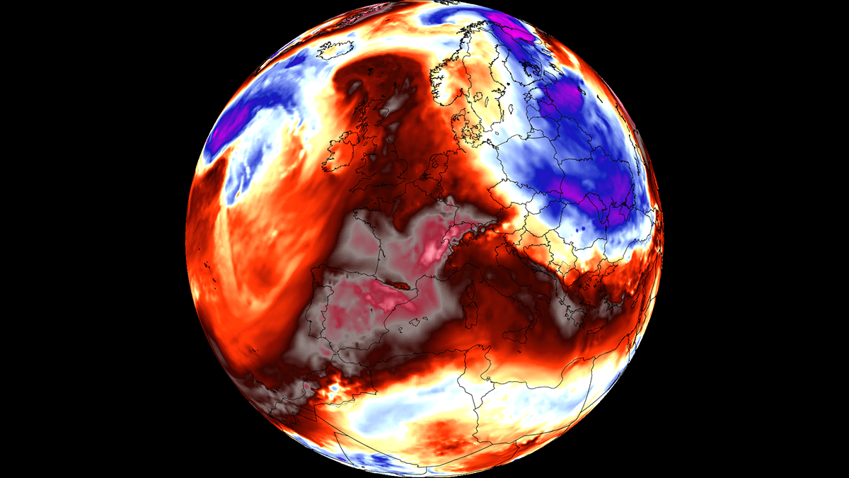
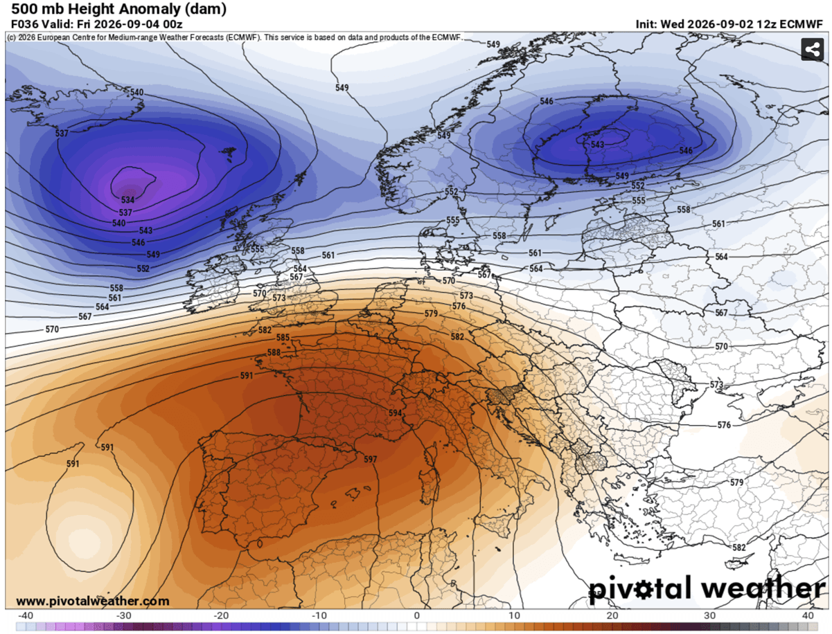
In this specific 2026 event, the "Omega block" pattern—a characteristic shape in the jet stream that prevents weather systems from moving eastward—has allowed this scorching air mass to linger over Spain, France, Italy, and the Balkans with unusual stability.
A Chronological Breakdown of the Heat Surge
The progression of this heatwave is categorized by a steady eastward and northward expansion.
- Late Week (Thursday–Friday): The brunt of the initial surge is concentrated over the Iberian Peninsula. Spain and Portugal are the primary targets, with temperatures projected to peak between 40°C and 44°C. The dry, continental winds are expected to exacerbate the depletion of soil moisture, significantly heightening the risk of wildfires in mountainous and rural regions.
- The Weekend Expansion: As the blocking high shifts, the core of the heat mass will migrate toward Southern and Central France, as well as the Italian Peninsula. By Saturday, the Po Valley in northern Italy and the Tuscany region are expected to see highs consistently pushing toward 40°C.
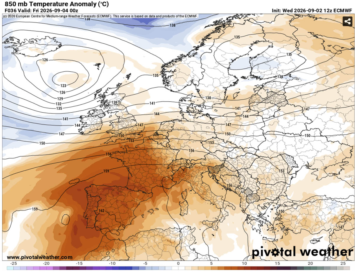
- Early Next Week: The Balkan Peninsula and parts of Central Europe will experience the maximum thermal anomalies. Meteorological models suggest temperatures could be 10°C to 14°C above the long-term seasonal average for early September.
- Mid-Week Pivot: Forecast models hint at a potential "pattern flip" occurring after next Wednesday. A deep low-pressure system arriving from the North Atlantic is expected to break the ridge, introducing cooler, maritime air and potentially providing the first significant relief from the heat, though this may also bring volatile, severe weather to parts of Western Europe.
Supporting Meteorological Data and Projections
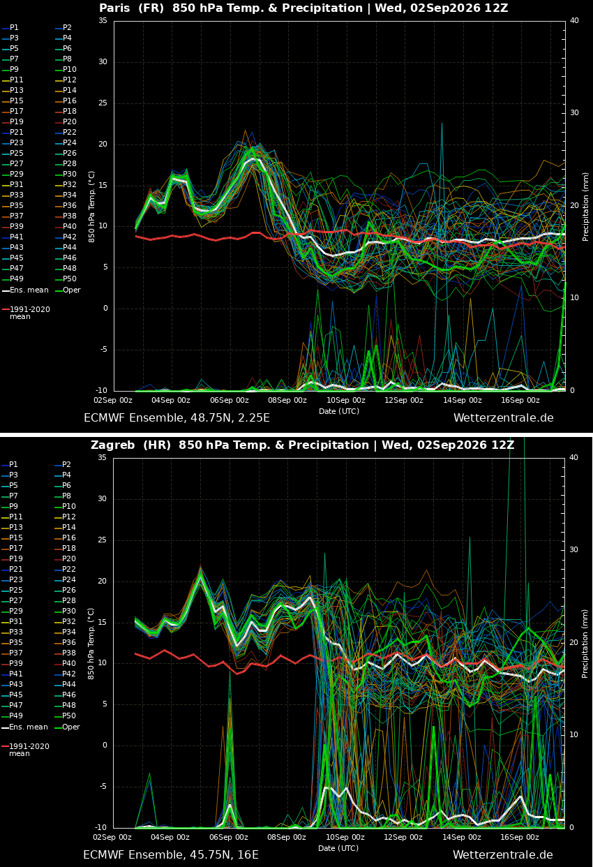
The current forecast models, including data from the GFS and ECMWF, highlight the anomaly’s intensity. By looking at 850 hPa temperature anomalies—a standard metric for measuring the heat of an air mass above the surface—we see that the thermal intensity is not just a surface-level phenomenon but an deep-layer atmospheric event.
The meteograms for major urban centers like Paris, France, and Zagreb, Croatia, show a sustained departure from historical norms. While daytime highs are the most visible threat, the "nocturnal heat stress" is perhaps the most dangerous aspect of this event. In major urban corridors, temperatures are forecast to remain between 22°C and 25°C throughout the night. These "tropical nights" prevent the human body from recovering from the daily thermal load, leading to a cumulative physiological strain that increases the risk of heat-related mortality among vulnerable populations.
Health Implications and Public Safety
The health risks associated with a heat dome of this duration cannot be overstated. Beyond simple heat exhaustion, the prolonged exposure to high temperatures—coupled with the lack of nighttime cooling—increases the risk of heatstroke, cardiovascular strain, and respiratory failure.
Vulnerable Populations
Health authorities have highlighted several demographics at elevated risk:
- The Elderly and Infirm: Reduced physiological ability to thermoregulate makes this group the primary focus for health alerts.
- Outdoor Laborers: Construction workers, agricultural staff, and those in the transport sector face acute risks. Governments in affected regions are already discussing mandatory rest periods and adjusted working hours.
- Urban Residents: The "Urban Heat Island" effect, where concrete and asphalt absorb and re-emit heat, will make cities significantly hotter than rural areas. Households in densely populated, low-income areas with poor ventilation are particularly susceptible to the "lid" effect of the heat dome.
The Heat Index Factor
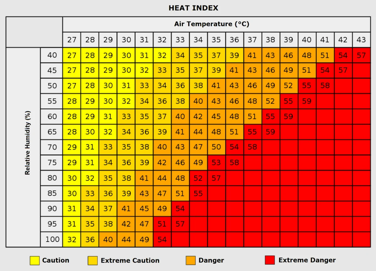
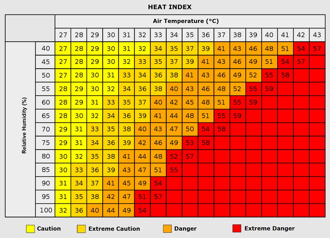
Relative humidity plays a critical role in how the body experiences heat. While the air mass currently moving across Europe is notably dry, localized pockets of humidity near the Mediterranean coast could push the "felt" temperature (Heat Index) well above 45°C. When temperatures exceed 35°C and humidity levels climb, the body’s primary cooling mechanism—sweating—becomes inefficient, rapidly accelerating the onset of heat-related illness.
Implications for Energy and Infrastructure
This extreme heatwave is set to place an immense strain on Europe’s energy infrastructure. As households and businesses turn to air conditioning to cope with the surge, electrical grids across Italy, France, and the Balkans will face peak demand levels typically reserved for the height of July.
Energy providers are bracing for potential instability. If the grid is pushed beyond its capacity, rolling blackouts could become a reality, which would be catastrophic during a period of extreme heat, as it would disable the very cooling systems required to protect human life. Furthermore, the heat poses risks to transportation infrastructure; rail lines have been known to buckle under extreme heat, and road surfaces can soften, leading to significant logistics and transit delays across the affected regions.
Agricultural and Environmental Stress
Beyond human health, the environmental impact of this heat dome is profound. The combination of intense heat and dry winds will accelerate the evaporation of remaining soil moisture, potentially damaging late-season harvests.
The wildfire risk is currently at a critical stage. With vegetation across the Mediterranean already parched from a dry summer, the added thermal stress creates a "tinderbox" scenario. Fire services across Southern Europe are on high alert, with many nations deploying additional aerial firefighting assets to the most vulnerable mountain slopes and forests.
Looking Ahead: The Expected Pattern Flip
The meteorology community is closely watching the transition predicted for mid-next week. While the heat dome is currently the dominant feature, the anticipated arrival of a deep Atlantic trough suggests a dramatic shift in the synoptic pattern.
This transition is expected to deliver a "refreshment" of the atmosphere, with a significant drop in temperatures and the arrival of much-needed precipitation. However, the contrast between the extreme heat of the coming days and the incoming cold-air mass could trigger severe thunderstorms, particularly across Western and Central Europe. These storms, fueled by the residual heat, may produce heavy rainfall, lightning, and strong wind gusts.
As we look toward the remainder of September, the volatility of this event serves as a stark reminder of the shifting climate dynamics affecting the continent. For the next several days, however, the focus remains on resilience and risk mitigation. Residents in the affected zones are urged to heed local weather warnings, stay hydrated, and limit physical exertion during the peak heat hours of 12:00 PM to 6:00 PM.
As the data evolves, further updates will be provided to ensure the public remains informed about the potential for severe weather as the heat dome finally yields to the incoming Atlantic system. Stay tuned for continuous updates as this late-summer weather event develops.